Barton

Heritage Site in Devon East Devon

England

Barton

Merrydown Camping, Old Taunton Road, Dalwood
Merrydown Camping, Old Taunton Road, Dalwood Credit: Jo and Steve Turner

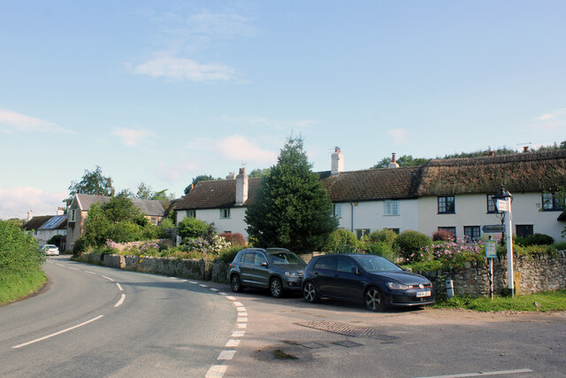
Barton is a small village located in the county of Devon, England. Situated in the South Hams district, it is widely recognized as a heritage site due to its rich historical significance and architectural charm. The village is nestled amidst the picturesque landscape of the South Hams, surrounded by rolling hills, lush green fields, and the serene River Avon.

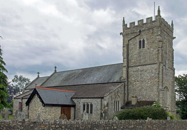
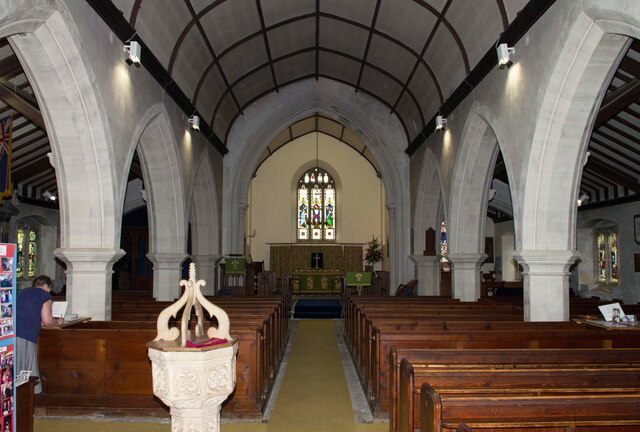
Barton boasts a remarkable collection of ancient buildings and structures, showcasing various architectural styles from different periods. The village is particularly renowned for its well-preserved medieval church, St. Michael and All Angels, which dates back to the 13th century. The church features stunning stained glass windows, intricate carvings, and a striking tower that offers panoramic views of the surrounding countryside.

In addition to its architectural heritage, Barton also has strong connections to the English poet and playwright, Sir John Betjeman. The poet often visited the village and wrote extensively about its beauty and charm in his works. Today, visitors can explore the Betjeman Centre, a museum dedicated to celebrating his life and achievements, located in the heart of Barton.

Furthermore, Barton is surrounded by breathtaking natural beauty, making it an ideal destination for outdoor enthusiasts. The village is a gateway to the Dartmoor National Park, offering opportunities for hiking, cycling, and wildlife spotting.

Overall, Barton, Devon, is a captivating heritage site that combines historical significance, architectural splendor, and natural beauty. It offers visitors a unique glimpse into the past while providing a tranquil escape in the heart of the South Hams.

If you have any feedback on the listing, please let us know in the comments section below.

Barton Images

Images are sourced within 2km of 50.772/-3.057 or Grid Reference SY2597. Thanks to Geograph Open Source API. All images are credited.

Merrydown Camping, Old Taunton Road, Dalwood
Shute Piers, Shute Road, Bakers Mead, Shute Positioned alongside an old Roman and turnpike road the piers were presumably the gateway to the Shute Estate. Graffiti on the piers indicate a date of 1763. Sir John William de la Pole, 6th Baronet (1757 to 1799)  (MP for the rotten borough of West Looe) in 1787 built the 'New Shute House'. The 5th Baronet died in 1760 so it is possible the piers are later than 1763. The east pier was damaged by a car in 2008 and repaired at a cost of about £34,000, the cost met by the insurance company. In March 2011 however another car crashed into it completely demolishing it. The pier was re-built around the end of the same year.
Shute Piers, Shute Road, Bakers Mead, Shute
Positioned alongside an old Roman and turnpike road the piers were presumably the gateway to the Shute Estate. Graffiti on the piers indicate a date of 1763. Sir John William de la Pole, 6th Baronet (1757 to 1799) (MP for the rotten borough of West Looe) in 1787 built the 'New Shute House'. The 5th Baronet died in 1760 so it is possible the piers are later than 1763. The east pier was damaged by a car in 2008 and repaired at a cost of about £34,000, the cost met by the insurance company. In March 2011 however another car crashed into it completely demolishing it. The pier was re-built around the end of the same year.
Gatehouse of Old Shute House, Shute Grade I Listed gatehouse and flanking pavilions of about 1570 or of possibly earlier 16th century origin. Probably aligned on the later parts of Old Shute House before they were demolished in 1785. The gatehouse was probably built by William Pole when he bought the Shute estate in about 1560. During repairs by the Landmark Trust in 1980, supported by a legacy from Gladys M Calthrop, a Jacobean plaster ceiling from a house in Barnstaple demolished in the 1930s was installed in an upper room. The National Trust (who lease the gatehouse to the Landmark Trust) closed the house to the public in 2021 for use 'solely as a holiday cottage', reportedly to recover huge losses caused by the coronavirus lockdowns. It was announced in October 2020 that the Landmark Trust’s Shute Gatehouse will receive £28,720 of capital funding from the government to help recovery from the coronavirus lockdowns.
Gatehouse of Old Shute House, Shute
Grade I Listed gatehouse and flanking pavilions of about 1570 or of possibly earlier 16th century origin. Probably aligned on the later parts of Old Shute House before they were demolished in 1785. The gatehouse was probably built by William Pole when he bought the Shute estate in about 1560. During repairs by the Landmark Trust in 1980, supported by a legacy from Gladys M Calthrop, a Jacobean plaster ceiling from a house in Barnstaple demolished in the 1930s was installed in an upper room. The National Trust (who lease the gatehouse to the Landmark Trust) closed the house to the public in 2021 for use 'solely as a holiday cottage', reportedly to recover huge losses caused by the coronavirus lockdowns. It was announced in October 2020 that the Landmark Trust’s Shute Gatehouse will receive £28,720 of capital funding from the government to help recovery from the coronavirus lockdowns.
Nurse's Cottage, 1 Beagles Row, Shute Grade II Listed terrace of 18th century cottages. Number one is the only one thatched and is a two storey 89.8 sq m three bedroom dwelling. See also <a href="https://www.geograph.org.uk/photo/6952960">SY2597 : Beagles Row, Shute</a>.
Nurse's Cottage, 1 Beagles Row, Shute
Grade II Listed terrace of 18th century cottages. Number one is the only one thatched and is a two storey 89.8 sq m three bedroom dwelling. See also SY2597 : Beagles Row, Shute.
Beagles Row, Shute Grade II Listed terrace of 18th century cottages. Number one is the only one thatched and is a two storey 89.8 sq m three bedroom dwelling. Number two is 158 sq m over two floors but only two bedroom. See Also <a href="https://www.geograph.org.uk/photo/6952958">SY2597 : Nurse's Cottage, 1 Beagles Row, Shute</a>.
Beagles Row, Shute
Grade II Listed terrace of 18th century cottages. Number one is the only one thatched and is a two storey 89.8 sq m three bedroom dwelling. Number two is 158 sq m over two floors but only two bedroom. See Also SY2597 : Nurse's Cottage, 1 Beagles Row, Shute.
War Memorial, Shute Grade II Listed first world war memorial erected about 1920. Around 2016 a handrail was added to assist in climbing the steps.
War Memorial, Shute
Grade II Listed first world war memorial erected about 1920. Around 2016 a handrail was added to assist in climbing the steps.
Lych Gate, St Michael's Church, Haddon Road, Shute
St Michael's Church, Haddon Road, Shute Grade II* Listed parish church. A 13th century cruciform plan with central tower was extended with the north aisle in 1811. Written records go back to 1205 but it is believed that there may have been a Saxon Church on this site. Some time after 1205 the Manor of Shute was created and given to Lucas de la Shute who built a Manor House and Church. In the 15th Century the South Transept was widened, and the Lady Chapel erected on the North side of the Chancel. The church was renovated in 1868 and a new vestry was built in 1869 at the end of the north transept. In 1967 the sanctuary was refashioned and the Lady Chapel refurnished. The chamber organ, originally a barrel-and -keyboard instrument, was built in 1800 for the new Shute House. There were three bells in the tower in 1553 which survived until January 7th 1760 when they were re-cast into 4 and a fifth added. Currently 4 of the 6 bells are 1761 by Thomas Bilbie and the remaining, 1864 by J Warner and 1923 by John Taylor & Co.
St Michael's Church, Haddon Road, Shute
Grade II* Listed parish church. A 13th century cruciform plan with central tower was extended with the north aisle in 1811. Written records go back to 1205 but it is believed that there may have been a Saxon Church on this site. Some time after 1205 the Manor of Shute was created and given to Lucas de la Shute who built a Manor House and Church. In the 15th Century the South Transept was widened, and the Lady Chapel erected on the North side of the Chancel. The church was renovated in 1868 and a new vestry was built in 1869 at the end of the north transept. In 1967 the sanctuary was refashioned and the Lady Chapel refurnished. The chamber organ, originally a barrel-and -keyboard instrument, was built in 1800 for the new Shute House. There were three bells in the tower in 1553 which survived until January 7th 1760 when they were re-cast into 4 and a fifth added. Currently 4 of the 6 bells are 1761 by Thomas Bilbie and the remaining, 1864 by J Warner and 1923 by John Taylor & Co.
Shute Community Primary School, Haddon Road, Shute
Former Shute Arms, Shute Road, Seaton Junction Built in 1898 opposite Seaton Junction Station it was originally a hotel with a public bar. Danny and Betty Brown owned it between 1982 and 1985 and in 1982 it burnt down and was rebuilt by them during 1983. Other landlords/owners were 1902 William Hayward Wilkins, 1910 Henry Thomas Weeks and 1914 and 1923 Harry Edward Hewes. A John Burgum also owned it for a time, possibly prior to the Browns. Planning was approved in March 2008 for conversion to five residential units after 3 previous applications had been refused.
Former Shute Arms, Shute Road, Seaton Junction
Built in 1898 opposite Seaton Junction Station it was originally a hotel with a public bar. Danny and Betty Brown owned it between 1982 and 1985 and in 1982 it burnt down and was rebuilt by them during 1983. Other landlords/owners were 1902 William Hayward Wilkins, 1910 Henry Thomas Weeks and 1914 and 1923 Harry Edward Hewes. A John Burgum also owned it for a time, possibly prior to the Browns. Planning was approved in March 2008 for conversion to five residential units after 3 previous applications had been refused.
Former Station, Shute Road, Seaton Junction The London and South Western Railway opened 'Colyton for Seaton' station on 19 July 1860. Architecture was standardised on a Gothic design produced by Sir William Tite. Whilst based on the same fundamental design, variation always existed between the station buildings. Extending from the building’s southern façade was an attractive flat-roofed canopy, 60-feet in length, supported upon four cast-iron stanchions. When the Seaton & Beer Railway opened in March 1868 the  name was changed to 'Colyton Junction' and then 'Seaton Junction' on 18 July 1869. Starting in 1927 the station was substantially redesigned by Southern Railway with changes to platforms and canopies. Around this time on the up platform emerged the buildings of Express Dairies, which opened a milk processing plant beside the station, partly visible on the right of the photo. From 1955 the Southern Region started cosmetic refurbishment of the stations resulting in the main building being subjected to an all-over crème paint scheme. The branch line closed on 7th March 1966, the station ceasing to passenger traffic on the same date. Goods traffic ceased in the April but facilities were still maintained for Express Dairies until about 1973. All structures upon the down platform were removed but the platform left in situ. By April 1989, the crème finish of the main building had mostly gone but the main entrance doors had been restored. The British Railways Board (BRB (Residuary) Ltd.) sold the main buildings to a developer in November 2008 (probably the same one that bought the Shute Arms Hotel) and in Oct 2010 and again in May 2014 planning was approved for two dwellings.
Former Station, Shute Road, Seaton Junction
The London and South Western Railway opened 'Colyton for Seaton' station on 19 July 1860. Architecture was standardised on a Gothic design produced by Sir William Tite. Whilst based on the same fundamental design, variation always existed between the station buildings. Extending from the building’s southern façade was an attractive flat-roofed canopy, 60-feet in length, supported upon four cast-iron stanchions. When the Seaton & Beer Railway opened in March 1868 the name was changed to 'Colyton Junction' and then 'Seaton Junction' on 18 July 1869. Starting in 1927 the station was substantially redesigned by Southern Railway with changes to platforms and canopies. Around this time on the up platform emerged the buildings of Express Dairies, which opened a milk processing plant beside the station, partly visible on the right of the photo. From 1955 the Southern Region started cosmetic refurbishment of the stations resulting in the main building being subjected to an all-over crème paint scheme. The branch line closed on 7th March 1966, the station ceasing to passenger traffic on the same date. Goods traffic ceased in the April but facilities were still maintained for Express Dairies until about 1973. All structures upon the down platform were removed but the platform left in situ. By April 1989, the crème finish of the main building had mostly gone but the main entrance doors had been restored. The British Railways Board (BRB (Residuary) Ltd.) sold the main buildings to a developer in November 2008 (probably the same one that bought the Shute Arms Hotel) and in Oct 2010 and again in May 2014 planning was approved for two dwellings.
St Giles', Kilmington, Devon
St. Michael's, Shute, Devon Eastern elevation
St. Michael's, Shute, Devon
Eastern elevation
St. Michael's, Shute, Devon
St. Michael's, Shute, Devon North-East chapel to Sir William Pole
St. Michael's, Shute, Devon
North-East chapel to Sir William Pole
St. Michael's, Shute, Devon The Transept
St. Michael's, Shute, Devon
The Transept
St. Michael's, Shute, Devon The Chancel and High Altar
St. Michael's, Shute, Devon
The Chancel and High Altar
Show me another place!

Barton is located at Grid Ref: SY2597 (Lat: 50.772, Lng: -3.057)

Administrative County: Devon

District: East Devon

Police Authority: Devon and Cornwall

What 3 Words

///racetrack.relaxing.enhanced. Near Colyton, Devon

Related Wikis

Shute, Devon

Shute is a village, parish and former manor located 3 miles (5 km) west of Axminster in East Devon, off the A35 road. It is surrounded by farmland and...

Old Shute House

See also: New Shute HouseOld Shute House (known as Shute Barton between about 1789 and the 20th century), located at Shute, near Colyton, Axminster, Devon...
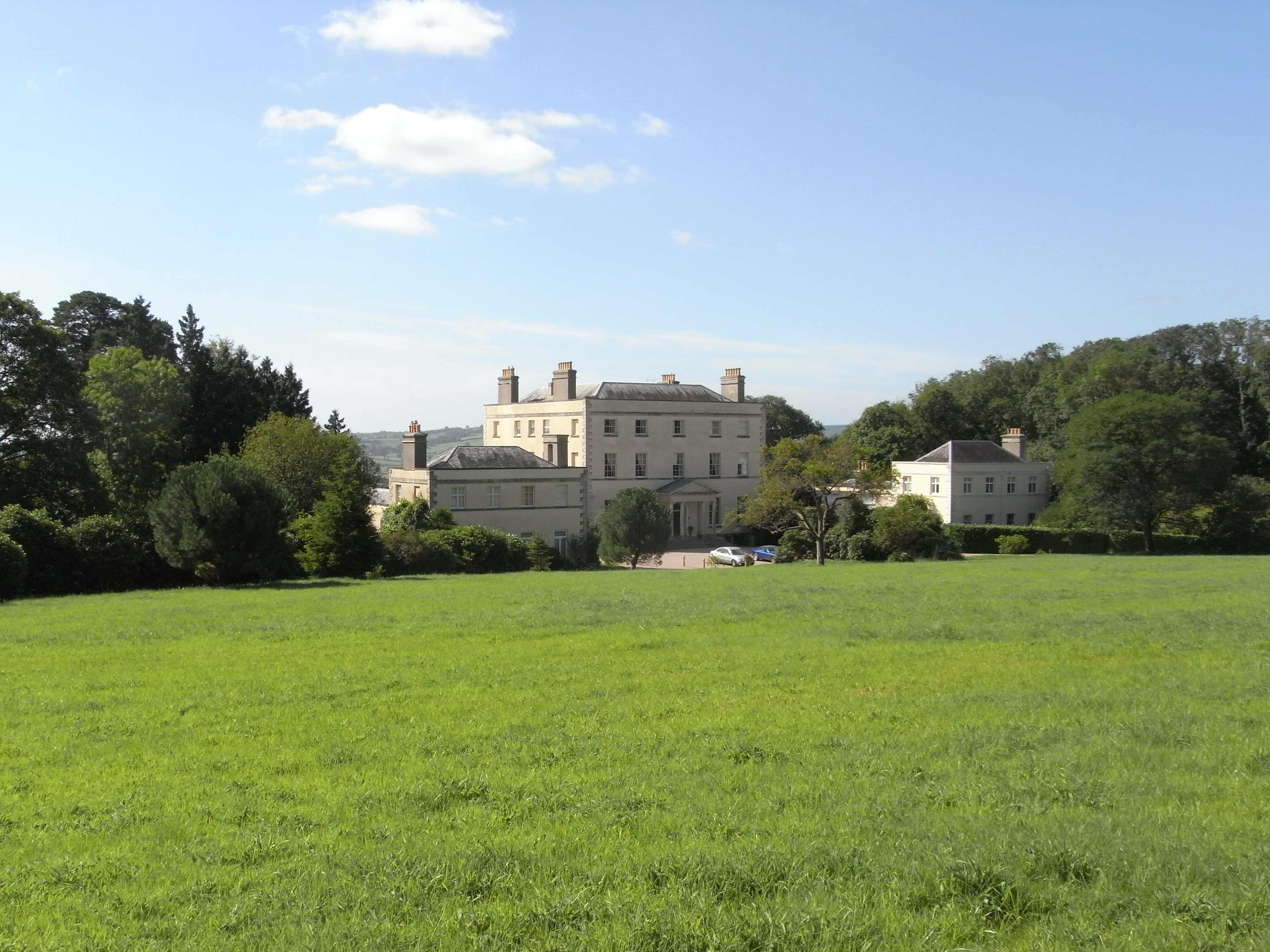
New Shute House

New Shute House is a late Palladian country house built between 1785 and 1789 by Sir John de la Pole, 6th Baronet (1757–1799) and is situated within the...

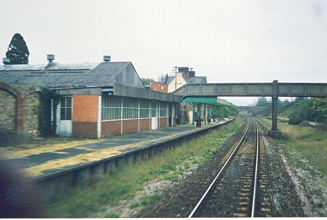
Seaton Junction railway station

Seaton Junction is a closed railway station on the West of England Main Line from London Waterloo to Exeter. It was situated 3 miles west of Axminster...

St Mary at the Cross, Whitford

St Mary at the Cross is a Church of England church in Whitford, Devon, England. It was built in 1908 and remains active as part of the Five Alive Mission...

Kilmington, Devon

Kilmington is a village near Axminster in East Devon off the A35 road. The village population at the 2011 Census was 830. Kilmington is a major part of...

Whitford, Devon

Whitford is a village near Axminster in East Devon. It is situated on the western bank of the River Axe, which is crossed via a small bridge with a weir...

Loughwood Meeting House

Loughwood Meeting House is a historic Baptist chapel, 1 mile (1.6 km) south of the village of Dalwood, Devon in England. There was a meeting house on...

Nearby Amenities

Located within 500m of 50.772,-3.057
Shute
Place: village
Wikidata: Q2344154
Wikipedia: en:Shute, Devon
Lat/Long: 50.772606/-3.0622643
Post Box
Post Box Type: lamp
Royal Cypher: EIIR
Royal Cypher Wikidata: Q33102113
Lat/Long: 50.7725446/-3.0618898
The Beacon
Direction: S
Tourism: viewpoint
Lat/Long: 50.7719623/-3.0532433
Barrier: stile
Lat/Long: 50.767927/-3.0588231
Shute Armada Beacon House
Building: yes
Lat/Long: 50.772002/-3.0532984
Historic: memorial
Memorial: war_memorial
Lat/Long: 50.7725932/-3.0619362
Power: pole
Source: bing
Transformer: distribution
Lat/Long: 50.7718109/-3.0634636
Ele: 163.7
Inscription: CS BM S3743
Man Made: survey_point
Lat/Long: 50.7750283/-3.0568398
Power: pole
Source: bing
Lat/Long: 50.7702689/-3.0568801
Power: pole
Source: bing
Lat/Long: 50.7703834/-3.0555725
Power: pole
Source: bing
Lat/Long: 50.7691604/-3.0583808
Power: pole
Source: bing
Lat/Long: 50.7681629/-3.0601376
Power: pole
Source: bing
Transformer: distribution
Lat/Long: 50.7684937/-3.0592257
The data included in this document is from www.openstreetmap.org. The data is made available under ODbL.

Have you been to Barton?

Leave your review of Barton below (or comments, questions and feedback).