Barham Ct

Heritage Site in Kent Maidstone

England

Barham Ct

Oast House
Oast House Credit: Oast House Archive

Barham Court, located in the county of Kent, England, is a historic heritage site that holds great cultural and architectural significance. Situated in the village of Barham, this magnificent country house dates back to the 18th century and is a fine example of Georgian architecture.

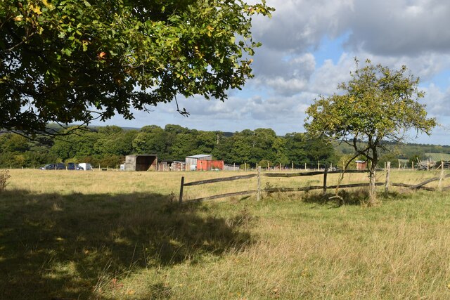
The estate boasts a sprawling landscape with extensive gardens that have been meticulously maintained over the years. These gardens include beautifully manicured lawns, vibrant flower beds, and a variety of mature trees, providing a picturesque setting for visitors to explore and enjoy. The tranquil atmosphere and scenic views make Barham Court an ideal place for leisurely walks or picnics.

The main house, constructed of red brick, features a symmetrical facade with elegant sash windows and a grand entrance. The interior is equally impressive, showcasing ornate plasterwork, intricate woodwork, and stunning period features throughout. The estate has served various purposes over the years, including being used as a private residence, a wedding venue, and a filming location for television and film productions.

Barham Court has also played a role in local history, with the estate being mentioned in historical records dating back centuries. Its rich heritage and connection to the local community make it an important landmark in Kent.

Today, Barham Court is privately owned but occasionally opens its doors to the public for special events, guided tours, and private functions. It continues to be cherished for its architectural beauty, historical significance, and as a cherished part of Kent's cultural heritage.

If you have any feedback on the listing, please let us know in the comments section below.

Barham Ct Images

Images are sourced within 2km of 51.255/0.443 or Grid Reference TQ7053. Thanks to Geograph Open Source API. All images are credited.

Fields beside the River Medway
Fields above the Medway near Tutsham Hall
Footpath between fences at Tutsham hall
Footpath on track through Tutsham Hall Many of the former farm buildings have been converted into separate residences.
Footpath on track through Tutsham Hall
Many of the former farm buildings have been converted into separate residences.
View along fence towards Tutsham Cottages
Fields beside Ewell Lane
Paddock in valley at West Farleigh
Footpath on track through buildings at Smiths Hill
The green at Farleigh Green
The Good Intent, Farleigh Green Public house overlooking the triangular green.
The Good Intent, Farleigh Green
Public house overlooking the triangular green.
View across the green at Farleigh Green The village sign says West Farleigh, although the area around the green is shown as Farleigh Green on the OS map.
View across the green at Farleigh Green
The village sign says West Farleigh, although the area around the green is shown as Farleigh Green on the OS map.
West Farleigh village sign The village sign says West Farleigh, although the area around the green is shown as Farleigh Green on the OS map. For the sign in context, see <a href="https://www.geograph.org.uk/photo/7302086">TQ7252 : View across the green at Farleigh Green</a>.
West Farleigh village sign
The village sign says West Farleigh, although the area around the green is shown as Farleigh Green on the OS map. For the sign in context, see TQ7252 : View across the green at Farleigh Green.
View across former orchard into Medway Valley This field is marked as orchard on the OS 1:25,000 map.
View across former orchard into Medway Valley
This field is marked as orchard on the OS 1:25,000 map.
Fishing by Barming Bridge
View across Barming Bridge
Medway riverside path near Barming
Riverside meadow and railway embankment With the spire of Barming Church in the distance.
Riverside meadow and railway embankment
With the spire of Barming Church in the distance.
Show me another place!

Barham Ct is located at Grid Ref: TQ7053 (Lat: 51.255, Lng: 0.443)

Administrative County: Kent

District: Maidstone

Police Authority: Kent

What 3 Words

///overlaps.empires.brochure. Near Wateringbury, Kent

Related Wikis

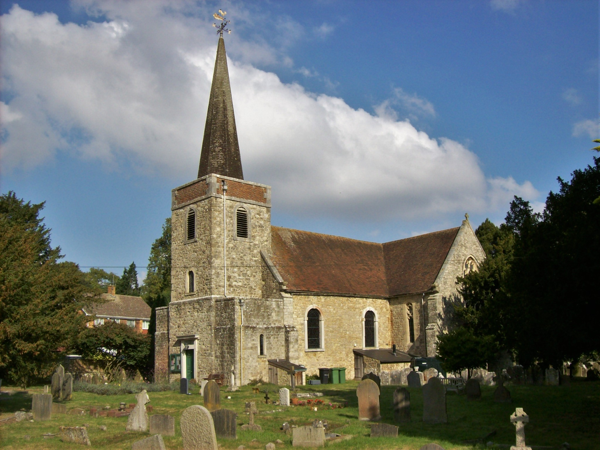
St Peter's and St Paul's Church, Teston

St Peter's and St Paul's is a parish church in Teston, Kent. It is a Grade II* listed building and was rebuilt in 1736 for Sir Philip Boteler of Barham...

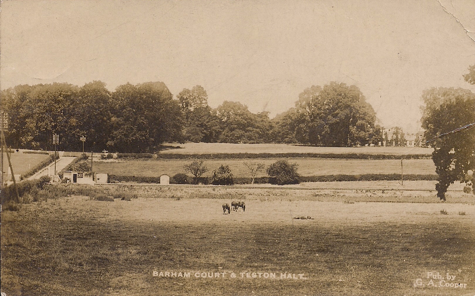
Teston Crossing Halt railway station

Teston Crossing Halt was situated on what is now the Medway Valley Line, south of Maidstone, in Kent, and served Teston and West Farleigh. It opened on...

Teston

Teston /ˈtiːstən/ or /ˈtiːsən/ is a village in the Maidstone District of Kent, England. It is located on the A26 road out of Maidstone, four miles (6...

Barham Court

Barham Court is an English country house in the village of Teston, Kent. == History == It was once the home of Reginald Fitz Urse, one of the knights who...
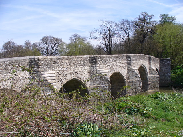
Teston Bridge

Teston Bridge is a road bridge across the River Medway, between Teston and West Farleigh in Kent, England. == History == The bridge was constructed in...

West Farleigh

West Farleigh is a village and civil parish four miles (6km) southwest of Maidstone in the county of Kent. The parish has a population of approximately...

All Saints Church, West Farleigh

All Saints is a parish church in West Farleigh, Kent. It was begun in the 11th century and is a Grade I listed building. == Building == The church was...

Smiths Hall

Smiths Hall, known as West Farleigh Hall from the early 20th century until the 1990s, is an 18th-century country house in West Farleigh, Kent. == History... ==

Related Videos

Medway Valley Walk Ep 1 Gentle River Stroll with FREE Food

Pastor Steve and I had a gentle (8 mile) river stroll on Saturday. We walked from Allington Lock in Maidstone to Wouldham ...

Walking along the banks of the River Medway, Maidstone, UK. #riverMedway #maidstone #kent

Audio track: Undercover Vampire Policeman by Chris Zabriskie is licensed under a Creative Commons Attribution 4.0 licence.

Best Stealth River Camping| River Medway Valley Walk ep.3

Looking for best river stealth camping places? Friday night I went out to relax on River Medway and to find best place for a stealth ...

Travel on Princess 330

Travelling on the river Medway 17kts cruising speed against the tide.

Nearby Amenities

Located within 500m of 51.255,0.443
Railway: level_crossing
Lat/Long: 51.2538161/0.4454857
Bench
Lat/Long: 51.2523897/0.4448683
Vending Machine
Parking Ticket Machine
Vending: parking_tickets
Lat/Long: 51.2532332/0.4451663
Vending Machine
Vending: parking_tickets
Lat/Long: 51.2522893/0.4442324
Bench
Ele: 11
Lat/Long: 51.2517316/0.4435199
Bird Table
Lat/Long: 51.2525616/0.4450314
Board Type: notice
Information: board
Tourism: information
Lat/Long: 51.2530075/0.4453662
Bus Stop
The Street
Naptan AtcoCode: 2400A000460A
Naptan Bearing: W
Naptan CommonName: The Street
Naptan Indicator: opp
Naptan Landmark: The Street
Naptan NaptanCode: kntadmdw
Naptan Street: Tonbridge Road
Naptan Verified: no
Public Transport: platform
Shelter: yes
Source: naptan_import
Lat/Long: 51.2538611/0.4409898
Bus Stop
The Street
Naptan AtcoCode: 2400A000470A
Naptan Bearing: E
Naptan CommonName: The Street
Naptan Indicator: adj
Naptan Landmark: The Street
Naptan NaptanCode: kntadmga
Naptan Street: Tonbridge Road
Naptan Verified: no
Public Transport: platform
Shelter: yes
Source: naptan_import
Lat/Long: 51.2540118/0.4406682
Barrier: stile
Lat/Long: 51.2532745/0.4462201
Turning Circle
Lat/Long: 51.2574599/0.4406221
Barrier: kissing_gate
Bicycle: no
Foot: yes
Material: metal
Lat/Long: 51.253048/0.447184
Toilets
Designation: Toilets
Source: Local knowledge
Lat/Long: 51.2533429/0.4451561
Leisure: playground
Lat/Long: 51.2549319/0.4409246
Post Office
Teston Post Office
Addr Postcode: ME18 5AH
Brand: Post Office
Brand Wikidata: Q1783168
Ref Pol Id: 124193
Lat/Long: 51.2549855/0.4406191
Turning Circle
Lat/Long: 51.256637/0.4388594
Barrier: stile
Foot: yes
Material: wood
Stile: stepover
Lat/Long: 51.2531726/0.446729
Railway: level_crossing
Lat/Long: 51.2537861/0.4455326
Bench
Lat/Long: 51.2527932/0.4469338
Post Box
Operator: Royal Mail
Post Box Type: wall
Ref: ME18 177
Lat/Long: 51.2550762/0.4404427
Teston Village Stores
Shop: convenience
Lat/Long: 51.2550144/0.4406344
Generator Method: photovoltaic
Generator Output Electricity: yes
Generator Source: solar
Generator Type: solar_photovoltaic_panel
Location: roof
Power: generator
Lat/Long: 51.256374/0.4365858
Generator Method: photovoltaic
Generator Output Electricity: yes
Generator Source: solar
Generator Type: solar_photovoltaic_panel
Location: roof
Power: generator
Lat/Long: 51.2565553/0.4412971
Generator Method: photovoltaic
Generator Output Electricity: yes
Generator Source: solar
Generator Type: solar_photovoltaic_panel
Location: roof
Power: generator
Lat/Long: 51.2568617/0.4404093
Generator Method: photovoltaic
Generator Output Electricity: yes
Generator Source: solar
Generator Type: solar_photovoltaic_panel
Location: roof
Power: generator
Lat/Long: 51.2563975/0.4385895
Generator Method: photovoltaic
Generator Output Electricity: yes
Generator Source: solar
Generator Type: solar_photovoltaic_panel
Location: roof
Power: generator
Lat/Long: 51.2543395/0.4380289
Telephone
Booth: K6
Covered: booth
Listed Status: Grade II
Lat/Long: 51.2549271/0.4401701
Historic: memorial
Memorial: war_memorial
Lat/Long: 51.2550267/0.4399341
Advertising: board
Lat/Long: 51.2548868/0.4404428
Defibrillator
Defibrillator Location: outside Teston Village Hall
Emergency: defibrillator
Indoor: no
Lat/Long: 51.254993/0.4405927
Give Way
Direction: forward
Lat/Long: 51.2544074/0.4446244
Colour: yellow
Marker: stone
Material: concrete
Utility: gas
Lat/Long: 51.2538613/0.4457415
Colour: yellow
Marker: stone
Material: concrete
Utility: gas
Lat/Long: 51.2539497/0.4456216
The data included in this document is from www.openstreetmap.org. The data is made available under ODbL.

Have you been to Barham Ct?

Leave your review of Barham Ct below (or comments, questions and feedback).