Balmerino Abbey
Heritage Site in Fife
Scotland
Balmerino Abbey

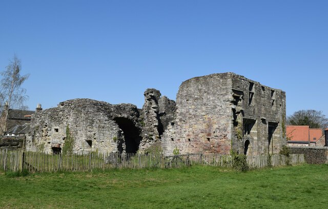
Balmerino Abbey, located in Fife, Scotland, is a well-preserved medieval abbey that holds significant historical and architectural importance. Founded in 1229 by Queen Ermengarde, the widow of King William the Lion, it was constructed as a Cistercian monastery and was home to a community of monks.
The abbey's architecture showcases a mix of Gothic and Romanesque styles. The ruins today display the remnants of the original church, chapter house, and cloister. The church, with its impressive dimensions, features a central nave with aisles and a transept, while the chapter house boasts beautiful ribbed vaulting. The cloister, although partly ruined, still exhibits its original layout.
Throughout its existence, Balmerino Abbey played a significant role in Scottish history. It was a place of religious devotion, education, and agricultural productivity, with the monks engaging in farming, fishing, and milling activities. Additionally, the abbey served as a burial ground for prominent Scottish families, including the Leslie and Scott clans.
Following the Scottish Reformation in the 16th century, Balmerino Abbey fell into decline. Its monastic life was dissolved, and the buildings were abandoned. Despite this, the abbey managed to survive and retain much of its original structure.
Today, Balmerino Abbey stands as a Scheduled Ancient Monument and a protected heritage site. Visitors can explore the ruins and learn about the abbey's rich history through informational panels on-site. The tranquil setting, surrounded by scenic countryside, offers a serene atmosphere, making it a popular tourist destination in Fife.
If you have any feedback on the listing, please let us know in the comments section below.
Balmerino Abbey Images
Images are sourced within 2km of 56.411/-3.043 or Grid Reference NO3524. Thanks to Geograph Open Source API. All images are credited.


Balmerino Abbey is located at Grid Ref: NO3524 (Lat: 56.411, Lng: -3.043)
Unitary Authority: Fife
Police Authority: Fife
What 3 Words
///plantings.backs.producing. Near Invergowrie, Perth & Kinross
Nearby Locations
Related Wikis

Balmerino
Balmerino is a small village and former monastic centre in Fife, Scotland. It is the home of Balmerino Abbey and the former abbots of Balmerino who were...

Balmerino Abbey
Balmerino Abbey, or St Edward's Abbey, in Balmerino, Fife, Scotland, was a Cistercian monastic community which has been ruinous since the 16th century...
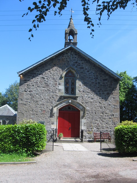
Balmerino Parish Church
Balmerino Parish Church is a Church of Scotland parish church in Bottomcraig, Fife, Scotland. The church sits in the centre of the small village where...
Bottomcraig
Bottomcraig is a village in Fife, Scotland located near Balmerino and The Gauldry. The village is home to Balmerino Parish Church, built in 1811, and the...
Nearby Amenities
Located within 500m of 56.411,-3.043Have you been to Balmerino Abbey?
Leave your review of Balmerino Abbey below (or comments, questions and feedback).