Ash House

Heritage Site in Devon West Devon

England

Ash House

Old circular AA sign on the former B3217 in Monkokehampton Old AA Sign located on the wall of an old workshop, now a cottage called The Old Forge, on the east side of the former B3217 in Monkokehampton, 8 miles north of Okehampton. Monkokehampton parish.

This is the Circular, village name on black band, no Motor Union symbol or name type, dating from 1923, showing distances Okehampton 7½ Iddesleigh 2¼ London 196. Removed some time between July 2014 and August 2022.

There were five series of AA signs, mostly dating from 1923 and made by Francis & Co / Franco in Deptford, London. The village name and distance to London or Dublin were normally displayed.

See also <span class="nowrap"><a title="https://www.flickr.com/photos/livesurfcams/14394800250" rel="nofollow ugc noopener" href="https://www.flickr.com/photos/livesurfcams/14394800250">Link</a><img style="margin-left:2px;" alt="External link" title="External link - shift click to open in new window" src="https://s1.geograph.org.uk/img/external.png" width="10" height="10"/></span> , <span class="nowrap"><a title="https://www.flickr.com/photos/bumbishop/5656595" rel="nofollow ugc noopener" href="https://www.flickr.com/photos/bumbishop/5656595">Link</a><img style="margin-left:2px;" alt="External link" title="External link - shift click to open in new window" src="https://s1.geograph.org.uk/img/external.png" width="10" height="10"/></span> and <span class="nowrap"><a title="https://www.flickr.com/photos/bridgemarkertim/3966823734" rel="nofollow ugc noopener" href="https://www.flickr.com/photos/bridgemarkertim/3966823734">Link</a><img style="margin-left:2px;" alt="External link" title="External link - shift click to open in new window" src="https://s1.geograph.org.uk/img/external.png" width="10" height="10"/></span>.

Milestone Society National ID: DV-MONKO
Old circular AA sign on the former B3217 in Monkokehampton Credit: A Rosevear

Ash House, located in Devon, England, is a significant heritage site with a rich history dating back to the 13th century. This medieval manor house, nestled amidst picturesque countryside, has witnessed centuries of British history and stands as a testament to the architectural and cultural heritage of the region.

Originally built as a fortified manor, Ash House underwent several renovations and expansions over the years. The house features a mix of architectural styles, including medieval, Tudor, and Georgian, which beautifully reflect the changing times and tastes of the various owners.

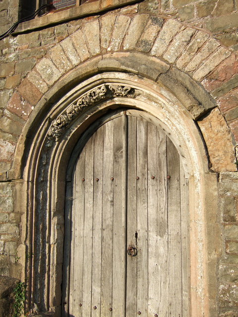
The house boasts an impressive Great Hall, which is believed to be the oldest part of the building, with its magnificent oak-beamed ceiling and intricately carved fireplace. The Tudor wing, added in the 16th century, showcases exquisite paneling and ornate plasterwork, while the Georgian additions provide a glimpse into the elegant lifestyle of the 18th century nobility. The surrounding gardens, with their manicured lawns, charming flower beds, and ancient trees, further enhance the beauty and serenity of the estate.

Ash House has a colorful history, with notable owners including Sir Walter Raleigh and the Duke of Monmouth. It has also been a witness to significant events, including the English Civil War and the arrival of American troops during World War II.

Today, Ash House is open to the public, offering guided tours that provide a fascinating insight into its history and architecture. The site also hosts various events and exhibitions, showcasing the cultural heritage of Devon and providing visitors with an immersive experience of the past.

If you have any feedback on the listing, please let us know in the comments section below.

Ash House Images

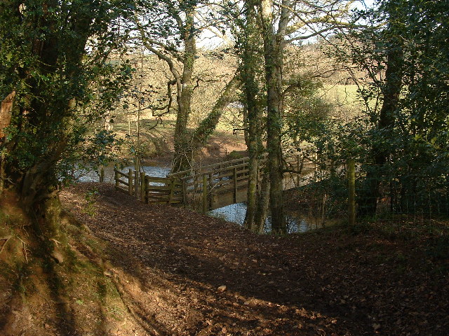
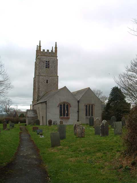
Images are sourced within 2km of 50.84/-4.023 or Grid Reference SS5706. Thanks to Geograph Open Source API. All images are credited.

Old circular AA sign on the former B3217 in Monkokehampton Old AA Sign located on the wall of an old workshop, now a cottage called The Old Forge, on the east side of the former B3217 in Monkokehampton, 8 miles north of Okehampton. Monkokehampton parish.

This is the Circular, village name on black band, no Motor Union symbol or name type, dating from 1923, showing distances Okehampton 7½ Iddesleigh 2¼ London 196. Removed some time between July 2014 and August 2022.

There were five series of AA signs, mostly dating from 1923 and made by Francis & Co / Franco in Deptford, London. The village name and distance to London or Dublin were normally displayed.

See also <span class="nowrap"><a title="https://www.flickr.com/photos/livesurfcams/14394800250" rel="nofollow ugc noopener" href="https://www.flickr.com/photos/livesurfcams/14394800250">Link</a><img style="margin-left:2px;" alt="External link" title="External link - shift click to open in new window" src="https://s1.geograph.org.uk/img/external.png" width="10" height="10"/></span> , <span class="nowrap"><a title="https://www.flickr.com/photos/bumbishop/5656595" rel="nofollow ugc noopener" href="https://www.flickr.com/photos/bumbishop/5656595">Link</a><img style="margin-left:2px;" alt="External link" title="External link - shift click to open in new window" src="https://s1.geograph.org.uk/img/external.png" width="10" height="10"/></span> and <span class="nowrap"><a title="https://www.flickr.com/photos/bridgemarkertim/3966823734" rel="nofollow ugc noopener" href="https://www.flickr.com/photos/bridgemarkertim/3966823734">Link</a><img style="margin-left:2px;" alt="External link" title="External link - shift click to open in new window" src="https://s1.geograph.org.uk/img/external.png" width="10" height="10"/></span>.

Milestone Society National ID: DV-MONKO
Old circular AA sign on the former B3217 in Monkokehampton
Old AA Sign located on the wall of an old workshop, now a cottage called The Old Forge, on the east side of the former B3217 in Monkokehampton, 8 miles north of Okehampton. Monkokehampton parish. This is the Circular, village name on black band, no Motor Union symbol or name type, dating from 1923, showing distances Okehampton 7½ Iddesleigh 2¼ London 196. Removed some time between July 2014 and August 2022. There were five series of AA signs, mostly dating from 1923 and made by Francis & Co / Franco in Deptford, London. The village name and distance to London or Dublin were normally displayed. See also LinkExternal link , LinkExternal link and LinkExternal link. Milestone Society National ID: DV-MONKO
Monkokehampton Mill The last working water-powered corn mill in Devon, heritage and preserved mills aside. Built in the late 19th century, it stands by a leat from the Okement and was originally powered by two small overshot waterwheels. One survives in working order today.
Monkokehampton Mill
The last working water-powered corn mill in Devon, heritage and preserved mills aside. Built in the late 19th century, it stands by a leat from the Okement and was originally powered by two small overshot waterwheels. One survives in working order today.
Tarka Trail: Foot bridge over the Okement There's only one word in this square on the Explorer map. That's the 'Ford' over the River Okement that's just downstream of this foot bridge.
Tarka Trail: Foot bridge over the Okement
There's only one word in this square on the Explorer map. That's the 'Ford' over the River Okement that's just downstream of this foot bridge.
St James' Church, Iddesleigh
Nethercote House Photo taken from the Tarka Trail between Hatherleigh and Iddesleigh
Nethercote House
Photo taken from the Tarka Trail between Hatherleigh and Iddesleigh
Iddesleigh: towards Dartmoor Looking south from the track and public right of way between Iddesleigh village and the farm at Eastpark. The most easterly of the Dartmoor range here is Cosdon, the rounded height on the left
Iddesleigh: towards Dartmoor
Looking south from the track and public right of way between Iddesleigh village and the farm at Eastpark. The most easterly of the Dartmoor range here is Cosdon, the rounded height on the left
Iddesleigh: St James’ Church The west tower of the 15th century structure stands on a raised churchyard
Iddesleigh: St James’ Church
The west tower of the 15th century structure stands on a raised churchyard
Field beside the Okement A field of oats occupying the Okement flood plain, seen from New Bridge, Monkokehampton. The river is behind the trees on the right.
Field beside the Okement
A field of oats occupying the Okement flood plain, seen from New Bridge, Monkokehampton. The river is behind the trees on the right.
Lane at Oak Dene The lane from Hatherleigh to Monkokehampton passes under this oak tree immediately after turning a sharp left bend in its brief course across the northwest corner of this square.
Lane at Oak Dene
The lane from Hatherleigh to Monkokehampton passes under this oak tree immediately after turning a sharp left bend in its brief course across the northwest corner of this square.
Pynda A farm at the side of the Okement flood plain, seen from the lane from Hatherleigh to Iddesleigh as it drops to cross the river at Iddesleigh Bridge.
Pynda
A farm at the side of the Okement flood plain, seen from the lane from Hatherleigh to Iddesleigh as it drops to cross the river at Iddesleigh Bridge.
Tarka Trail The long-distance footpath just after turning off the lane south of Iddesleigh alongside a stream near Devon Lodge.
Tarka Trail
The long-distance footpath just after turning off the lane south of Iddesleigh alongside a stream near Devon Lodge.
Iddesleigh Waste Water Treatment Works A small sewage plant beside the B3217 at Pixton Cross. The view behind is down the shallow valley followed briefly by <a href="https://www.geograph.org.uk/photo/465258">SS5607 : Tarka Trail</a>.
Iddesleigh Waste Water Treatment Works
A small sewage plant beside the B3217 at Pixton Cross. The view behind is down the shallow valley followed briefly by SS5607 : Tarka Trail.
Iddesleigh Footpath 10 The footpath just after a footbridge over a little stream, near the start of a very shady stretch climbing to the lane at Pixton.
Iddesleigh Footpath 10
The footpath just after a footbridge over a little stream, near the start of a very shady stretch climbing to the lane at Pixton.
Lane from New Bridge The parapet of the bridge is in the foreground. The lane climbs away from the Okement floodplain towards Hatherleigh. Evening sun and shadows on the fields.
Lane from New Bridge
The parapet of the bridge is in the foreground. The lane climbs away from the Okement floodplain towards Hatherleigh. Evening sun and shadows on the fields.
From Iddesleigh Bridge Taken from the bridge over the River Okement, looking across a laneside meadow towards Mill Farm (which is in <a href="https://www.geograph.org.uk/gridref/SS5606">SS5606</a>). The lane goes to Weekmore Cross on its way to Iddesleigh.
From Iddesleigh Bridge
Taken from the bridge over the River Okement, looking across a laneside meadow towards Mill Farm (which is in SS5606). The lane goes to Weekmore Cross on its way to Iddesleigh.
Cross in Iddesleigh churchyard A cross in the southeast corner of the churchyard, with the Old Smithy on the left. Behind is the valley of a tributary of the Torridge; the hill is climbed by the Tarka Trail which also runs along the lane in front of the Smithy.
Cross in Iddesleigh churchyard
A cross in the southeast corner of the churchyard, with the Old Smithy on the left. Behind is the valley of a tributary of the Torridge; the hill is climbed by the Tarka Trail which also runs along the lane in front of the Smithy.
Iddesleigh church The battlemented west tower of <a href="https://www.geograph.org.uk/photo/118980">SS5608 : Iddesleigh: St James’ Church</a>, seen from the corner of the churchyard.
Iddesleigh church
The battlemented west tower of SS5608 : Iddesleigh: St James’ Church, seen from the corner of the churchyard.
West doorway, Iddesleigh church This doorway at the foot of the tower seen in <a href="https://www.geograph.org.uk/photo/469322">SS5608 : Iddesleigh church</a> has only a small portion of its leaf decoration remaining.
West doorway, Iddesleigh church
This doorway at the foot of the tower seen in SS5608 : Iddesleigh church has only a small portion of its leaf decoration remaining.
Show me another place!

Ash House is located at Grid Ref: SS5706 (Lat: 50.84, Lng: -4.023)

Administrative County: Devon

District: West Devon

Police Authority: Devon and Cornwall

What 3 Words

///doctors.arrive.duplicity. Near Hatherleigh, Devon

Related Wikis

Monkokehampton

Monkokehampton is a village and civil parish in West Devon, England. The village lies on the River Okement, about 3 miles (4.8 km) east-north-east of Hatherleigh...

Iddesleigh

Iddesleigh is a village and civil parish in the county of Devon, England. The settlement has ancient origins and is listed in the Domesday Book. The village...

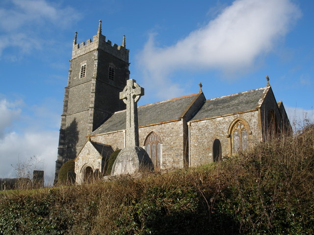
Church of St James, Iddesleigh

St James' Church, Iddesleigh, is a church in the small village of Iddesleigh, Devon, England. It dates back to the 13th century, although most of the...

River Okement

The River Okement is a tributary of the River Torridge in Devon, England. It rises at two places in Dartmoor, as the West Okement and the East Okement...

River Lew

The River Lew can refer to either of two short rivers that lie close to each other in Devon, England. The more northerly of the two rises just south of...

Meeth

Meeth is a small village roughly 13.5 km (8.4 mi) north-northwest of Okehampton and 40.7 km (25.3 mi) west-northwest of Exeter. It lies to the west of...

Meeth Halt railway station

Opened in 1925, Meeth Halt was a small railway station on the North Devon and Cornwall Junction Light Railway, a private line until it became part of the...

Dowland, Devon

Dowland is a civil parish in Devon, situated near Winkleigh. It is also the name of a hamlet in the parish. == References ==

Nearby Amenities

Located within 500m of 50.84,-4.023
Generator Method: photovoltaic
Generator Output Electricity: yes
Generator Source: solar
Generator Type: solar_photovoltaic_panel
Location: roof
Power: generator
Lat/Long: 50.8384057/-4.0232105
The data included in this document is from www.openstreetmap.org. The data is made available under ODbL.

Have you been to Ash House?

Leave your review of Ash House below (or comments, questions and feedback).