West End

Settlement in Wigtownshire

Scotland

West End

Tranquil Harbour At Stranraer, viewed from the Breastworks car park on the 12th January.
Tranquil Harbour Credit: Billy McCrorie

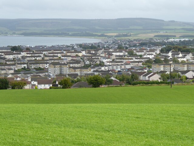
West End is a small village located in Wigtownshire, a region in the southwest of Scotland. Situated near the coast, it is part of the larger town of Stranraer and sits approximately 2 miles west of its center. With a population of around 500 residents, West End offers a peaceful and close-knit community environment.

The village is well-connected, with the A77 road passing close by, providing easy access to the surrounding areas. It is also serviced by regular bus routes, making it convenient for residents to travel to nearby towns or commute to work.

West End boasts beautiful natural surroundings, with rolling hills and breathtaking coastal views. The area attracts nature enthusiasts, who can enjoy scenic walks along the nearby Loch Ryan or explore the nearby Galloway Forest Park, which offers a variety of outdoor activities.

Local amenities in West End include a small primary school, offering education for young children in the local area. There is also a village hall, which serves as a community hub for social events and gatherings. Despite its small size, there are a few shops and services available, including a convenience store and a post office.

For additional amenities and services, residents of West End can easily access the nearby town of Stranraer, which offers a wider range of shops, supermarkets, healthcare facilities, and leisure activities.

Overall, West End provides a tranquil and picturesque place to live, with its charming community atmosphere and beautiful natural surroundings.

If you have any feedback on the listing, please let us know in the comments section below.

West End Images

Images are sourced within 2km of 54.912145/-5.042032 or Grid Reference NX0561. Thanks to Geograph Open Source API. All images are credited.

Tranquil Harbour At Stranraer, viewed from the Breastworks car park on the 12th January.
Tranquil Harbour
At Stranraer, viewed from the Breastworks car park on the 12th January.
Stranraer Harbour With the Breastworks car park on the left.
Stranraer Harbour
With the Breastworks car park on the left.
Grassland above Stranraer With the head of Loch Ryan.
Grassland above Stranraer
With the head of Loch Ryan.
A corner of the course at Stranraer Golf Club Adjacent to the A718 Stranraer to Kirkcolm road. See also <a href="https://www.geograph.org.uk/gridref/NX0363">NX0363</a>
A corner of the course at Stranraer Golf Club
Adjacent to the A718 Stranraer to Kirkcolm road. See also NX0363
Leswalt Road, Stranraer On the A718 Stranraer to Kirkcolm road
Leswalt Road, Stranraer
On the A718 Stranraer to Kirkcolm road
McCulloch's Point, Stranraer Viewed from the end of Broadstone Road.
McCulloch's Point, Stranraer
Viewed from the end of Broadstone Road.
Notice on the shores of Loch Ryan At the end of Broadstone Road, where the coastal path to McCulloch's Point starts.
Notice on the shores of Loch Ryan
At the end of Broadstone Road, where the coastal path to McCulloch's Point starts.
"Millennium Centre", George Street, Stranraer Home of Stranraer's 400 year old charter market
"Millennium Centre", George Street, Stranraer
Home of Stranraer's 400 year old charter market
West mole of Stranraer Harbour
A little beach and a lot of sealoch! At high tide, only 10 metres of beach fall into this grid square. Adjoins Broadstone Road, Stranraer. Loch Ryan in the background.
A little beach and a lot of sealoch!
At high tide, only 10 metres of beach fall into this grid square. Adjoins Broadstone Road, Stranraer. Loch Ryan in the background.
Castle of St John, Stranraer A medieval tower house dating from about 1500, in the centre of Stranraer. <span class="nowrap"><a title="http://www.dumgal.gov.uk/dumgal/MiniWeb.aspx?id=180&menuid=2805&openid=2802" rel="nofollow ugc noopener" href="http://www.dumgal.gov.uk/dumgal/MiniWeb.aspx?id=180&menuid=2805&openid=2802">Link</a><img style="margin-left:2px;" alt="External link" title="External link - shift click to open in new window" src="https://s1.geograph.org.uk/img/external.png" width="10" height="10"/></span> In the foreground are the "Tide merks", modern sculptures depicting aspects of life in Stranraer.
Castle of St John, Stranraer
A medieval tower house dating from about 1500, in the centre of Stranraer. LinkExternal link In the foreground are the "Tide merks", modern sculptures depicting aspects of life in Stranraer.
Stranraer Ferry Port Stena Line ferries to Belfast
Stranraer Ferry Port
Stena Line ferries to Belfast
Belmont Road, Stranraer Post-war development
Belmont Road, Stranraer
Post-war development
Stranraer Harbour This is shown from the waterfront between the East and West piers.  A ferry leaves for Northern Ireland.
Stranraer Harbour
This is shown from the waterfront between the East and West piers. A ferry leaves for Northern Ireland.
Train for Carlisle at Stranraer Town station. BR Standard class 4-6-0 about to depart from the former Stranraer (Town) railway station on the now closed line to Carlisle.
Train for Carlisle at Stranraer Town station.
BR Standard class 4-6-0 about to depart from the former Stranraer (Town) railway station on the now closed line to Carlisle.
Stranraer locomotive sheds. Former LMS locos await the day's roster.
Stranraer locomotive sheds.
Former LMS locos await the day's roster.
Stranraer (Harbour) station
Agricultural buildings north of Stranraer Not quite sure what they are being used for. Seen from the A718. Loch Ryan in the distance.
Agricultural buildings north of Stranraer
Not quite sure what they are being used for. Seen from the A718. Loch Ryan in the distance.
Show me another place!

West End is located at Grid Ref: NX0561 (Lat: 54.912145, Lng: -5.042032)

Unitary Authority: Dumfries and Galloway

Police Authority: Dumfries and Galloway

What 3 Words

///awaited.clasping.conquest. Near Stranraer, Dumfries & Galloway

Nearby Locations

Sheuchan Parks West End

Related Wikis

Stranraer railway station

Stranraer railway station (formerly known as Stranraer Harbour railway station) is a railway station that serves the town of Stranraer, Dumfries and Galloway...

Old Town Hall, Stranraer

The Old Town Hall is a municipal structure in George Street, Stranraer, Dumfries and Galloway, Scotland. The structure, which is used as a local history...

Castle of St John

The Castle of St John, also known as Stranraer Castle, is an early 16th-century L-plan tower house in the centre of Stranraer, in Dumfries and Galloway...

Stranraer Sheriff Court

Stranraer Sheriff Court is a judicial building in Lewis Street, Stranraer, Dumfries and Galloway, Scotland. The building, which continues to be used as...

Stranraer

Stranraer (UK: stran-RAR, in Scotland also strən-; Scottish Gaelic: An t-Sròn Reamhar [ən̪ˠ t̪ʰɾɔːn ˈɾãũ.əɾ]), also known as The Toon, is a town in Dumfries...
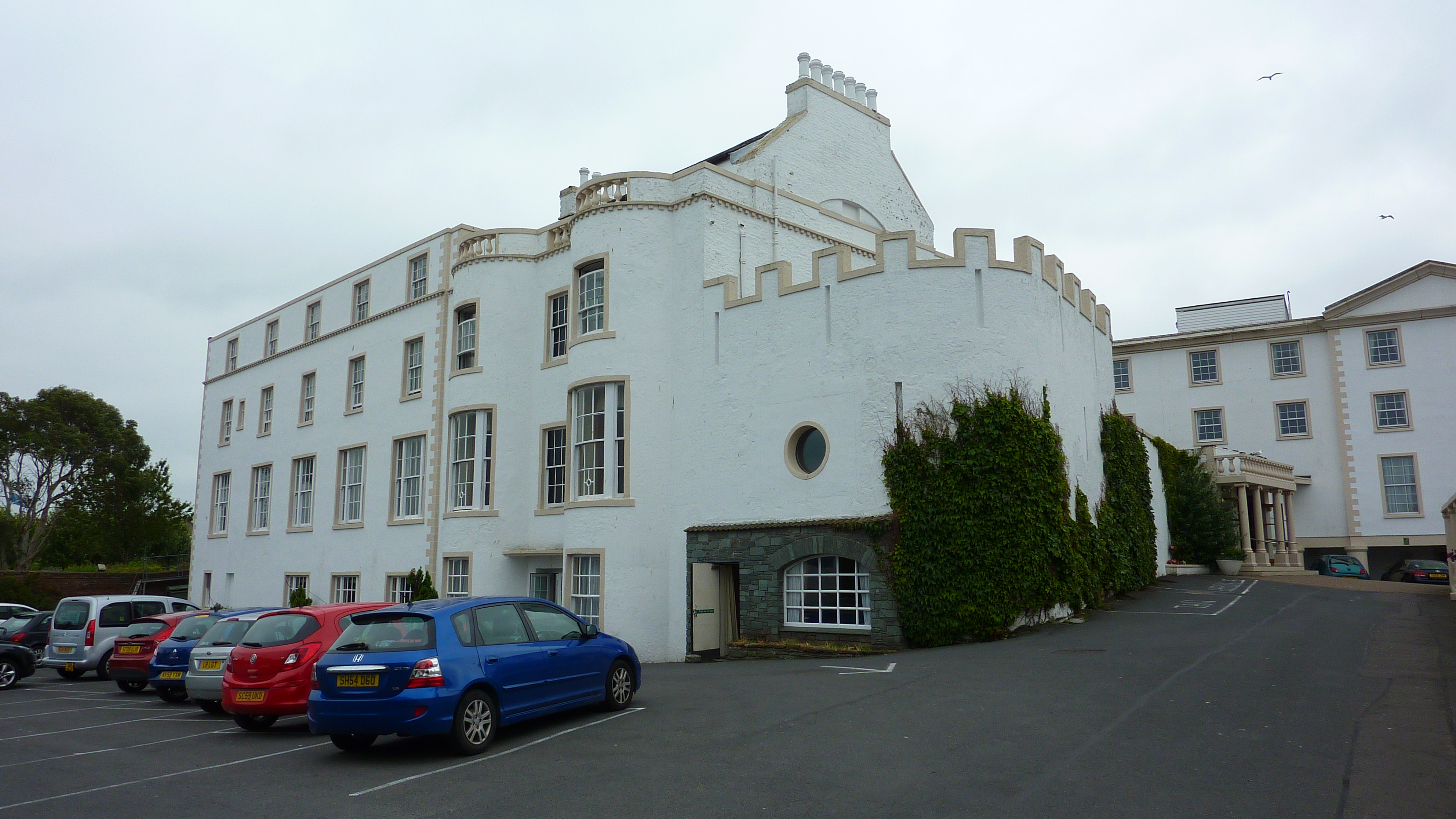
North West Castle

North West Castle is a 19th-century three star country house hotel in Stranraer, Dumfries and Galloway, in the south west of Scotland.It is noteworthy...

Galloway Community Hospital

The Galloway Community Hospital is a small hospital in Stranraer, Galloway, Scotland. It is managed by NHS Dumfries and Galloway. == History == The hospital...

Stranraer Town railway station

Stranraer Town railway station, located in Wigtownshire, Scotland, served the town of Stranraer and was a station on the Portpatrick and Wigtownshire Joint...

Nearby Amenities

Located within 500m of 54.912145,-5.042032
Source: PGS
Lat/Long: 54.9094162/-5.0362245
Source: PGS
Lat/Long: 54.9097856/-5.036361
Source: PGS
Lat/Long: 54.9103959/-5.0372252
Source: PGS
Lat/Long: 54.9107464/-5.0379803
Source: PGS
Lat/Long: 54.9109834/-5.0382149
Source: PGS
Lat/Long: 54.9112069/-5.0387782
Source: PGS
Lat/Long: 54.9114188/-5.0392103
Source: PGS
Lat/Long: 54.9116557/-5.039717
Source: PGS
Lat/Long: 54.911908/-5.0400982
Source: PGS
Lat/Long: 54.9121196/-5.040394
Source: PGS
Lat/Long: 54.9125191/-5.0409508
Source: PGS
Lat/Long: 54.9128459/-5.0413585
Source: PGS
Lat/Long: 54.9131481/-5.0417233
Source: PGS
Lat/Long: 54.9135305/-5.0422812
Source: PGS
Lat/Long: 54.9138635/-5.0426567
Source: PGS
Lat/Long: 54.9142397/-5.0430966
Created By: dmgroom_coastlines
Source: PGS
Lat/Long: 54.914731/-5.043861
Source: PGS
Lat/Long: 54.9150831/-5.044361
Source: PGS
Lat/Long: 54.9152853/-5.0445383
Source: PGS
Lat/Long: 54.9154957/-5.0444178
Source: PGS
Lat/Long: 54.9157757/-5.0447378
Source: PGS
Lat/Long: 54.9160385/-5.0450487
Bus Stop
Leswalt High Rd
Naptan AtcoCode: 680000314333
Naptan Bearing: N
Naptan CommonName: Leswalt High Rd
Naptan Indicator: opp Millbank
Naptan Landmark: Millbank Road
Naptan NaptanCode: 34234752
Naptan Notes: none
Naptan Street: Leswalt High Road
Naptan Verified: no
Source: naptan_import
Lat/Long: 54.9104464/-5.042973
Bus Stop
Leswalt High Rd
Naptan AtcoCode: 680000314444
Naptan Bearing: S
Naptan CommonName: Leswalt High Rd
Naptan Indicator: Millbank
Naptan Landmark: Millbank Road
Naptan NaptanCode: 34234737
Naptan Notes: none
Naptan Street: Leswalt High Road
Naptan Verified: no
Source: naptan_import
Lat/Long: 54.9104764/-5.0428504
Bus Stop
Millburn Court
Bus: yes
Naptan AtcoCode: 680000322333
Naptan Bearing: NW
Naptan CommonName: Millburn Court
Naptan Indicator: Road end
Naptan Landmark: Millburn Court
Naptan NaptanCode: 34234743
Naptan Notes: none
Naptan Street: Sheuchan Street
Naptan Verified: no
Public Transport: platform
Source: naptan_import
Lat/Long: 54.9105529/-5.0387208
Millburn Court
Naptan AtcoCode: 680000322444
Naptan Bearing: SE
Naptan BusStopType: CUS
Naptan CommonName: Millburn Court
Naptan Indicator: opp road end
Naptan Landmark: Millburn Court
Naptan NaptanCode: 34234735
Naptan Notes: none
Naptan Street: Sheuchan Street
Naptan Verified: no
Source: naptan_import
Lat/Long: 54.9105412/-5.0384702
Bus Stop
Larg Road
Naptan AtcoCode: 680000325501
Naptan Bearing: NE
Naptan CommonName: Larg Road
Naptan Indicator: Churchhill
Naptan Landmark: Churchhill Avenue
Naptan NaptanCode: 34234756
Naptan Notes: none
Naptan Street: Larg Road
Naptan Verified: no
Source: naptan_import
Lat/Long: 54.9138411/-5.0485044
Bus Stop
Whitehouse Rd
Naptan AtcoCode: 680000325502
Naptan Bearing: SE
Naptan CommonName: Whitehouse Rd
Naptan Indicator: opp Stoneleigh
Naptan Landmark: Larg Road
Naptan NaptanCode: 34234754
Naptan Notes: none
Naptan Street: Whitehouse Road
Naptan Verified: no
Source: naptan_import
Lat/Long: 54.9144381/-5.0472854
Bus Stop
Whitehouse Rd
Naptan AtcoCode: 680000325503
Naptan Bearing: SW
Naptan CommonName: Whitehouse Rd
Naptan Indicator: Churchhill
Naptan Landmark: Churchhill Avenue
Naptan NaptanCode: 34234753
Naptan Notes: none
Naptan Street: Whitehouse Road
Naptan Verified: no
Source: naptan_import
Lat/Long: 54.9130997/-5.0452266
Bus Stop
Leswalt Road
Naptan AtcoCode: 680000325504
Naptan Bearing: NE
Naptan CommonName: Leswalt Road
Naptan Indicator: Whitehouse
Naptan Landmark: Whitehouse Road
Naptan NaptanCode: 34234826
Naptan Notes: none
Naptan Street: Leswalt Road
Naptan Verified: no
Source: naptan_import
Lat/Long: 54.9123199/-5.0453461
Whitehouse Rd
Naptan AtcoCode: 680000325506
Naptan Bearing: NW
Naptan BusStopType: CUS
Naptan CommonName: Whitehouse Rd
Naptan Indicator: Stoneleigh
Naptan NaptanCode: 34238758
Naptan Street: Whitehouse Road
Naptan Verified: no
Source: naptan_import
Lat/Long: 54.9143441/-5.047091
Bus Stop
West End Terr
Bus: yes
Naptan AtcoCode: 680000326333
Naptan Bearing: NW
Naptan CommonName: West End Terr
Naptan Indicator: opp Terr
Naptan Landmark: Leswalt High Road
Naptan NaptanCode: 34234736
Naptan Notes: none
Naptan Street: Sheuchan Street
Naptan Verified: no
Public Transport: platform
Source: naptan_import
Lat/Long: 54.9116865/-5.0428471
Bus Stop
Springbank Rd
Naptan AtcoCode: 680000738444
Naptan Bearing: SW
Naptan CommonName: Springbank Rd
Naptan Indicator: Sibbaldbie
Naptan Landmark: Brook Crescent
Naptan NaptanCode: 34234738
Naptan Notes: none
Naptan Street: Springbank Road
Naptan Verified: no
Source: naptan_import
Lat/Long: 54.908906/-5.0441675
Bus Stop
Leswalt Road
Naptan AtcoCode: 680004025444
Naptan Bearing: NW
Naptan BusStopType: CUS
Naptan CommonName: Leswalt Road
Naptan Indicator: Meadowbank
Naptan NaptanCode: 34238768
Naptan Street: Leswalt Road
Naptan Verified: yes
Shelter: yes
Source: naptan_import
Lat/Long: 54.9126696/-5.0464444
Noexit: yes
Lat/Long: 54.9126283/-5.0464358
Street Lamp
Lat/Long: 54.9118351/-5.043767
Bench
Lat/Long: 54.9117702/-5.0437157
Bench
Lat/Long: 54.911715/-5.043674
Street Lamp
Lat/Long: 54.9116926/-5.0435887
Street Lamp
Lat/Long: 54.9118819/-5.0434224
Give Way
Direction: backward
Lat/Long: 54.9117832/-5.0434305
Post Box
Brand: Royal Mail
Brand Wikidata: Q638098
Collection Times: Mo-Fr 09:00; Sa 07:00
Operator: Royal Mail
Operator Wikidata: Q638098
Post Box Type: lamp
Ref: DG9 7D
Royal Cypher: scottish_crown
Source: survey
Lat/Long: 54.9095218/-5.0371028
Generator Method: photovoltaic
Generator Output Electricity: yes
Generator Source: solar
Generator Type: solar_photovoltaic_panel
Power: generator
Lat/Long: 54.9099282/-5.0402503
Generator Method: photovoltaic
Generator Output Electricity: yes
Generator Source: solar
Generator Type: solar_photovoltaic_panel
Power: generator
Lat/Long: 54.9095433/-5.039584
Generator Method: photovoltaic
Generator Output Electricity: yes
Generator Source: solar
Generator Type: solar_photovoltaic_panel
Power: generator
Lat/Long: 54.909299/-5.0392058
Generator Method: photovoltaic
Generator Output Electricity: yes
Generator Source: solar
Generator Type: solar_photovoltaic_panel
Power: generator
Lat/Long: 54.909354/-5.0391848
Source: PGS
Lat/Long: 54.9092928/-5.0363452
Source: PGS
Lat/Long: 54.9092928/-5.0363452
Power: pole
Lat/Long: 54.9085298/-5.0451338
Power: pole
Lat/Long: 54.9094502/-5.0477854
Power: pole
Lat/Long: 54.9096256/-5.0470036
The data included in this document is from www.openstreetmap.org. The data is made available under ODbL.

Have you been to West End?

Leave your review of West End below (or comments, questions and feedback).