The Dock

Settlement in Ross-shire

Scotland

The Dock

Masonic Hall, George Street, Avoch
Masonic Hall, George Street, Avoch Credit: Bill Harrison

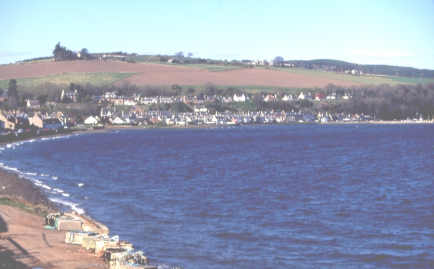
The Dock is a small coastal village located in Ross-shire, Scotland. Situated on the eastern coast of the Black Isle peninsula, it overlooks the stunning waters of the Cromarty Firth. The village is nestled between the larger towns of Invergordon and Cromarty, offering residents and visitors a peaceful and picturesque retreat.

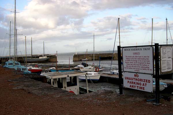
The Dock is renowned for its rich maritime heritage, with a history deeply rooted in fishing and shipping. The village's name itself signifies its significance as a bustling harbor in the past. Today, remnants of the old dock and pier can still be seen, serving as a reminder of its vibrant maritime past.

Despite its small size, The Dock attracts nature enthusiasts and outdoor lovers with its breathtaking scenery. The surrounding area is teeming with wildlife, including various species of birds and marine life. A leisurely stroll along the coast provides visitors with panoramic views of the firth, while also offering a chance to spot seals, dolphins, and even the occasional whale.

The village boasts a close-knit community, with friendly locals who take pride in their tranquil seaside haven. The Dock is home to a handful of small businesses, including a charming local pub and a seafood restaurant that serves freshly caught delicacies.

For those seeking a tranquil escape from the bustling city life, The Dock is the perfect destination. Its idyllic coastal setting, rich history, and warm community make it a hidden gem in the heart of Ross-shire.

If you have any feedback on the listing, please let us know in the comments section below.
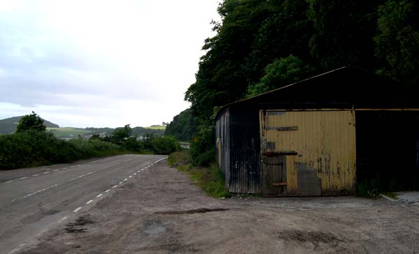
The Dock Images

Images are sourced within 2km of 57.565775/-4.1713458 or Grid Reference NH7054. Thanks to Geograph Open Source API. All images are credited.

Masonic Hall, George Street, Avoch
Public artwork, Avoch
Eco house in the forest
Track through Knockmuir Wood
Minor road to Killen
Houses on Mackay Terrace, Avoch
Round the bend... ...on School Brae, Avoch.
Round the bend...
...on School Brae, Avoch.
Entering the Rosehaugh Estate, Avoch
Springtime walk on the Rosehaugh Estate
Fields to the west of Avoch
Walking the Upper Drive, Rosehaugh Estate
Long-distance view of Arkendieth Farm The Canmore listing notes the remains of a tower (13558 <span class="nowrap"><a title="https://canmore.org.uk/site/13558/arkendeith-tower" rel="nofollow ugc noopener" href="https://canmore.org.uk/site/13558/arkendeith-tower">Link</a><img style="margin-left:2px;" alt="External link" title="External link - shift click to open in new window" src="https://s1.geograph.org.uk/img/external.png" width="10" height="10"/></span> ).
Long-distance view of Arkendieth Farm
The Canmore listing notes the remains of a tower (13558 LinkExternal link ).
Beech wood beside Avoch Burn
Fish Farming at Avoch A tank of salmon hatchlings is airlifted by helicopter to the pens in Avoch Bay
Fish Farming at Avoch
A tank of salmon hatchlings is airlifted by helicopter to the pens in Avoch Bay
Avoch A fishing village on the Black Isle.
Avoch
A fishing village on the Black Isle.
Avoch War Memorial Looking up the A832 as it leaves Avoch (which is pronounced 'Och').
Avoch War Memorial
Looking up the A832 as it leaves Avoch (which is pronounced 'Och').
Avoch Harbour There has been a harbour in Avoch (pronounced 'Och') since the 15th century.
Avoch Harbour
There has been a harbour in Avoch (pronounced 'Och') since the 15th century.
Roads department shed Dilapidated building beside A832 between Avoch and Fortrose.
Roads department shed
Dilapidated building beside A832 between Avoch and Fortrose.
Show me another place!

The Dock is located at Grid Ref: NH7054 (Lat: 57.565775, Lng: -4.1713458)

Unitary Authority: Highland

Police Authority: Highlands and Islands

What 3 Words

///bearable.ants.screeches. Near Fortrose, Highland

Related Wikis

Avoch

Avoch ( OKH; from the Scottish Gaelic: Abhach – meaning mouth of the stream) is a harbour-village located on the south-east coast of the Black Isle, on...

Avoch railway station

Avoch railway station was a station on the single track branch of the Highland Railway, in north east Scotland. The line connected villages in The Black...

Ormond Castle

Ormond Castle, also known as Avoch Castle, was a powerful stronghold, overlooking the village of Avoch, on the Black Isle, in the former county of Ross...

Rosehaugh House

Rosehaugh House was an estate located near the village of Avoch in the Highland council area of Scotland. It consisted of a manor house, gardens, parkland...

Nearby Amenities

Located within 500m of 57.565775,-4.1713458
Source: PGS
Lat/Long: 57.5622906/-4.1752548
Source: PGS
Lat/Long: 57.5632939/-4.1745303
Source: PGS
Lat/Long: 57.5635151/-4.1742438
Source: PGS
Lat/Long: 57.564192/-4.1738546
Source: PGS
Lat/Long: 57.5646597/-4.1732885
Source: PGS
Lat/Long: 57.564777/-4.1729037
Source: PGS
Lat/Long: 57.5649455/-4.1726114
Source: PGS
Lat/Long: 57.5650812/-4.1723693
Source: PGS
Lat/Long: 57.5652738/-4.17212
Source: PGS
Lat/Long: 57.5654277/-4.1718633
Source: PGS
Lat/Long: 57.5656213/-4.1715287
Source: PGS
Lat/Long: 57.5657081/-4.1713004
Source: PGS
Lat/Long: 57.5657698/-4.1708651
Source: PGS
Lat/Long: 57.5660185/-4.1705184
Source: PGS
Lat/Long: 57.5663871/-4.1699165
Source: PGS
Lat/Long: 57.5664656/-4.1697676
Source: PGS
Lat/Long: 57.5667619/-4.1677438
Source: PGS
Lat/Long: 57.5667788/-4.1676339
Source: PGS
Lat/Long: 57.5664169/-4.1668975
Source: PGS
Lat/Long: 57.5665244/-4.1660811
Source: PGS
Lat/Long: 57.5666995/-4.1657262
Source: PGS
Lat/Long: 57.5668371/-4.165499
Source: PGS
Lat/Long: 57.5670701/-4.1654593
Source: PGS
Lat/Long: 57.5670696/-4.1655039
Source: PGS
Lat/Long: 57.567461/-4.1668454
Source: PGS
Lat/Long: 57.5679274/-4.1653349
Avoch
Name Gd: Abhach
Name Sco: Auch
Place: village
Population: 1000
Wikidata: Q1011342
Wikipedia: en:Avoch
Lat/Long: 57.5669032/-4.1709352
Atm
Opening Hours: 24/7
Wheelchair: yes
Lat/Long: 57.5673076/-4.1716974
steps top
Ele: 0
Lat/Long: 57.5676213/-4.1702608
Toilets
Check Date: 2023-07-23
Lat/Long: 57.5672061/-4.1681019
Post Box
Collection Times: Mo-Fr 10:30; Sa 10:30
Operator: Royal Mail
Post Box Type: lamp
Ref: IV9 185
Source: survey
Lat/Long: 57.5686917/-4.1759022
Historic: memorial
Memorial: obelisk
Lat/Long: 57.5670234/-4.1772079
Scotmid
Addr City: Avoch
Addr Housenumber: 37
Addr Postcode: IV9 8PT
Brand: Scotmid
Brand Wikidata: Q7435719
Brand Wikipedia: en:Scotmid
Operator: Scottish Midland Co-operative Society
Shop: convenience
Website: https://scotmid.coop/store/avoch/
Lat/Long: 57.5672688/-4.1718564
Station Hotel
Tourism: hotel
Lat/Long: 57.5672288/-4.1731335
Parking
Lat/Long: 57.5670543/-4.1727276
Telephone
Booth: KX100
Covered: booth
Phone: +44 1381 620226
Source: survey
Lat/Long: 57.5674844/-4.17283
Post Box
Collection Times: Mo-Fr 16:30; Sa 13:00
Operator: Royal Mail
Post Box Type: pillar
Ref: IV9 130
Royal Cypher: scottish_crown
Source: survey
Lat/Long: 57.5671728/-4.1692139
Fast Food
Jasmine Garden
Cuisine: chinese
Source: survey
Lat/Long: 57.5672506/-4.1715132
Crossing
Crossing: uncontrolled
Crossing Island: no
Lat/Long: 57.5673677/-4.1719012
Place Of Worship
Avoch Congregational Church
Phone: +44 1381 620225
Religion: christian
Lat/Long: 57.5675003/-4.1718273
Bus Stop
Avoch Hotel
Bench: yes
Bus: yes
Naptan AtcoCode: 670061018
Naptan Bearing: E
Naptan CommonName: Avoch Hotel
Naptan Indicator: opp
Naptan Landmark: Avoch Hotel
Naptan NaptanCode: 45324569
Naptan Street: High Street
Naptan Verified: no
Public Transport: platform
Shelter: yes
Source: naptan_import
Lat/Long: 57.5674776/-4.1725664
Bus Stop
Avoch Hotel
Bench: yes
Bin: yes
Bus: yes
Naptan AtcoCode: 670061019
Naptan Bearing: W
Naptan CommonName: Avoch Hotel
Naptan Indicator: o/s
Naptan Landmark: School Brae
Naptan NaptanCode: 45324568
Naptan Street: High Street
Naptan Verified: no
Public Transport: platform
Shelter: yes
Source: naptan_import
Tactile Paving: no
Lat/Long: 57.5673521/-4.1727345
Bus Stop
Harbour
Bench: yes
Bin: yes
Naptan AtcoCode: 670061020
Naptan Bearing: W
Naptan CommonName: Harbour
Naptan Indicator: adj
Naptan Landmark: Avoch Harbour
Naptan NaptanCode: 45324567
Naptan Street: A832
Naptan Verified: no
Shelter: yes
Source: naptan_import
Lat/Long: 57.5674176/-4.1673348
Bus Stop
Post Office
Naptan AtcoCode: 670061020A
Naptan Bearing: E
Naptan CommonName: Post Office
Naptan Indicator: opp
Naptan Landmark: Post Office
Naptan NaptanCode: 45324565
Naptan Street: High Street
Naptan Verified: no
Source: naptan_import
Lat/Long: 57.5672536/-4.1692551
Bus Stop
Primary School
Naptan AtcoCode: 6700713423
Naptan Bearing: SE
Naptan CommonName: Primary School
Naptan Indicator: o/s
Naptan Landmark: Primary School
Naptan NaptanCode: 45328724
Naptan Street: School Road
Naptan Verified: no
Source: naptan_import
Lat/Long: 57.5680986/-4.1767441
Man Made: beacon
Seamark Light Category: vertical
Seamark Light Character: F
Seamark Light Colour: red
Seamark Light Height: 7
Seamark Light Multiple: 2
Seamark Light Range: 5
Seamark Light Reference: A 3442
Seamark Type: light_minor
Source: US NGA Pub. 114. 2011-05-26.
Lat/Long: 57.5670096/-4.1654188
Description: Steel sails near public art bus shelter with roof like upturned boat with bricks inscribed by local people.
Tourism: artwork
Lat/Long: 57.567457/-4.1727784
Pub
Station Hotel Avoch
Lat/Long: 57.5672744/-4.1729558
Avoch Bay
Natural: bay
Source: OS OpenData Streetview
Lat/Long: 57.5616001/-4.1732196
Waste Basket
Source: gps survey
Lat/Long: 57.5636752/-4.1744498
Post Box
Collection Times: Mo-Sa 10:00
Operator: Royal Mail
Post Box Type: lamp
Ref: IV9 166
Source: survey
Lat/Long: 57.5632292/-4.1747529
Bench
Source: gps survey
Lat/Long: 57.5661886/-4.1705116
Bench
Source: gps survey
Lat/Long: 57.566231/-4.1704486
Bench
Source: gps survey
Lat/Long: 57.5664453/-4.1700141
Bench
Source: gps survey
Lat/Long: 57.5667648/-4.1698918
Burnside Garage
Shop: car_repair
Source: Local knowledge
Lat/Long: 57.5668253/-4.1747336
Post Office
Avoch Post Office
Addr Postcode: IV9 8PT
Branch: Avoch
Brand: Post Office
Brand Wikidata: Q1783168
Check Date: 2020-02-20
Contact Website: https://www.postoffice.co.uk/branch-finder/1038400/avoch
Ref Pol Id: 1350
Source: survey
Lat/Long: 57.5671526/-4.1703607
Bicycle Parking
Bicycle Parking: stands
Capacity: 4
Source: Local knowledge - Million Miles project
Lat/Long: 57.5673098/-4.1720371
Bicycle Parking
Bicycle Parking: stands
Capacity: 4
Source: Local knowledge - Transition Black Isle's Million Miles project
Lat/Long: 57.5672235/-4.1679843
Black Isle Barbers
Shop: hairdresser
Lat/Long: 57.567141/-4.1693186
Fast Food
Harbour
Cuisine: burger;fish_and_chips;kebab;pizza
Lat/Long: 57.5671427/-4.1692369
Brenda May's
Shop: hairdresser
Lat/Long: 57.5672875/-4.1692968
Avoch Bay
Natural: bay
Lat/Long: 57.5640429/-4.1647217
Give Way
Direction: forward
Lat/Long: 57.5657132/-4.1725712
Give Way
Direction: backward
Lat/Long: 57.5660011/-4.1713397
Give Way
Direction: forward
Lat/Long: 57.5660692/-4.1713495
Give Way
Direction: backward
Lat/Long: 57.5667652/-4.1698001
Give Way
Direction: forward
Lat/Long: 57.5664152/-4.1704489
Power: pole
Lat/Long: 57.5695457/-4.1740275
Power: pole
Lat/Long: 57.5695501/-4.1738977
Power: pole
Lat/Long: 57.5698504/-4.173088
Power: pole
Lat/Long: 57.5701486/-4.1722885
Fast Food
Gabi's Tandoori
Cuisine: indian
Lat/Long: 57.5671026/-4.172046
Entrance: yes
Lat/Long: 57.5673063/-4.1719864
Defibrillator
Defibrillator Location: on the outside wall
Emergency: defibrillator
Indoor: no
Level: 0
Opening Hours: 24/7
Lat/Long: 57.5672954/-4.1719951
The data included in this document is from www.openstreetmap.org. The data is made available under ODbL.

Have you been to The Dock?

Leave your review of The Dock below (or comments, questions and feedback).