Achmore

Settlement in Ross-shire

Scotland

Achmore

Carnach Little Loch Broom Viewed from the viewpoint on the A832 at Druim nam Fuath
Carnach Little Loch Broom Credit: valenta

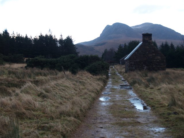
Achmore is a small village located in the region of Ross-shire, situated in the Scottish Highlands of Scotland. It is situated approximately 10 miles northwest of the town of Dingwall. The village is nestled in a picturesque landscape, surrounded by rolling hills and scenic countryside.

With a population of around 200 residents, Achmore offers a peaceful and close-knit community atmosphere. The village primarily consists of traditional stone houses and cottages, adding to its charming and authentic character. Many of the properties have stunning views of the nearby Loch Achilty, adding to the overall appeal of the area.

Despite its small size, Achmore benefits from a few local amenities. There is a primary school within the village, providing education for the local children. For further amenities, residents can easily access nearby towns such as Dingwall, where they can find additional schools, shops, and services.

Achmore is an ideal location for outdoor enthusiasts, with ample opportunities for walking, hiking, and cycling in the surrounding countryside. Loch Achilty is popular for fishing and boating activities, attracting enthusiasts from near and far. The village is also within easy reach of several Munros (Scottish mountains over 3,000 feet), offering stunning views and challenging climbs for experienced hikers.

In summary, Achmore is a tranquil and scenic village in Ross-shire, offering a close-knit community, beautiful surroundings, and a range of outdoor activities for residents and visitors to enjoy.

If you have any feedback on the listing, please let us know in the comments section below.

Achmore Images

Images are sourced within 2km of 57.915374/-5.337932 or Grid Reference NH0296. Thanks to Geograph Open Source API. All images are credited.

Carnach Little Loch Broom Viewed from the viewpoint on the A832 at Druim nam Fuath
Carnach Little Loch Broom
Viewed from the viewpoint on the A832 at Druim nam Fuath
Carnach Little Loch Broom Viewed from the viewpoint on the A832 at Druim nam Fuath
Carnach Little Loch Broom
Viewed from the viewpoint on the A832 at Druim nam Fuath
Scoraig from A832 above Badcaul The viewpoint or car park this picture is taken from was the location of the purpose built garage for the filming of the 2011/2 film 'Shell', an independent Scottish drama film directed by Scott Graham.
Scoraig from A832 above Badcaul
The viewpoint or car park this picture is taken from was the location of the purpose built garage for the filming of the 2011/2 film 'Shell', an independent Scottish drama film directed by Scott Graham.
on the moors above Scoraig home to a herd of abandoned goats
on the moors above Scoraig
home to a herd of abandoned goats
Play area of Scoraig Primary School Note the wind turbine. Scoraig is 'off grid' and householders and businesses rely heavily on the wind for electrical power.
Play area of Scoraig Primary School
Note the wind turbine. Scoraig is 'off grid' and householders and businesses rely heavily on the wind for electrical power.
Looking towards Bidean a Ghlas Thuill from Rireavach The track you see narrows to a single-file path. This is the only land route to the peninsula.
Looking towards Bidean a Ghlas Thuill from Rireavach
The track you see narrows to a single-file path. This is the only land route to the peninsula.
Shoreline, Carnach This square is mainly sea - part of Little Loch Broom.  Looking towards Beinn Ghoblach in the distance.
Shoreline, Carnach
This square is mainly sea - part of Little Loch Broom. Looking towards Beinn Ghoblach in the distance.
Old Street, Scoraig Despite the many inhabited areas in this remote peninsula, this street seems abandoned.  Looking towards Beinn Ghoblach.
Old Street, Scoraig
Despite the many inhabited areas in this remote peninsula, this street seems abandoned. Looking towards Beinn Ghoblach.
Main road, Carnach Part of the isolated Scoraig peninsula, this square is mostly sea-loch, with a bit of coastline and around 100m of the "main road" connecting the pier at Scoraig with Rireavach.  Looking towards Beinn Ghoblach on the left.
Main road, Carnach
Part of the isolated Scoraig peninsula, this square is mostly sea-loch, with a bit of coastline and around 100m of the "main road" connecting the pier at Scoraig with Rireavach. Looking towards Beinn Ghoblach on the left.
The lighthouse, Scoraig. No longer in operation, and moved from its original site, this structure has been preserved as a "feature".
The lighthouse, Scoraig.
No longer in operation, and moved from its original site, this structure has been preserved as a "feature".
Path to Badrallach, Scoraig This square is mostly sea-loch (Little Loch Broom), but has a small triangle of coastline and a small part of the path between Scoraig and Badrallach.  Looking towards the head of the loch.
Path to Badrallach, Scoraig
This square is mostly sea-loch (Little Loch Broom), but has a small triangle of coastline and a small part of the path between Scoraig and Badrallach. Looking towards the head of the loch.
Tea shop, Rireavach A rather isolated facility, to reach it from a public road involves a boat crossing of Little Loch Broom or a walk of 8km from Badrallach.
Tea shop, Rireavach
A rather isolated facility, to reach it from a public road involves a boat crossing of Little Loch Broom or a walk of 8km from Badrallach.
Ruined crofts, Rireavach The wind turbine shows there are other, still inhabited dwellings nearby.
Ruined crofts, Rireavach
The wind turbine shows there are other, still inhabited dwellings nearby.
Turfed thatched croft,  Rireavach A small but well-maintained dwelling in the isolated community of Rireavach.
Turfed thatched croft, Rireavach
A small but well-maintained dwelling in the isolated community of Rireavach.
Sandstone boulders, Rireavach A small outcrop of Torridonian sandstone amongst the heather.  Above is a small plantation of young trees.
Sandstone boulders, Rireavach
A small outcrop of Torridonian sandstone amongst the heather. Above is a small plantation of young trees.
Achmore from Beinn Ghoblach
Creagan Ruadh, Annat Bay, Loch Broom Despite its dramatic appearance the coastal feature of Creagan Ruadh offers a very average dive with the bedrock cliff disappearing into sandy mud at a depth of only fifteen metres.
Creagan Ruadh, Annat Bay, Loch Broom
Despite its dramatic appearance the coastal feature of Creagan Ruadh offers a very average dive with the bedrock cliff disappearing into sandy mud at a depth of only fifteen metres.
Moorland bog near Beinn Ghobhlach With Ben Mor Coigach in the background
Moorland bog near Beinn Ghobhlach
With Ben Mor Coigach in the background
Show me another place!

Achmore is located at Grid Ref: NH0296 (Lat: 57.915374, Lng: -5.337932)

Unitary Authority: Highland

Police Authority: Highlands and Islands

What 3 Words

///campsites.agreeable.explores. Near Ullapool, Highland

Nearby Locations

Achmore

Related Wikis

Carnach

Carnach (Scottish Gaelic: Càrnach) is a remote hamlet on the north west shore of Little Loch Broom in Ross-shire, Scottish Highlands and is in the Scottish...

Scoraig

Scoraig (Scottish Gaelic: Sgoraig) is a settlement located on a remote peninsula between Little Loch Broom and Loch Broom, north-west of Ullapool in Ross...

Beinn Ghobhlach

Beinn Ghiobhlach (Scottish Gaelic for 'forked mountain') is a mountain with a height of 635 metres (2,083 ft) in the Northwest Highlands of Scotland. It...

Badluarach

Badluarach (Scottish Gaelic: Am Bad Luachrach) is a small village on the south shore of Little Loch Broom, in Wester Ross in the Highland council area...

Nearby Amenities

Located within 500m of 57.915374,-5.337932
Source: PGS
Lat/Long: 57.9144422/-5.3301893
Source: PGS
Lat/Long: 57.9146783/-5.3309717
Source: PGS
Lat/Long: 57.9148175/-5.3314143
Created By: almien_coastlines
Source: PGS
Lat/Long: 57.915044/-5.331955
Source: PGS
Lat/Long: 57.9158705/-5.3326101
Source: PGS
Lat/Long: 57.9163966/-5.3328949
Source: PGS
Lat/Long: 57.917077/-5.3326786
Source: PGS
Lat/Long: 57.9174862/-5.3333401
Source: PGS
Lat/Long: 57.917668/-5.3338963
Created By: almien_coastlines
Source: PGS
Lat/Long: 57.918074/-5.334317
Created By: almien_coastlines
Source: PGS
Lat/Long: 57.918576/-5.334831
Source: PGS
Lat/Long: 57.918701/-5.3356141
Source: PGS
Lat/Long: 57.9185492/-5.3362258
Created By: almien_coastlines
Source: PGS
Lat/Long: 57.918417/-5.336505
Source: PGS
Lat/Long: 57.918255/-5.33686
Source: PGS
Lat/Long: 57.9186951/-5.3384412
Source: PGS
Lat/Long: 57.9188006/-5.338365
Source: PGS
Lat/Long: 57.9186286/-5.3393273
Source: PGS
Lat/Long: 57.9191515/-5.3395612
Source: PGS
Lat/Long: 57.9191397/-5.3399162
Source: PGS
Lat/Long: 57.9194267/-5.3411833
Achmore
Name Gd: An t-Achadh Mòr
Place: hamlet
Lat/Long: 57.9167512/-5.3376216
Càrn an Achaidh Mhòir
Natural: peak
Lat/Long: 57.912439/-5.3418819
The data included in this document is from www.openstreetmap.org. The data is made available under ODbL.

Have you been to Achmore?

Leave your review of Achmore below (or comments, questions and feedback).