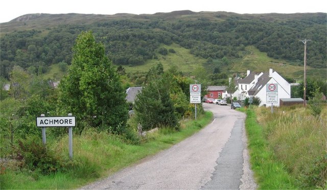
Achmore

Settlement in Ross-shire

Scotland

Achmore

Stromemore from Strome Ferry In 1966 the A890, used this route, via the ferry to continue its way North.
Stromemore from Strome Ferry Credit: Peter Jeffery

Achmore is a small village located in Ross-shire, a county in the Scottish Highlands of Scotland. Situated in the northwest of the country, Achmore is nestled amidst breathtaking natural beauty, with its picturesque surroundings making it an ideal place for nature enthusiasts and outdoor lovers.

The village is surrounded by rolling hills and vast open landscapes, offering spectacular views of the Scottish Highlands. Its location near Loch Carron provides opportunities for various water activities such as fishing, boating, and kayaking. The area is also known for its diverse wildlife, including red deer, golden eagles, and otters.

Achmore is a close-knit community, with a population of around 150 people. The village boasts a friendly and welcoming atmosphere, making it a charming place to visit or reside. It offers a peaceful and quiet environment, perfect for those seeking relaxation and tranquility.

Despite its small size, Achmore offers some amenities for its residents and visitors. It has a local pub where people can gather and socialize, and a small convenience store for basic necessities. The nearest town, Kyle of Lochalsh, is approximately 20 miles away, providing additional services and amenities.

Achmore is a hidden gem in the Scottish Highlands, offering a unique opportunity to experience the beauty and serenity of rural Scotland. Its natural surroundings, friendly community, and peaceful atmosphere make it a destination worth exploring for those seeking a break from the hustle and bustle of city life.

If you have any feedback on the listing, please let us know in the comments section below.

Achmore Images

Images are sourced within 2km of 57.341741/-5.564825 or Grid Reference NG8533. Thanks to Geograph Open Source API. All images are credited.

Stromemore from Strome Ferry In 1966 the A890, used this route, via the ferry to continue its way North.
Stromemore from Strome Ferry
In 1966 the A890, used this route, via the ferry to continue its way North.
Track junction and store in South Strome forest
Footbridge, by Fernaig This wooden bridge crosses the Abhainn Srath Ascaig, next to the farm at Fernaig. The bridge now seems to be in poor condition, rotten in places, but it is possible to walk across carefully.

The OS maps show this bridge connected to a path at the southern end, along with several nearby bridges over the Allt a' Mhuillin, but that didn't seem to be very obvious on the ground.
Footbridge, by Fernaig
This wooden bridge crosses the Abhainn Srath Ascaig, next to the farm at Fernaig. The bridge now seems to be in poor condition, rotten in places, but it is possible to walk across carefully. The OS maps show this bridge connected to a path at the southern end, along with several nearby bridges over the Allt a' Mhuillin, but that didn't seem to be very obvious on the ground.
Old Stromeferry Hotel This hotel dates from 1874, but has been disused for a number of years. It was damaged by a fire in 1993. Since then there have been several proposals for renovating the building, and some repair work was done. But that seems to have stopped, and it is now derelict.

The hotel features in Iain Banks' novel 'Complicity'.

It is listed on the Buildings at Risk Register for Scotland. <span class="nowrap"><a title="http://www.buildingsatrisk.org.uk/details/895926" rel="nofollow ugc noopener" href="http://www.buildingsatrisk.org.uk/details/895926">Link</a><img style="margin-left:2px;" alt="External link" title="External link - shift click to open in new window" src="https://s1.geograph.org.uk/img/external.png" width="10" height="10"/></span>
Old Stromeferry Hotel
This hotel dates from 1874, but has been disused for a number of years. It was damaged by a fire in 1993. Since then there have been several proposals for renovating the building, and some repair work was done. But that seems to have stopped, and it is now derelict. The hotel features in Iain Banks' novel 'Complicity'. It is listed on the Buildings at Risk Register for Scotland. LinkExternal link
View over Loch Carron A view along the length of Loch Carron, from beside the A890 road, near Stromeferry. With a mixture of trees growing on the slopes below, including plenty of birch and larch.
View over Loch Carron
A view along the length of Loch Carron, from beside the A890 road, near Stromeferry. With a mixture of trees growing on the slopes below, including plenty of birch and larch.
Stromeferry railway station Quite a long platform, for what is now a not very busy station. Looking west along the line, towards Plockton and Kyle of Lochalsh. With a boat on a trailer just beside the station.

Stromeferry station has been much busier in the past, with several platforms, sidings, a goods shed and connections for ships at the pier.
Stromeferry railway station
Quite a long platform, for what is now a not very busy station. Looking west along the line, towards Plockton and Kyle of Lochalsh. With a boat on a trailer just beside the station. Stromeferry station has been much busier in the past, with several platforms, sidings, a goods shed and connections for ships at the pier.
Sign for Port an t-Sròim / Stromeferry (No ferry) A road sign on the A890, for the junction to Stromeferry, or Port an t-Sròim in Gaelic.
The "No ferry" message has reappeared - it wasn't on the sign last year. I'm not sure if that is an 'official' modification. <a href="https://www.geograph.org.uk/photo/4417841">NG8634 : Stromeferry No "No Ferry"</a>
Sign for Port an t-Sròim / Stromeferry (No ferry)
A road sign on the A890, for the junction to Stromeferry, or Port an t-Sròim in Gaelic. The "No ferry" message has reappeared - it wasn't on the sign last year. I'm not sure if that is an 'official' modification. NG8634 : Stromeferry No "No Ferry"
Station at Stromeferry I always liked the road signs to this tiny place which always point to "Stromeferry (no ferry)".  The last car-ferry across Loch Carron ceased in 1970.  However, in 2012 a landslide closed the main A890 and a passenger ferry and a car ferry were briefly re-introduced to help alleviate the serious transport problems caused.
Station at Stromeferry
I always liked the road signs to this tiny place which always point to "Stromeferry (no ferry)". The last car-ferry across Loch Carron ceased in 1970. However, in 2012 a landslide closed the main A890 and a passenger ferry and a car ferry were briefly re-introduced to help alleviate the serious transport problems caused.
North Strome slipway
Loch Carron shore at Stromeferry
Stromeferry and Loch Carron
General view of square Looking NE.
Loch Carron just visible at top left of photo.
General view of square
Looking NE. Loch Carron just visible at top left of photo.
Strome Castle, Loch Carron Not a lot left, but the history is here; <span class="nowrap"><a title="https://en.wikipedia.org/wiki/Strome_Castle" rel="nofollow ugc noopener" href="https://en.wikipedia.org/wiki/Strome_Castle">Link</a><img style="margin-left:2px;" alt="External link" title="External link - shift click to open in new window" src="https://s1.geograph.org.uk/img/external.png" width="10" height="10"/></span>
Strome Castle, Loch Carron
Not a lot left, but the history is here; LinkExternal link
Minor road, Strath Ascaig
The old slipway, North Strome Before the road from Strome Ferry to Strathcarron was opened in 1970, this was the ferry crossing on the road north.
The old slipway, North Strome
Before the road from Strome Ferry to Strathcarron was opened in 1970, this was the ferry crossing on the road north.
Strome Castle In the late 16th century the castle was held by the Macdonalds of Glengarry but the neighbouring Mackenzies disputed possession and in 1602 laid siege. By accident, water was poured into the gunpowder casks. Learning of this, the  Mackenzies allowed the Macdonalds to surrender and evacuate the castle which was then blown up. (Source: information board nearby - also see <span class="nowrap"><a title="http://www.undiscoveredscotland.co.uk/lochcarron/stromecastle/" rel="nofollow ugc noopener" href="http://www.undiscoveredscotland.co.uk/lochcarron/stromecastle/">Link</a><img style="margin-left:2px;" alt="External link" title="External link - shift click to open in new window" src="https://s1.geograph.org.uk/img/external.png" width="10" height="10"/></span> )
Strome Castle
In the late 16th century the castle was held by the Macdonalds of Glengarry but the neighbouring Mackenzies disputed possession and in 1602 laid siege. By accident, water was poured into the gunpowder casks. Learning of this, the Mackenzies allowed the Macdonalds to surrender and evacuate the castle which was then blown up. (Source: information board nearby - also see LinkExternal link )
Port a' Mheirlich A small bay on the N side of the narrows in Loch Carron. Across the water is Creag an t-Sroilleachan.
Port a' Mheirlich
A small bay on the N side of the narrows in Loch Carron. Across the water is Creag an t-Sroilleachan.
A890 above Stromeferry (No Ferry)
Show me another place!

Achmore is located at Grid Ref: NG8533 (Lat: 57.341741, Lng: -5.564825)

Unitary Authority: Highland

Police Authority: Highlands and Islands

What 3 Words

///heartache.concerned.line. Near Lochcarron, Highland

Nearby Locations

Achmore

Related Wikis

Achmore, Highland

Achmore (Scottish Gaelic: Acha Mòr, lit. 'big field') is a hamlet located close to the south shore of Loch Carron, approximately seven miles (eleven kilometres...
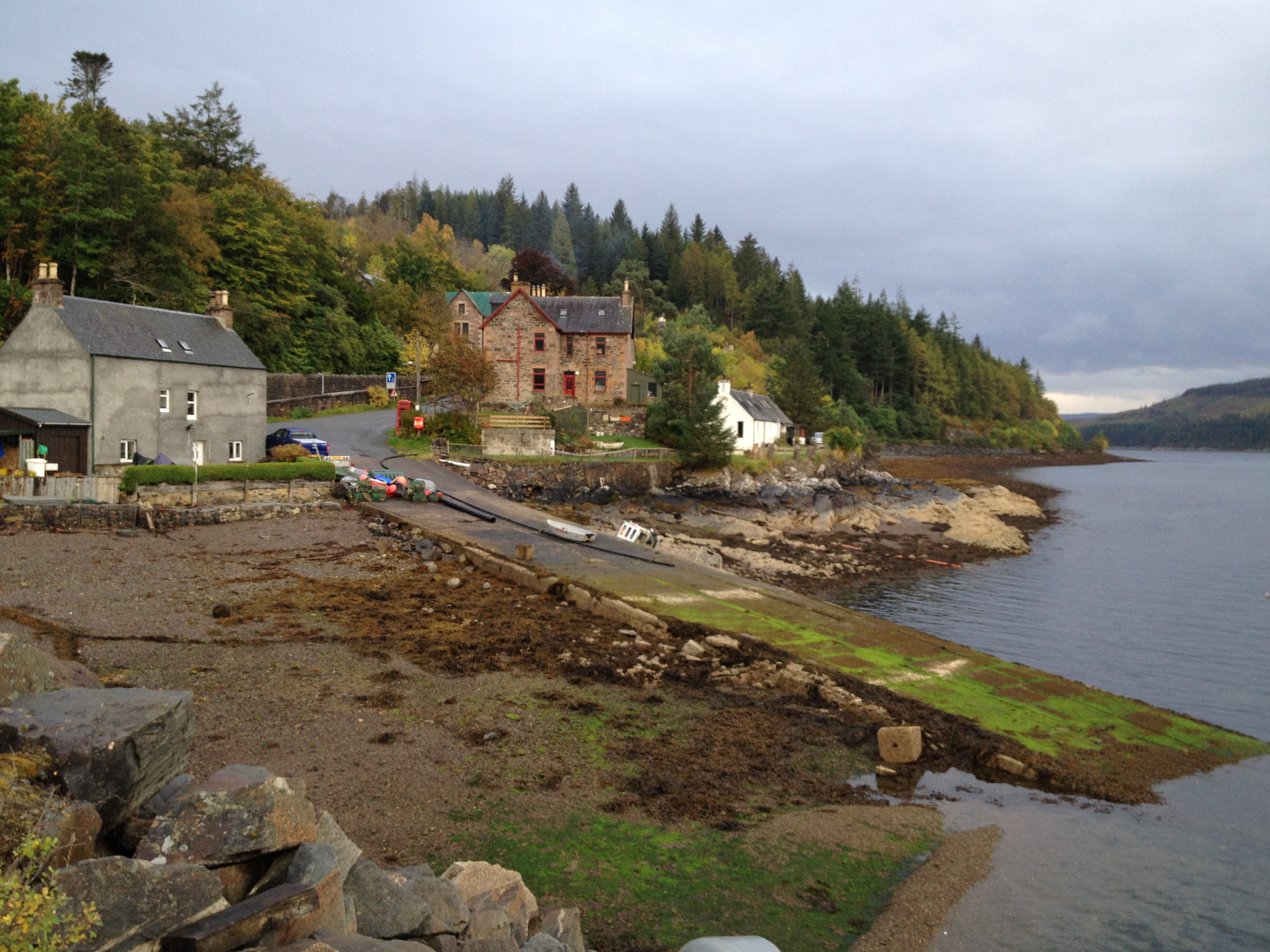
Stromeferry

Stromeferry (Scottish Gaelic: Port an t-Sròim) is a village, located on the south shore of the west coast sea loch, Loch Carron, in western Ross-shire...

Stromeferry railway station

Stromeferry railway station is a station on the Kyle of Lochalsh Line, serving the village of Stromeferry in the Highlands, northern Scotland. Stromeferry...
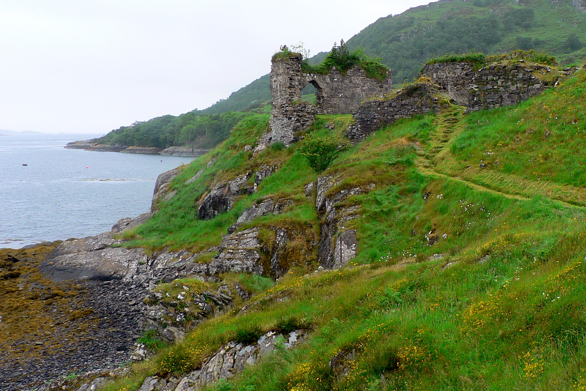
Strome Castle

Strome Castle is a ruined castle on the shore of Loch Carron in Stromemore, 3.5 miles south-west of the village of Lochcarron, on the headland between...

Nearby Amenities

Located within 500m of 57.341741,-5.564825
Source: estimate
Lat/Long: 57.3430879/-5.5638105
Created By: Merkaartor 0.12
Lat/Long: 57.3381204/-5.5660688
Created By: Merkaartor 0.12
Lat/Long: 57.3406657/-5.5720719
Created By: Merkaartor 0.12
Lat/Long: 57.3390847/-5.5646288
Created By: Merkaartor 0.12
Lat/Long: 57.3389588/-5.5646797
Access Cattle: no
Barrier: cattle_grid
Lat/Long: 57.3458222/-5.5613975
Barrier: cattle_grid
Lat/Long: 57.3385299/-5.5645284
Created By: Merkaartor 0.12
Lat/Long: 57.339564/-5.570365
Created By: Merkaartor 0.12
Lat/Long: 57.3384679/-5.565107
Created By: Merkaartor 0.12
Lat/Long: 57.3381204/-5.5666122
Created By: Merkaartor 0.12
Lat/Long: 57.3387679/-5.56921
Created By: Merkaartor 0.12
Lat/Long: 57.3382421/-5.5675002
Created By: Merkaartor 0.12
Lat/Long: 57.3382564/-5.5655121
Post Box
Collection Times: Mo-Fr 13:30; Sa 13:30
Operator: Royal Mail
Operator Wikidata: Q638098
Post Box Mounting: pier
Post Box Type: lamp
Ref: IV40 10
Royal Cypher: scottish_crown
Source: survey
Lat/Long: 57.3419674/-5.5648376
Recycling
Created By: Merkaartor 0.12
Source: survey
Lat/Long: 57.3417736/-5.5646071
Bus Stop
Bench: yes
Shelter: yes
Source: survey
Lat/Long: 57.3420644/-5.5648248
Telephone
Booth: K6
Covered: booth
Phone: +44 1599 577247
Source: survey
Lat/Long: 57.3421125/-5.564812
Created By: Merkaartor 0.12
Lat/Long: 57.3390198/-5.564652
Created By: Merkaartor 0.12
Lat/Long: 57.3417909/-5.5696428
Bus Stop
Public Hall
Naptan AtcoCode: 6700712317
Naptan Bearing: S
Naptan CommonName: Public Hall
Naptan Indicator: o/s
Naptan Landmark: Public Hall
Naptan NaptanCode: 45327647
Naptan Street: Plockton Road
Naptan Verified: no
Source: naptan_import
Lat/Long: 57.3419119/-5.5647396
Source: estimate
Lat/Long: 57.3399801/-5.5646492
Achmore
Name En: Achmore
Name Gd: An t-Achadh Mòr
Place: hamlet
Lat/Long: 57.3421014/-5.5640498
Defibrillator
Defibrillator Location: outside Achmore and Stromeferry Hall
Emergency: defibrillator
Indoor: no
Lat/Long: 57.3418425/-5.5645369
Entrance: main
Lat/Long: 57.3418686/-5.5645342
Power: pole
Lat/Long: 57.3448706/-5.5632958
Power: pole
Lat/Long: 57.3416075/-5.5663745
Power: pole
Lat/Long: 57.3420173/-5.5661568
Power: pole
Lat/Long: 57.3422072/-5.5660577
Power: pole
Lat/Long: 57.3430385/-5.5652088
Power: pole
Lat/Long: 57.343614/-5.5646042
Power: pole
Lat/Long: 57.3440733/-5.5641181
Power: pole
Lat/Long: 57.3458141/-5.5623249
Power: pole
Lat/Long: 57.3421367/-5.5669609
Power: pole
Lat/Long: 57.3418927/-5.5720867
Power: pole
Lat/Long: 57.3413615/-5.570152
Power: pole
Lat/Long: 57.3410731/-5.5705039
Power: pole
Lat/Long: 57.340632/-5.5710323
Power: pole
Lat/Long: 57.3400408/-5.5717433
Power: pole
Lat/Long: 57.3396362/-5.5715692
Power: pole
Lat/Long: 57.3430476/-5.5641689
Power: pole
Lat/Long: 57.3430554/-5.5626332
Power: pole
Lat/Long: 57.3407145/-5.5676991
Power: pole
Lat/Long: 57.3403504/-5.5663122
Power: pole
Lat/Long: 57.3394988/-5.5658732
Power: pole
Lat/Long: 57.3384887/-5.5653726
Power: pole
Lat/Long: 57.3420111/-5.5649485
Power: pole
Lat/Long: 57.3410298/-5.566353
Power: pole
Lat/Long: 57.3379115/-5.5639278
The data included in this document is from www.openstreetmap.org. The data is made available under ODbL.

Have you been to Achmore?

Leave your review of Achmore below (or comments, questions and feedback).