Park Wood Bottom
Settlement in Yorkshire
England
Park Wood Bottom
Park Wood Bottom is a small village located in the county of Yorkshire, England. Situated in the southern part of the county, it lies within the rural district of Craven. The village is nestled in a picturesque valley, surrounded by rolling green hills and dense woodlands, making it a haven for nature lovers and hikers.
With a population of around 200 inhabitants, Park Wood Bottom retains a close-knit community atmosphere. The village is mainly residential, consisting of traditional stone-built houses that add to its charming character. The village also has a small primary school, providing education to the local children.
The natural beauty of Park Wood Bottom is one of its main attractions. The area is known for its abundant wildlife, including various species of birds, mammals, and plants. The village is also home to a small wooded area, which is a popular spot for leisurely walks and picnics. The nearby countryside offers numerous walking and cycling trails, allowing visitors to explore the surrounding landscape.
In terms of amenities, Park Wood Bottom has a local pub that serves as a social hub for residents and visitors alike. However, for more extensive facilities such as supermarkets, shops, and healthcare services, residents typically travel to the nearby towns of Skipton or Keighley.
Overall, Park Wood Bottom offers a peaceful and idyllic setting, perfect for those seeking a tranquil retreat in the heart of the Yorkshire countryside.
If you have any feedback on the listing, please let us know in the comments section below.
Park Wood Bottom Images
Images are sourced within 2km of 53.866302/-1.8954491 or Grid Reference SE0641. Thanks to Geograph Open Source API. All images are credited.


![East Riddlesden Hall and grounds [1] The south front of the hall.
Built on the site of an earlier building, the hall was erected in the 1640s and added to in 1692. Constructed of ashlar under stone slate roofs, the hall has two two-storey porches with wheel (or Yorkshire rose) windows. Many original internal features and fittings remain. Listed, grade I, with details at:
<span class="nowrap"><a title="https://historicengland.org.uk/listing/the-list/list-entry/1283478" rel="nofollow ugc noopener" href="https://historicengland.org.uk/listing/the-list/list-entry/1283478">Link</a><img style="margin-left:2px;" alt="External link" title="External link - shift click to open in new window" src="https://s1.geograph.org.uk/img/external.png" width="10" height="10"/></span>
East Riddlesden Hall is sited on the banks of the River Aire, in Riddlesden, about 1¼ miles northeast of Keighley. Once the centre of a thriving agricultural estate, the grounds of the hall include a tithe barn. Saved from demolition by two local men in 1934, the house and grounds are now in the care of the National Trust.](https://s3.geograph.org.uk/geophotos/07/02/14/7021447_f9e03490.jpg)
![East Riddlesden Hall and grounds [2] The entrance porch in the south front.
Built on the site of an earlier building, the hall was erected in the 1640s and added to in 1692. Constructed of ashlar under stone slate roofs, the hall has two two-storey porches with wheel (or Yorkshire rose) windows. Many original internal features and fittings remain. Listed, grade I, with details at:
<span class="nowrap"><a title="https://historicengland.org.uk/listing/the-list/list-entry/1283478" rel="nofollow ugc noopener" href="https://historicengland.org.uk/listing/the-list/list-entry/1283478">Link</a><img style="margin-left:2px;" alt="External link" title="External link - shift click to open in new window" src="https://s1.geograph.org.uk/img/external.png" width="10" height="10"/></span>
East Riddlesden Hall is sited on the banks of the River Aire, in Riddlesden, about 1¼ miles northeast of Keighley. Once the centre of a thriving agricultural estate, the grounds of the hall include a tithe barn. Saved from demolition by two local men in 1934, the house and grounds are now in the care of the National Trust.](https://s3.geograph.org.uk/geophotos/07/02/14/7021451_f4beef7d.jpg)
![East Riddlesden Hall and grounds [3] The north front of the hall.
Built on the site of an earlier building, the hall was erected in the 1640s and added to in 1692. Constructed of ashlar under stone slate roofs, the hall has two two-storey porches with wheel (or Yorkshire rose) windows. Many original internal features and fittings remain. Listed, grade I, with details at:
<span class="nowrap"><a title="https://historicengland.org.uk/listing/the-list/list-entry/1283478" rel="nofollow ugc noopener" href="https://historicengland.org.uk/listing/the-list/list-entry/1283478">Link</a><img style="margin-left:2px;" alt="External link" title="External link - shift click to open in new window" src="https://s1.geograph.org.uk/img/external.png" width="10" height="10"/></span>
East Riddlesden Hall is sited on the banks of the River Aire, in Riddlesden, about 1¼ miles northeast of Keighley. Once the centre of a thriving agricultural estate, the grounds of the hall include a tithe barn. Saved from demolition by two local men in 1934, the house and grounds are now in the care of the National Trust.](https://s2.geograph.org.uk/geophotos/07/02/14/7021454_c4022af1.jpg)
![East Riddlesden Hall and grounds [4] The south front of the hall.
Built on the site of an earlier building, the hall was erected in the 1640s and added to in 1692. Constructed of ashlar under stone slate roofs, the hall has two two-storey porches with wheel (or Yorkshire rose) windows. Many original internal features and fittings remain. Listed, grade I, with details at:
<span class="nowrap"><a title="https://historicengland.org.uk/listing/the-list/list-entry/1283478" rel="nofollow ugc noopener" href="https://historicengland.org.uk/listing/the-list/list-entry/1283478">Link</a><img style="margin-left:2px;" alt="External link" title="External link - shift click to open in new window" src="https://s1.geograph.org.uk/img/external.png" width="10" height="10"/></span>
East Riddlesden Hall is sited on the banks of the River Aire, in Riddlesden, about 1¼ miles northeast of Keighley. Once the centre of a thriving agricultural estate, the grounds of the hall include a tithe barn. Saved from demolition by two local men in 1934, the house and grounds are now in the care of the National Trust.](https://s3.geograph.org.uk/geophotos/07/02/14/7021455_f86a2c1a.jpg)
![East Riddlesden Hall and grounds [5] One of the rooms of the hall.
Built on the site of an earlier building, the hall was erected in the 1640s and added to in 1692. Constructed of ashlar under stone slate roofs, the hall has two two-storey porches with wheel (or Yorkshire rose) windows. Many original internal features and fittings remain. Listed, grade I, with details at:
<span class="nowrap"><a title="https://historicengland.org.uk/listing/the-list/list-entry/1283478" rel="nofollow ugc noopener" href="https://historicengland.org.uk/listing/the-list/list-entry/1283478">Link</a><img style="margin-left:2px;" alt="External link" title="External link - shift click to open in new window" src="https://s1.geograph.org.uk/img/external.png" width="10" height="10"/></span>
East Riddlesden Hall is sited on the banks of the River Aire, in Riddlesden, about 1¼ miles northeast of Keighley. Once the centre of a thriving agricultural estate, the grounds of the hall include a tithe barn. Saved from demolition by two local men in 1934, the house and grounds are now in the care of the National Trust.](https://s3.geograph.org.uk/geophotos/07/02/14/7021459_7feb94f1.jpg)
![East Riddlesden Hall and grounds [6] One of the rooms of the hall.
Built on the site of an earlier building, the hall was erected in the 1640s and added to in 1692. Constructed of ashlar under stone slate roofs, the hall has two two-storey porches with wheel (or Yorkshire rose) windows. Many original internal features and fittings remain. Listed, grade I, with details at:
<span class="nowrap"><a title="https://historicengland.org.uk/listing/the-list/list-entry/1283478" rel="nofollow ugc noopener" href="https://historicengland.org.uk/listing/the-list/list-entry/1283478">Link</a><img style="margin-left:2px;" alt="External link" title="External link - shift click to open in new window" src="https://s1.geograph.org.uk/img/external.png" width="10" height="10"/></span>
East Riddlesden Hall is sited on the banks of the River Aire, in Riddlesden, about 1¼ miles northeast of Keighley. Once the centre of a thriving agricultural estate, the grounds of the hall include a tithe barn. Saved from demolition by two local men in 1934, the house and grounds are now in the care of the National Trust.](https://s2.geograph.org.uk/geophotos/07/02/14/7021462_a66091ac.jpg)
Park Wood Bottom is located at Grid Ref: SE0641 (Lat: 53.866302, Lng: -1.8954491)
Division: West Riding
Unitary Authority: Bradford
Police Authority: West Yorkshire
What 3 Words
///dated.tender.leads. Near Keighley, West Yorkshire
Nearby Locations
Related Wikis
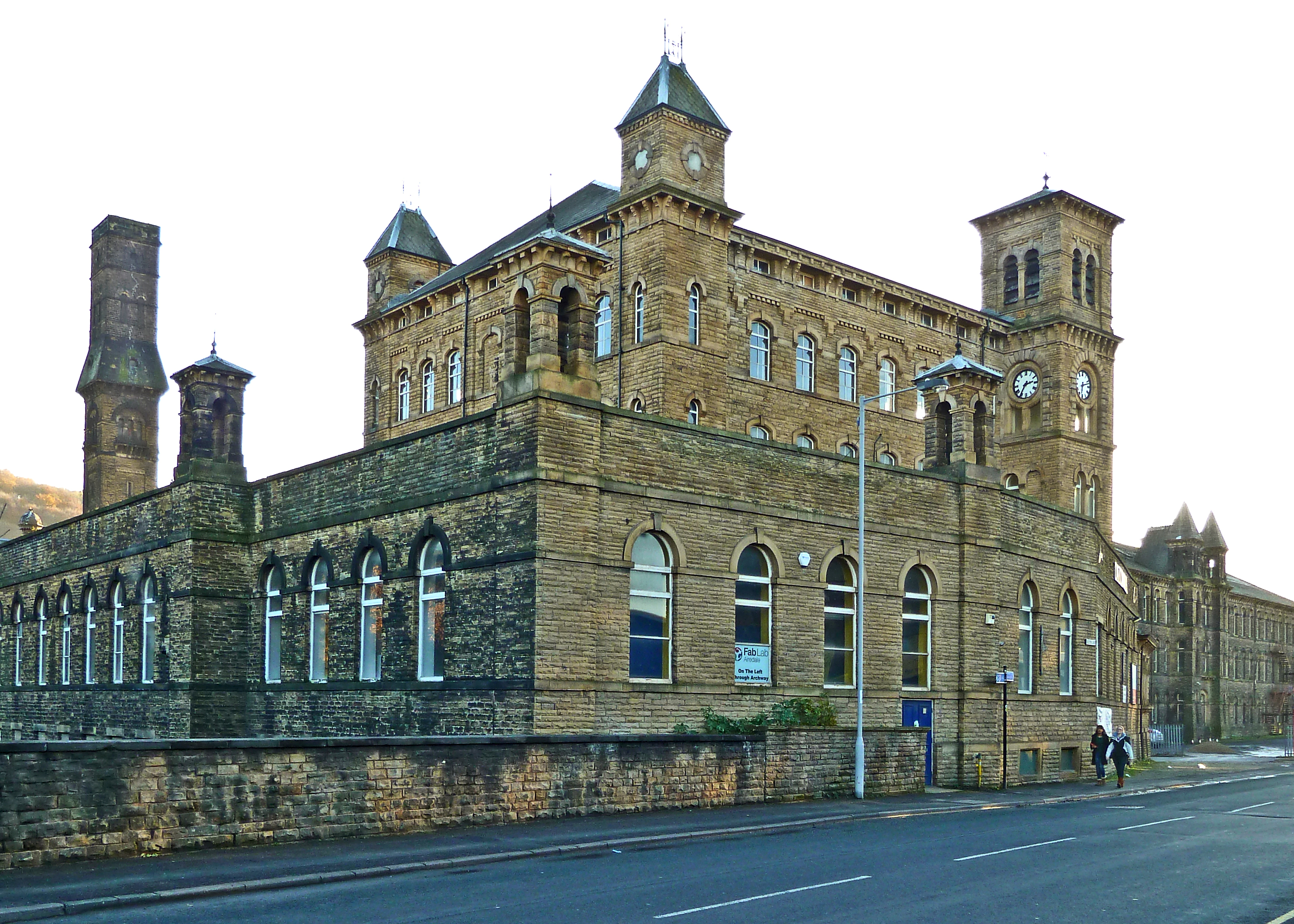
Dalton Mills
Dalton Mills is a 19th century Grade II* Victorian former textile mill located in Keighley, West Yorkshire, England. It was roughly 45,681 sq ft (4,243...

Low Mill
Low Mill is a former textile mill in Keighley, West Yorkshire, England. It was the first industrial building in Keighley, and the first mill in Yorkshire...
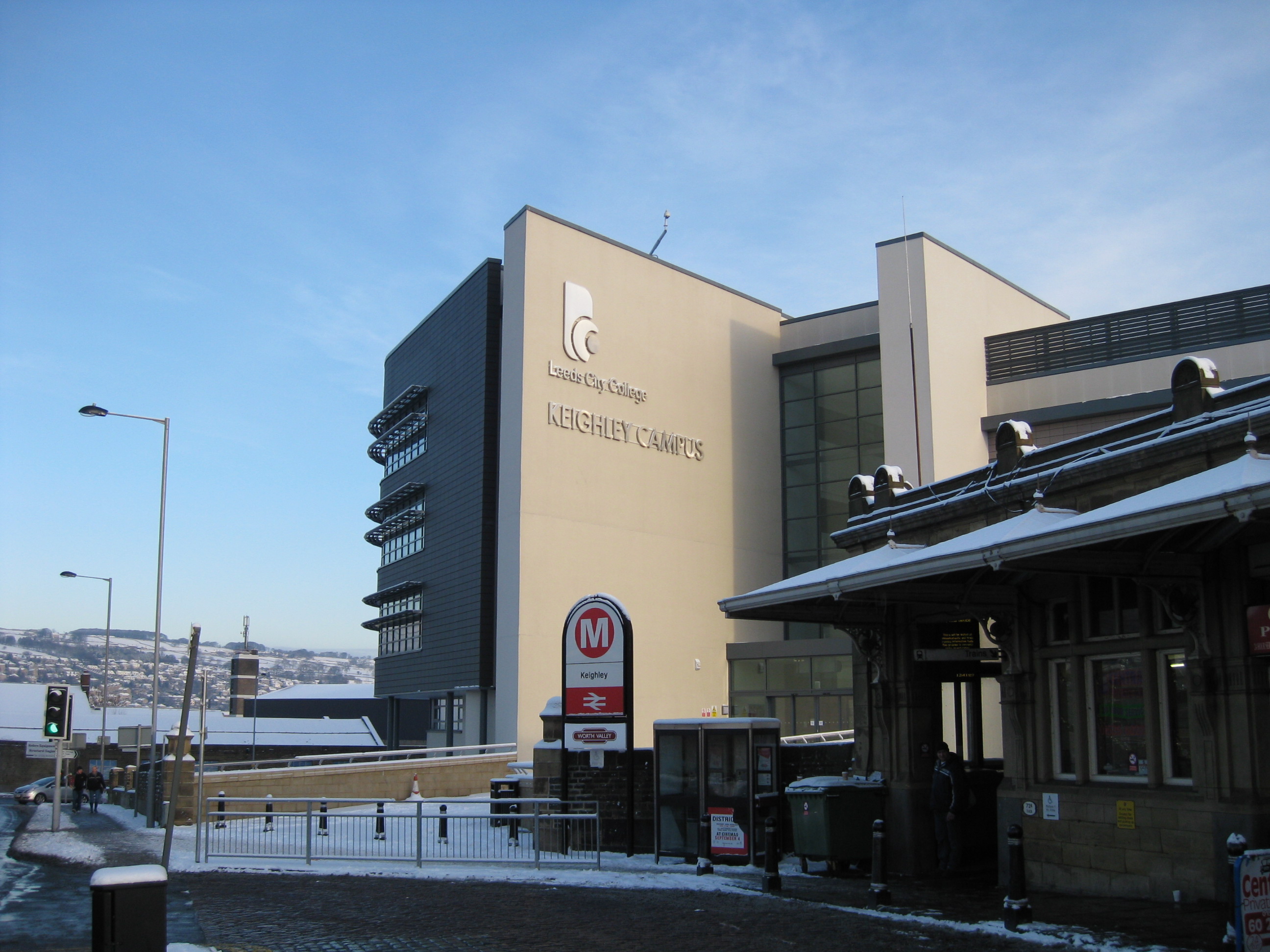
Keighley College
Keighley College is a further education college in Keighley, West Yorkshire, England. It traces its origins to Keighley Mechanics' Institute, founded in...

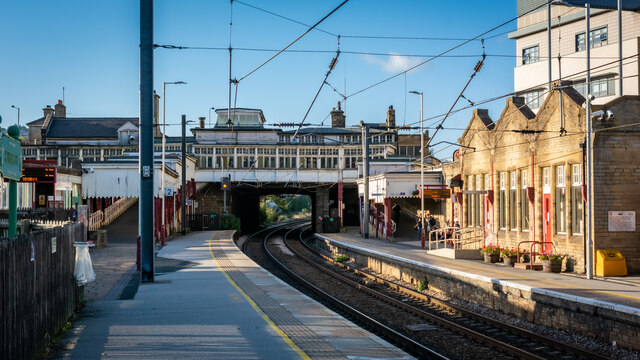
Keighley railway station
Keighley railway station serves the market town of Keighley in West Yorkshire, England. The station is located on the Airedale line, with electric services...
Nearby Amenities
Located within 500m of 53.866302,-1.8954491Have you been to Park Wood Bottom?
Leave your review of Park Wood Bottom below (or comments, questions and feedback).