Merryman's Hill

Settlement in Kent Swale

England

Merryman's Hill

Sheppey - Minster Abbey church Looking at Minster Abbey church from the pathway into its churchyard from the adjacent car park (beside the Working Men's Club).
See shared description below for more information and links.
Sheppey - Minster Abbey church Credit: Rob Farrow

Merryman's Hill is a small village located in the county of Kent, England. Situated approximately 7 miles southeast of the city of Canterbury, it is a picturesque and charming place with a population of around 500 residents. The village is nestled amidst rolling hills and enjoys a tranquil and idyllic setting.

The history of Merryman's Hill dates back centuries, with evidence of human activity in the area from the Roman era. The village itself grew around a medieval manor house, which still stands as a prominent landmark today. The architecture in Merryman's Hill is a mix of historic and modern styles, with traditional cottages and newer residential developments coexisting harmoniously.

Despite its small size, Merryman's Hill offers a range of amenities to its residents. The village has a local pub, The Merryman Arms, which serves as a social hub for the community. There is also a village hall that hosts various events and activities throughout the year. Additionally, Merryman's Hill benefits from its proximity to nearby towns and cities, providing easy access to a wider range of amenities and services.

The surrounding countryside offers ample opportunities for outdoor activities, with numerous walking and cycling routes crisscrossing the area. The village is also in close proximity to several nature reserves and country parks, providing residents with the chance to explore and enjoy the natural beauty of Kent.

Merryman's Hill is a charming and close-knit community that offers a peaceful and picturesque place to live, surrounded by beautiful countryside and steeped in history.

If you have any feedback on the listing, please let us know in the comments section below.

Merryman's Hill Images

Images are sourced within 2km of 51.432516/0.79905472 or Grid Reference TQ9474. Thanks to Geograph Open Source API. All images are credited.

Sheppey - Minster Abbey church Looking at Minster Abbey church from the pathway into its churchyard from the adjacent car park (beside the Working Men's Club).
See shared description below for more information and links.
Sheppey - Minster Abbey church
Looking at Minster Abbey church from the pathway into its churchyard from the adjacent car park (beside the Working Men's Club). See shared description below for more information and links.
Sheppey - Minster Abbey church from the east The eastern end of Minster Abbey church taken from its graveyard. The porch on the left is the way into this interesting old church.
See shared description below for more information and links.
Sheppey - Minster Abbey church from the east
The eastern end of Minster Abbey church taken from its graveyard. The porch on the left is the way into this interesting old church. See shared description below for more information and links.
Sheppey - Minster Abbey church - Green Man carving A rather wonderful carving of the ancient Green Man symbol carved into a stone moulding above a door in St Sexburga's chapel. The Green Man is found from ancient times in both ecclesiastical and secular buildings. See Wikipedia article here: <span class="nowrap"><a title="https://en.wikipedia.org/wiki/Green_Man" rel="nofollow ugc noopener" href="https://en.wikipedia.org/wiki/Green_Man">Link</a><img style="margin-left:2px;" alt="External link" title="External link - shift click to open in new window" src="https://s1.geograph.org.uk/img/external.png" width="10" height="10"/></span>
Sheppey - Minster Abbey church - Green Man carving
A rather wonderful carving of the ancient Green Man symbol carved into a stone moulding above a door in St Sexburga's chapel. The Green Man is found from ancient times in both ecclesiastical and secular buildings. See Wikipedia article here: LinkExternal link
Sheppey - Minster Abbey - Gatehouse The gatehouse to Minster Abbey dates from the C13th and is the only remaining building from the former abbey. It houses a museum, see their own website here: <span class="nowrap"><a title="https://www.minstergatehouse.co.uk" rel="nofollow ugc noopener" href="https://www.minstergatehouse.co.uk">Link</a><img style="margin-left:2px;" alt="External link" title="External link - shift click to open in new window" src="https://s1.geograph.org.uk/img/external.png" width="10" height="10"/></span>
If you wish to visit, I suggest you check its opening hours.
Sheppey - Minster Abbey - Gatehouse
The gatehouse to Minster Abbey dates from the C13th and is the only remaining building from the former abbey. It houses a museum, see their own website here: LinkExternal link If you wish to visit, I suggest you check its opening hours.
Sheppey - Minster Abbey - Gatehouse and museum Looking at the portal of <a href="https://www.geograph.org.uk/photo/7395745">TQ9572 : Sheppey - Minster Abbey - Gatehouse</a> which, apart from the church, is all that remains of the former abbey on this site, though since 1937 there has been an active nunnery here. This gatehouse houses a small museum, currently [Feb 2023] only open for a couple of hours on a Saturday. See their website here: <span class="nowrap"><a title="https://www.minstergatehouse.co.uk/opening-times" rel="nofollow ugc noopener" href="https://www.minstergatehouse.co.uk/opening-times">Link</a><img style="margin-left:2px;" alt="External link" title="External link - shift click to open in new window" src="https://s1.geograph.org.uk/img/external.png" width="10" height="10"/></span>
Sheppey - Minster Abbey - Gatehouse and museum
Looking at the portal of TQ9572 : Sheppey - Minster Abbey - Gatehouse which, apart from the church, is all that remains of the former abbey on this site, though since 1937 there has been an active nunnery here. This gatehouse houses a small museum, currently [Feb 2023] only open for a couple of hours on a Saturday. See their website here: LinkExternal link
Sheppey - Minster Abbey church - Eastern aspect A view of the eastern end of the Abbey Church of St Mary and St Sexburga in Minster, Sheppey. Taken from its churchyard.
Sheppey - Minster Abbey church - Eastern aspect
A view of the eastern end of the Abbey Church of St Mary and St Sexburga in Minster, Sheppey. Taken from its churchyard.
Sheppey - Minster Abbey church - Eastern end of main church The Abbey Church of St Mary and St Sexburga in Minster, Sheppey was originally effectively two churches joined together. To the south lies the larger section (seen here) which was for the lay people of the town while the smaller (but still quite large) northern section was for use by the denizens of the abbey.
This is a view of the eastern end of the main section, with the altar and three-lancet Early English East Window with C20th glass. According to westsheppeyparish.org.uk this glass was originally installed in St Michael’s, Cornhill, London. When that church was to be demolished in 1964, the vicar of Minster, Rev R.D. Wain, who had connections to the London parish arranged for the glass to be transferred to this church. This website goes on to say that "The centre panel shows the stoning of St Stephen, and the right hand panel the people of the world being brought to Christ." - however, I have difficulty aligning this description with the windows seen here - so there may be some confusion!
Sheppey - Minster Abbey church - Eastern end of main church
The Abbey Church of St Mary and St Sexburga in Minster, Sheppey was originally effectively two churches joined together. To the south lies the larger section (seen here) which was for the lay people of the town while the smaller (but still quite large) northern section was for use by the denizens of the abbey. This is a view of the eastern end of the main section, with the altar and three-lancet Early English East Window with C20th glass. According to westsheppeyparish.org.uk this glass was originally installed in St Michael’s, Cornhill, London. When that church was to be demolished in 1964, the vicar of Minster, Rev R.D. Wain, who had connections to the London parish arranged for the glass to be transferred to this church. This website goes on to say that "The centre panel shows the stoning of St Stephen, and the right hand panel the people of the world being brought to Christ." - however, I have difficulty aligning this description with the windows seen here - so there may be some confusion!
Sheppey - Minster Abbey church - Western window This fine C20th glass is in the West Window of the main part of the Abbey Church of St Mary and St Sexburga in Minster, Sheppey.
Sheppey - Minster Abbey church - Western window
This fine C20th glass is in the West Window of the main part of the Abbey Church of St Mary and St Sexburga in Minster, Sheppey.
Sheppey - Minster Abbey church - Pelican round window This circular window featuring a 'Pelican in her piety' is situated above the central lancet of <a href="https://www.geograph.org.uk/photo/7401653">TQ9572 : Sheppey - Minster Abbey church - Western window</a>.
A 'Pelican in her piety' is an ancient heraldic device depicting a pelican 'vulning herself' - that is to say, pecking at her breast to draw blood to feed to her offspring. By analogy to Christ having his blood spilt to save mankind this entirely fictional behaviour of the pelican was adopted as a Christian symbol.
For an extensive discussion of this motif, see <span class="nowrap"><a title="https://www.theschooloftheology.org/posts/essay/symbols-the-pelican-in-her-piety" rel="nofollow ugc noopener" href="https://www.theschooloftheology.org/posts/essay/symbols-the-pelican-in-her-piety">Link</a><img style="margin-left:2px;" alt="External link" title="External link - shift click to open in new window" src="https://s1.geograph.org.uk/img/external.png" width="10" height="10"/></span>
Sheppey - Minster Abbey church - Pelican round window
This circular window featuring a 'Pelican in her piety' is situated above the central lancet of TQ9572 : Sheppey - Minster Abbey church - Western window. A 'Pelican in her piety' is an ancient heraldic device depicting a pelican 'vulning herself' - that is to say, pecking at her breast to draw blood to feed to her offspring. By analogy to Christ having his blood spilt to save mankind this entirely fictional behaviour of the pelican was adopted as a Christian symbol. For an extensive discussion of this motif, see LinkExternal link
Sheppey - Minster Abbey church - Tomb of Robert de Shurland Baron Robert de Shurland (c. 1250-1327) was knighted by Edward I after the Battle of Caerlaverock in Scotland, and created Lord of Shurland & Minster and Baron Sheppey c.1300.

A story about him is told in the collection known as the Ingoldsby Legends. In brief, having been warned by an old crone or witch that his faithful horse, Grey Dolphin, would kill him he promptly decapitated the poor animal. Some while later, wandering along a beach he came across the bones of his former trusty steed, and recounting the story to his comrades, he kicked the old nag's bones. A splinter punctured his shoe and he got a blood infection from which he died, fulfilling the prophecy. Originally there was a carving of the head of the horse behind his legs but sadly it is no longer there.
For the full, and very lengthy legend, see <span class="nowrap"><a title="https://www.exclassics.com/ingold/ing8.htm" rel="nofollow ugc noopener" href="https://www.exclassics.com/ingold/ing8.htm">Link</a><img style="margin-left:2px;" alt="External link" title="External link - shift click to open in new window" src="https://s1.geograph.org.uk/img/external.png" width="10" height="10"/></span>

For a closer view of the baron's head, see <a href="https://www.geograph.org.uk/photo/7401685">TQ9572 : Sheppey - Minster Abbey church - Robert de Shurland - head</a>
Sheppey - Minster Abbey church - Tomb of Robert de Shurland
Baron Robert de Shurland (c. 1250-1327) was knighted by Edward I after the Battle of Caerlaverock in Scotland, and created Lord of Shurland & Minster and Baron Sheppey c.1300. A story about him is told in the collection known as the Ingoldsby Legends. In brief, having been warned by an old crone or witch that his faithful horse, Grey Dolphin, would kill him he promptly decapitated the poor animal. Some while later, wandering along a beach he came across the bones of his former trusty steed, and recounting the story to his comrades, he kicked the old nag's bones. A splinter punctured his shoe and he got a blood infection from which he died, fulfilling the prophecy. Originally there was a carving of the head of the horse behind his legs but sadly it is no longer there. For the full, and very lengthy legend, see LinkExternal link For a closer view of the baron's head, see TQ9572 : Sheppey - Minster Abbey church - Robert de Shurland - head
Sheppey - Minster Abbey church - Robert de Shurland - head A close view of the head of <a href="https://www.geograph.org.uk/photo/7401680">TQ9572 : Sheppey - Minster Abbey church - Tomb of Robert de Shurland</a> - see that image for more details.
Sheppey - Minster Abbey church - Robert de Shurland - head
A close view of the head of TQ9572 : Sheppey - Minster Abbey church - Tomb of Robert de Shurland - see that image for more details.
Sheppey - Minster Abbey church - Tomb of Sir Thomas Cheyne Sir Thomas Cheyne (c.1485 – 16 December 1558) was Household Chancellor to Henry VIII and Lord  Warden of Cinque Ports from 1536 until his death. He was also appointed Sheriff of Kent in 1515. At the dissolution of the monasteries he was granted (or bought from the Crown) the abbey and all the lands around it along with Davington Priory.
Sheppey - Minster Abbey church - Tomb of Sir Thomas Cheyne
Sir Thomas Cheyne (c.1485 – 16 December 1558) was Household Chancellor to Henry VIII and Lord Warden of Cinque Ports from 1536 until his death. He was also appointed Sheriff of Kent in 1515. At the dissolution of the monasteries he was granted (or bought from the Crown) the abbey and all the lands around it along with Davington Priory.
Sheppey - Minster Abbey church - Sir John de Northwode brass A memorial brass to Sir John de Northwode (24th Apr 1254 - 26th May 1319) who was  Sheriff of Kent from 1292 to 1306. A brass to his wife <a href="https://www.geograph.org.uk/photo/7401717">TQ9572 : Sheppey - Minster Abbey church - Joan (née) Badlesmere brass</a> can be seen nearby.
For more information on Sir John, see <span class="nowrap"><a title="https://www.findagrave.com/memorial/75632464/john-de-northwode" rel="nofollow ugc noopener" href="https://www.findagrave.com/memorial/75632464/john-de-northwode">Link</a><img style="margin-left:2px;" alt="External link" title="External link - shift click to open in new window" src="https://s1.geograph.org.uk/img/external.png" width="10" height="10"/></span>
For much more information about both brasses, see <span class="nowrap"><a title="https://kentarchaeology.org.uk/arch-cant/vol/9/brass-sir-john-de-northwode-and-lady-minster-church-sheppey" rel="nofollow ugc noopener" href="https://kentarchaeology.org.uk/arch-cant/vol/9/brass-sir-john-de-northwode-and-lady-minster-church-sheppey">Link</a><img style="margin-left:2px;" alt="External link" title="External link - shift click to open in new window" src="https://s1.geograph.org.uk/img/external.png" width="10" height="10"/></span>
Sheppey - Minster Abbey church - Sir John de Northwode brass
A memorial brass to Sir John de Northwode (24th Apr 1254 - 26th May 1319) who was Sheriff of Kent from 1292 to 1306. A brass to his wife TQ9572 : Sheppey - Minster Abbey church - Joan (née) Badlesmere brass can be seen nearby. For more information on Sir John, see LinkExternal link For much more information about both brasses, see LinkExternal link
Sheppey - Minster Abbey church - Joan (née) Badlesmere brass Joan Badlesmere (c.1255 - 2nd June 1319) was the wife of Sir John de Northwode whose memorial brass is nearby <a href="https://www.geograph.org.uk/photo/7401709">TQ9572 : Sheppey - Minster Abbey church - Sir John de Northwode brass</a>.
For more information on Joan see <span class="nowrap"><a title="https://www.geni.com/people/Joan-de-Northwood/6000000008777796597" rel="nofollow ugc noopener" href="https://www.geni.com/people/Joan-de-Northwood/6000000008777796597">Link</a><img style="margin-left:2px;" alt="External link" title="External link - shift click to open in new window" src="https://s1.geograph.org.uk/img/external.png" width="10" height="10"/></span>
For much more information about both brasses, see <span class="nowrap"><a title="https://kentarchaeology.org.uk/arch-cant/vol/9/brass-sir-john-de-northwode-and-lady-minster-church-sheppey" rel="nofollow ugc noopener" href="https://kentarchaeology.org.uk/arch-cant/vol/9/brass-sir-john-de-northwode-and-lady-minster-church-sheppey">Link</a><img style="margin-left:2px;" alt="External link" title="External link - shift click to open in new window" src="https://s1.geograph.org.uk/img/external.png" width="10" height="10"/></span>
Sheppey - Minster Abbey church - Joan (née) Badlesmere brass
Joan Badlesmere (c.1255 - 2nd June 1319) was the wife of Sir John de Northwode whose memorial brass is nearby TQ9572 : Sheppey - Minster Abbey church - Sir John de Northwode brass. For more information on Joan see LinkExternal link For much more information about both brasses, see LinkExternal link
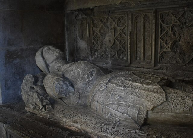
Sheppey - Minster Abbey church - Tomb of unknown Yorkist There is considerable speculation as to who is depicted in this effigy, with suggestions including George Duke of Clarence (murdered on the orders of his brother Edward IV by drowning in a vat of Malmsey wine on 18th February 1478) - however it is almost universally accepted that George is buried with his wife in Tewkesbury Abbey.
Another candidate is Sir Hugh de Badlesemere a Yorkist soldier. However as the accompanying heraldry has been defaced - probably by anti-Yorkist Tudors in the C16th - we will probably never know for sure.
The tomb is to be found within a niche in the north wall of the abbey church at Minster, Sheppey.
Sheppey - Minster Abbey church - Tomb of unknown Yorkist
There is considerable speculation as to who is depicted in this effigy, with suggestions including George Duke of Clarence (murdered on the orders of his brother Edward IV by drowning in a vat of Malmsey wine on 18th February 1478) - however it is almost universally accepted that George is buried with his wife in Tewkesbury Abbey. Another candidate is Sir Hugh de Badlesemere a Yorkist soldier. However as the accompanying heraldry has been defaced - probably by anti-Yorkist Tudors in the C16th - we will probably never know for sure. The tomb is to be found within a niche in the north wall of the abbey church at Minster, Sheppey.
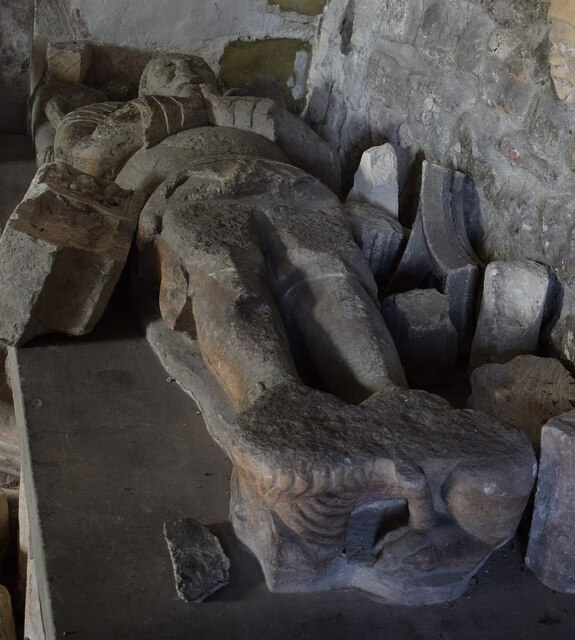
Sheppey - Minster Abbey church - Mediæval nobleman's effigy This C15th effigy of a knight was dug up in the churchyard in 1833. His identity is unknown for sure but one suggestion is the captured Spaniard General Geronimo. He had been held captive for ransom since 1588 at nearby Queenborough Castle. Unfortunately for him the ransom was never paid and he died in captivity in 1591 with the church's records showing that he was buried here in that year.
Whoever he is, his effigy now lies against the north wall of the abbey church at Minster on the Isle of Sheppey.
Sheppey - Minster Abbey church - Mediæval nobleman's effigy
This C15th effigy of a knight was dug up in the churchyard in 1833. His identity is unknown for sure but one suggestion is the captured Spaniard General Geronimo. He had been held captive for ransom since 1588 at nearby Queenborough Castle. Unfortunately for him the ransom was never paid and he died in captivity in 1591 with the church's records showing that he was buried here in that year. Whoever he is, his effigy now lies against the north wall of the abbey church at Minster on the Isle of Sheppey.
Sheppey - View along coastal path near Cheyney Rock The coastal path (actually a Restricted Byway) on the western section of the northern coast of the Isle of Sheppey runs from Blue Town in Sheerness to Barton's Point to the north of Minster sandwiched between Marine Parade and the sea. It is seen here near Cheyney Rock looking westwards towards the Marine Town area of Sheerness.
Sheppey - View along coastal path near Cheyney Rock
The coastal path (actually a Restricted Byway) on the western section of the northern coast of the Isle of Sheppey runs from Blue Town in Sheerness to Barton's Point to the north of Minster sandwiched between Marine Parade and the sea. It is seen here near Cheyney Rock looking westwards towards the Marine Town area of Sheerness.
Sheppey - Shellfish collection rules This interesting sign details the rules governing seafood collection in the area. The collection of cockles is entirely banned, while Manila Clams can be harvested provided they have a width of at least 35mm. Pacific Oyster, meanwhile, have no restrictions on them at all.
Sheppey - Shellfish collection rules
This interesting sign details the rules governing seafood collection in the area. The collection of cockles is entirely banned, while Manila Clams can be harvested provided they have a width of at least 35mm. Pacific Oyster, meanwhile, have no restrictions on them at all.
Show me another place!

Merryman's Hill is located at Grid Ref: TQ9474 (Lat: 51.432516, Lng: 0.79905472)

Administrative County: Kent

District: Swale

Police Authority: Kent

What 3 Words

///mailbox.poppy.shredder. Near Sheerness, Kent

Related Wikis

Barton's Point Coastal Park

Barton's Point Coastal Park is on the Isle of Sheppey, in Kent, England. It lies between Minster and Sheerness. Within the park is a former military ditch/canal...

East Minster railway station

East Minster is a disused railway station serving Minster on the Isle of Sheppey. It opened in 1902 and closed in 1950. == References == == External... ==

Minster, Swale

Minster is a town on the north coast of the Isle of Sheppey in Kent, south-east England. It is in the Swale administrative district, and within that, in...

Oasis Academy Isle of Sheppey

Oasis Academy Isle of Sheppey is a coeducational secondary school and sixth form with academy status, located over two sites in Minster-on-Sea on the Isle...

Nearby Amenities

Located within 500m of 51.432516,0.79905472
Traffic Calming: hump
Lat/Long: 51.433293/0.8024953
Traffic Calming: hump
Lat/Long: 51.4325613/0.8040532
Post Box
Operator: Royal Mail
Operator Wikidata: Q638098
Post Box Type: lamp
Postal Code: ME12
Ref: ME12 13
Lat/Long: 51.4345337/0.7994077
Toilets
Access: yes
Toilets Disposal: flush
Lat/Long: 51.4347495/0.7993499
The Abbey Hotel
Tourism: hotel
Lat/Long: 51.4321197/0.7981914
Bus Stop
The Beach
Bus: yes
Flag: no
Naptan AtcoCode: 2400101817
Naptan Bearing: W
Naptan BusStopType: CUS
Naptan CommonName: The Beach
Naptan Indicator: opp
Naptan NaptanCode: kntjgmdt
Naptan Street: The Leas
Naptan Verified: no
Public Transport: platform
Source: naptan_import
Lat/Long: 51.4347758/0.7998271
Bus Stop
The Beach
Alt Name: The White House
Bus: yes
Flag: no
Naptan AltCommonName: The White House
Naptan AltIndicator: Opp
Naptan AltLandmark: Minster Beach
Naptan AltStreet: The Leas
Naptan AtcoCode: 240097651
Naptan Bearing: E
Naptan BusStopType: CUS
Naptan CommonName: The Beach
Naptan Indicator: adj
Naptan Landmark: The White House
Naptan NaptanCode: kntgpmam
Naptan Street: The Leas
Naptan Verified: no
Public Transport: platform
Source: naptan_import
Lat/Long: 51.434962/0.7999393
Bus Stop
The White House
Bus: yes
Naptan AtcoCode: 2400A012850A
Naptan Bearing: S
Naptan CommonName: The White House
Naptan Indicator: Opp
Naptan Landmark: The Leas
Naptan NaptanCode: kntapadw
Naptan Street: The Broadway
Naptan Verified: no
Public Transport: platform
Source: naptan_import
Lat/Long: 51.4345858/0.7994989
Bus Stop
The Abbey Hotel
Bus: yes
Naptan AtcoCode: 2400A012860A
Naptan Bearing: S
Naptan CommonName: The Abbey Hotel
Naptan Indicator: Opp
Naptan Landmark: Augustine Road
Naptan NaptanCode: kntapaga
Naptan Street: The Broadway
Naptan Verified: no
Public Transport: platform
Source: naptan_import
Lat/Long: 51.4325685/0.7992317
Bus Stop
Wards Hill Road Bottom
Bus: yes
Naptan AtcoCode: 2400A012870A
Naptan Bearing: N
Naptan CommonName: Wards Hill Road Bottom
Naptan Indicator: opp
Naptan Landmark: Scrapsgate Coast End
Naptan NaptanCode: kntapagd
Naptan Street: The Broadway
Naptan Verified: no
Public Transport: platform
Source: naptan_import
Lat/Long: 51.4301921/0.7978058
Bus Stop
The Abbey Hotel
Bus: yes
Naptan AtcoCode: 2400A012880A
Naptan Bearing: N
Naptan CommonName: The Abbey Hotel
Naptan Indicator: Adj
Naptan Landmark: Augustine Road
Naptan NaptanCode: kntapagj
Naptan Street: The Broadway
Naptan Verified: no
Public Transport: platform
Source: naptan_import
Lat/Long: 51.4317956/0.7982547
Bus Stop
The White House
Bus: yes
Naptan AtcoCode: 2400A012890A
Naptan Bearing: N
Naptan CommonName: The White House
Naptan Indicator: Adj
Naptan Landmark: The Leas
Naptan NaptanCode: kntapagm
Naptan Street: The Broadway
Naptan Verified: no
Public Transport: platform
Source: naptan_import
Lat/Long: 51.4342638/0.7994217
Bus Stop
Wards Hill Road Bottom
Bus: yes
Naptan AtcoCode: 2400A015510A
Naptan Bearing: S
Naptan CommonName: Wards Hill Road Bottom
Naptan Indicator: adj
Naptan Landmark: Wards Hill
Naptan NaptanCode: kntaptga
Naptan Street: The Broadway
Naptan Verified: no
Public Transport: platform
Source: naptan_import
Lat/Long: 51.429199/0.7979609
Bus Stop
Wards Hill Road Bottom
Bus: yes
Naptan AtcoCode: 2400A015800A
Naptan Bearing: SE
Naptan CommonName: Wards Hill Road Bottom
Naptan Indicator: SE-bound
Naptan Landmark: The Broadway
Naptan NaptanCode: kntaptwd
Naptan Street: Wards Hill Rd
Naptan Verified: no
Public Transport: platform
Source: naptan_import
Lat/Long: 51.4294675/0.7983945
Restaurant
The Playa Free House
Addr Street: The Leas
Phone: +44 1795 873059
Website: http://www.the-playa.com/
Lat/Long: 51.4337688/0.8013519
Traffic Calming: hump
Lat/Long: 51.4319592/0.8054137
Traffic Calming: hump
Lat/Long: 51.4329625/0.8032089
Traffic Calming: hump
Lat/Long: 51.4338964/0.8014092
Generator Method: photovoltaic
Generator Output Electricity: yes
Generator Source: solar
Generator Type: solar_photovoltaic_panel
Location: roof
Power: generator
Lat/Long: 51.4325662/0.799596
Generator Method: photovoltaic
Generator Output Electricity: yes
Generator Source: solar
Generator Type: solar_photovoltaic_panel
Location: roof
Power: generator
Lat/Long: 51.4322936/0.8016318
Generator Method: photovoltaic
Generator Output Electricity: yes
Generator Source: solar
Generator Type: solar_photovoltaic_panel
Location: roof
Power: generator
Lat/Long: 51.4341614/0.8007145
Generator Method: photovoltaic
Generator Output Electricity: yes
Generator Source: solar
Generator Type: solar_photovoltaic_panel
Location: roof
Power: generator
Lat/Long: 51.4315127/0.8058134
Generator Method: photovoltaic
Generator Output Electricity: yes
Generator Source: solar
Generator Type: solar_photovoltaic_panel
Location: roof
Power: generator
Lat/Long: 51.4316866/0.8053708
Generator Method: photovoltaic
Generator Output Electricity: yes
Generator Source: solar
Generator Type: solar_photovoltaic_panel
Location: roof
Power: generator
Lat/Long: 51.4320344/0.804483
Generator Method: photovoltaic
Generator Output Electricity: yes
Generator Source: solar
Generator Type: solar_photovoltaic_panel
Location: roof
Power: generator
Lat/Long: 51.4323689/0.8030131
Generator Method: photovoltaic
Generator Output Electricity: yes
Generator Source: solar
Generator Type: solar_photovoltaic_panel
Location: roof
Power: generator
Lat/Long: 51.4330377/0.8025062
Generator Method: photovoltaic
Generator Output Electricity: yes
Generator Source: solar
Generator Type: solar_photovoltaic_panel
Location: roof
Power: generator
Lat/Long: 51.4311582/0.8047619
Generator Method: photovoltaic
Generator Output Electricity: yes
Generator Source: solar
Generator Type: solar_photovoltaic_panel
Location: roof
Power: generator
Lat/Long: 51.4310244/0.8048665
Generator Method: photovoltaic
Generator Output Electricity: yes
Generator Source: solar
Generator Type: solar_photovoltaic_panel
Location: roof
Power: generator
Lat/Long: 51.4310261/0.805116
Generator Method: photovoltaic
Generator Output Electricity: yes
Generator Source: solar
Generator Type: solar_photovoltaic_panel
Location: roof
Power: generator
Lat/Long: 51.4294023/0.8015138
Generator Method: photovoltaic
Generator Output Electricity: yes
Generator Source: solar
Generator Type: solar_photovoltaic_panel
Location: roof
Power: generator
Lat/Long: 51.4294107/0.8014226
Generator Method: photovoltaic
Generator Output Electricity: yes
Generator Source: solar
Generator Type: solar_photovoltaic_panel
Location: roof
Power: generator
Lat/Long: 51.4298722/0.7981878
Generator Method: photovoltaic
Generator Output Electricity: yes
Generator Source: solar
Generator Type: solar_photovoltaic_panel
Location: roof
Power: generator
Lat/Long: 51.4304558/0.7981449
Generator Method: photovoltaic
Generator Output Electricity: yes
Generator Source: solar
Generator Type: solar_photovoltaic_panel
Location: roof
Power: generator
Lat/Long: 51.4304542/0.7981986
Generator Method: photovoltaic
Generator Output Electricity: yes
Generator Source: solar
Generator Type: solar_photovoltaic_panel
Location: roof
Power: generator
Lat/Long: 51.4303789/0.800803
Generator Method: photovoltaic
Generator Output Electricity: yes
Generator Source: solar
Generator Type: solar_photovoltaic_panel
Location: roof
Power: generator
Lat/Long: 51.4303639/0.8008406
Generator Method: photovoltaic
Generator Output Electricity: yes
Generator Source: solar
Generator Type: solar_photovoltaic_panel
Location: roof
Power: generator
Lat/Long: 51.4313438/0.8010471
Generator Method: photovoltaic
Generator Output Electricity: yes
Generator Source: solar
Generator Type: solar_photovoltaic_panel
Location: roof
Power: generator
Lat/Long: 51.4299976/0.8038393
Generator Method: photovoltaic
Generator Output Electricity: yes
Generator Source: solar
Generator Type: solar_photovoltaic_panel
Location: roof
Power: generator
Lat/Long: 51.4318471/0.8031955
Generator Method: photovoltaic
Generator Output Electricity: yes
Generator Source: solar
Generator Type: solar_photovoltaic_panel
Location: roof
Power: generator
Lat/Long: 51.4331815/0.7956558
Generator Method: photovoltaic
Generator Output Electricity: yes
Generator Source: solar
Generator Type: solar_photovoltaic_panel
Location: roof
Power: generator
Lat/Long: 51.4337584/0.7951972
Generator Method: photovoltaic
Generator Output Electricity: yes
Generator Source: solar
Generator Type: solar_photovoltaic_panel
Location: roof
Power: generator
Lat/Long: 51.4332518/0.7963318
Generator Method: photovoltaic
Generator Output Electricity: yes
Generator Source: solar
Generator Type: solar_photovoltaic_panel
Location: roof
Power: generator
Lat/Long: 51.4290645/0.7981718
Generator Method: photovoltaic
Generator Output Electricity: yes
Generator Source: solar
Generator Type: solar_photovoltaic_panel
Location: roof
Power: generator
Lat/Long: 51.4284608/0.7982361
Ford: yes
Lat/Long: 51.4358764/0.794366
Barrier: height_restrictor
Maxheight: 2
Lat/Long: 51.4291038/0.7970788
Give Way
Direction: backward
Lat/Long: 51.4296364/0.7976239
Give Way
Direction: forward
Lat/Long: 51.4296119/0.7978051
Give Way
Direction: forward
Lat/Long: 51.4297904/0.7977948
Merryman's Hill
Place: suburb
Source: OS Open Names
Lat/Long: 51.4325198/0.799084
Rotary Club of Minster on Sea
Addr Street: The Abbey Hotel and Conference Centre, The Broadway, Minster on Sea, Sheerness, Kent, ME12 2DA
Description: The Rotary Club of Minster on Sea is club of lively individuals whose purpose is fundraising and community support.
Lat/Long: 51.4325221/0.7982359
Barrier: height_restrictor
Maxheight: 2.2
Lat/Long: 51.436234/0.7962022
Barrier: height_restrictor
Maxheight: 2.2
Lat/Long: 51.435754/0.7973583
The data included in this document is from www.openstreetmap.org. The data is made available under ODbL.

Have you been to Merryman's Hill?

Leave your review of Merryman's Hill below (or comments, questions and feedback).