Langleigh

Settlement in Devon North Devon

England

Langleigh

The South West Coast Path
The South West Coast Path Credit: Tim Glover

Langleigh is a small village located in the county of Devon, in southwest England. It is situated on the North Devon coast, overlooking the Bristol Channel. Langleigh is part of the civil parish of Ilfracombe, and it lies approximately 4 miles north of the town center.

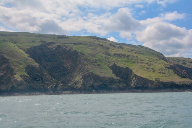
The village of Langleigh is known for its picturesque and idyllic setting, surrounded by lush green fields and rolling hills. It offers stunning views of the coastline, with its rugged cliffs and sandy beaches. The area is popular among tourists and visitors who are drawn to its natural beauty and tranquility.

Despite its small size, Langleigh has a rich history dating back many centuries. It is believed to have been settled since the Roman era, and evidence of ancient settlements and structures can still be found in the area. Today, the village retains its traditional charm, with a handful of historic buildings and cottages that add to its character.

Langleigh is a peaceful and close-knit community, with a small population of residents. The village does not have many amenities or facilities, but it benefits from its proximity to nearby towns such as Ilfracombe, which offer a wider range of services.

Overall, Langleigh is a hidden gem in the Devon countryside, offering a peaceful retreat for those seeking a break from the hustle and bustle of city life. Its natural beauty, historical significance, and serene atmosphere make it a desirable destination for tourists and locals alike.

If you have any feedback on the listing, please let us know in the comments section below.

Langleigh Images

Images are sourced within 2km of 51.201144/-4.1321529 or Grid Reference SS5146. Thanks to Geograph Open Source API. All images are credited.

The South West Coast Path
Footpath and track to Whitestone Farm
Lincombe House
Lincombe House
High Banks, Lincombe
North Devon : Coastal Scenery Looking towards Flat Point on the North Devon coastline.
North Devon : Coastal Scenery
Looking towards Flat Point on the North Devon coastline.
North Devon : Coastal Scenery Looking across the North Devon coastline and towards Flat Point.
North Devon : Coastal Scenery
Looking across the North Devon coastline and towards Flat Point.
North Devon : Coastal Scenery Looking towards Sheepstor on the North Devon coastline.
North Devon : Coastal Scenery
Looking towards Sheepstor on the North Devon coastline.
North Devon : Coastal Scenery Looking across the North Devon coastline.
North Devon : Coastal Scenery
Looking across the North Devon coastline.
House in Lincombe Lincombe.
House in Lincombe
Lincombe.
SWCP near Lincombe Looking towards Ilfracombe.
SWCP near Lincombe
Looking towards Ilfracombe.
Near Whitestone Farm - 1999
North Devon : Crop Field A field of crops in the North Devon countryside near Lower Campscott.
North Devon : Crop Field
A field of crops in the North Devon countryside near Lower Campscott.
North Devon : Dibbon's Lane Dibbon's Lane heading away from Lower Campscott and towards the main road.
North Devon : Dibbon's Lane
Dibbon's Lane heading away from Lower Campscott and towards the main road.
North Devon : Lincombe Scenery Looking across the grassy field towards the hamlet of Lincombe.
North Devon : Lincombe Scenery
Looking across the grassy field towards the hamlet of Lincombe.
North Devon : Stile & Hedgerow I had my shorts on today which made stiles like this somewhat tricky.
North Devon : Stile & Hedgerow
I had my shorts on today which made stiles like this somewhat tricky.
North Devon : Grassy Field A grassy field with a right of way heading through it.
North Devon : Grassy Field
A grassy field with a right of way heading through it.
North Devon : Grassy Field A grassy field with a right of way heading through it towards Lincombe Farm.
North Devon : Grassy Field
A grassy field with a right of way heading through it towards Lincombe Farm.
Lincombe : Lincombe Farm Lincombe Farm with a tractor out in the yard.
Lincombe : Lincombe Farm
Lincombe Farm with a tractor out in the yard.
Show me another place!

Langleigh is located at Grid Ref: SS5146 (Lat: 51.201144, Lng: -4.1321529)

Administrative County: Devon

District: North Devon

Police Authority: Devon and Cornwall

What 3 Words

///rescue.quilt.unafraid. Near Ilfracombe, Devon

Related Wikis

Ilfracombe railway station (England)

Ilfracombe railway station was the terminus of the Ilfracombe branch line in north Devon, England. The line was opened as the Barnstaple and Ilfracombe...

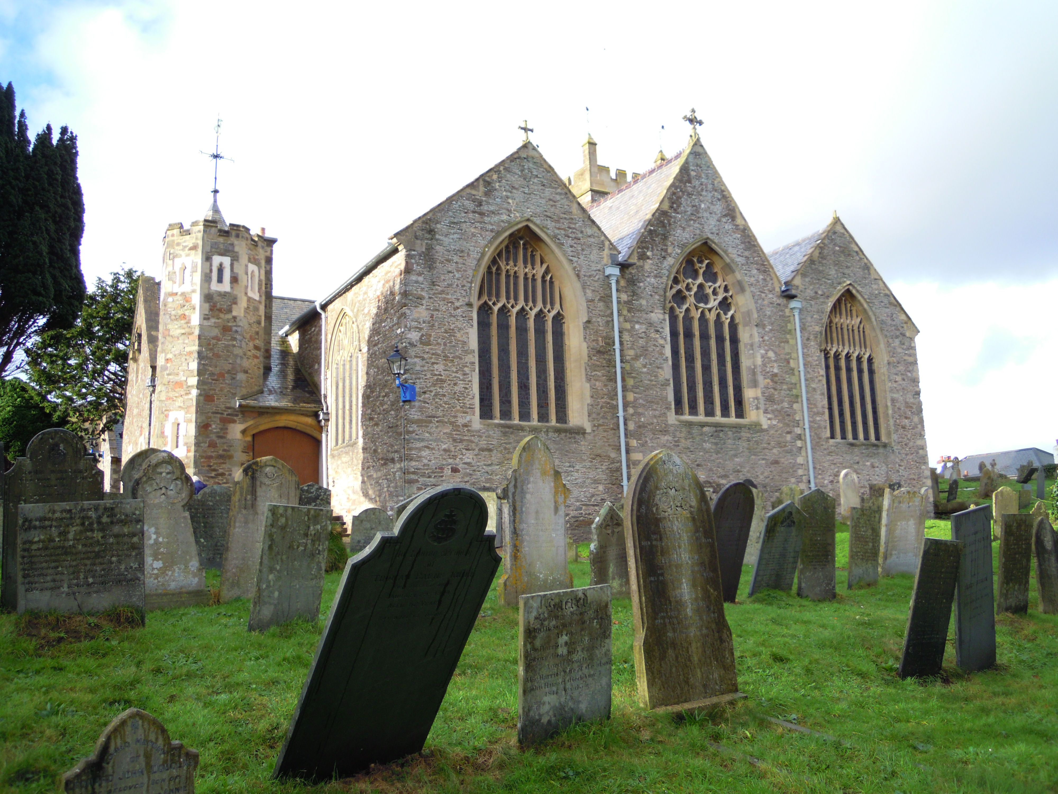
Holy Trinity Church, Ilfracombe

The Church of the Holy Trinity is the Anglican parish church for Ilfracombe in Devon. The building has been a Grade I listed building since 1951 and comes...

The Torrs

The Torrs are a Local Nature Reserve and one of the four main hills in the North Devon coastal town of Ilfracombe. The Park originally was designed in...

Ilfracombe Cemetery

Ilfracombe Cemetery (properly the Marlborough Road Cemetery) is the burial ground for the town of Ilfracombe in Devon in the United Kingdom. The cemetery...

Nearby Amenities

Located within 500m of 51.201144,-4.1321529
Doctors
Warwick Practice
Healthcare: doctor
Lat/Long: 51.203558/-4.1262566
Barrier: wall
Lat/Long: 51.2037534/-4.1370365
Give Way
Lat/Long: 51.2006566/-4.1273326
Ilfracombe
Historic Railway: station
Railway: site
Lat/Long: 51.2015864/-4.1280967
Ncn Milepost: mills
Sustrans Ref: MP773
Lat/Long: 51.1996066/-4.1269067
Sea Breeze
Tourism: guest_house
Lat/Long: 51.1999301/-4.1256867
Rainbow Ridge
Tourism: guest_house
Lat/Long: 51.2001469/-4.1257471
Generator Method: photovoltaic
Generator Output Electricity: yes
Generator Source: solar
Generator Type: solar_photovoltaic_panel
Location: roof
Power: generator
Lat/Long: 51.2014951/-4.1292809
Generator Method: photovoltaic
Generator Output Electricity: yes
Generator Source: solar
Generator Type: solar_photovoltaic_panel
Location: roof
Power: generator
Lat/Long: 51.201496/-4.129226
Generator Method: photovoltaic
Generator Output Electricity: yes
Generator Source: solar
Generator Type: solar_photovoltaic_panel
Location: roof
Power: generator
Lat/Long: 51.2027139/-4.1301312
Generator Method: photovoltaic
Generator Output Electricity: yes
Generator Source: solar
Generator Type: solar_photovoltaic_panel
Location: roof
Power: generator
Lat/Long: 51.2027005/-4.1302546
Generator Method: photovoltaic
Generator Output Electricity: yes
Generator Source: solar
Generator Type: solar_photovoltaic_panel
Location: roof
Power: generator
Lat/Long: 51.2027509/-4.132167
Generator Method: photovoltaic
Generator Output Electricity: yes
Generator Source: solar
Generator Type: solar_photovoltaic_panel
Location: roof
Power: generator
Lat/Long: 51.202645/-4.1321965
Generator Method: photovoltaic
Generator Output Electricity: yes
Generator Source: solar
Generator Type: solar_photovoltaic_panel
Location: roof
Power: generator
Lat/Long: 51.2022383/-4.1322421
Generator Method: photovoltaic
Generator Output Electricity: yes
Generator Source: solar
Generator Type: solar_photovoltaic_panel
Location: roof
Power: generator
Lat/Long: 51.2022299/-4.132285
Generator Method: photovoltaic
Generator Output Electricity: yes
Generator Source: solar
Generator Type: solar_photovoltaic_panel
Location: roof
Power: generator
Lat/Long: 51.202982/-4.1321777
Generator Method: photovoltaic
Generator Output Electricity: yes
Generator Source: solar
Generator Type: solar_photovoltaic_panel
Location: roof
Power: generator
Lat/Long: 51.2042377/-4.1294714
Generator Method: photovoltaic
Generator Output Electricity: yes
Generator Source: solar
Generator Type: solar_photovoltaic_panel
Location: roof
Power: generator
Lat/Long: 51.2047015/-4.1310592
Generator Method: photovoltaic
Generator Output Electricity: yes
Generator Source: solar
Generator Type: solar_photovoltaic_panel
Location: roof
Power: generator
Lat/Long: 51.2048477/-4.1304048
Generator Method: photovoltaic
Generator Output Electricity: yes
Generator Source: solar
Generator Type: solar_photovoltaic_panel
Location: roof
Power: generator
Lat/Long: 51.2053392/-4.1308795
Generator Method: photovoltaic
Generator Output Electricity: yes
Generator Source: solar
Generator Type: solar_photovoltaic_panel
Location: roof
Power: generator
Lat/Long: 51.205346/-4.1306998
Generator Method: photovoltaic
Generator Output Electricity: yes
Generator Source: solar
Generator Type: solar_photovoltaic_panel
Location: roof
Power: generator
Lat/Long: 51.2045719/-4.1275843
Generator Method: photovoltaic
Generator Output Electricity: yes
Generator Source: solar
Generator Type: solar_photovoltaic_panel
Location: roof
Power: generator
Lat/Long: 51.2045089/-4.1275266
Generator Method: photovoltaic
Generator Output Electricity: yes
Generator Source: solar
Generator Type: solar_photovoltaic_panel
Location: roof
Power: generator
Lat/Long: 51.2045509/-4.127595
Generator Method: photovoltaic
Generator Output Electricity: yes
Generator Source: solar
Generator Type: solar_photovoltaic_panel
Location: roof
Power: generator
Lat/Long: 51.2038749/-4.1319737
Generator Method: photovoltaic
Generator Output Electricity: yes
Generator Source: solar
Generator Type: solar_photovoltaic_panel
Location: roof
Power: generator
Lat/Long: 51.2038749/-4.1320273
Generator Method: photovoltaic
Generator Output Electricity: yes
Generator Source: solar
Generator Type: solar_photovoltaic_panel
Location: roof
Power: generator
Lat/Long: 51.2037522/-4.1331458
Generator Method: photovoltaic
Generator Output Electricity: yes
Generator Source: solar
Generator Type: solar_photovoltaic_panel
Location: roof
Power: generator
Lat/Long: 51.2007669/-4.1300921
Generator Method: photovoltaic
Generator Output Electricity: yes
Generator Source: solar
Generator Type: solar_photovoltaic_panel
Location: roof
Power: generator
Lat/Long: 51.2013391/-4.1320681
Generator Method: photovoltaic
Generator Output Electricity: yes
Generator Source: solar
Generator Type: solar_photovoltaic_panel
Location: roof
Power: generator
Lat/Long: 51.2013361/-4.132121
Generator Method: photovoltaic
Generator Output Electricity: yes
Generator Source: solar
Generator Type: solar_photovoltaic_panel
Location: roof
Power: generator
Lat/Long: 51.2014039/-4.1327603
Generator Method: photovoltaic
Generator Output Electricity: yes
Generator Source: solar
Generator Type: solar_photovoltaic_panel
Location: roof
Power: generator
Lat/Long: 51.2022547/-4.1339186
Generator Method: photovoltaic
Generator Output Electricity: yes
Generator Source: solar
Generator Type: solar_photovoltaic_panel
Location: roof
Power: generator
Lat/Long: 51.2013045/-4.1351587
Generator Method: photovoltaic
Generator Output Electricity: yes
Generator Source: solar
Generator Type: solar_photovoltaic_panel
Location: roof
Power: generator
Lat/Long: 51.2012518/-4.1352645
Generator Method: photovoltaic
Generator Output Electricity: yes
Generator Source: solar
Generator Type: solar_photovoltaic_panel
Location: roof
Power: generator
Lat/Long: 51.2013467/-4.135774
Generator Method: photovoltaic
Generator Output Electricity: yes
Generator Source: solar
Generator Type: solar_photovoltaic_panel
Location: roof
Power: generator
Lat/Long: 51.2013407/-4.1361681
Generator Method: photovoltaic
Generator Output Electricity: yes
Generator Source: solar
Generator Type: solar_photovoltaic_panel
Location: roof
Power: generator
Lat/Long: 51.2024369/-4.1348343
Give Way
Lat/Long: 51.2008418/-4.1270386
Street Lamp
Lat/Long: 51.2010318/-4.126936
Entrance: yes
Lat/Long: 51.2006973/-4.1277028
Barrier: lift_gate
Lat/Long: 51.200689/-4.1274321
Crossing
Crossing: uncontrolled
Lat/Long: 51.2006973/-4.1274577
Street Lamp
Lat/Long: 51.2043009/-4.1272934
Board Type: history
Information: board
Tourism: information
Lat/Long: 51.1981416/-4.1271874
Image: https://archive.org/details/ilfracombe-2021-09-08/DSCN5210.JPG
Leisure: picnic_table
Lat/Long: 51.198425/-4.1269165
Street Lamp
Lat/Long: 51.2011429/-4.1257152
Street Lamp
Lat/Long: 51.2007658/-4.1256545
Street Lamp
Lat/Long: 51.2004204/-4.1255982
Addr Housenumber: 28
Addr Street: Belmont Road
Lat/Long: 51.2023889/-4.1284534
Bus Stop
Bus: yes
Naptan AtcoCode: 1100DEA10977
Naptan NaptanCode: dvnajtmg
Public Transport: platform
Shelter: no
Lat/Long: 51.2027947/-4.1262118
Addr Housenumber: 63A
Addr Street: Saint Brannock's Road
Lat/Long: 51.2016544/-4.1259898
Bus Stop
Bench: no
Bus: yes
Passenger Information Display: no
Public Transport: platform
Shelter: no
Lat/Long: 51.2009353/-4.1256616
Post Box
Operator: Royal Mail
Operator Wikidata: Q638098
Post Box Type: wall
Lat/Long: 51.2009219/-4.1256804
Fire Hydrant
Emergency: fire_hydrant
Fire Hydrant Type: underground
Lat/Long: 51.2008948/-4.1256572
Give Way
Lat/Long: 51.2027542/-4.1286834
Bus Stop
Bus: yes
Naptan AtcoCode: 1100DEA10979
Naptan NaptanCode: dvnajtdt
Public Transport: platform
Shelter: no
Lat/Long: 51.2027548/-4.1282087
Post Box
Operator: Royal Mail
Operator Wikidata: Q638098
Post Box Type: wall
Royal Cypher: EIIR
Royal Cypher Wikidata: Q33102113
Lat/Long: 51.2028215/-4.1274169
Bench
Lat/Long: 51.2028283/-4.127395
Give Way
Lat/Long: 51.2028598/-4.1272726
Addr Housenumber: 97
Addr Street: Saint Brannock's Road
Lat/Long: 51.2038346/-4.1268066
Addr Housenumber: 18A
Addr Street: Station Road
Lat/Long: 51.2039514/-4.1270909
Street Lamp
Lat/Long: 51.2004471/-4.125356
Bus Stop
Bus: yes
Public Transport: platform
Lat/Long: 51.2005638/-4.1254908
Bench
Lat/Long: 51.200583/-4.1254232
Bus Stop
Bin: yes
Bus: yes
Public Transport: platform
Shelter: yes
Lat/Long: 51.2028586/-4.1261306
Bench
Lat/Long: 51.2032981/-4.1263117
The data included in this document is from www.openstreetmap.org. The data is made available under ODbL.

Have you been to Langleigh?

Leave your review of Langleigh below (or comments, questions and feedback).