Great Fossend

Settlement in Devon Mid Devon

England

Great Fossend

Ordnance Survey Cut Mark This OS cut mark can be found on the east parapet of the bridge. It marks a point 119.247m above mean sea level.
Ordnance Survey Cut Mark Credit: Adrian Dust

Great Fossend is a small rural village located in the county of Devon, England. Situated amidst the picturesque countryside, it offers a tranquil and idyllic setting for its residents and visitors alike.

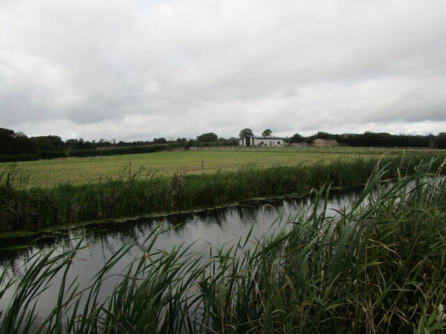
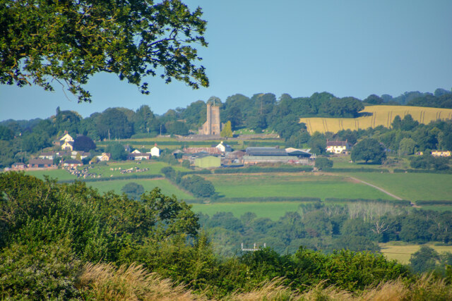
The village is nestled within rolling hills and verdant farmland, providing breathtaking views of the surrounding landscape. It is characterized by charming traditional cottages and farmhouses, which add to its quintessential English countryside atmosphere.

Although Great Fossend is a relatively small village, it boasts a strong sense of community. The villagers are known for their warm and friendly nature, and often come together for various events and activities. The local community center serves as a hub for social gatherings, where residents can participate in clubs and organizations catering to different interests.

Nature enthusiasts will find Great Fossend particularly appealing, as it is surrounded by numerous walking and hiking trails. The village is also located in close proximity to several nature reserves and parks, offering opportunities for outdoor adventures and wildlife spotting.

Despite its rural setting, Great Fossend benefits from good transport links. The nearby town provides access to essential amenities such as shops, schools, and medical facilities. Additionally, the village is well-connected to major road networks, allowing for convenient travel to nearby towns and cities.

Overall, Great Fossend offers a peaceful and charming retreat in the heart of the Devon countryside, making it an ideal destination for those seeking a slower pace of life and a closer connection with nature.

If you have any feedback on the listing, please let us know in the comments section below.

Great Fossend Images

Images are sourced within 2km of 50.944824/-3.3240383 or Grid Reference ST0716. Thanks to Geograph Open Source API. All images are credited.

Ordnance Survey Cut Mark This OS cut mark can be found on the east parapet of the bridge. It marks a point 119.247m above mean sea level.
Ordnance Survey Cut Mark
This OS cut mark can be found on the east parapet of the bridge. It marks a point 119.247m above mean sea level.
Westcott Bridge, Grand Western Canal
Grand Western Canal and Ley Barn
Black Bridge Carried a mineral railway serving Westleigh Quarry. Now carries a footpath.
The railway replaced a tramway in 1892.
Black Bridge
Carried a mineral railway serving Westleigh Quarry. Now carries a footpath. The railway replaced a tramway in 1892.
The Grand Western Canal at Great Fossend
Grass field near Burlescombe The M5 visible in the valley below.
Grass field near Burlescombe
The M5 visible in the valley below.
Towpath alongside the Grand Western Canal
Burlescombe : Grand Western Canal The canal heading through the countryside.
Burlescombe : Grand Western Canal
The canal heading through the countryside.
Burlescombe : Grand Western Canal Underneath a bridge.
Burlescombe : Grand Western Canal
Underneath a bridge.
Burlescombe : Grand Western Canal Looking towards Fenacre Bridge.
Burlescombe : Grand Western Canal
Looking towards Fenacre Bridge.
Burlescombe : Grand Western Canal The canal heading through the countryside.
Burlescombe : Grand Western Canal
The canal heading through the countryside.
Sampford Peverell : Countryside Scenery Looking towards Burlescombe.
Sampford Peverell : Countryside Scenery
Looking towards Burlescombe.
Burlescombe : The M5 Motorway Looking along the M5.
Burlescombe : The M5 Motorway
Looking along the M5.
Burlescombe : Grand Western Canal - Black Bridge Black Bridge is an old mineral line bridge across which limestone was transported to the railway line further up in the village.
Burlescombe : Grand Western Canal - Black Bridge
Black Bridge is an old mineral line bridge across which limestone was transported to the railway line further up in the village.
Burlescombe : Grassy Field A grassy field in the countryside.
Burlescombe : Grassy Field
A grassy field in the countryside.
Burlescombe : Grand Western Canal - Black Bridge Crossing Black Bridge.
Burlescombe : Grand Western Canal - Black Bridge
Crossing Black Bridge.
Burlescombe : Grand Western Canal Looking along the canal.
Burlescombe : Grand Western Canal
Looking along the canal.
Grand Western Canal Canal at Westcott Bridge, near Ayshford.
Grand Western Canal
Canal at Westcott Bridge, near Ayshford.
Show me another place!

Great Fossend is located at Grid Ref: ST0716 (Lat: 50.944824, Lng: -3.3240383)

Administrative County: Devon

District: Mid Devon

Police Authority: Devon and Cornwall

What 3 Words

///scores.disgraced.hunt. Near Uffculme, Devon

Related Wikis

Canonsleigh Abbey

Canonsleigh Abbey was an Augustinian priory in the parish of Burlescombe, Devon. == History == It was founded in about 1170 by Walter de Claville, lord...

Burlescombe

Burlescombe (, bur-LES-kəm) is a village and civil parish in the Mid Devon district of Devon, England. The parish is surrounded, clockwise from the north...

Holcombe Rogus

Holcombe Rogus is a village, civil parish and ecclesiastical parish in the English county of Devon. In 2001 the population of the parish was 503. ��2...

Manor of Holcombe Rogus

Holcombe Rogus is a historic manor in the parish of Holcombe Rogus in Devon, England. The present grade I listed Tudor manor house known as Holcombe Court...

Appledore, Mid Devon

Appledore is a small village near Uffculme in Devon, England, about 7 miles (11 kilometres) east of Tiverton.Appledore was listed in the Domesday Book...

Ayshford Chapel

Ayshford Chapel is a former private chapel in the village of Ayshford, in the parish of Burlescombe, Devon, England. It is recorded in the National Heritage...

Greenham Hall

Greenham Hall is a country house at Wellington in Somerset. It was once the home of Admiral of the Fleet Sir John Kelly. It is a Grade II listed building...

Culmstock

Culmstock is a village and civil parish in Mid Devon, England, centred 10 miles from Tiverton and 6 NE of Cullompton. It is laid out on both sides of the...

Nearby Amenities

Located within 500m of 50.944824,-3.3240383
Building: public
Lat/Long: 50.9438553/-3.3209559
Burlescombe
Place: village
Lat/Long: 50.9447577/-3.321606
Colour: gray
Design: three-level
Line Attachment: suspension
Material: metal
Operator: National Grid
Operator Wikidata: Q1465461
Power: tower
Structure: lattice
Lat/Long: 50.9449173/-3.3287726
Colour: gray
Design: three-level
Line Attachment: suspension
Material: metal
Operator: National Grid
Operator Wikidata: Q1465461
Power: tower
Structure: lattice
Lat/Long: 50.9472236/-3.3262727
Canonsleigh Priory
Historic: ruins
Lat/Long: 50.9485767/-3.3277108
Tourism: picnic_site
Lat/Long: 50.9439375/-3.3239911
Brand: National Grid
Brand Wikidata: Q1465461
Design: h-frame
Guyed: yes
Material: wood
Operator: National Grid Electricity Distribution
Operator Old: Western Power Distribution
Operator Wikidata: Q7988183
Owner: National Grid Electricity Distribution (South West) Plc
Owner Wikidata: Q114397866
Power: pole
Lat/Long: 50.9469301/-3.3271086
Power: pole
Lat/Long: 50.9480623/-3.3250085
Power: pole
Lat/Long: 50.9491641/-3.3227259
Brand: National Grid
Brand Wikidata: Q1465461
Material: wood
Operator: National Grid Electricity Distribution
Operator Old: Western Power Distribution
Operator Wikidata: Q7988183
Owner: National Grid Electricity Distribution (South West) Plc
Owner Wikidata: Q114397866
Power: pole
Lat/Long: 50.9472089/-3.3282378
Power: pole
Lat/Long: 50.9476669/-3.3272401
Power: pole
Lat/Long: 50.9474523/-3.3262423
Power: pole
Lat/Long: 50.9465076/-3.3174768
Power: pole
Lat/Long: 50.9465228/-3.3187133
Power: pole
Lat/Long: 50.9465194/-3.3201268
Power: pole
Lat/Long: 50.946516/-3.3209798
Power: pole
Lat/Long: 50.9465566/-3.3220768
Power: pole
Lat/Long: 50.9466698/-3.3246464
Brand: National Grid
Brand Wikidata: Q1465461
Guyed: yes
Material: wood
Operator: National Grid Electricity Distribution
Operator Old: Western Power Distribution
Operator Wikidata: Q7988183
Owner: National Grid Electricity Distribution (South West) Plc
Owner Wikidata: Q114397866
Power: pole
Lat/Long: 50.9467374/-3.3259473
Power: pole
Lat/Long: 50.9474607/-3.3196011
Power: pole
Lat/Long: 50.9473323/-3.321071
Power: pole
Lat/Long: 50.9472123/-3.3227339
Power: pole
Lat/Long: 50.9471599/-3.3235037
Brand: National Grid
Brand Wikidata: Q1465461
Design: h-frame
Guyed: yes
Material: wood
Operator: National Grid Electricity Distribution
Operator Old: Western Power Distribution
Operator Wikidata: Q7988183
Owner: National Grid Electricity Distribution (South West) Plc
Owner Wikidata: Q114397866
Power: pole
Lat/Long: 50.9470264/-3.3254591
Brand: National Grid
Brand Wikidata: Q1465461
Location Transition: yes
Material: wood
Operator: National Grid Electricity Distribution
Operator Old: Western Power Distribution
Operator Wikidata: Q7988183
Owner: National Grid Electricity Distribution (South West) Plc
Owner Wikidata: Q114397866
Power: pole
Lat/Long: 50.9454125/-3.3288628
Brand: National Grid
Brand Wikidata: Q1465461
Material: wood
Operator: National Grid Electricity Distribution
Operator Old: Western Power Distribution
Operator Wikidata: Q7988183
Owner: National Grid Electricity Distribution (South West) Plc
Owner Wikidata: Q114397866
Power: pole
Lat/Long: 50.9446368/-3.3298847
Brand: National Grid
Brand Wikidata: Q1465461
Design: h-frame
Guyed: yes
Material: wood
Operator: National Grid Electricity Distribution
Operator Old: Western Power Distribution
Operator Wikidata: Q7988183
Owner: National Grid Electricity Distribution (South West) Plc
Owner Wikidata: Q114397866
Power: pole
Lat/Long: 50.9468963/-3.3270791
Brand: National Grid
Brand Wikidata: Q1465461
Design: h-frame
Guyed: yes
Material: wood
Operator: National Grid Electricity Distribution
Operator Old: Western Power Distribution
Operator Wikidata: Q7988183
Owner: National Grid Electricity Distribution (South West) Plc
Owner Wikidata: Q114397866
Power: pole
Lat/Long: 50.9470171/-3.3274292
Generator Method: photovoltaic
Generator Output Electricity: yes
Generator Source: solar
Generator Type: solar_photovoltaic_panel
Location: roof
Power: generator
Lat/Long: 50.9442253/-3.3206445
Power: pole
Lat/Long: 50.9483901/-3.3270228
Power: pole
Lat/Long: 50.9470416/-3.3274157
Power: pole
Lat/Long: 50.9467645/-3.3293268
Power: pole
Lat/Long: 50.9463809/-3.3276799
Power: pole
Lat/Long: 50.9473982/-3.3291471
The data included in this document is from www.openstreetmap.org. The data is made available under ODbL.

Have you been to Great Fossend?

Leave your review of Great Fossend below (or comments, questions and feedback).