Elmington
Settlement in Northamptonshire
England
Elmington

Elmington is a small village located in the county of Northamptonshire, England. Situated approximately 6 miles north of the town of Northampton, Elmington falls within the district of South Northamptonshire. The village is nestled amidst scenic countryside and boasts a tranquil and picturesque setting.
With a population of around 500 residents, Elmington is a close-knit community known for its friendly atmosphere and strong community spirit. The village is primarily residential, with a mix of traditional cottages and more modern houses. The architecture reflects the village's long history, with some buildings dating back several centuries.
Elmington benefits from its proximity to Northampton, which provides residents with access to a wider range of amenities, including schools, shops, and healthcare facilities. The village itself, however, is home to a local pub and a village hall, which serves as a central hub for community activities.
The surrounding countryside offers ample opportunities for outdoor pursuits, such as walking, hiking, and cycling. Elmington is also within close proximity to several nature reserves and parks, providing residents with ample green spaces to enjoy.
Transport links in Elmington are primarily road-based, with the A428 running nearby, connecting the village to Northampton and other surrounding towns. The nearest railway station is located in Northampton, providing further connectivity to the wider region.
Overall, Elmington offers a peaceful and charming place to live, with a strong sense of community and easy access to both rural and urban amenities.
If you have any feedback on the listing, please let us know in the comments section below.
Elmington Images
Images are sourced within 2km of 52.494756/-0.4503698 or Grid Reference TL0589. Thanks to Geograph Open Source API. All images are credited.


![Oundle buildings [1] Set in the middle of Market Place, the town hall was built in 1830. The ground floor was originally open as a market. Constructed of ashlar under a Welsh slate roof. Listed, grade II, with details at: <span class="nowrap"><a title="https://historicengland.org.uk/listing/the-list/list-entry/1372119" rel="nofollow ugc noopener" href="https://historicengland.org.uk/listing/the-list/list-entry/1372119">Link</a><img style="margin-left:2px;" alt="External link" title="External link - shift click to open in new window" src="https://s1.geograph.org.uk/img/external.png" width="10" height="10"/></span>
Oundle is a market town in North Northamptonshire, some 69 miles (111 kilometres) north of London and 12 miles (19 km) southwest of Peterborough. The town is located on the left bank of the River Nene. The area has been occupied for thousands of years as evidenced by finds of prehistoric and Bronze Age, Iron Age and Roman materials. The town is home to Oundle School, founded in 1556.](https://s0.geograph.org.uk/geophotos/07/15/91/7159112_0de2e2cf.jpg)
![Oundle buildings [2] Number 1 Market Place is on the corner of New Street and has fronts to both. Built in the 18th century of coursed rubble stone under a stone slate roof. Listed, grade II, with details at: <span class="nowrap"><a title="https://historicengland.org.uk/listing/the-list/list-entry/1190542" rel="nofollow ugc noopener" href="https://historicengland.org.uk/listing/the-list/list-entry/1190542">Link</a><img style="margin-left:2px;" alt="External link" title="External link - shift click to open in new window" src="https://s1.geograph.org.uk/img/external.png" width="10" height="10"/></span>
Oundle is a market town in North Northamptonshire, some 69 miles (111 kilometres) north of London and 12 miles (19 km) southwest of Peterborough. The town is located on the left bank of the River Nene. The area has been occupied for thousands of years as evidenced by finds of prehistoric and Bronze Age, Iron Age and Roman materials. The town is home to Oundle School, founded in 1556.](https://s1.geograph.org.uk/geophotos/07/15/91/7159129_0755b471.jpg)
![Oundle buildings [3] Numbers 2 and 2A Market Place was built in the 17th century. Constructed of coursed rubble stone with freestone quoins. The shopfront is mid 19th century. Listed, grade II, with details at: <span class="nowrap"><a title="https://historicengland.org.uk/listing/the-list/list-entry/1372121" rel="nofollow ugc noopener" href="https://historicengland.org.uk/listing/the-list/list-entry/1372121">Link</a><img style="margin-left:2px;" alt="External link" title="External link - shift click to open in new window" src="https://s1.geograph.org.uk/img/external.png" width="10" height="10"/></span>
Oundle is a market town in North Northamptonshire, some 69 miles (111 kilometres) north of London and 12 miles (19 km) southwest of Peterborough. The town is located on the left bank of the River Nene. The area has been occupied for thousands of years as evidenced by finds of prehistoric and Bronze Age, Iron Age and Roman materials. The town is home to Oundle School, founded in 1556.](https://s1.geograph.org.uk/geophotos/07/15/91/7159133_22a13721.jpg)
![Oundle buildings [4] Numbers 3 and 5 Market Place were built in the late 18th century. Constructed of coursed rubble stone under a stone slate roof. The shopfronts are 19th century.
Listed, grade II, with details at: <span class="nowrap"><a title="https://historicengland.org.uk/listing/the-list/list-entry/1039854" rel="nofollow ugc noopener" href="https://historicengland.org.uk/listing/the-list/list-entry/1039854">Link</a><img style="margin-left:2px;" alt="External link" title="External link - shift click to open in new window" src="https://s1.geograph.org.uk/img/external.png" width="10" height="10"/></span>
Oundle is a market town in North Northamptonshire, some 69 miles (111 kilometres) north of London and 12 miles (19 km) southwest of Peterborough. The town is located on the left bank of the River Nene. The area has been occupied for thousands of years as evidenced by finds of prehistoric and Bronze Age, Iron Age and Roman materials. The town is home to Oundle School, founded in 1556.](https://s1.geograph.org.uk/geophotos/07/15/91/7159137_b339019b.jpg)
![Oundle buildings [5] Numbers 7 and 9 Market Place are a range of three late 18th century houses now in commercial use. Seen here is the left section of the range, the central section is seen at <a href="https://www.geograph.org.uk/photo/7159928">TL0488 : Oundle buildings [6]</a> and the right section is seen at <a href="https://www.geograph.org.uk/photo/7159929">TL0488 : Oundle buildings [7]</a>. Constructed of coursed rubble stone with an ashlar front under a stone slate roof. The left section has a 19th century shopfront, the central section has a Gothic bank front. Listed, grade II, with details at: <span class="nowrap"><a title="https://historicengland.org.uk/listing/the-list/list-entry/1190555" rel="nofollow ugc noopener" href="https://historicengland.org.uk/listing/the-list/list-entry/1190555">Link</a><img style="margin-left:2px;" alt="External link" title="External link - shift click to open in new window" src="https://s1.geograph.org.uk/img/external.png" width="10" height="10"/></span>
Oundle is a market town in North Northamptonshire, some 69 miles (111 kilometres) north of London and 12 miles (19 km) southwest of Peterborough. The town is located on the left bank of the River Nene. The area has been occupied for thousands of years as evidenced by finds of prehistoric and Bronze Age, Iron Age and Roman materials. The town is home to Oundle School, founded in 1556.](https://s3.geograph.org.uk/geophotos/07/15/99/7159927_bb9e9719.jpg)
![Oundle buildings [6] Numbers 7 and 9 Market Place are a range of three late 18th century houses now in commercial use. Seen here is the central section of the range, the left section is seen at <a href="https://www.geograph.org.uk/photo/7159927">TL0488 : Oundle buildings [5]</a> and the right section is seen at <a href="https://www.geograph.org.uk/photo/7159929">TL0488 : Oundle buildings [7]</a>. Constructed of coursed rubble stone with an ashlar front under a stone slate roof. The left section has a 19th century shopfront, the central section has a Gothic bank front. Listed, grade II, with details at: <span class="nowrap"><a title="https://historicengland.org.uk/listing/the-list/list-entry/1190555" rel="nofollow ugc noopener" href="https://historicengland.org.uk/listing/the-list/list-entry/1190555">Link</a><img style="margin-left:2px;" alt="External link" title="External link - shift click to open in new window" src="https://s1.geograph.org.uk/img/external.png" width="10" height="10"/></span>
Oundle is a market town in North Northamptonshire, some 69 miles (111 kilometres) north of London and 12 miles (19 km) southwest of Peterborough. The town is located on the left bank of the River Nene. The area has been occupied for thousands of years as evidenced by finds of prehistoric and Bronze Age, Iron Age and Roman materials. The town is home to Oundle School, founded in 1556.](https://s0.geograph.org.uk/geophotos/07/15/99/7159928_60ad9326.jpg)
![Oundle buildings [7] Numbers 7 and 9 Market Place are a range of three late 18th century houses now in commercial use. Seen here is the right section of the range, the central section is seen at <a href="https://www.geograph.org.uk/photo/7159927">TL0488 : Oundle buildings [5]</a> and the left section is seen at <a href="https://www.geograph.org.uk/photo/7159928">TL0488 : Oundle buildings [6]</a>. Constructed of coursed rubble stone with an ashlar front under a stone slate roof. The left section has a 19th century shopfront, the central section has a Gothic bank front. Listed, grade II, with details at: <span class="nowrap"><a title="https://historicengland.org.uk/listing/the-list/list-entry/1190555" rel="nofollow ugc noopener" href="https://historicengland.org.uk/listing/the-list/list-entry/1190555">Link</a><img style="margin-left:2px;" alt="External link" title="External link - shift click to open in new window" src="https://s1.geograph.org.uk/img/external.png" width="10" height="10"/></span>
Oundle is a market town in North Northamptonshire, some 69 miles (111 kilometres) north of London and 12 miles (19 km) southwest of Peterborough. The town is located on the left bank of the River Nene. The area has been occupied for thousands of years as evidenced by finds of prehistoric and Bronze Age, Iron Age and Roman materials. The town is home to Oundle School, founded in 1556.](https://s1.geograph.org.uk/geophotos/07/15/99/7159929_4f700243.jpg)
![Oundle buildings [8] The Rose and Crown public house, number 11 Market Place, was originally built in the 17th century and refronted in the early 19th century. Constructed of coursed rubble stone with an ashlar front under a stone slate roof. Listed, grade II, with details at: <span class="nowrap"><a title="https://historicengland.org.uk/listing/the-list/list-entry/1039855" rel="nofollow ugc noopener" href="https://historicengland.org.uk/listing/the-list/list-entry/1039855">Link</a><img style="margin-left:2px;" alt="External link" title="External link - shift click to open in new window" src="https://s1.geograph.org.uk/img/external.png" width="10" height="10"/></span>
Oundle is a market town in North Northamptonshire, some 69 miles (111 kilometres) north of London and 12 miles (19 km) southwest of Peterborough. The town is located on the left bank of the River Nene. The area has been occupied for thousands of years as evidenced by finds of prehistoric and Bronze Age, Iron Age and Roman materials. The town is home to Oundle School, founded in 1556.](https://s0.geograph.org.uk/geophotos/07/15/99/7159932_3a45345b.jpg)
![Oundle buildings [9] Number 13 Market Place was built in the late 17th century. The colonnade has pillars supporting a massive wooden lintel. Constructed of coursed rubble stone with an ashlar front under a stone slate roof. Listed, grade II*, with details at: <span class="nowrap"><a title="https://historicengland.org.uk/listing/the-list/list-entry/1372120" rel="nofollow ugc noopener" href="https://historicengland.org.uk/listing/the-list/list-entry/1372120">Link</a><img style="margin-left:2px;" alt="External link" title="External link - shift click to open in new window" src="https://s1.geograph.org.uk/img/external.png" width="10" height="10"/></span>
Oundle is a market town in North Northamptonshire, some 69 miles (111 kilometres) north of London and 12 miles (19 km) southwest of Peterborough. The town is located on the left bank of the River Nene. The area has been occupied for thousands of years as evidenced by finds of prehistoric and Bronze Age, Iron Age and Roman materials. The town is home to Oundle School, founded in 1556.](https://s3.geograph.org.uk/geophotos/07/15/99/7159935_919de76f.jpg)
![Oundle features [1] These attractive gates are between numbers 13 and 15 Market Place.
Oundle is a market town in North Northamptonshire, some 69 miles (111 kilometres) north of London and 12 miles (19 km) southwest of Peterborough. The town is located on the left bank of the River Nene. The area has been occupied for thousands of years as evidenced by finds of prehistoric and Bronze Age, Iron Age and Roman materials. The town is home to Oundle School, founded in 1556.](https://s0.geograph.org.uk/geophotos/07/15/99/7159936_60d35076.jpg)
![Oundle buildings [10] Number 14 Market Place is a 17th century house with a shopfront inserted. Constructed of coursed rubble stone under a stone slate roof. Listed, grade II, with details at: <span class="nowrap"><a title="https://historicengland.org.uk/listing/the-list/list-entry/1190592" rel="nofollow ugc noopener" href="https://historicengland.org.uk/listing/the-list/list-entry/1190592">Link</a><img style="margin-left:2px;" alt="External link" title="External link - shift click to open in new window" src="https://s1.geograph.org.uk/img/external.png" width="10" height="10"/></span>
Oundle is a market town in North Northamptonshire, some 69 miles (111 kilometres) north of London and 12 miles (19 km) southwest of Peterborough. The town is located on the left bank of the River Nene. The area has been occupied for thousands of years as evidenced by finds of prehistoric and Bronze Age, Iron Age and Roman materials. The town is home to Oundle School, founded in 1556.](https://s1.geograph.org.uk/geophotos/07/15/99/7159937_00bf2761.jpg)
![Oundle buildings [11] Numbers 18, 18A and 20 Market Place is a long 17th century house now shops. Constructed of coursed rubble stone under a stone slate roof. Listed, grade II, with details at: <span class="nowrap"><a title="https://historicengland.org.uk/listing/the-list/list-entry/1372122" rel="nofollow ugc noopener" href="https://historicengland.org.uk/listing/the-list/list-entry/1372122">Link</a><img style="margin-left:2px;" alt="External link" title="External link - shift click to open in new window" src="https://s1.geograph.org.uk/img/external.png" width="10" height="10"/></span>
Oundle is a market town in North Northamptonshire, some 69 miles (111 kilometres) north of London and 12 miles (19 km) southwest of Peterborough. The town is located on the left bank of the River Nene. The area has been occupied for thousands of years as evidenced by finds of prehistoric and Bronze Age, Iron Age and Roman materials. The town is home to Oundle School, founded in 1556.](https://s0.geograph.org.uk/geophotos/07/15/99/7159940_b4337b36.jpg)
![Oundle buildings [12] Numbers 22 and 24 Market Place were built, probably, in the late 17th century of coursed rubble stone, number 22 has a Welsh slate roof, number 24 a stone slate roof. Number 22 has a modern shopfront, number 24 has had its 19th century shopfront removed. Listed, grade II, with details at: <span class="nowrap"><a title="https://historicengland.org.uk/listing/the-list/list-entry/1039858" rel="nofollow ugc noopener" href="https://historicengland.org.uk/listing/the-list/list-entry/1039858">Link</a><img style="margin-left:2px;" alt="External link" title="External link - shift click to open in new window" src="https://s1.geograph.org.uk/img/external.png" width="10" height="10"/></span>
Oundle is a market town in North Northamptonshire, some 69 miles (111 kilometres) north of London and 12 miles (19 km) southwest of Peterborough. The town is located on the left bank of the River Nene. The area has been occupied for thousands of years as evidenced by finds of prehistoric and Bronze Age, Iron Age and Roman materials. The town is home to Oundle School, founded in 1556.](https://s1.geograph.org.uk/geophotos/07/15/99/7159945_7340f766.jpg)
![Oundle buildings [13] Bramston House is one of Oundle School&#039;s boarding houses. The West Wing is seen here, the central section is seen at <a href="https://www.geograph.org.uk/photo/7159955">TL0488 : Oundle buildings [14]</a> and the East Wing is at <a href="https://www.geograph.org.uk/photo/7159957">TL0488 : Oundle buildings [15]</a>. The West Wing was built in the early 18th century and is constructed of ashlar under a stone slate roof. Listed, grade II*, with details at: <span class="nowrap"><a title="https://historicengland.org.uk/listing/the-list/list-entry/1190599" rel="nofollow ugc noopener" href="https://historicengland.org.uk/listing/the-list/list-entry/1190599">Link</a><img style="margin-left:2px;" alt="External link" title="External link - shift click to open in new window" src="https://s1.geograph.org.uk/img/external.png" width="10" height="10"/></span>
Oundle is a market town in North Northamptonshire, some 69 miles (111 kilometres) north of London and 12 miles (19 km) southwest of Peterborough. The town is located on the left bank of the River Nene. The area has been occupied for thousands of years as evidenced by finds of prehistoric and Bronze Age, Iron Age and Roman materials. The town is home to Oundle School, founded in 1556.](https://s0.geograph.org.uk/geophotos/07/15/99/7159952_fba5ab89.jpg)
![Oundle buildings [14] Bramston House is one of Oundle School&#039;s boarding houses. The central section is seen here, the West Wing is seen at <a href="https://www.geograph.org.uk/photo/7159952">TL0488 : Oundle buildings [13]</a> and the East Wing is at <a href="https://www.geograph.org.uk/photo/7159957">TL0488 : Oundle buildings [15]</a>. The central section was built in the late 17th century and is constructed of ashlar under a stone slate roof. Listed, grade II*, with details at: <span class="nowrap"><a title="https://historicengland.org.uk/listing/the-list/list-entry/1039859" rel="nofollow ugc noopener" href="https://historicengland.org.uk/listing/the-list/list-entry/1039859">Link</a><img style="margin-left:2px;" alt="External link" title="External link - shift click to open in new window" src="https://s1.geograph.org.uk/img/external.png" width="10" height="10"/></span>
Oundle is a market town in North Northamptonshire, some 69 miles (111 kilometres) north of London and 12 miles (19 km) southwest of Peterborough. The town is located on the left bank of the River Nene. The area has been occupied for thousands of years as evidenced by finds of prehistoric and Bronze Age, Iron Age and Roman materials. The town is home to Oundle School, founded in 1556.](https://s3.geograph.org.uk/geophotos/07/15/99/7159955_4693b7d2.jpg)
Elmington is located at Grid Ref: TL0589 (Lat: 52.494756, Lng: -0.4503698)
Unitary Authority: North Northamptonshire
Police Authority: Northamptonshire
What 3 Words
///fidelity.clan.fleet. Near Oundle, Northamptonshire
Nearby Locations
Related Wikis
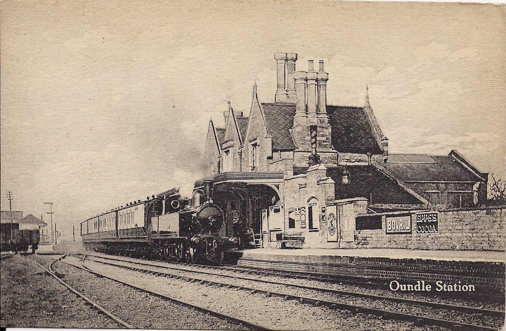
Oundle railway station
Oundle railway station is a Grade II listed former railway station in Oundle, Northamptonshire on the former Northampton and Peterborough Railway line...

Nene Way
The Nene Way is a waymarked long-distance footpath in England running through the English counties of Northamptonshire, Cambridgeshire and Lincolnshire...

Cotterstock
Cotterstock is a village and civil parish in North Northamptonshire, England. The population of the civil parish at the 2011 census was 153. == Geography... ==

Tansor
Tansor is a village and civil parish in the English county of Northamptonshire. Lying near the River Nene, three miles north-east of the town of Oundle...
Ashton, North Northamptonshire
Ashton is a village and civil parish about ¾ mile east of Oundle in the east of the English county of Northamptonshire forming part of the unitary authority...
Oundle and Thrapston Rural District
Oundle and Thrapston was a rural district in Northamptonshire, England from 1935 to 1974. It was formed in 1935 under the County Review Order as a merger...
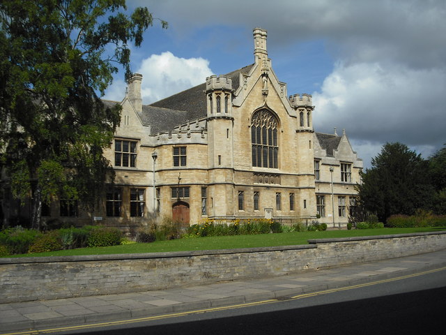
Oundle School
Oundle School is a public school (English private boarding and day school) for pupils 11–18 situated in the market town of Oundle in Northamptonshire...
Oundle International Festival
Oundle International Festival (OIF) is an annual community arts festival and organ school (ages 14 to 24) held in Oundle, England.The festival was founded...
Nearby Amenities
Located within 500m of 52.494756,-0.4503698Have you been to Elmington?
Leave your review of Elmington below (or comments, questions and feedback).