Cocklaw

Settlement in Northumberland

England

Cocklaw

St Peter's church, Humshaugh
St Peter's church, Humshaugh Credit: David Purchase

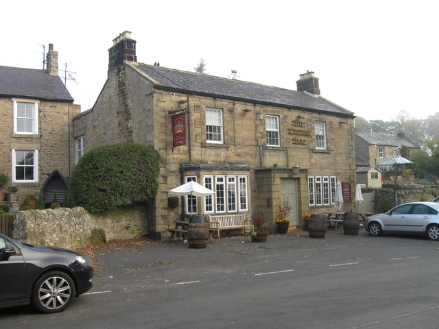
Cocklaw is a small village located in Northumberland, England. It is situated near the town of Alnwick and is surrounded by picturesque countryside and rolling hills. The village is known for its quaint charm and traditional architecture, with many of the buildings dating back to the 18th and 19th centuries.

Cocklaw is a close-knit community with a population of approximately 200 residents. The village has a few amenities, including a pub, a village hall, and a small shop. Residents often gather at the pub to socialize and catch up with their neighbors.

The village is surrounded by beautiful countryside, making it a popular destination for hikers and nature enthusiasts. There are several walking trails that lead through the surrounding fields and woodlands, offering stunning views of the Northumberland countryside.

Overall, Cocklaw is a peaceful and idyllic village that offers a quiet retreat from the hustle and bustle of city life. Its charming atmosphere and natural beauty make it a popular destination for those looking to escape the stresses of everyday life.

If you have any feedback on the listing, please let us know in the comments section below.

Cocklaw Images

Images are sourced within 2km of 55.035236/-2.0962237 or Grid Reference NY9371. Thanks to Geograph Open Source API. All images are credited.

St Peter's church, Humshaugh
Ordnance Survey 1GL Bolt This OS Bolt can be found on the west face of St Giles Church. It marks a point 77.962m above mean sea level.
Ordnance Survey 1GL Bolt
This OS Bolt can be found on the west face of St Giles Church. It marks a point 77.962m above mean sea level.
The Crown Inn
The Crown Inn
Graveyard
Graveyard
Humshaugh (former) station, with Special DMU, 1957 View northward on the ex-NBR Border Counties (Hexham - Riccarton Junction) line.  The station (Chollerford until 1/8/19) and line had been closed for passengers since 15/10/56, but was still open for goods (until 1/9/58). This was a Special run for the Institute of Transport of a new Metropolitan-Cammell four-car DMU.
Humshaugh (former) station, with Special DMU, 1957
View northward on the ex-NBR Border Counties (Hexham - Riccarton Junction) line. The station (Chollerford until 1/8/19) and line had been closed for passengers since 15/10/56, but was still open for goods (until 1/9/58). This was a Special run for the Institute of Transport of a new Metropolitan-Cammell four-car DMU.
Converted remains of Humshaugh station, 1981 View SE, towards Hexham, in the North Tyne valley on the ex-NBR former Border Counties line from Bellingham and Riccarton Junction, closed to passengers 15/10/56, to goods 1/9/58. The new owners have done a good job with preservation.
Converted remains of Humshaugh station, 1981
View SE, towards Hexham, in the North Tyne valley on the ex-NBR former Border Counties line from Bellingham and Riccarton Junction, closed to passengers 15/10/56, to goods 1/9/58. The new owners have done a good job with preservation.
Ford on Swallow Burn This ford can be seen on the byway which leads up to Hadrian's Wall crossing Swallow Burn.
<span class="nowrap"><a title="http://youtu.be/xp_407ZV5iM" rel="nofollow ugc noopener" href="http://youtu.be/xp_407ZV5iM">Link</a><img style="margin-left:2px;" alt="External link" title="External link - shift click to open in new window" src="https://s1.geograph.org.uk/img/external.png" width="10" height="10"/></span>
Ford on Swallow Burn
This ford can be seen on the byway which leads up to Hadrian's Wall crossing Swallow Burn. LinkExternal link
Chollerton - Minor Road
Disused Railway Bridge at Chollerton The bridge carried the former Border Counties Railway over the A6079 and the Erring Burn south of Chollerton.
Disused Railway Bridge at Chollerton
The bridge carried the former Border Counties Railway over the A6079 and the Erring Burn south of Chollerton.
Erring Burn Erring Burn is a small tributary of the North Tyne. Chollerton Farm can be seen in the distance.
Erring Burn
Erring Burn is a small tributary of the North Tyne. Chollerton Farm can be seen in the distance.
Derelict Cottage Beside The Erring Burn The building is named on the OS map as 'Burnside'.
Derelict Cottage Beside The Erring Burn
The building is named on the OS map as 'Burnside'.
Cocklaw Quarry (disused) The rock appears to be limestone and the quarry is almost completely grassed over and smothered in trees and bushes.
Cocklaw Quarry (disused)
The rock appears to be limestone and the quarry is almost completely grassed over and smothered in trees and bushes.
Footpath near Cocklaw Coming down from the church at Heaven Fields above.
Footpath near Cocklaw
Coming down from the church at Heaven Fields above.
Cocklaw Quarry (disused) This is the site of a Cocklaw Quarry, which was worked in the 19th and early 20th centuries. It had a small internal railway line which linked to the old main line.
<span class="nowrap"><a title="http://www.keystothepast.info/article/10339/Site-Details?PRN=N9333" rel="nofollow ugc noopener" href="http://www.keystothepast.info/article/10339/Site-Details?PRN=N9333">Link</a><img style="margin-left:2px;" alt="External link" title="External link - shift click to open in new window" src="https://s1.geograph.org.uk/img/external.png" width="10" height="10"/></span>
Cocklaw Quarry (disused)
This is the site of a Cocklaw Quarry, which was worked in the 19th and early 20th centuries. It had a small internal railway line which linked to the old main line. LinkExternal link
Remains of Winding Gear Near Cocklaw Quarry and no doubt used as part of the extensive quarry workings in this area.
Remains of Winding Gear
Near Cocklaw Quarry and no doubt used as part of the extensive quarry workings in this area.
Possible Wagonway used for Tipping Quarry Waste
Disused Quarry Buildings (Cocklaw Quarry)
Old Quarry Machinery (Cocklaw Quarry)
Show me another place!

Cocklaw is located at Grid Ref: NY9371 (Lat: 55.035236, Lng: -2.0962237)

Unitary Authority: Northumberland

Police Authority: Northumbria

What 3 Words

///sculpting.families.magma. Near Wall, Northumberland

Nearby Locations

Cooklaw Cocklaw

Related Wikis

Cooklaw

Cooklaw is a small settlement and (as Cocklaw) a former civil parish, now in the parish of Wall, in Northumberland, England. It is near the A6079 road...

Chollerton railway station

Chollerton railway station served the village of Chollerton, Northumberland, England from 1859 to 1958 on the Border Counties Railway. == History == The...

Chollerton

Chollerton is a village in Northumberland, England, on the A6079 road about six miles (10 km) to the north of Hexham, on the River North Tyne. Nearby villages...

Brunton Bank Quarry

Brunton Bank Quarry is a disused quarry now designated as a Site of Special Scientific Interest (SSSI) in Northumberland, North East England. The quarry...

Have you been to Cocklaw?

Leave your review of Cocklaw below (or comments, questions and feedback).