Blairs

Settlement in Kincardineshire

Scotland

Blairs

Driveway to Auchlunies
Driveway to Auchlunies Credit: Alan Reid

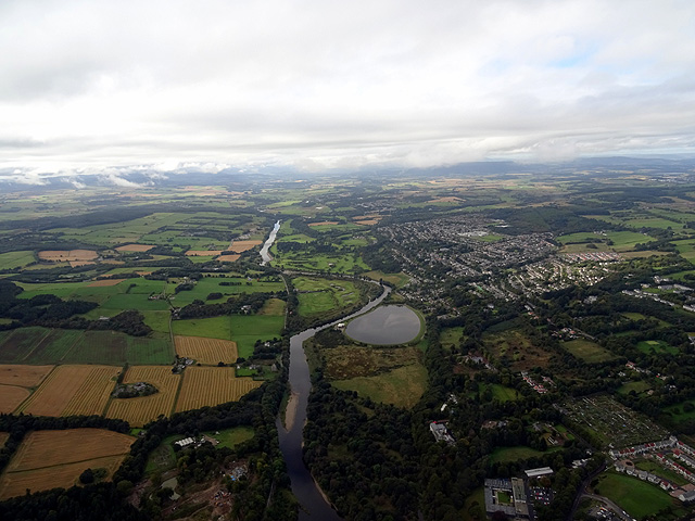
Blairs is a small village located in the historic county of Kincardineshire, Scotland. Situated approximately 7 miles west of Aberdeen, it is nestled amidst picturesque countryside, offering residents and visitors a tranquil and scenic setting.

Blairs is known for its rich history, particularly as the site of Blairs College, a former Catholic seminary. Established in 1829, the college played a significant role in the education and training of Catholic priests in Scotland until its closure in 1986. Today, the college buildings have been converted into a museum and conference center, attracting tourists interested in exploring the region's religious heritage.

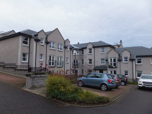
The village itself is characterized by charming stone-built houses and cottages, giving it a traditional and welcoming atmosphere. While Blairs is primarily residential, it benefits from its close proximity to Aberdeen, allowing residents easy access to a wide range of amenities and services.

Nature enthusiasts will appreciate the surrounding countryside, which offers opportunities for scenic walks, hiking, and cycling. The area is home to a diverse range of wildlife, including deer, birds, and small mammals, making it a popular destination for nature lovers.

Blairs also boasts good transport links, with regular bus services connecting the village to Aberdeen and other nearby towns. This makes it convenient for both residents and visitors to explore the wider region and take advantage of the cultural and recreational activities available in Aberdeen.

Overall, Blairs is a charming village with a rich history, offering a peaceful and scenic retreat for those looking to escape the hustle and bustle of city life.

If you have any feedback on the listing, please let us know in the comments section below.

Blairs Images

Images are sourced within 2km of 57.104031/-2.1811149 or Grid Reference NJ8901. Thanks to Geograph Open Source API. All images are credited.

Driveway to Auchlunies
Looking toward the road junction Photographer is standing on the roadway edge near Sunnyside Croft.
Looking toward the road junction
Photographer is standing on the roadway edge near Sunnyside Croft.
Looking southwest from Sunnyside Croft Photographer is standing near the edge of the minor road.
Looking southwest from Sunnyside Croft
Photographer is standing near the edge of the minor road.
Access to Auchlunies House From the road junction north of The Briggs.
Access to Auchlunies House
From the road junction north of The Briggs.
Cowford Cottages By road north from Auchlunies.
Cowford Cottages
By road north from Auchlunies.
Road near to Westerton Looking southward.
Road near to Westerton
Looking southward.
St Devenick's Bieldside
A93, Bieldside
A93, Bieldside
A93, Bieldside
A93, Bieldside
Cult's Kirk Sanctuary
OS Cut Mark - Bieldside, Bieldside Inn <span class="nowrap"><a title="https://www.bench-marks.org.uk/bm84439" rel="nofollow ugc noopener" href="https://www.bench-marks.org.uk/bm84439">Link</a><img style="margin-left:2px;" alt="External link" title="External link - shift click to open in new window" src="https://s1.geograph.org.uk/img/external.png" width="10" height="10"/></span>
OS Cut Mark - Bieldside, Bieldside Inn
Location of OS Cut Mark - Bieldside, Bieldside Inn
St Mary's Chapel The massive, cathedral-like St Mary's Chapel is part of the former Blairs College Roman Catholic seminary. The college complex, incorporating several phases of building and a very large site, closed in the 1980s but the chapel remains open for regular services and for visitors. A small museum and tea room is open throughout the year, and displays some of the College's Catholic art collection, including medieval vestments and the memorial portrait of Mary, Queen of Scots. The college and chapel are built in the former estate lands of John Menzies of Pitfodels who donated the estate to the Catholic Church. The site is in open countryside, close to the banks of the River Dee and set amongst former park land with avenues of trees and straight-edged fields. 

St Mary's Chapel was built as part of a new range for the college, using generous funding by Major Lennon of Liverpool. The chapel is built onto the U-plan range of New College, built from 1898. The chapel itself, to the east of the college, was started in 1899 with Robert Curran as architect.
St Mary's Chapel
The massive, cathedral-like St Mary's Chapel is part of the former Blairs College Roman Catholic seminary. The college complex, incorporating several phases of building and a very large site, closed in the 1980s but the chapel remains open for regular services and for visitors. A small museum and tea room is open throughout the year, and displays some of the College's Catholic art collection, including medieval vestments and the memorial portrait of Mary, Queen of Scots. The college and chapel are built in the former estate lands of John Menzies of Pitfodels who donated the estate to the Catholic Church. The site is in open countryside, close to the banks of the River Dee and set amongst former park land with avenues of trees and straight-edged fields. St Mary's Chapel was built as part of a new range for the college, using generous funding by Major Lennon of Liverpool. The chapel is built onto the U-plan range of New College, built from 1898. The chapel itself, to the east of the college, was started in 1899 with Robert Curran as architect.
Sheltered housing at Manor Place, Cults
Shakkin' Briggie south tower and pier The south tower and pier of the Shakkin' Briggie.  This is the only part of the bridge with the deck still in place.
Shakkin' Briggie south tower and pier
The south tower and pier of the Shakkin' Briggie. This is the only part of the bridge with the deck still in place.
Cattle by Blair In a field by Batchart these highland cattle graze with Bair College behind.
Cattle by Blair
In a field by Batchart these highland cattle graze with Bair College behind.
Inchgarth Reservoir and the River Dee Viewed from a flight from Aberdeen to Birmingham.
Inchgarth Reservoir and the River Dee
Viewed from a flight from Aberdeen to Birmingham.
Supermarket,  Cults
Supermarket, Cults
Show me another place!

Blairs is located at Grid Ref: NJ8901 (Lat: 57.104031, Lng: -2.1811149)

Unitary Authority: Aberdeenshire

Police Authority: North East

What 3 Words

///lazy.souk.hood. Near Cults, Aberdeen

Nearby Locations

Blairs

Related Wikis

Blairs College

St Mary's College, Blairs (commonly known as Blairs College), situated near Aberdeen in Scotland, was from 1829 to 1986 a junior seminary for boys and...

West Cults railway station

West Cults railway station served the small suburban village of West Cults area within the parish of Peterculter from 1894 to 1937 on the Deeside Railway...

Bieldside railway station

Bieldside railway station served the Bieldside area within the parish of Peterculter from 1897 to 1937 on the Deeside Railway that ran from Aberdeen (Joint...
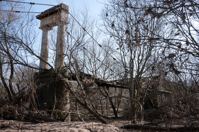
Shakkin' Briggie

St Devenick's Bridge (locally known as the Shakkin' Briggie, or as Morison's Bridge) is a disused suspension footbridge which crosses the River Dee from...

Nearby Amenities

Located within 500m of 57.104031,-2.1811149
Golf: pin
Ref: 7
Lat/Long: 57.1081439/-2.1808504
Golf: pin
Ref: 11
Lat/Long: 57.1082148/-2.1794235
Golf: pin
Ref: 12
Lat/Long: 57.107525/-2.1805579
Golf: pin
Lat/Long: 57.1072554/-2.1828367
Power: pole
Lat/Long: 57.1031569/-2.1730302
Power: pole
Lat/Long: 57.1034449/-2.174751
Power: pole
Lat/Long: 57.1036554/-2.176069
Power: pole
Lat/Long: 57.1036417/-2.1775903
Power: pole
Lat/Long: 57.1036321/-2.178945
Power: pole
Lat/Long: 57.1036129/-2.180316
Power: pole
Lat/Long: 57.1035964/-2.1815078
Power: pole
Lat/Long: 57.1035765/-2.1829534
Power: pole
Lat/Long: 57.1038083/-2.1831591
Power: pole
Lat/Long: 57.1044953/-2.1828069
Power: pole
Lat/Long: 57.1051227/-2.182509
Power: pole
Lat/Long: 57.105698/-2.1817388
Power: pole
Lat/Long: 57.1061793/-2.1811228
Power: pole
Lat/Long: 57.1067408/-2.1804284
Power: pole
Lat/Long: 57.1074388/-2.1794651
Power: pole
Lat/Long: 57.1077514/-2.1790561
Power: pole
Lat/Long: 57.1078001/-2.1789753
Power: pole
Lat/Long: 57.1056322/-2.1809889
Power: pole
Lat/Long: 57.1055513/-2.1799423
Power: pole
Lat/Long: 57.1054758/-2.1789083
Power: pole
Lat/Long: 57.1004689/-2.1846943
Entrance: yes
Lat/Long: 57.1061079/-2.175668
The data included in this document is from www.openstreetmap.org. The data is made available under ODbL.

Have you been to Blairs?

Leave your review of Blairs below (or comments, questions and feedback).