Battersby Junction
Settlement in Yorkshire Hambleton
England
Battersby Junction
![A block of dressed sandstone with holding down bolts Hidden away in the forestry above Bank Foot is a tramway incline that served the sandstones quarries higher on Greenhow Bank. It first appears on the 1893 OS 25 inch map.
Blocks of sandstone would have been lowered down to a siding by the Rosedale Ironstone railway. I guess here a bridge was built to allow the incline to pass carrying an existing track. The line of the incline can be followed quite easily.
The lowest of these quarries is at 230m level. Here the incline branches, one climbs to a quarry at 330m level, the main incline to one at 290m. The 330m quarry was the subject of a post in 2015.
It is tempting to assume that these quarries, which seem to have been used entirely for building stone were operated by the Ingleby Ironstone & Freestone Company which built the original three mile long narrow gauge line to their ironstone mine at Rudd Scar. However, that mine was abandoned in 1860. Their narrow gauge railway had by then been upgraded to standard gauge by the North Yorkshire and Cleveland Railway.
For sources and references see my blog: Out and about ... (2021). Park Plantation Quarry Tramway. [online] Available at: <span class="nowrap"><a title="http://www.fhithich.uk/?p=24999" rel="nofollow ugc noopener" href="http://www.fhithich.uk/?p=24999">Link</a><img style="margin-left:2px;" alt="External link" title="External link - shift click to open in new window" src="https://s1.geograph.org.uk/img/external.png" width="10" height="10"/></span> [Accessed 11 Dec. 2021].
Update 26/12/21
The quarry was operated by the Ingleby Stone Quarry Company, a company probably under the direction of a Mr. Wren. The stone was lowered down to the Rosedale Railway by an incline known as Wren&#039;s Incline see [The Gazette. (1883). Page 6651 | Issue 25299, 25 December 1883 | London ... [online] Available at: <span class="nowrap"><a title="https://www.thegazette.co.uk/London/issue/25299/page/6651/data.htm" rel="nofollow ugc noopener" href="https://www.thegazette.co.uk/London/issue/25299/page/6651/data.htm">Link</a><img style="margin-left:2px;" alt="External link" title="External link - shift click to open in new window" src="https://s1.geograph.org.uk/img/external.png" width="10" height="10"/></span> [Accessed 22 Oct. 2021].].
In 1866, it was reported that a Mr Wren (the same?) had opened an ironstone mine in the area which was &quot;soon afterwards abandoned&quot; [&#039;The Cleveland Ironstone&#039; (1866) Yorkshire Gazette, 25 Aug, 4, available: <span class="nowrap"><a title="https://link-gale-com.ezproxy.is.ed.ac.uk/apps/doc/JF3231098185/GDCS?u=ed_itw&amp;sid=bookmark-GDCS&amp;xid=baf2da3d" rel="nofollow ugc noopener" href="https://link-gale-com.ezproxy.is.ed.ac.uk/apps/doc/JF3231098185/GDCS?u=ed_itw&amp;sid=bookmark-GDCS&amp;xid=baf2da3d">Link</a><img style="margin-left:2px;" alt="External link" title="External link - shift click to open in new window" src="https://s1.geograph.org.uk/img/external.png" width="10" height="10"/></span> [accessed 26 Dec 2021].]. This must be referring to the Ingleby Manor ironstone mine which briefly operated between 1856 and 1860 [Tuffs, Peter. &quot;Catalogue of Cleveland Ironstone Mines&quot;. Page 17. Cleveland Ironstone Series 1996.]. The mine had been developed with high hopes, having expectations of an annual yield of 150,000 tons [&#039;News&#039; (1857) Newcastle Journal, 12 Dec, 8, available: <span class="nowrap"><a title="https://link-gale-com.ezproxy.is.ed.ac.uk/apps/doc/GR3216193104/GDCS?u=ed_itw&amp;sid=bookmark-GDCS&amp;xid=711c2fad" rel="nofollow ugc noopener" href="https://link-gale-com.ezproxy.is.ed.ac.uk/apps/doc/GR3216193104/GDCS?u=ed_itw&amp;sid=bookmark-GDCS&amp;xid=711c2fad">Link</a><img style="margin-left:2px;" alt="External link" title="External link - shift click to open in new window" src="https://s1.geograph.org.uk/img/external.png" width="10" height="10"/></span> [accessed 26 Dec 2021].].](https://s3.geograph.org.uk/geophotos/07/04/11/7041191_d10cbe10.jpg)
Battersby Junction is a small village located in the county of Yorkshire, England. Situated in the North York Moors National Park, it is surrounded by picturesque landscapes and rolling hills, making it an ideal destination for nature enthusiasts and hikers alike.
The village is named after the nearby Battersby railway station, which serves as a significant transportation hub for the area. The station provides regular train services, connecting Battersby Junction to major cities such as Middlesbrough and Whitby.
Despite its small size, Battersby Junction offers a range of amenities to its residents and visitors. The village boasts a cozy local pub, where visitors can enjoy traditional British food and drinks while immersing themselves in the friendly atmosphere. Additionally, there are a few shops and a post office, providing essential services to the local community.
One of the main attractions near Battersby Junction is the North York Moors Railway, a heritage railway that runs steam trains through the stunning moorland scenery. This popular tourist attraction offers visitors the opportunity to step back in time and experience the golden age of steam travel.
The village is also conveniently located near several points of interest. The historic market town of Stokesley is a short drive away, offering a range of shops, cafes, and a weekly market. The coastal town of Saltburn-by-the-Sea, with its sandy beaches and Victorian pier, is also within easy reach.
Overall, Battersby Junction is a charming village that combines the tranquility of rural living with easy access to nearby towns and natural beauty spots, making it a desirable place to visit or call home.
If you have any feedback on the listing, please let us know in the comments section below.
Battersby Junction Images
Images are sourced within 2km of 54.456044/-1.0943345 or Grid Reference NZ5807. Thanks to Geograph Open Source API. All images are credited.


![Footpath towards Drummer Hill Farm The path [number 10.75/1] begins as a lane off the nearby road, but soon does a 90 degree turn to the left to approach Drummer Hill Farm.](https://s0.geograph.org.uk/geophotos/07/05/88/7058844_57e45f86.jpg)


Battersby Junction is located at Grid Ref: NZ5807 (Lat: 54.456044, Lng: -1.0943345)
Division: North Riding
Administrative County: North Yorkshire
District: Hambleton
Police Authority: North Yorkshire
What 3 Words
///fictional.squaring.majors. Near Ingleby Greenhow, North Yorkshire
Nearby Locations
Related Wikis
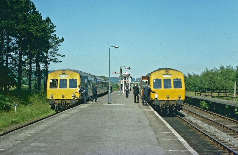
Battersby railway station
Battersby is a railway station on the Esk Valley Line, which runs between Middlesbrough and Whitby via Nunthorpe. The station, situated 11 miles 4 chains...

Battersby
Battersby is a hamlet in North Yorkshire, England. It lies on the edge of the North York Moors National Park and within the historic boundaries of the...

Ingleby railway station
Ingleby railway station was a railway station built to serve the village of Ingleby Greenhow in North Yorkshire, England. The station was on the North...

Ingleby Greenhow
Ingleby Greenhow is a village and civil parish in the Hambleton district of North Yorkshire, England. It is on the border of the North York Moors and 3...
Easby, Hambleton
Easby is a village and civil parish in Hambleton District of North Yorkshire, England. It lies approximately 2 miles (3.2 km) south-east of Great Ayton...

Kildale railway station
Kildale is a railway station on the Esk Valley Line, which runs between Middlesbrough and Whitby via Nunthorpe. The station, situated 12 miles 65 chains...

Easby Moor
Easby Moor is a hill located in the civil parish of Little Ayton in the North York Moors national park within the Cleveland Hills, North Yorkshire, England...
Basedale Priory
Basedale Priory or Baysdale Priory was a priory in North Yorkshire, England located 8 miles (13 km) East from the parish church of Stokesley. It was a...
Related Videos

making hot chocolate whilst hiking. #kidsvideo #kidscamping #camping #rainbows #kidsvideos
My daughter Ava (5) making hot chocolate whilst we were out on a walk.
gribdale loop
trail running.

Roseberry Topping & Captain Cook's Monument | The North York Moors | Miss18Dapper | January 2022
Our stay at Millinder House - The Carthouse. Situated in the North York Moors National Park. Is a beautiful, peaceful place for a ...

Captain cook's Monument virtual walk, 1080p
Join me on my walk around captain cooks monument in the North Yorkshire Moors. let's get outside!
Nearby Amenities
Located within 500m of 54.456044,-1.0943345Have you been to Battersby Junction?
Leave your review of Battersby Junction below (or comments, questions and feedback).