Auchindrean

Settlement in Ross-shire

Scotland

Auchindrean

A distant view of Loch Broom in 1967 From the viewpoint on the A832.
A distant view of Loch Broom in 1967 Credit: John Baker

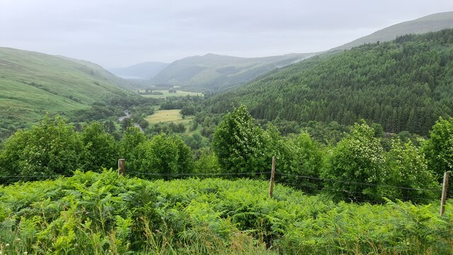
Auchindrean is a small village located in the county of Ross-shire, Scotland. Situated in the picturesque Highlands region, Auchindrean is surrounded by stunning natural landscapes, including rolling hills, lush green fields, and the meandering River Bran. The village is nestled in a valley, offering its residents and visitors breathtaking views of the surrounding countryside.

Although small in size, Auchindrean has a rich history dating back several centuries. It is believed that the village was first settled during the medieval period, and remnants of ancient structures can still be seen today. The village's architecture largely reflects its historical roots, with stone cottages and traditional Scottish houses dotting the landscape.

Despite its rural location, Auchindrean offers a close-knit community atmosphere. The villagers are known for their friendly and welcoming nature, making visitors feel right at home. The village is also home to a few amenities, including a local pub and a convenience store, ensuring that the basic needs of its residents are catered to.

For outdoor enthusiasts, Auchindrean is a haven. The village is surrounded by numerous walking trails and hiking paths, allowing visitors to explore the stunning Highland scenery at their own pace. Fishing is also a popular pastime in the area, with the River Bran offering an abundance of trout and salmon.

Overall, Auchindrean is a peaceful and picturesque village, perfect for those seeking tranquility and an escape from the hustle and bustle of city life. Its natural beauty, rich history, and friendly community make it a hidden gem within the Scottish Highlands.

If you have any feedback on the listing, please let us know in the comments section below.

Auchindrean Images

Images are sourced within 2km of 57.777597/-5.0435951 or Grid Reference NH1980. Thanks to Geograph Open Source API. All images are credited.

A distant view of Loch Broom in 1967 From the viewpoint on the A832.
A distant view of Loch Broom in 1967
From the viewpoint on the A832.
Forestry track near Braemore Square
Forestry track near Braemore Square Meall a' Chrasgaidh is the mountain in the background.
Forestry track near Braemore Square
Meall a' Chrasgaidh is the mountain in the background.
View to Loch Broom
View to Loch Broom
Moorland above Braemore A heavy shower is about to hit but the A832 and A835 roads can just be seen. Corrieshalloch Gorge is between them.
Moorland above Braemore
A heavy shower is about to hit but the A832 and A835 roads can just be seen. Corrieshalloch Gorge is between them.
Footpath  at  Corrieshalloch  Gorge  to  Loch  Broom A sweeping view from a footpath high above the gorge
Footpath at Corrieshalloch Gorge to Loch Broom
A sweeping view from a footpath high above the gorge
View  over  the  Corrieshalloch  Gorge  and  the  A835 The road is going left to right below the trees
View over the Corrieshalloch Gorge and the A835
The road is going left to right below the trees
A  misty  day  in  August Toward Loch Broom
A misty day in August
Toward Loch Broom
Farmstead, Gleann Mor The ruin of a rectangular building.
Farmstead, Gleann Mor
The ruin of a rectangular building.
Buildings at Braemore Square Braemore Square is a complex of buildings in use as holiday accommodation; it's in upper Strath More close to the Corrieshalloch Gorge.
Buildings at Braemore Square
Braemore Square is a complex of buildings in use as holiday accommodation; it's in upper Strath More close to the Corrieshalloch Gorge.
A835 near Braemore
A835 near Braemore
A835 towards Ullapool
Looking northwards from the Corrieshalloch viewpoint All the way to Loch Broom in the far distance
Looking northwards from the Corrieshalloch viewpoint
All the way to Loch Broom in the far distance
Linn Pools, Abhainn Cuileig This river joins Abheinn Droma near the Cuileig Power Station and then they flow down to join Loch Broom
Linn Pools, Abhainn Cuileig
This river joins Abheinn Droma near the Cuileig Power Station and then they flow down to join Loch Broom
Woodland, Braemore Steep slopes below the A835, downstream of  the Corrieshellach Gorge.
Woodland, Braemore
Steep slopes below the A835, downstream of the Corrieshellach Gorge.
River Broom valley Loch Broom in misty distance
River Broom valley
Loch Broom in misty distance
Allt na h-Ighine Looking down the Allt na h-Ighine with An Teallach in the distance.
Allt na h-Ighine
Looking down the Allt na h-Ighine with An Teallach in the distance.
View down Strath More Photo taken from the viewpoint on the A832. The River Broom drains into the distant Loch Broom.
View down Strath More
Photo taken from the viewpoint on the A832. The River Broom drains into the distant Loch Broom.
Show me another place!

Auchindrean is located at Grid Ref: NH1980 (Lat: 57.777597, Lng: -5.0435951)

Unitary Authority: Highland

Police Authority: Highlands and Islands

What 3 Words

///heartless.plugged.dusts. Near Ullapool, Highland

Related Wikis

Auchindrean

Auchindrean (Scottish Gaelic: Achadh an Dreaghainn) is a small settlement close to the southern end of Loch Broom in Wester Ross, in the Highland council...

Corrieshalloch Gorge

Corrieshalloch Gorge (Scottish Gaelic: Coire Shalach, meaning unattractive corrie) is a gorge situated about 20 km south of Ullapool, close to the junction...

Beinn Enaiglair

Beinn Enaiglair (890 m) is a mountain in Wester Ross, Scotland. It lies in the Northwest Highlands. An outlier of the Beinn Dearg range, it is a mountain...

Ross-shire

Ross-shire (; Scottish Gaelic: Siorrachd Rois) is a historic county in the Scottish Highlands. The county borders Sutherland to the north and Inverness...

Inverlael

Inverlael is a hamlet on the southern tip of Loch Broom in Ross-shire in the Highland council area in Scotland. It is located on the A835 main road 6 miles...

Eas Fionn

Eas Fionn is a waterfall of Scotland. == See also == Waterfalls of Scotland == References ==

Beinn Dearg (Ullapool)

Beinn Dearg (one of a number of Scottish hills of that name) is a mountain in the Inverlael area of the Highlands of Scotland. It is most frequently climbed...

Meall a' Chrasgaidh

Meall a' Chrasgaidh is a Scottish mountain located in the Fannich group of mountains, 21 kilometres south-southeast of Ullapool. == Overview == The mountain...

Nearby Amenities

Located within 500m of 57.777597,-5.0435951
Post Box
Operator: Royal Mail
Ref: IV23 199
Source: survey
Lat/Long: 57.7786395/-5.0359154
Parking
Access: yes
Parking: surface
Source: survey
Lat/Long: 57.7786911/-5.0355568
Place: farm
Lat/Long: 57.7777901/-5.0438389
Power: pole
Lat/Long: 57.7735192/-5.043658
Power: pole
Lat/Long: 57.7743974/-5.0439477
Power: pole
Lat/Long: 57.7748322/-5.0440657
Power: pole
Lat/Long: 57.7755273/-5.0442427
Power: pole
Lat/Long: 57.777205/-5.0447041
Power: pole
Lat/Long: 57.7778328/-5.0449669
Power: pole
Lat/Long: 57.7796062/-5.0455543
Power: pole
Lat/Long: 57.778628/-5.0452191
Power: pole
Lat/Long: 57.7804099/-5.0450045
Covered: no
Leisure: picnic_table
Lat/Long: 57.7786449/-5.0354946
Covered: no
Leisure: picnic_table
Lat/Long: 57.778751/-5.0357817
The data included in this document is from www.openstreetmap.org. The data is made available under ODbL.

Have you been to Auchindrean?

Leave your review of Auchindrean below (or comments, questions and feedback).