Allesley Green

Settlement in Warwickshire

England

Allesley Green

St Andrew's Church, Upper Eastern Green
St Andrew's Church, Upper Eastern Green Credit: Ian S

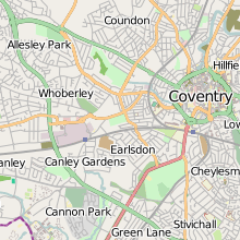
Allesley Green is a small suburban area located in the city of Coventry, in the county of Warwickshire, England. Situated approximately 4 miles northwest of Coventry city centre, Allesley Green is bounded by the areas of Allesley to the north, Mount Nod to the west, and Whoberley to the south.

The area is primarily residential, characterized by a mix of housing types including detached and semi-detached houses. The properties in Allesley Green are predominantly privately owned and cater to a range of budgets. The area is known for its peaceful atmosphere and well-kept green spaces, making it an attractive place to live for families and professionals alike.

Allesley Green benefits from its proximity to various amenities and services. Within walking distance, residents can find a number of local shops, including convenience stores, a post office, and a pharmacy. Additionally, nearby Allesley Park provides a pleasant outdoor space for recreational activities, featuring a large lake, walking paths, and a children's play area.

Transport links in Allesley Green are convenient, with regular bus services connecting the area to Coventry city centre and other nearby suburbs. The area is also well-connected by road, with the A45 and A4114 providing easy access to the wider region.

In summary, Allesley Green is a quiet and pleasant residential area in Warwickshire, offering a range of housing options and benefiting from its proximity to local amenities and transport links.

If you have any feedback on the listing, please let us know in the comments section below.

Allesley Green Images

Images are sourced within 2km of 52.420896/-1.5740566 or Grid Reference SP2980. Thanks to Geograph Open Source API. All images are credited.

St Andrew's Church, Upper Eastern Green
Plaque at St Andrew's Church, Upper Eastern Green
Browns Lane, Allesley, Coventry Browns Lane runs for over a mile along the western edge of Coventry: between-the-wars, 1920s-1930s ribbon development, houses with fields beyond their back gardens on the western side, the gaps gradually filled in later with more modern housing. On the Coventry side, visible on the left in this photo, a 'shadow factory' was built behind the houses in the late 1930s, using equipment and skills from the motor industry, in this case Daimler, to make aircraft parts for the coming war. This was to become the Jaguar Browns Lane car plant, in operation from 1951 to 2005. Since 2008 housing and a business park have been built on the site. <span class="nowrap"><a title="https://en.wikipedia.org/wiki/Browns_Lane_plant" rel="nofollow ugc noopener" href="https://en.wikipedia.org/wiki/Browns_Lane_plant">Link</a><img style="margin-left:2px;" alt="External link" title="External link - shift click to open in new window" src="https://s1.geograph.org.uk/img/external.png" width="10" height="10"/></span>
Browns Lane, Allesley, Coventry
Browns Lane runs for over a mile along the western edge of Coventry: between-the-wars, 1920s-1930s ribbon development, houses with fields beyond their back gardens on the western side, the gaps gradually filled in later with more modern housing. On the Coventry side, visible on the left in this photo, a 'shadow factory' was built behind the houses in the late 1930s, using equipment and skills from the motor industry, in this case Daimler, to make aircraft parts for the coming war. This was to become the Jaguar Browns Lane car plant, in operation from 1951 to 2005. Since 2008 housing and a business park have been built on the site. LinkExternal link
Off to work at BHX4 BHX4 is a 'receive centre' or 'cross dock facility' for Amazon goods. According to the Coventry Telegraph, everything sold by Amazon in the UK passes in and out of this facility, but the goods are not stored here for more than a few hours. Once processed, they are sent on to 'fulfilment centres' elsewhere in the UK 'and even Europe'. It is one of four Amazon sites in the Midlands, all named after the code for Birmingham Airport. The Telegraph reporter claims to have observed a 'fast-paced but good-natured atmosphere' in the building, which has three floors, each the size of eight football pitches. <span class="nowrap"><a title="https://www.coventrytelegraph.net/news/coventry-news/coventry-news-amazon-coventry-warehouse-15580127" rel="nofollow ugc noopener" href="https://www.coventrytelegraph.net/news/coventry-news/coventry-news-amazon-coventry-warehouse-15580127">Link</a><img style="margin-left:2px;" alt="External link" title="External link - shift click to open in new window" src="https://s1.geograph.org.uk/img/external.png" width="10" height="10"/></span> 

The receive centre is built on part of the site of the Jaguar Browns Lane plant, which made Jaguar cars between 1951 and 2005. This change of use is emblematic of the shift of employment in Coventry away from manufacturing to distribution and services.
Off to work at BHX4
BHX4 is a 'receive centre' or 'cross dock facility' for Amazon goods. According to the Coventry Telegraph, everything sold by Amazon in the UK passes in and out of this facility, but the goods are not stored here for more than a few hours. Once processed, they are sent on to 'fulfilment centres' elsewhere in the UK 'and even Europe'. It is one of four Amazon sites in the Midlands, all named after the code for Birmingham Airport. The Telegraph reporter claims to have observed a 'fast-paced but good-natured atmosphere' in the building, which has three floors, each the size of eight football pitches. LinkExternal link The receive centre is built on part of the site of the Jaguar Browns Lane plant, which made Jaguar cars between 1951 and 2005. This change of use is emblematic of the shift of employment in Coventry away from manufacturing to distribution and services.
Worsfold Close, Allesley
The Windmill Hill, Allesley
Brown's Lane, Allesley
Birmingham Road at the junction of Allesley Croft
Rye Hill, Allesley
Rye Hill, Allesley
St Andrew's Church, Eastern Green This parish church of the Church of England stands on the western edge of Coventry, surrounded by fields. A red brick building in the Gothic revival style, it opened in 1875, according to the parish website, which doesn't mention the name of the architect <span class="nowrap"><a title="https://standrewseg.co.uk/information/history-of-st-andrews-church/" rel="nofollow ugc noopener" href="https://standrewseg.co.uk/information/history-of-st-andrews-church/">Link</a><img style="margin-left:2px;" alt="External link" title="External link - shift click to open in new window" src="https://s1.geograph.org.uk/img/external.png" width="10" height="10"/></span> . 

Two Giant Sequoia (Sequoiadendron giganteum) trees, otherwise known as Giant Redwood or Wellingtonia, were planted in the churchyard, on either side of the path from gate to church. One has been felled and only a huge stump remains. The other now towers over the church, and can be seen to the left of the steeple.
St Andrew's Church, Eastern Green
This parish church of the Church of England stands on the western edge of Coventry, surrounded by fields. A red brick building in the Gothic revival style, it opened in 1875, according to the parish website, which doesn't mention the name of the architect LinkExternal link . Two Giant Sequoia (Sequoiadendron giganteum) trees, otherwise known as Giant Redwood or Wellingtonia, were planted in the churchyard, on either side of the path from gate to church. One has been felled and only a huge stump remains. The other now towers over the church, and can be seen to the left of the steeple.
Gate, St Andrew's Church, Eastern Green Upper Eastern Green Lane can be seen through the churchyard gates and their decorative lamp overthrow. For more on the church itself see <a href="https://www.geograph.org.uk/photo/7524219">SP2780 : St Andrew's Church, Eastern Green</a>.
Gate, St Andrew's Church, Eastern Green
Upper Eastern Green Lane can be seen through the churchyard gates and their decorative lamp overthrow. For more on the church itself see SP2780 : St Andrew's Church, Eastern Green.
Oak tree and fencing, Pickford The fencing indicates that this still-rural part of western Coventry, to the south of the A45, is soon to be built up with housing.
Oak tree and fencing, Pickford
The fencing indicates that this still-rural part of western Coventry, to the south of the A45, is soon to be built up with housing.
Oak tree by building site fence, Pickford The fence indicates that these fields on the western edge of Coventry, south of the A45, are soon to be built up with housing. I hope the mature trees will survive the earth moving and will be incorporated into the new development. Having misread the map I was on the wrong side of the hedge; the public footpath runs along the other side, off to the right of the photo.
Oak tree by building site fence, Pickford
The fence indicates that these fields on the western edge of Coventry, south of the A45, are soon to be built up with housing. I hope the mature trees will survive the earth moving and will be incorporated into the new development. Having misread the map I was on the wrong side of the hedge; the public footpath runs along the other side, off to the right of the photo.
Footpath alongside Windmill Village Golf Club, Allesley The footpath runs down the slope from the A45 dual carriageway to a footbridge over the Pickford Brook, where it forks, with paths continuing to Lower and to Upper Eastern Green. The footpath marker has been overgrown by the hedge surrounding the golf course, but a Henry Moore hole has been cut in the hedge to reveal it. The A45 is a formidable barrier to pedestrians here and is too dangerous to cross on foot.
Footpath alongside Windmill Village Golf Club, Allesley
The footpath runs down the slope from the A45 dual carriageway to a footbridge over the Pickford Brook, where it forks, with paths continuing to Lower and to Upper Eastern Green. The footpath marker has been overgrown by the hedge surrounding the golf course, but a Henry Moore hole has been cut in the hedge to reveal it. The A45 is a formidable barrier to pedestrians here and is too dangerous to cross on foot.
Barn at Windmill Village Hotel, Allesley This barn once formed part of Windmill Farm and now belongs to the Windmill Village golf hotel complex. It has been converted sensitively, on the outside at least; whatever it may be used for now, its frontage facing the busy A45 Birmingham Road still displays the plain lines of a traditional barn, with its high double doors.
Barn at Windmill Village Hotel, Allesley
This barn once formed part of Windmill Farm and now belongs to the Windmill Village golf hotel complex. It has been converted sensitively, on the outside at least; whatever it may be used for now, its frontage facing the busy A45 Birmingham Road still displays the plain lines of a traditional barn, with its high double doors.
HPL Building, Allesley This factory with a fine art deco frontage greets travellers approaching Coventry along the A45 from Birmingham. It dates from the late 1930s, according to the Heritage Gateway site <span class="nowrap"><a title="https://www.heritagegateway.org.uk/Gateway/Results_Single.aspx?uid=MCT6355&resourceID=1029" rel="nofollow ugc noopener" href="https://www.heritagegateway.org.uk/Gateway/Results_Single.aspx?uid=MCT6355&resourceID=1029">Link</a><img style="margin-left:2px;" alt="External link" title="External link - shift click to open in new window" src="https://s1.geograph.org.uk/img/external.png" width="10" height="10"/></span> and is locally listed; see the Coventry City Council site <span class="nowrap"><a title="https://www.coventry.gov.uk/downloads/file/17245/local_list_of_buildings_of_architectural_or_historic_interest.pdf" rel="nofollow ugc noopener" href="https://www.coventry.gov.uk/downloads/file/17245/local_list_of_buildings_of_architectural_or_historic_interest.pdf">Link</a><img style="margin-left:2px;" alt="External link" title="External link - shift click to open in new window" src="https://s1.geograph.org.uk/img/external.png" width="10" height="10"/></span> . It was built for Triumph, the motorcycle manufacturers, for their service division, and was known as the 'Model Garage', according to Dave Gleed, who worked there and is quoted by Our Warwickshire <span class="nowrap"><a title="https://www.ourwarwickshire.org.uk/content/article/old-standard-triumph-buildings" rel="nofollow ugc noopener" href="https://www.ourwarwickshire.org.uk/content/article/old-standard-triumph-buildings">Link</a><img style="margin-left:2px;" alt="External link" title="External link - shift click to open in new window" src="https://s1.geograph.org.uk/img/external.png" width="10" height="10"/></span> :  "I loved my job, working with a great bunch of lads. It was like being in the army again, a band of brothers. I mean, you spend more time with them than with your wives."

On reflection, I think the style is more art moderne than art deco, like the Tollgate pub not far away on Holyhead Road in Allesley - a sleek, streamlined style for the new motor roads of the 1930s. The strong horizontal lines, curved corners and glass bricks all suggest art moderne; see the Architectural Styles blog <span class="nowrap"><a title="https://architecturestyles.org/art-deco/" rel="nofollow ugc noopener" href="https://architecturestyles.org/art-deco/">Link</a><img style="margin-left:2px;" alt="External link" title="External link - shift click to open in new window" src="https://s1.geograph.org.uk/img/external.png" width="10" height="10"/></span> .
HPL Building, Allesley
This factory with a fine art deco frontage greets travellers approaching Coventry along the A45 from Birmingham. It dates from the late 1930s, according to the Heritage Gateway site LinkExternal link and is locally listed; see the Coventry City Council site LinkExternal link . It was built for Triumph, the motorcycle manufacturers, for their service division, and was known as the 'Model Garage', according to Dave Gleed, who worked there and is quoted by Our Warwickshire LinkExternal link : "I loved my job, working with a great bunch of lads. It was like being in the army again, a band of brothers. I mean, you spend more time with them than with your wives." On reflection, I think the style is more art moderne than art deco, like the Tollgate pub not far away on Holyhead Road in Allesley - a sleek, streamlined style for the new motor roads of the 1930s. The strong horizontal lines, curved corners and glass bricks all suggest art moderne; see the Architectural Styles blog LinkExternal link .
Flats, Birmingham Road, Allesley These council flats in Allesley resemble the ones built around 1950 by the Coventry Corporation City Architect's department under Donald Gibson in the Stonebridge estate on the south side of the city; see <a href="https://www.geograph.org.uk/photo/7588116">SP3375 : Flats, Gregory Hood Road, Coventry</a>. The layout is similar, too; some, like these, face onto a green and the main road, others are laid out in monotonous parallel lines, as at Stonebridge.
Flats, Birmingham Road, Allesley
These council flats in Allesley resemble the ones built around 1950 by the Coventry Corporation City Architect's department under Donald Gibson in the Stonebridge estate on the south side of the city; see SP3375 : Flats, Gregory Hood Road, Coventry. The layout is similar, too; some, like these, face onto a green and the main road, others are laid out in monotonous parallel lines, as at Stonebridge.
Show me another place!

Allesley Green is located at Grid Ref: SP2980 (Lat: 52.420896, Lng: -1.5740566)

Unitary Authority: Coventry

Police Authority: West Midlands

What 3 Words

///navy.divide.bought. Near Keresley, West Midlands

Nearby Locations

Allesley Green

Related Wikis

Allesley Green

Allesley Green is a modern suburb of Coventry in the West Midlands, England, within the civil parish of Allesley. The suburb lies west of the A45 road...

Allesley Castle

Allesley Castle is a former motte and bailey castle in Allesley, Coventry. The mound has never been excavated. All that remains of the castle is a large...

Allesley Park

Allesley Park is a park near Coventry, West Midlands, England. It is also the name of the residential suburb adjacent to the park, which is approximately...

Stone House, Allesley

Stone House is a 16th-century sandstone farmhouse next to Birmingham Road in Allesley, Coventry. It is Grade II* listed for a number of architectural features...

Eastern Green

Eastern Green is a mainly residential suburb in the far west of Coventry, England, and was formerly a village in Warwickshire. Its most western area is...

Trinity House, Allesley

Trinity House was a small country house in the village of Allesley, Coventry in the West Midlands, formerly the county of Warwickshire. It stood at the...

Coventry North West (UK Parliament constituency)

Coventry North West is a constituency in the city of Coventry represented in the House of Commons of the UK Parliament since 2019 by Taiwo Owatemi of the...

Woodlands Academy, Coventry

Woodlands Academy (formerly The Woodlands School and Sports College) was a boys secondary school situated in west Coventry in the West Midlands, England...

Nearby Amenities

Located within 500m of 52.420896,-1.5740566
Motorway Junction
Lat/Long: 52.4182068/-1.5691994
Traffic Signals
Traffic Signals: signal
Lat/Long: 52.4219567/-1.5689675
Mini Roundabout
Direction: clockwise
Source: Bing
Lat/Long: 52.4209326/-1.5740374
Crossing
Button Operated: yes
Crossing: traffic_signals
Crossing Island: no
Crossing Ref: toucan
Tactile Paving: yes
Lat/Long: 52.4211622/-1.5695243
Crossing
Button Operated: yes
Crossing: traffic_signals
Crossing Island: no
Crossing Ref: toucan
Tactile Paving: yes
Lat/Long: 52.421522/-1.5706539
Fuel
Gulf
Brand: Gulf
Brand Wikidata: Q5617505
Brand Wikipedia: en:Gulf Oil LP
Fhrs Id: 240834
Source: gps drive-by
Lat/Long: 52.425104/-1.5719194
Bus Stop
Parkhill Dr / Parkhill Estate Terminus
NaPTANAreaCode: 43000073901
Bench: yes
Bin: yes
Bus: yes
Naptan AtcoCode: 43000073901
Naptan Bearing: E
Naptan BusStopType: MKD
Naptan CommonName: Parkhill Estate Terminus
Naptan Indicator: adj
Naptan NaptanCode: nwmadatj
Naptan PlusbusZoneRef: BHAMNWS
Naptan Status: ACT
Naptan StopType: BCT
Naptan Street: PARKHILL DR
Naptan Towards: Both directions
Naptan Verified: no
Public Transport: platform
Route Ref: X1
Shelter: yes
Shelter Ref: 711429
Source: WMCA
Tactile Paving: no
Lat/Long: 52.4211037/-1.5737365
Bus Stop
Sutherland Ave / Aberdeen Close
Bus: yes
Naptan AtcoCode: 43000177601
Naptan Bearing: W
Naptan BusStopType: MKD
Naptan CommonName: Aberdeen Close
Naptan Indicator: opp
Naptan NaptanCode: nwmdpdwa
Naptan PlusbusZoneRef: BHAMNWS
Naptan Status: ACT
Naptan StopType: BCT
Naptan Street: SUTHERLAND AVE
Naptan Verified: no
Note: infrastructure now removed?
Public Transport: platform
Source: WMCA
Lat/Long: 52.417403/-1.5715516
Crossing
Crossing: unmarked
Crossing Island: no
Tactile Paving: yes
Lat/Long: 52.4216805/-1.5710765
Traffic Signals
Traffic Signals: crossing
Lat/Long: 52.4227411/-1.5710931
Crossing
Button Operated: yes
Crossing: traffic_signals
Crossing Island: no
Crossing Ref: toucan
Tactile Paving: yes
Lat/Long: 52.4227671/-1.5700411
Crossing
Crossing: unmarked
Crossing Island: no
Crossing Markings: no
Tactile Paving: yes
Lat/Long: 52.4228986/-1.5688793
Traffic Signals
Traffic Signals: signal
Lat/Long: 52.4215431/-1.5704656
Crossing
Crossing: unmarked
Crossing Island: no
Tactile Paving: yes
Lat/Long: 52.4217966/-1.5711329
Kerb: raised
Lat/Long: 52.4217523/-1.5752772
Barrier: kissing_gate
Lat/Long: 52.4224171/-1.5808534
Allesley Green
Is In: Coventry
Place: neighbourhood
Source: NPLG
Wikidata: Q4732173
Wikipedia: en:Allesley Green
Lat/Long: 52.4213425/-1.5740372
Parkhill Dr / Appledore Drive
Naptan AtcoCode: 43000009901
Naptan Bearing: S
Naptan BusStopType: CUS
Naptan CommonName: Appledore Drive
Naptan NaptanCode: nwmptdgm
Naptan Status: ACT
Naptan StopType: BCT
Naptan Street: PARKHILL DR
Source: WMCA
Lat/Long: 52.417067/-1.576343
Bus Stop
Sutherland Ave / Aberdeen Close
Bus: yes
Naptan AtcoCode: 43000177602
Naptan Bearing: E
Naptan BusStopType: MKD
Naptan CommonName: Aberdeen Close
Naptan Indicator: adj
Naptan NaptanCode: nwmwatpm
Naptan Status: ACT
Naptan StopType: BCT
Naptan Street: SUTHERLAND AVE
Public Transport: platform
Source: WMCA
Lat/Long: 52.4174836/-1.5715861
Post Box
Brand: Royal Mail
Brand Wikidata: Q638098
Brand Wikipedia: en:Royal Mail
Collection Times: Mo-Fr 09:00, Sa 07:00
Operator: Royal Mail
Operator Wikidata: Q638098
Post Box Type: pillar
Ref: CV5 456D
Royal Cypher: EIIR
Royal Cypher Wikidata: Q33102113
Source: survey
Lat/Long: 52.4210374/-1.5725528
Generator Method: photovoltaic
Generator Output Electricity: yes
Generator Source: solar
Generator Type: solar_photovoltaic_panel
Location: roof
Power: generator
Lat/Long: 52.4175681/-1.5762484
Generator Method: photovoltaic
Generator Output Electricity: yes
Generator Source: solar
Generator Type: solar_photovoltaic_panel
Location: roof
Power: generator
Lat/Long: 52.4199041/-1.575771
Generator Method: photovoltaic
Generator Output Electricity: yes
Generator Source: solar
Generator Type: solar_photovoltaic_panel
Location: roof
Power: generator
Lat/Long: 52.4191435/-1.5754196
Generator Method: photovoltaic
Generator Output Electricity: yes
Generator Source: solar
Generator Type: solar_photovoltaic_panel
Location: roof
Power: generator
Lat/Long: 52.4180295/-1.575653
Generator Method: photovoltaic
Generator Output Electricity: yes
Generator Source: solar
Generator Type: solar_photovoltaic_panel
Location: roof
Power: generator
Lat/Long: 52.4182912/-1.5753552
Generator Method: photovoltaic
Generator Output Electricity: yes
Generator Source: solar
Generator Type: solar_photovoltaic_panel
Location: roof
Power: generator
Lat/Long: 52.4187312/-1.5724021
Generator Method: photovoltaic
Generator Output Electricity: yes
Generator Source: solar
Generator Type: solar_photovoltaic_panel
Location: roof
Power: generator
Lat/Long: 52.421095/-1.5755886
Generator Method: photovoltaic
Generator Output Electricity: yes
Generator Source: solar
Generator Type: solar_photovoltaic_panel
Location: roof
Power: generator
Lat/Long: 52.4203818/-1.5782949
Generator Method: photovoltaic
Generator Output Electricity: yes
Generator Source: solar
Generator Type: solar_photovoltaic_panel
Location: roof
Power: generator
Lat/Long: 52.4198959/-1.5775761
Generator Method: photovoltaic
Generator Output Electricity: yes
Generator Source: solar
Generator Type: solar_photovoltaic_panel
Location: roof
Power: generator
Lat/Long: 52.417699/-1.5767714
Generator Method: photovoltaic
Generator Output Electricity: yes
Generator Source: solar
Generator Type: solar_photovoltaic_panel
Location: roof
Power: generator
Lat/Long: 52.4243247/-1.5746711
Generator Method: photovoltaic
Generator Output Electricity: yes
Generator Source: solar
Generator Type: solar_photovoltaic_panel
Location: roof
Power: generator
Lat/Long: 52.4207032/-1.5712325
Generator Method: photovoltaic
Generator Output Electricity: yes
Generator Source: solar
Generator Type: solar_photovoltaic_panel
Location: roof
Power: generator
Lat/Long: 52.4189562/-1.5725039
Generator Method: photovoltaic
Generator Output Electricity: yes
Generator Source: solar
Generator Type: solar_photovoltaic_panel
Location: roof
Power: generator
Lat/Long: 52.4183779/-1.5680154
Traffic Signals
Traffic Signals: signal
Lat/Long: 52.4214896/-1.5706373
Traffic Signals
Traffic Signals: signal
Lat/Long: 52.4227945/-1.570072
Traffic Signals
Traffic Signals: signal
Lat/Long: 52.4226571/-1.5700611
Traffic Signals
Traffic Signals: signal
Lat/Long: 52.4220191/-1.5691241
Crossing
Button Operated: yes
Crossing: traffic_signals
Crossing Island: no
Crossing Ref: toucan
Tactile Paving: yes
Lat/Long: 52.4228068/-1.5711185
Traffic Signals
Traffic Signals: crossing
Lat/Long: 52.4212092/-1.5695288
The data included in this document is from www.openstreetmap.org. The data is made available under ODbL.

Have you been to Allesley Green?

Leave your review of Allesley Green below (or comments, questions and feedback).