An Àird

Settlement in Inverness-shire

Scotland

An Àird

South Skye skyline Looking along the cost towards Aird.
South Skye skyline Credit: Mark Percy

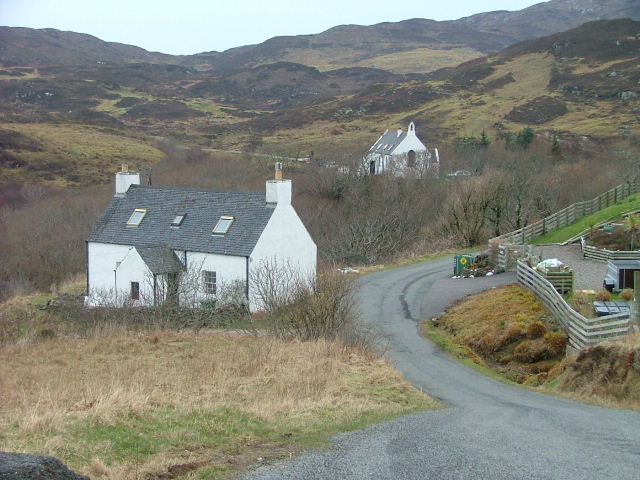
An Àird is a small rural settlement located in Inverness-shire, a county in the Scottish Highlands. Situated amidst stunning natural landscapes, An Àird is nestled near the western shore of Loch Ness, one of Scotland's most iconic and mysterious bodies of water.

The village itself is characterized by its picturesque charm, with traditional stone houses and scenic views of the surrounding hills and forests. The tranquil atmosphere and unspoiled beauty of An Àird make it a popular destination for nature enthusiasts and those seeking a peaceful retreat.

An Àird's proximity to Loch Ness offers visitors the opportunity to explore the famous loch and its legendary monster, Nessie. Many tourists flock to the area to take boat trips, hoping to catch a glimpse of the elusive creature. The village also serves as a gateway to the wider Highlands region, with numerous hiking trails and outdoor activities available nearby.

Although small in size, An Àird boasts a strong sense of community. Local amenities include a village hall, a primary school, and a few small businesses that cater to both residents and visitors. The village is known for its warm hospitality and friendly locals, making it a welcoming place to visit.

Overall, An Àird is a charming and idyllic rural settlement in Inverness-shire, offering a peaceful escape for nature lovers and those looking to immerse themselves in the Scottish Highlands' beauty and folklore.

If you have any feedback on the listing, please let us know in the comments section below.

An Àird Images

Images are sourced within 2km of 57.034068/-5.9708536 or Grid Reference NG5900. Thanks to Geograph Open Source API. All images are credited.

South Skye skyline Looking along the cost towards Aird.
South Skye skyline
Looking along the cost towards Aird.
Track to the Point of Sleat
White Sail Over the sea to Skye (Sound of Sleat)
White Sail
Over the sea to Skye (Sound of Sleat)
Rough grazings west of An Aìrd Both black cattle and sheep are grazed here on the hill to the west of the settlement at the south end of Sleat. The houses of An Aìrd are scattered in the distance, with a view beyond to the mainland.
Rough grazings west of An Aìrd
Both black cattle and sheep are grazed here on the hill to the west of the settlement at the south end of Sleat. The houses of An Aìrd are scattered in the distance, with a view beyond to the mainland.
Telephone box, Aird of Sleat
Ard Thurinish Rocky headland east of the Point of Sleat. Scattered houses of An Aird beyond.
Ard Thurinish
Rocky headland east of the Point of Sleat. Scattered houses of An Aird beyond.
Portion of Shoreline A portion of shoreline in this square, large boulders, much rubbish washed-up.
Dog in picture is Floss
Portion of Shoreline
A portion of shoreline in this square, large boulders, much rubbish washed-up. Dog in picture is Floss
Àrd Thurinish Àrd Thurinish (wheat point) lies south of the settlement of An Àird at the south end of Sleat. It juts into one of only five grid-squares on Skye that are not in the NG myriad.
The island on the horizon is Eigg.
Àrd Thurinish
Àrd Thurinish (wheat point) lies south of the settlement of An Àird at the south end of Sleat. It juts into one of only five grid-squares on Skye that are not in the NG myriad. The island on the horizon is Eigg.
Approaching Aird of Sleat The walk on to Point of Sleat was tempting, but time did not permit. The distant hills on the left will be on the Isle of Rum.
Approaching Aird of Sleat
The walk on to Point of Sleat was tempting, but time did not permit. The distant hills on the left will be on the Isle of Rum.
Grazings, An Àird View northwards towards more boggy land. I was being followed by a flock of hungry sheep. There are unfriendly notices at the road end which as well spouting nonsense about "no unauthorised cycles", warned about not approaching stock!  Sheep are meant to run away!
Grazings, An Àird
View northwards towards more boggy land. I was being followed by a flock of hungry sheep. There are unfriendly notices at the road end which as well spouting nonsense about "no unauthorised cycles", warned about not approaching stock! Sheep are meant to run away!
Moorland, An Àird Heather and bog at the southern end of Sleat. It is grazed by cattle in Summer.
Moorland, An Àird
Heather and bog at the southern end of Sleat. It is grazed by cattle in Summer.
Loch Fada A Lochan near Sgùrr nan Caorach on the moorland above An Àird.
Loch Fada
A Lochan near Sgùrr nan Caorach on the moorland above An Àird.
An unfinished fence Fence wire lies beside a shallow lochan in the latter stages of transition to bog.
An unfinished fence
Fence wire lies beside a shallow lochan in the latter stages of transition to bog.
Fence, An Àird A barbed wire fence, fortunately with a hole in it, above Aird of Sleat.
Fence, An Àird
A barbed wire fence, fortunately with a hole in it, above Aird of Sleat.
Bog, An Àird Very wet ground just beyond the limits of the improved grazing land.
Bog, An Àird
Very wet ground just beyond the limits of the improved grazing land.
An Àird The township at the southern tip of Skye, a view from higher ground taken when returning from the hill.
An Àird
The township at the southern tip of Skye, a view from higher ground taken when returning from the hill.
Road end, An Àird The start of an unsealed road to Point of Sleat. There really ought not to be any anti-cycling signs, even before 2005, and it is totally unacceptable now. Of course it is not an inaccurate sign; it says "no unauthorised" vehicles - bikes of course are authorised.  Perhaps they missed out "motor"? One can hope.
Road end, An Àird
The start of an unsealed road to Point of Sleat. There really ought not to be any anti-cycling signs, even before 2005, and it is totally unacceptable now. Of course it is not an inaccurate sign; it says "no unauthorised" vehicles - bikes of course are authorised. Perhaps they missed out "motor"? One can hope.
Show me another place!

An Àird is located at Grid Ref: NG5900 (Lat: 57.034068, Lng: -5.9708536)

Unitary Authority: Highland

Police Authority: Highlands and Islands

Also known as: Aird

What 3 Words

///crunches.giggles.cringe. Near Armadale, Highland

Related Wikis

Aird of Sleat

Aird of Sleat (Scottish Gaelic: Àird Shlèite) is a village on the Isle of Skye in Scotland. It is at the southern end of the Sleat peninsula, 4 miles...

Ardvasar

Ardvasar (Scottish Gaelic: Àird a’ Bhàsair) is a village near the southern end of the Sleat peninsula, on the Isle of Skye in Scotland. It is just to the...

Armadale, Skye

Armadale (Scottish Gaelic: Armadal) is a village near the southern end of the Sleat peninsula on the Isle of Skye, in the Highland council area of Scotland...
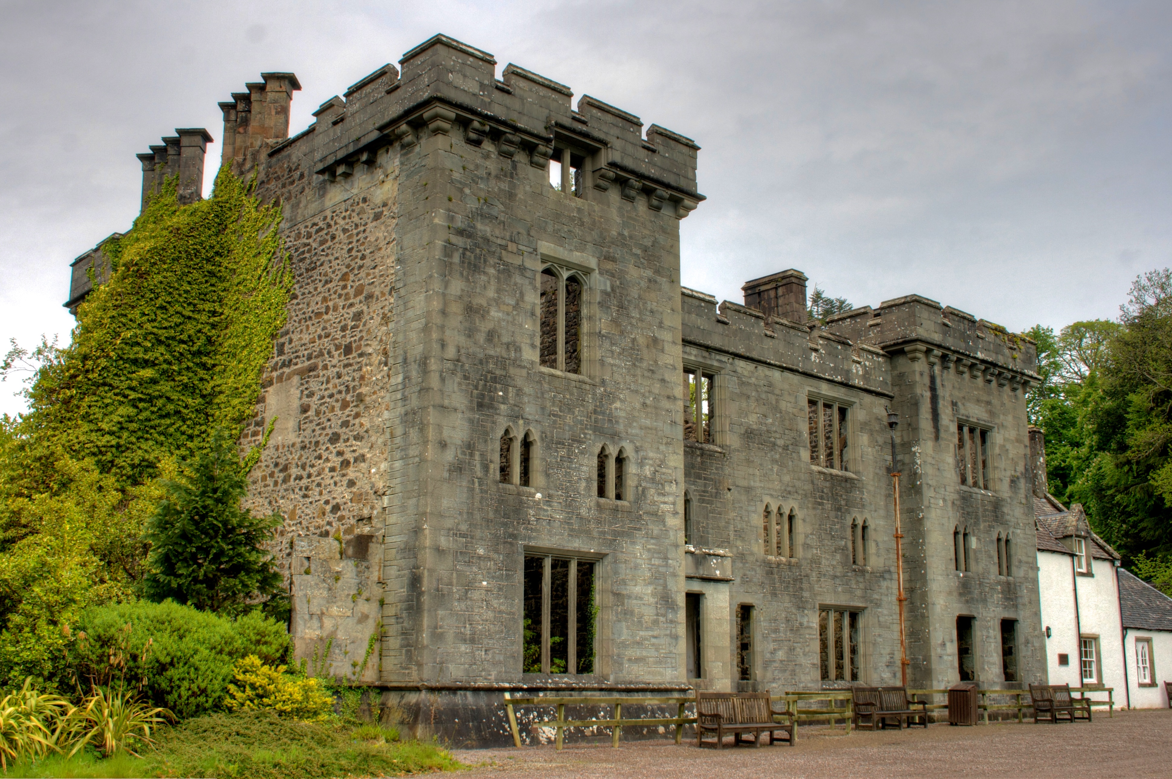
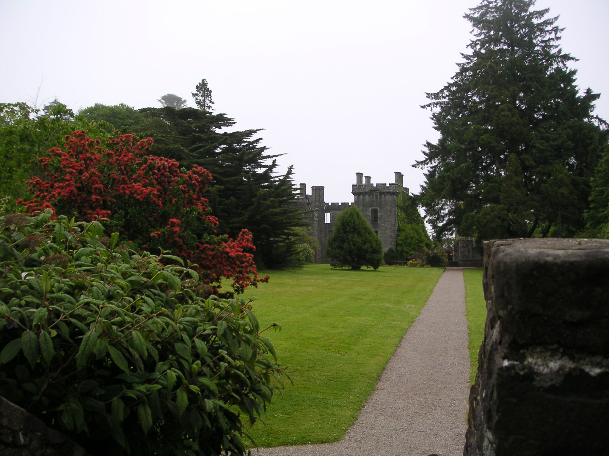
Armadale Castle

Armadale Castle is a ruined country house in Armadale, Skye, former home of the MacDonalds. A mansion house was first built here around 1790, facing south...

Nearby Amenities

Located within 500m of 57.034068,-5.9708536
Passing Place
Lat/Long: 57.033539/-5.9685662
Passing Place
Lat/Long: 57.0331496/-5.9663378
Telephone
Booth: K6
Covered: booth
Phone: +44 1471 844237
Source: survey
Lat/Long: 57.0330683/-5.9662104
Post Box
Post Box Type: lamp
Ref: IV44 108
Source: survey
Lat/Long: 57.0332254/-5.9680429
Aird
Alt Name: Aird of Sleat
Alt Name Gd: Àird Shlèite
Name Be: Эйрд
Name En: Aird
Name Gd: An Àird
Name Ru: Эйрд
Name Uk: Ейрд
Place: village
Source: local_knowledge
Wikidata: Q2228036
Wikipedia: en:Aird of Sleat
Lat/Long: 57.0329741/-5.9669371
An Stac
Place: locality
Lat/Long: 57.0319798/-5.9753457
Port na Long
Natural: bay
Lat/Long: 57.0298636/-5.9700222
Power: pole
Lat/Long: 57.0319435/-5.9640084
Power: pole
Lat/Long: 57.0319055/-5.9645395
Power: pole
Lat/Long: 57.0318588/-5.9653294
Power: pole
Lat/Long: 57.0342298/-5.9718324
Power: pole
Lat/Long: 57.0361559/-5.973077
Power: pole
Lat/Long: 57.0359184/-5.973368
Power: pole
Lat/Long: 57.0353799/-5.9728745
Power: pole
Lat/Long: 57.03498/-5.9725164
Power: pole
Lat/Long: 57.0345677/-5.9721436
Power: pole
Lat/Long: 57.0325168/-5.9711205
Power: pole
Lat/Long: 57.0328541/-5.9716852
Power: pole
Lat/Long: 57.0331647/-5.9722226
Power: pole
Lat/Long: 57.0334506/-5.9727047
Power: pole
Lat/Long: 57.0334467/-5.9722327
Power: pole
Lat/Long: 57.0341642/-5.9654288
Power: pole
Lat/Long: 57.0341729/-5.9666084
Power: pole
Lat/Long: 57.0341992/-5.9683275
Power: pole
Lat/Long: 57.0342321/-5.9702117
Power: pole
Lat/Long: 57.0345475/-5.9643439
Power: pole
Lat/Long: 57.0349331/-5.9632971
Power: pole
Lat/Long: 57.0346965/-5.962667
Power: pole
Lat/Long: 57.0346133/-5.9632146
Power: pole
Lat/Long: 57.0345355/-5.9637541
Power: pole
Lat/Long: 57.0345092/-5.9642895
Power: pole
Lat/Long: 57.0325524/-5.9653212
Power: pole
Lat/Long: 57.0330179/-5.9653091
Power: pole
Lat/Long: 57.0333136/-5.965291
Power: pole
Lat/Long: 57.0337496/-5.9652628
The data included in this document is from www.openstreetmap.org. The data is made available under ODbL.

Have you been to An Àird?

Leave your review of An Àird below (or comments, questions and feedback).