Achnamara

Settlement in Argyllshire

Scotland

Achnamara

The Lily Loch This loch is known locally as the Lily Loch, although it has no name on the map. Waterlilies can be seen growing in the shallow margins of the loch. Bog myrtle fringes the loch in front of the photographer.
The Lily Loch Credit: Patrick Mackie

Achnamara is a small village located in the region of Argyllshire in western Scotland. Situated within the larger administrative area of Argyll and Bute, Achnamara is nestled amidst the stunning natural beauty of the Scottish countryside. The village is situated about 10 miles south of Lochgilphead, the main town in the surrounding area.

Achnamara enjoys a peaceful and idyllic setting, surrounded by rolling hills, lush green fields, and breathtaking views of the nearby Loch Sween. The village is known for its tranquil atmosphere and close-knit community, making it an ideal destination for those seeking a quiet retreat or a base for exploring the beautiful Scottish Highlands.

The village itself is small, consisting of a handful of residential properties, a local church, and a primary school. While there are no major amenities or services within Achnamara, the nearby town of Lochgilphead offers a range of shops, supermarkets, restaurants, and leisure facilities.

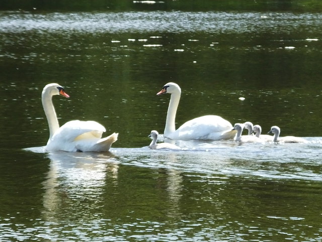
For outdoor enthusiasts, Achnamara serves as an excellent starting point for exploring the surrounding countryside. The area is renowned for its stunning landscapes, offering opportunities for hiking, cycling, fishing, and wildlife spotting. Loch Sween, in particular, is a popular spot for boating and sailing enthusiasts, with its calm waters and picturesque shores.

Overall, Achnamara is a charming and picturesque village, offering a peaceful and scenic retreat for visitors seeking to explore the natural wonders of western Scotland.

If you have any feedback on the listing, please let us know in the comments section below.

Achnamara Images

Images are sourced within 2km of 56.02544/-5.5660199 or Grid Reference NR7787. Thanks to Geograph Open Source API. All images are credited.

The Lily Loch This loch is known locally as the Lily Loch, although it has no name on the map. Waterlilies can be seen growing in the shallow margins of the loch. Bog myrtle fringes the loch in front of the photographer.
The Lily Loch
This loch is known locally as the Lily Loch, although it has no name on the map. Waterlilies can be seen growing in the shallow margins of the loch. Bog myrtle fringes the loch in front of the photographer.
Beaver lodge on Lochan Buic This lodge is partially constructed as tunnels in soft ground on the edge of the loch.
See also <a href="https://www.geograph.org.uk/photo/3038287">NR7888 : Beaver lodge on Lochan Buic</a>
Beaver lodge on Lochan Buic
This lodge is partially constructed as tunnels in soft ground on the edge of the loch. See also NR7888 : Beaver lodge on Lochan Buic
Beaver lodge on Lochan Buic See also <a href="https://www.geograph.org.uk/photo/3038282">NR7888 : Beaver lodge on Lochan Buic</a>.
Beaver lodge on Lochan Buic
Lochan Buic A lochan in Knapdale Forest. Waterlilies are growing in the shallower margins of the loch.
Lochan Buic
A lochan in Knapdale Forest. Waterlilies are growing in the shallower margins of the loch.
A wee burn in the woods near Achnamara
The Lussa at Kilmichael of Inverlussa With an early clump of Snowdrops by the bank.
The Lussa at Kilmichael of Inverlussa
With an early clump of Snowdrops by the bank.
Mute swan family on Loch Craiglin
Mute swans on Loch Craiglin
Beaver stump A beaver-felled tree close to the Lily Loch in Knapdale. This shows the classic 45 degree cuts and grooves made by beavers.
Beaver stump
A beaver-felled tree close to the Lily Loch in Knapdale. This shows the classic 45 degree cuts and grooves made by beavers.
Beaver feeding station Here the beaver has felled a tree, cut the limbs and branches into lengths it can handle and then stripped the bark for food. These signs are fairly recent.
Beaver feeding station
Here the beaver has felled a tree, cut the limbs and branches into lengths it can handle and then stripped the bark for food. These signs are fairly recent.
Beaver sticks These sticks have been cut and stripped by the beaver for food. Beaver cut sticks into lengths they can handle in their forepaws and then use their teeth to strip off the bark for food.
Beaver sticks
These sticks have been cut and stripped by the beaver for food. Beaver cut sticks into lengths they can handle in their forepaws and then use their teeth to strip off the bark for food.
Beaver canal Beavers will attempt to dig canals to assist them in moving cut branches of trees back to the water. This is the start of one.
Beaver canal
Beavers will attempt to dig canals to assist them in moving cut branches of trees back to the water. This is the start of one.
Beaver dam A new dam built on the outfall from a small lochan.
Beaver dam
A new dam built on the outfall from a small lochan.
Cattle grid on track This track leads from Kilmichael of Inverlussa towards the forestry.
Cattle grid on track
This track leads from Kilmichael of Inverlussa towards the forestry.
Ruined building above Kilmichael of Inverlussa
Hydro scheme power house Taking water from the dam on The Lussa somewhat further up the hill.
Hydro scheme power house
Taking water from the dam on The Lussa somewhat further up the hill.
A view to Tayvallich and the Isle of Scarba
Kilmichael of Inverlussa Looking across Loch Sween into Knapdale Forest.
Kilmichael of Inverlussa
Looking across Loch Sween into Knapdale Forest.
Show me another place!

Achnamara is located at Grid Ref: NR7787 (Lat: 56.02544, Lng: -5.5660199)

Unitary Authority: Argyll and Bute

Police Authority: Argyll and West Dunbartonshire

What 3 Words

///arose.lift.sushi. Near Ardrishaig, Argyll & Bute

Related Wikis

Achnamara

Achnamara (Scottish Gaelic: Achadh na Mara) is a village in the Scottish council area of Argyll and Bute. Its location is approximately 56°1' N 5°34' W...

Ashfield, Argyll and Bute

Ashfield is a village in the civil parish of North Knapdale, in Knapdale, in the council area of Argyll and Bute, Scotland. It has a sheep farm and cottage...

Eilean Loain

Eilean Loain is a small island in Loch Sween and one of the Inner Hebrides of Scotland. It is about 2 kilometres (1 mi) west of the settlement of Kilmichael...

Knapdale

Knapdale (Scottish Gaelic: Cnapadal, IPA: [ˈkɾaʰpət̪əl̪ˠ]) forms a rural district of Argyll and Bute in the Scottish Highlands, adjoining Kintyre to the...

Tayvallich

Tayvallich (pronounced TAY-vee-AL-ich; Scottish Gaelic: Taigh a' Bhealaich [t̪ʰɤj ə ˈvjal̪ˠɪç]) is a small village in the Knapdale area of Argyll and Bute...
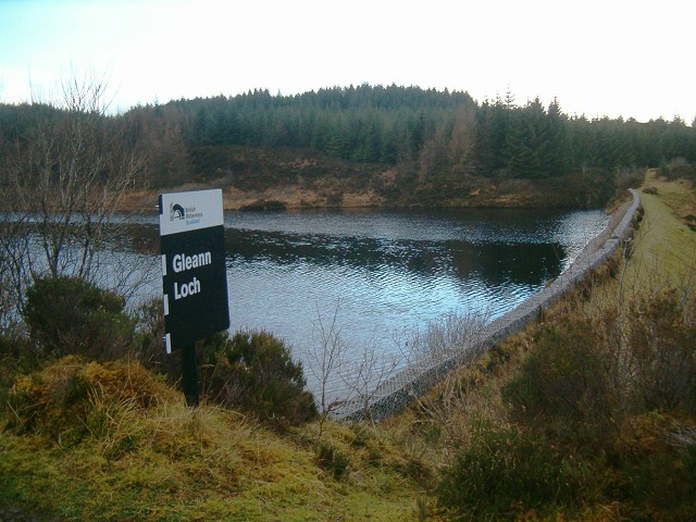
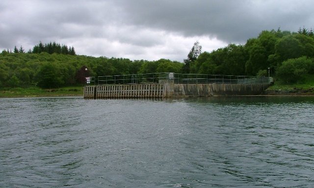
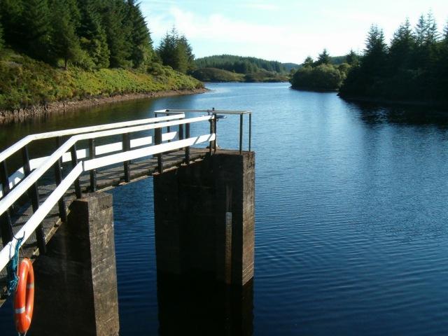
Gleann Loch

The loch runs south west to north east and is an impounding reservoir located to the west of Lochgilphead, Scotland. It is one of a number of lochs supplying...
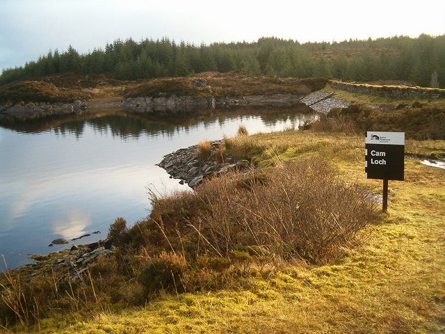
Cam Loch

Cam Loch (the Crooked Loch) is one of a number of water supply sources for the Crinan Canal. The impounding reservoir lies to the south of the canal and...

Daill Loch

Daill Loch is an impounding reservoir located 5 kilometres (3.1 mi) west north west of Lochgilphead and 1.5 kilometres (0.93 mi) south of the Crinan Canal...

Nearby Amenities

Located within 500m of 56.02544,-5.5660199
Source: PGS
Lat/Long: 56.0244527/-5.5734958
Source: PGS
Lat/Long: 56.0247543/-5.5730417
Source: PGS
Lat/Long: 56.0257455/-5.5704464
Source: PGS
Lat/Long: 56.0240768/-5.5682167
Source: PGS
Lat/Long: 56.0220505/-5.5689894
Source: PGS
Lat/Long: 56.0218611/-5.5692209
Source: PGS
Lat/Long: 56.0249244/-5.5725402
Source: PGS
Lat/Long: 56.0251671/-5.5720831
Source: PGS
Lat/Long: 56.0252953/-5.571787
Source: PGS
Lat/Long: 56.026219/-5.5697313
Source: PGS
Lat/Long: 56.0232955/-5.5691295
Source: PGS
Lat/Long: 56.0231737/-5.5691139
Source: PGS
Lat/Long: 56.0228281/-5.5683674
Achnamara
Name En: Achnamara
Name Gd: Achadh na Mara
Place: village
Wikidata: Q4673471
Wikipedia: en:Achnamara
Lat/Long: 56.0256088/-5.5656333
Bus Stop
Achnamara
Naptan AtcoCode: 60709465
Naptan NaptanCode: 54723493
Lat/Long: 56.0252289/-5.5663073
Power: pole
Lat/Long: 56.022949/-5.5679744
Power: pole
Lat/Long: 56.0237286/-5.5680713
Power: pole
Lat/Long: 56.0245247/-5.5680582
Power: pole
Lat/Long: 56.0252014/-5.5675369
Power: pole
Lat/Long: 56.0258694/-5.5670392
Power: pole
Lat/Long: 56.0263547/-5.5661774
Power: pole
Lat/Long: 56.0263254/-5.5661182
Power: pole
Lat/Long: 56.0272223/-5.5646165
Power: pole
Lat/Long: 56.0283812/-5.5637378
Power: pole
Lat/Long: 56.0287255/-5.5633463
Power: pole
Lat/Long: 56.0291285/-5.5636876
Power: pole
Lat/Long: 56.0298203/-5.5654112
Power: pole
Lat/Long: 56.0224424/-5.5685427
Power: pole
Lat/Long: 56.0226979/-5.5679188
Power: pole
Lat/Long: 56.0232142/-5.5680147
Power: pole
Lat/Long: 56.0256979/-5.5656777
Power: pole
Lat/Long: 56.0251415/-5.5662393
Power: pole
Lat/Long: 56.0254965/-5.5658802
Power: pole
Lat/Long: 56.0258907/-5.5654574
Power: pole
Lat/Long: 56.0277814/-5.5641926
Power: pole
Lat/Long: 56.0295608/-5.5640674
Power: pole
Lat/Long: 56.0262785/-5.5582937
Power: pole
Lat/Long: 56.0265973/-5.5594843
Power: pole
Lat/Long: 56.0269239/-5.5606456
Power: pole
Lat/Long: 56.0272477/-5.5618679
Power: pole
Lat/Long: 56.0273821/-5.5623684
Power: pole
Lat/Long: 56.0273821/-5.5629796
Power: pole
Lat/Long: 56.0276319/-5.5637843
Post Box
Operator: Royal Mail
Post Box Mounting: pier
Post Box Type: lamp
Ref: PA31 35
Royal Cypher: scottish_crown
Lat/Long: 56.0252106/-5.5663292
Defibrillator
Access: yes
Defibrillator Location: outside Achnamara Village Hall
Emergency: defibrillator
Indoor: no
Lat/Long: 56.0244774/-5.5666701
The data included in this document is from www.openstreetmap.org. The data is made available under ODbL.

Have you been to Achnamara?

Leave your review of Achnamara below (or comments, questions and feedback).