Macduff

Settlement in Banffshire

Scotland

Macduff

Mouse-ear Hawkweed Hawkweeds, Hawksbeards and Hawkbits all have dandelion-like flowers and are notoriously difficult to tell apart. This is the exception, instantly recognisable because its flowers are lemon-yellow, while all the others are more canary-yellow.
Mouse-ear Hawkweed Credit: Anne Burgess

Macduff is a picturesque coastal town located in the council area of Aberdeenshire, Scotland. Situated on the eastern coast of the country, it lies at the mouth of the River Deveron, overlooking the North Sea. With a population of around 4,000, Macduff is a close-knit community that offers a charming blend of history, natural beauty, and maritime tradition.

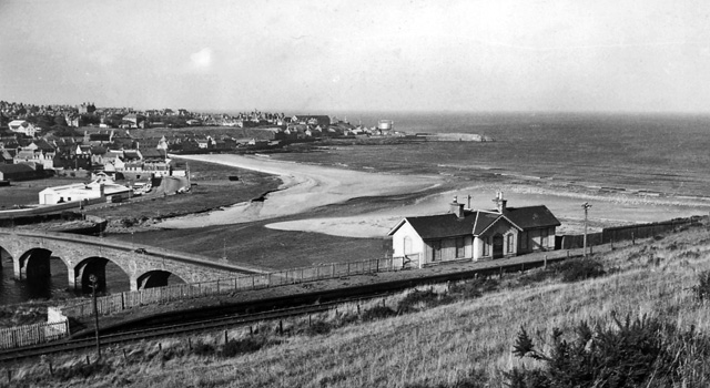
The town is known for its scenic coastline, featuring stunning sandy beaches and rugged cliffs that provide breathtaking views. The picturesque Macduff Harbour is a prominent feature, serving as a hub for fishing and leisure activities. Visitors can witness the lively activity of fishing boats bringing in their catch, creating a lively atmosphere.

Macduff also boasts a rich history, evident in its well-preserved architecture. The Macduff Marine Aquarium is a popular attraction, offering a fascinating insight into the diverse marine life found in the North Sea. The town is also home to Duff House, a magnificent Georgian mansion that now serves as an art gallery and cultural center.

In addition to its natural beauty and historical landmarks, Macduff hosts various events throughout the year, including the Macduff Harbour Day and the Macduff Arts Festival. These celebrations showcase local talent and bring the community together.

With a strong sense of community, stunning coastal scenery, and a rich historical background, Macduff offers visitors and residents alike a charming and vibrant place to live and explore.

If you have any feedback on the listing, please let us know in the comments section below.

Macduff Images

Images are sourced within 2km of 57.670047/-2.496341 or Grid Reference NJ7064. Thanks to Geograph Open Source API. All images are credited.

Mouse-ear Hawkweed Hawkweeds, Hawksbeards and Hawkbits all have dandelion-like flowers and are notoriously difficult to tell apart. This is the exception, instantly recognisable because its flowers are lemon-yellow, while all the others are more canary-yellow.
Mouse-ear Hawkweed
Hawkweeds, Hawksbeards and Hawkbits all have dandelion-like flowers and are notoriously difficult to tell apart. This is the exception, instantly recognisable because its flowers are lemon-yellow, while all the others are more canary-yellow.
Loch Craig In the foreground is the sea wall of the Tarlair open-air swimming pool. Loch craig is the sea inlet offshore. The ship is Petronordic, port of registry Nassau, which is a shuttle tanker, gross tonnage 54865.
Loch Craig
In the foreground is the sea wall of the Tarlair open-air swimming pool. Loch craig is the sea inlet offshore. The ship is Petronordic, port of registry Nassau, which is a shuttle tanker, gross tonnage 54865.
House Martin (Delichon urbica) There are half a dozen nests under the roof of the pavilion at the Tarlair swimming pool. Note the bird sitting in this nest, presumably incubating eggs.
House Martin (Delichon urbica)
There are half a dozen nests under the roof of the pavilion at the Tarlair swimming pool. Note the bird sitting in this nest, presumably incubating eggs.
Tarlair Lido, 2022 The monochrome emphasises the current state of disrepair of the pavilion, but that is set to change, as funding has been secured and listed building consent given for its refurbishment starting in 2022.
The Friends of Tarlair <span class="nowrap"><a title="http://friendsoftarlair.co.uk/" rel="nofollow ugc noopener" href="http://friendsoftarlair.co.uk/">Link</a><img style="margin-left:2px;" alt="External link" title="External link - shift click to open in new window" src="https://s1.geograph.org.uk/img/external.png" width="10" height="10"/></span> are working towards making this a vibrant leisure destination once again. The Category A Listed facility deserves nothing less.
Tarlair Lido, 2022
The monochrome emphasises the current state of disrepair of the pavilion, but that is set to change, as funding has been secured and listed building consent given for its refurbishment starting in 2022. The Friends of Tarlair LinkExternal link are working towards making this a vibrant leisure destination once again. The Category A Listed facility deserves nothing less.
Natural sloping slabs at Tarlair At the entrance to the lido.
Natural sloping slabs at Tarlair
At the entrance to the lido.
The road to Tarlair Looking towards Macduff. The building to the right of the road is the Well of Tarlair. It dates from c.1800. The chalybeate waters enjoyed considerable popularity for their medicinal and health giving properties in the NE during the 18th and 19th centuries.
The road to Tarlair
Looking towards Macduff. The building to the right of the road is the Well of Tarlair. It dates from c.1800. The chalybeate waters enjoyed considerable popularity for their medicinal and health giving properties in the NE during the 18th and 19th centuries.
Threading the needle View through the naatural arch known locally as the Needle's Eye
Threading the needle
View through the naatural arch known locally as the Needle's Eye
Tarlair Lido - the swimming pool The lowest of the three pools. The terraces were restored in 2014, and restoration of the pavilion is due to commence in 2022.
Tarlair Lido - the swimming pool
The lowest of the three pools. The terraces were restored in 2014, and restoration of the pavilion is due to commence in 2022.
Tarlair Lido, the three pools Nearest, surrounded by the narrow wall was a paddling pool, the next area being a boating pool with the main swimming pool furthest away. The surrounds of the pools were restored in 2014. The complex Listed Category A.
Tarlair Lido, the three pools
Nearest, surrounded by the narrow wall was a paddling pool, the next area being a boating pool with the main swimming pool furthest away. The surrounds of the pools were restored in 2014. The complex Listed Category A.
Tarlair Lido, view from the east Compare with this view of the lido in its heyday <span class="nowrap"><a title="http://friendsoftarlair.co.uk/welcome-to-friends-of-tarlair/about-us/" rel="nofollow ugc noopener" href="http://friendsoftarlair.co.uk/welcome-to-friends-of-tarlair/about-us/">Link</a><img style="margin-left:2px;" alt="External link" title="External link - shift click to open in new window" src="https://s1.geograph.org.uk/img/external.png" width="10" height="10"/></span>

Restoration of the pavilion is due to start in 2022. Listed Category A.
Tarlair Lido, view from the east
Compare with this view of the lido in its heyday LinkExternal link Restoration of the pavilion is due to start in 2022. Listed Category A.
Stagecoach Bluebird Macduff Bus Depot
Rock fall at near Tarlair
Macduff: a view over the harbour Looking over the harbour from the grassy hilltop to the south, where an anchor is ... anchored, by the <a href="https://www.geograph.org.uk/photo/451242">NJ7064 : Macduff: parish church</a>.
Macduff: a view over the harbour
Looking over the harbour from the grassy hilltop to the south, where an anchor is ... anchored, by the NJ7064 : Macduff: parish church.
View towards Macduff from Banff beach Macduff parish kirk is prominent on the hill with the unusual war memorial tower to the right.
View towards Macduff from Banff beach
Macduff parish kirk is prominent on the hill with the unusual war memorial tower to the right.
Macduff parish kirk Built 1805 (remodelled 1865) on a dramatic hilltop site overlooking Macduff harbour.  B-listed (LB37616): <span class="nowrap"><a title="http://portal.historicenvironment.scot/designation/LB37616" rel="nofollow ugc noopener" href="http://portal.historicenvironment.scot/designation/LB37616">Link</a><img style="margin-left:2px;" alt="External link" title="External link - shift click to open in new window" src="https://s1.geograph.org.uk/img/external.png" width="10" height="10"/></span> .
Macduff parish kirk
Built 1805 (remodelled 1865) on a dramatic hilltop site overlooking Macduff harbour. B-listed (LB37616): LinkExternal link .
Macduff war memorial An unusual and striking war memorial tower erected in 1920 and B-listed (LB37681):  <span class="nowrap"><a title="http://portal.historicenvironment.scot/designation/LB37631" rel="nofollow ugc noopener" href="http://portal.historicenvironment.scot/designation/LB37631">Link</a><img style="margin-left:2px;" alt="External link" title="External link - shift click to open in new window" src="https://s1.geograph.org.uk/img/external.png" width="10" height="10"/></span> .
Macduff war memorial
An unusual and striking war memorial tower erected in 1920 and B-listed (LB37681): LinkExternal link .
View of Macduff harbour from Church Street
Macduff town hall, 17 Shore Street The Scottish baronial town hall facing the harbour was designed by Aberdeen architects Pirie and Clyne in 1884 and is B-listed (LB37634): <span class="nowrap"><a title="http://portal.historicenvironment.scot/designation/LB37634" rel="nofollow ugc noopener" href="http://portal.historicenvironment.scot/designation/LB37634">Link</a><img style="margin-left:2px;" alt="External link" title="External link - shift click to open in new window" src="https://s1.geograph.org.uk/img/external.png" width="10" height="10"/></span> . Next door is the former Clydesdale Bank and agent's house, also B-listed (LB37635): <span class="nowrap"><a title="http://portal.historicenvironment.scot/designation/LB37635" rel="nofollow ugc noopener" href="http://portal.historicenvironment.scot/designation/LB37635">Link</a><img style="margin-left:2px;" alt="External link" title="External link - shift click to open in new window" src="https://s1.geograph.org.uk/img/external.png" width="10" height="10"/></span> .
Macduff town hall, 17 Shore Street
The Scottish baronial town hall facing the harbour was designed by Aberdeen architects Pirie and Clyne in 1884 and is B-listed (LB37634): LinkExternal link . Next door is the former Clydesdale Bank and agent's house, also B-listed (LB37635): LinkExternal link .
Show me another place!

Macduff is located at Grid Ref: NJ7064 (Lat: 57.670047, Lng: -2.496341)

Unitary Authority: Aberdeenshire

Police Authority: North East

What 3 Words

///prank.banter.seeing. Near Macduff, Aberdeenshire

Related Wikis

Macduff, Aberdeenshire

Macduff (Scottish Gaelic: An Dùn) is a town in the Banff and Buchan area of Aberdeenshire, Scotland. It is situated on Banff Bay and faces the town of...

Macduff Town Hall

Macduff Town Hall is a municipal building in Shore Street, Macduff, Aberdeenshire, Scotland. The structure, which was the meeting place of Macduff Burgh...

Macduff Lifeboat Station

Macduff Lifeboat Station is a Royal National Lifeboat Institution (RNLI) marine-rescue facility in Macduff, Aberdeenshire, Scotland, United Kingdom. The...

Macduff Marine Aquarium

Macduff Marine Aquarium is an aquarium in Macduff, Scotland. == History == Macduff Marine Aquarium opened in 1997.In 2017, the aquarium closed to allow...

Macduff railway station

Macduff railway station was a railway station serving the settlements of Banff and Macduff, Aberdeenshire, Scotland. It was the terminus of a branch line...

Deveronside F.C.

Deveronside Junior Football Club are a Scottish football club from the town of Banff. Members of the Scottish Junior Football Association, they currently...

Banff Bridge railway station

Banff Bridge railway station was a railway station in Banff Bridge, Banff, Aberdeenshire. It was the penultimate stop on a branch line from Inveramsay...
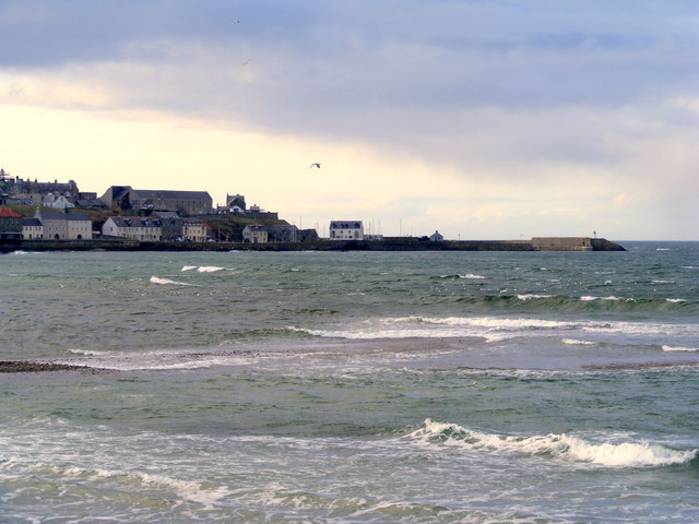
Banff Bay

Banff Bay (Scottish Gaelic: Bàgh Bhanbh) is a coastal embayment in Scotland situated between the towns of Banff, Aberdeenshire and Macduff, Aberdeenshire...

Nearby Amenities

Located within 500m of 57.670047,-2.496341
Source: Old Landsat image trace
Lat/Long: 57.6724195/-2.4921456
Source: Old Landsat image trace; NPE
Lat/Long: 57.6717449/-2.4892518
Macduff Pier
Man Made: lighthouse
Seamark Light 1 Character: Fl
Seamark Light 1 Colour: green
Seamark Light 1 Group: 2
Seamark Light 1 Height: 12
Seamark Light 1 Period: 6
Seamark Light 1 Sector End: 115
Seamark Light 1 Sector Start: 40
Seamark Light 1 Sequence: 1+(1),1+(3)
Seamark Light 2 Character: Fl
Seamark Light 2 Colour: white
Seamark Light 2 Group: 2
Seamark Light 2 Height: 12
Seamark Light 2 Period: 6
Seamark Light 2 Range: 9
Seamark Light 2 Sector End: 174
Seamark Light 2 Sector Start: 115
Seamark Light 2 Sequence: 1+(1),1+(3)
Seamark Light 3 Character: Fl
Seamark Light 3 Colour: red
Seamark Light 3 Group: 2
Seamark Light 3 Height: 12
Seamark Light 3 Period: 6
Seamark Light 3 Range: 7
Seamark Light 3 Sector End: 210
Seamark Light 3 Sector Start: 174
Seamark Light 3 Sequence: 1+(1),1+(3)
Seamark Light Reference: A 3348
Seamark Type: light_minor
Source: US NGA Pub. 114. 2011-05-26.
Lat/Long: 57.6709383/-2.500036
Source: Old Landsat image trace
Lat/Long: 57.6727232/-2.4933782
Source: Old Landsat image trace
Lat/Long: 57.6721407/-2.4907632
Macduff
Alt Name Gd: An Dùn
Name Gd: Dùn MhicDhuibh
Old Name: Doune
Place: town
Population: 3830
Source: npe
Wikidata: Q3778940
Wikipedia: en:Macduff, Aberdeenshire
Lat/Long: 57.6702105/-2.4944375
The Knowes War Memorial
Heritage Operator: Historic Environment Scotland
Heritage Website: https://portal.historicenvironment.scot/designation/LB37631
Historic: monument
Listed Status: Category B
Monument: war_memorial
Start Date: 1920
Wikidata: Q17774778
Lat/Long: 57.6677425/-2.4967488
Parking
Parking: surface
Lat/Long: 57.6721593/-2.4924463
Seamark Light Category: lower
Seamark Light Character: F
Seamark Light Colour: red
Seamark Light Height: 44
Seamark Light Range: 3
Seamark Light Reference: A 3350
Seamark Type: light_minor
Source: US NGA Pub. 114. 2011-05-26.
Lat/Long: 57.6688833/-2.4956667
Seamark Light Category: upper
Seamark Light Character: F
Seamark Light Colour: red
Seamark Light Height: 55
Seamark Light Range: 3
Seamark Light Reference: A 3350.1
Seamark Type: light_minor
Source: US NGA Pub. 114. 2011-05-26.
Lat/Long: 57.6685602/-2.4948618
Middle Basin
Alt Name: Macduff Harbour
Harbour: yes
Seamark Harbour Category: fishing
Seamark Type: harbour
Vhf: 12
Lat/Long: 57.6711999/-2.4983069
Barrier: bollard
Lat/Long: 57.6674561/-2.4976677
Bus Stop
Market Street
Bus: yes
Naptan AtcoCode: 630021581
Naptan Bearing: SE
Naptan CommonName: Market Street
Naptan Indicator: at
Naptan Landmark: Market Street
Naptan NaptanCode: 23624592
Naptan Street: Skene Road
Naptan Verified: no
Public Transport: platform
Ref: 23624592
Lat/Long: 57.6707692/-2.4932002
Bus Stop
Mill Street
Bus: yes
Naptan AtcoCode: 630021762
Naptan Bearing: E
Naptan CommonName: Mill Street
Naptan Indicator: at
Naptan Landmark: Mill Street
Naptan NaptanCode: 23629428
Naptan Street: Buchan Street
Naptan Verified: no
Public Transport: platform
Ref: 23629428
Lat/Long: 57.6700361/-2.4903765
Bus Stop
Mill Street
Bus: yes
Naptan AtcoCode: 630021761
Naptan Bearing: W
Naptan CommonName: Mill Street
Naptan Indicator: opp
Naptan Landmark: Mill Street
Naptan NaptanCode: 23624626
Naptan Street: Buchan Street
Naptan Verified: no
Public Transport: platform
Ref: 23624626
Lat/Long: 57.6699344/-2.4903367
Recycling
Lat/Long: 57.666825/-2.4976487
Bus Stop
Fife Street
Bus: yes
Naptan AtcoCode: 630021611
Naptan Bearing: NE
Naptan CommonName: Fife Street
Naptan Indicator: opp 27
Naptan Landmark: Fife Street
Naptan NaptanCode: 23624583
Naptan Street: Fife Street
Naptan Verified: no
Public Transport: platform
Ref: 23624583
Lat/Long: 57.6668719/-2.4970455
Bus Stop
Ross Street
Bus: yes
Naptan AtcoCode: 630026201
Naptan Bearing: NW
Naptan CommonName: Ross Street
Naptan Indicator: at
Naptan Landmark: Ross Street
Naptan NaptanCode: 23624627
Naptan Street: Duff Street
Naptan Verified: no
Public Transport: platform
Ref: 23624627
Lat/Long: 57.6672974/-2.4902451
Post Box
Post Box Type: wall
Ref: AB44 39D
Royal Cypher: GVIR
Royal Cypher Wikidata: Q33102169
Lat/Long: 57.667419/-2.4993331
Bus Stop
Lemonbank Place
Bus: yes
Naptan AtcoCode: 630026211
Naptan Bearing: SE
Naptan CommonName: Lemonbank Place
Naptan Indicator: at
Naptan Landmark: Lemonbank Place
Naptan NaptanCode: 23624623
Naptan Street: Duff Street
Naptan Verified: no
Public Transport: platform
Ref: 23624623
Lat/Long: 57.6681944/-2.4920967
College
Macduff Learning Centre
Lat/Long: 57.6658955/-2.4936601
Bus Stop
Bus: yes
Public Transport: platform
Lat/Long: 57.6694401/-2.4923969
Building: church
Old Name: Congregational Chapel
Shop: carpet
Lat/Long: 57.6688191/-2.4932363
Post Box
Post Box Type: wall
Ref: AB44 20D
Royal Cypher: GVIR
Royal Cypher Wikidata: Q33102169
Lat/Long: 57.6679555/-2.4915332
Post Box
Post Box Type: wall
Ref: AB44 19D
Royal Cypher: GR
Royal Cypher Wikidata: Q33102273
Lat/Long: 57.6698676/-2.4915949
Bus Stop
Union Road
Bus: yes
Naptan AtcoCode: 630021542
Naptan Bearing: SW
Naptan CommonName: Union Road
Naptan Indicator: SW bound
Naptan Landmark: Union Road
Naptan NaptanCode: 23624549
Naptan Street: Union Road
Naptan Verified: no
Public Transport: platform
Ref: 23624549
Lat/Long: 57.6684606/-2.5034707
Pub
The Old Moray
Lat/Long: 57.6705016/-2.4976379
Telephone
Booth: KX100
Covered: booth
Lat/Long: 57.6707871/-2.4977613
Bus Stop
Nicols Brae
Bench: yes
Bin: no
Bus: yes
Naptan AtcoCode: 630021572
Naptan Bearing: NE
Naptan CommonName: Nicols Brae
Naptan Indicator: NE bound
Naptan Landmark: Nicols Brae
Naptan NaptanCode: 23627879
Naptan Street: Shore Street
Naptan Verified: no
Public Transport: platform
Ref: 23627879
Shelter: yes
Tactile Paving: no
Lat/Long: 57.6707585/-2.4977655
Bus Stop
Union Road
Bus: yes
Naptan AtcoCode: 630021541
Naptan Bearing: NE
Naptan CommonName: Union Road
Naptan Indicator: NE bound
Naptan Landmark: Union Road
Naptan NaptanCode: 23627875
Naptan Street: Union Road
Naptan Verified: no
Public Transport: platform
Ref: 23627875
Lat/Long: 57.6685575/-2.5036542
Bus Stop
Hutcheon Street
Bench: no
Bin: no
Bus: yes
Naptan AtcoCode: 630021561
Naptan Bearing: NE
Naptan CommonName: Hutcheon Street
Naptan Indicator: opp
Naptan Landmark: Hutcheon Street
Naptan NaptanCode: 23627878
Naptan Street: Shore Street
Naptan Verified: no
Public Transport: platform
Ref: 23627878
Shelter: no
Tactile Paving: no
Lat/Long: 57.66958/-2.4994603
Bus Depot
Lat/Long: 57.66907/-2.502769
Bicycle Parking
Bicycle Parking: stands
Capacity: 4
Covered: no
Lat/Long: 57.6692436/-2.4945051
Bus Stop
Horns Brae
Bench: no
Bin: no
Bus: yes
Naptan AtcoCode: 630021551
Naptan Bearing: W
Naptan CommonName: Horns Brae
Naptan Indicator: at
Naptan Landmark: Horns Brae
Naptan NaptanCode: 23624569
Naptan Street: Union Road
Naptan Verified: no
Public Transport: platform
Ref: 23624569
Shelter: no
Tactile Paving: no
Lat/Long: 57.6690701/-2.5012864
Atm
Lat/Long: 57.67022/-2.497872
Bus Depot
Operator: Stagecoach
Lat/Long: 57.6687013/-2.5036327
Post Box
Collection Times: Mo-Fr 17:15; Sa 12:15
Note Collection Times: all the postboxes around Macduff say the last collection in Macduff is at the post office collection box at 16:00, but checked with the postmistress at the post office and the collection is definitely after 17:15 as stated on the box
Post Box Type: wall
Ref: AB44 46
Royal Cypher: no
Lat/Long: 57.6702383/-2.4968885
Bench
Lat/Long: 57.6692422/-2.4944649
Fast Food
Dolphin Fish & Chips
Cuisine: fish_and_chips
Lat/Long: 57.6706439/-2.4931788
Pub
Plough Inn
Lat/Long: 57.6709322/-2.4934631
Generator Method: photovoltaic
Generator Output Electricity: yes
Generator Source: solar
Generator Type: solar_photovoltaic_panel
Location: roof
Power: generator
Lat/Long: 57.6665681/-2.501286
Generator Method: photovoltaic
Generator Output Electricity: yes
Generator Source: solar
Generator Type: solar_photovoltaic_panel
Location: roof
Power: generator
Lat/Long: 57.665825/-2.4978688
Generator Method: photovoltaic
Generator Output Electricity: yes
Generator Source: solar
Generator Type: solar_photovoltaic_panel
Location: roof
Power: generator
Lat/Long: 57.6658466/-2.4977803
Generator Method: photovoltaic
Generator Output Electricity: yes
Generator Source: solar
Generator Type: solar_photovoltaic_panel
Location: roof
Power: generator
Lat/Long: 57.6667303/-2.4957714
Generator Method: photovoltaic
Generator Output Electricity: yes
Generator Source: solar
Generator Type: solar_photovoltaic_panel
Location: roof
Power: generator
Lat/Long: 57.6666571/-2.4955595
Generator Method: photovoltaic
Generator Output Electricity: yes
Generator Source: solar
Generator Type: solar_photovoltaic_panel
Location: roof
Power: generator
Lat/Long: 57.6672625/-2.4949801
Generator Method: photovoltaic
Generator Output Electricity: yes
Generator Source: solar
Generator Type: solar_photovoltaic_panel
Location: roof
Power: generator
Lat/Long: 57.6672782/-2.4950418
Generator Method: photovoltaic
Generator Output Electricity: yes
Generator Source: solar
Generator Type: solar_photovoltaic_panel
Location: roof
Power: generator
Lat/Long: 57.6676297/-2.4977347
Generator Method: photovoltaic
Generator Output Electricity: yes
Generator Source: solar
Generator Type: solar_photovoltaic_panel
Location: roof
Power: generator
Lat/Long: 57.6683341/-2.4939743
Generator Method: photovoltaic
Generator Output Electricity: yes
Generator Source: solar
Generator Type: solar_photovoltaic_panel
Location: roof
Power: generator
Lat/Long: 57.6686253/-2.4900502
Generator Method: photovoltaic
Generator Output Electricity: yes
Generator Source: solar
Generator Type: solar_photovoltaic_panel
Location: roof
Power: generator
Lat/Long: 57.6683082/-2.4894762
Generator Method: photovoltaic
Generator Output Electricity: yes
Generator Source: solar
Generator Type: solar_photovoltaic_panel
Location: roof
Power: generator
Lat/Long: 57.6681935/-2.4891865
Generator Method: photovoltaic
Generator Output Electricity: yes
Generator Source: solar
Generator Type: solar_photovoltaic_panel
Location: roof
Power: generator
Lat/Long: 57.6667173/-2.4929631
Generator Method: photovoltaic
Generator Output Electricity: yes
Generator Source: solar
Generator Type: solar_photovoltaic_panel
Location: roof
Power: generator
Lat/Long: 57.6666456/-2.4916166
Generator Method: photovoltaic
Generator Output Electricity: yes
Generator Source: solar
Generator Type: solar_photovoltaic_panel
Location: roof
Power: generator
Lat/Long: 57.6676957/-2.4930757
Generator Method: photovoltaic
Generator Output Electricity: yes
Generator Source: solar
Generator Type: solar_photovoltaic_panel
Location: roof
Power: generator
Lat/Long: 57.6693296/-2.4958706
Generator Method: photovoltaic
Generator Output Electricity: yes
Generator Source: solar
Generator Type: solar_photovoltaic_panel
Location: roof
Power: generator
Lat/Long: 57.6701355/-2.4911618
Generator Method: photovoltaic
Generator Output Electricity: yes
Generator Source: solar
Generator Type: solar_photovoltaic_panel
Location: roof
Power: generator
Lat/Long: 57.6670817/-2.4993789
Generator Method: photovoltaic
Generator Output Electricity: yes
Generator Source: solar
Generator Type: solar_photovoltaic_panel
Location: roof
Power: generator
Lat/Long: 57.6690671/-2.491512
Generator Method: photovoltaic
Generator Output Electricity: yes
Generator Source: solar
Generator Type: solar_photovoltaic_panel
Location: roof
Power: generator
Lat/Long: 57.6688978/-2.4918231
Generator Method: photovoltaic
Generator Output Electricity: yes
Generator Source: solar
Generator Type: solar_photovoltaic_panel
Location: roof
Power: generator
Lat/Long: 57.6688949/-2.4920002
Generator Method: photovoltaic
Generator Output Electricity: yes
Generator Source: solar
Generator Type: solar_photovoltaic_panel
Location: roof
Power: generator
Lat/Long: 57.6699507/-2.4882853
Generator Method: photovoltaic
Generator Output Electricity: yes
Generator Source: solar
Generator Type: solar_photovoltaic_panel
Location: roof
Power: generator
Lat/Long: 57.6698589/-2.4896318
Macduff Shipyards
Contact Website: https://www.macduffshipyards.co.uk/
Shop: boat
Lat/Long: 57.671959/-2.4961504
Give Way
Direction: backward
Lat/Long: 57.6679278/-2.4940288
Give Way
Direction: forward
Lat/Long: 57.6679628/-2.4941303
Give Way
Direction: forward
Lat/Long: 57.6677317/-2.4934577
Give Way
Direction: backward
Lat/Long: 57.6676975/-2.4933562
Give Way
Direction: forward
Lat/Long: 57.667401/-2.4924507
Give Way
Direction: backward
Lat/Long: 57.6673681/-2.4923483
Give Way
Direction: forward
Lat/Long: 57.667081/-2.4914376
Give Way
Direction: backward
Lat/Long: 57.6670463/-2.4913296
Bus Stop
James Street
Bus: yes
Naptan AtcoCode: 630026212
Naptan Bearing: NE
Naptan CommonName: James Street
Naptan Indicator: at
Naptan NaptanCode: 23634647
Naptan Street: Garden Street
Naptan Verified: no
Public Transport: platform
Ref: 23634647
Lat/Long: 57.6678605/-2.4932817
Bus Stop
Garden Street
Bus: yes
Naptan AtcoCode: 630026221
Naptan Bearing: NW
Naptan CommonName: Garden Street
Naptan Indicator: NW bound
Naptan Landmark: Garden Street
Naptan NaptanCode: 23624593
Naptan Street: Duff Street
Naptan Verified: no
Public Transport: platform
Ref: 23624593
Lat/Long: 57.6684822/-2.493065
Bus Stop
Fife Street
Bus: yes
Naptan AtcoCode: 630021631
Naptan Bearing: NW
Naptan CommonName: Fife Street
Naptan Indicator: opp 2a
Naptan Landmark: Fife Street
Naptan NaptanCode: 23624589
Naptan Street: Fife Street
Naptan Verified: no
Public Transport: platform
Ref: 23624589
Lat/Long: 57.6660061/-2.4933157
Bus Stop
McKay Road
Bus: yes
Naptan AtcoCode: 630021621
Naptan Bearing: SW
Naptan CommonName: McKay Road
Naptan Indicator: opp
Naptan Landmark: McKay Road
Naptan NaptanCode: 23624585
Naptan Street: Law of Doune Road
Naptan Verified: no
Public Transport: platform
Ref: 23624585
Lat/Long: 57.666183/-2.494977
Bus Stop
High Street
Bus: yes
Naptan AtcoCode: 630021602
Naptan Bearing: SW
Naptan CommonName: High Street
Naptan Indicator: SW bound
Naptan Landmark: High Street
Naptan NaptanCode: 23627895
Naptan Street: High Street
Naptan Verified: no
Public Transport: platform
Ref: 23627895
Lat/Long: 57.6695204/-2.4921443
Bus Stop
High Street
Bus: yes
Naptan AtcoCode: 630021601
Naptan Bearing: NE
Naptan CommonName: High Street
Naptan Indicator: NE bound
Naptan Landmark: High Street
Naptan NaptanCode: 23624598
Naptan Street: High Street
Naptan Verified: no
Public Transport: platform
Ref: 23624598
Lat/Long: 57.6695105/-2.4923181
Bus Stop
Gellymill Street
Bus: yes
Naptan AtcoCode: 630021592
Naptan Bearing: NW
Naptan CommonName: Gellymill Street
Naptan Indicator: at
Naptan Landmark: Gellymill Street
Naptan NaptanCode: 23624587
Naptan Street: Gellymill Street
Naptan Verified: no
Public Transport: platform
Ref: 23624587
Lat/Long: 57.671144/-2.4942895
Bus Stop
Town Hall
Bus: yes
Naptan AtcoCode: 630021562
Naptan Bearing: SW
Naptan CommonName: Town Hall
Naptan Indicator: at
Naptan Landmark: Town Hall
Naptan NaptanCode: 23624576
Naptan Street: Shore Street
Naptan Verified: no
Public Transport: platform
Ref: 23624576
Lat/Long: 57.6697291/-2.4985503
West Basin
Alt Name: West Harbour
Harbour: yes
Lat/Long: 57.6700938/-2.4990443
Princess Royal Basin
Harbour: yes
Lat/Long: 57.6723531/-2.4980931
Atm
Brand: NoteMachine
Brand Wikidata: Q104368525
Operator: NoteMachine
Operator Short: NMATM
Operator Wikidata: Q104368525
Lat/Long: 57.6699935/-2.4965781
Toilets
Female: yes
Gender Segregated: yes
Male: yes
Opening Hours: Apr-Sep 08:00-20:00; Oct-Mar 08:00-18:00; Dec 25-26,Jan 01-02 off
Lat/Long: 57.6714993/-2.4976844
Bench
Backrest: yes
Lat/Long: 57.6685919/-2.4963789
The data included in this document is from www.openstreetmap.org. The data is made available under ODbL.

Have you been to Macduff?

Leave your review of Macduff below (or comments, questions and feedback).