Boat Rock

Island in Wigtownshire

Scotland

Boat Rock

Memorial plaque Plaque dedicated to Sam Archer who went down with his vessel the Solway Hunter in 2003.
Memorial plaque Credit: Raymond Bell

Boat Rock is a small uninhabited island located off the coast of Wigtownshire, in the southwestern region of Scotland. Situated in the Irish Sea, it is part of the Solway Firth and lies approximately 1.5 miles southeast of the Mull of Galloway, Scotland's southernmost point.

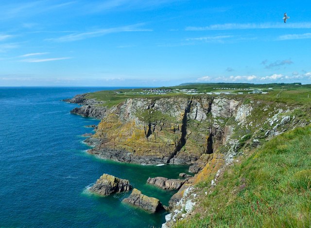
The island is characterized by its rugged and rocky terrain, with steep cliffs rising from the surrounding sea. Boat Rock gets its name from a large rock formation resembling a boat, prominently visible on its southern side. The rock serves as a nesting site for various seabirds, including guillemots and razorbills, making it an important location for birdwatchers and conservationists.

Access to the island is limited due to its remote location and challenging landscape. However, boat trips are occasionally organized for visitors to explore the area and observe the diverse wildlife. The surrounding waters are also popular among anglers, who come to fish for species such as mackerel and cod.

Boat Rock holds historical significance as well, with remnants of a small chapel dedicated to St. Ninian found on its eastern side. Thought to have been built in the 12th century, the chapel suggests a long history of human presence on the island.

Overall, Boat Rock offers a unique and picturesque destination for nature enthusiasts, providing opportunities for birdwatching, fishing, and glimpses into the region's past.

If you have any feedback on the listing, please let us know in the comments section below.

Boat Rock Images

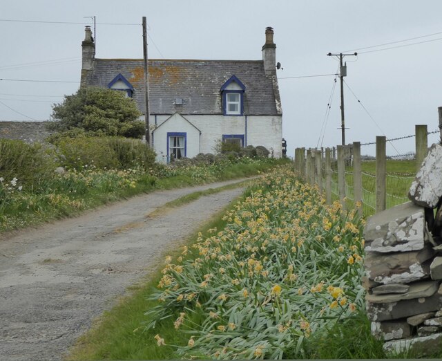
Images are sourced within 2km of 54.701795/-4.356855 or Grid Reference NX4836. Thanks to Geograph Open Source API. All images are credited.

Memorial plaque Plaque dedicated to Sam Archer who went down with his vessel the Solway Hunter in 2003.
Memorial plaque
Plaque dedicated to Sam Archer who went down with his vessel the Solway Hunter in 2003.
Overgrazing cattle? I have never seen so many cows in such a small field!
Overgrazing cattle?
I have never seen so many cows in such a small field!
Dry stone walls The walls in this area stand out with a white appearance. They provide an excellent habitat for mosses, lichens, and the wider ecosystem.
Prestrie farm on the horizon.
Dry stone walls
The walls in this area stand out with a white appearance. They provide an excellent habitat for mosses, lichens, and the wider ecosystem. Prestrie farm on the horizon.
Western tip of Isle Head Looking into Isle of Whithorn Bay.
Western tip of Isle Head
Looking into Isle of Whithorn Bay.
St Ninian’s Chapel, Isle of Whithorn St Ninian’s Chapel was first erected in the 1100s for the benefit of both local worshippers and pilgrims to St Ninian’s Shrine at Whithorn. The chapel we see today is a rebuild dating to about 1300.
This was the second Historic Environment Scotland site we visited and both were closed with no work taking place. The dangers walking round the rocks here far exceed any danger viewing this ruin!
St Ninian’s Chapel, Isle of Whithorn
St Ninian’s Chapel was first erected in the 1100s for the benefit of both local worshippers and pilgrims to St Ninian’s Shrine at Whithorn. The chapel we see today is a rebuild dating to about 1300. This was the second Historic Environment Scotland site we visited and both were closed with no work taking place. The dangers walking round the rocks here far exceed any danger viewing this ruin!
Another depressing visit! What an advert for visitors to Scotland!
Don't regret - get it fixed. Soon.
Another depressing visit!
What an advert for visitors to Scotland! Don't regret - get it fixed. Soon.
Getting the underside clean! Work goes on at the harbour at the Isle of Whithorn.
(Unlike at the closed St Ninian's Chapel.)
Getting the underside clean!
Work goes on at the harbour at the Isle of Whithorn. (Unlike at the closed St Ninian's Chapel.)
Cairnhead On Portyerrock Bay which is just over the hill.
Cairnhead
On Portyerrock Bay which is just over the hill.
Portyerrock Bay See how the bay has remnants of the Mulberry Harbour of WW2.
<span class="nowrap"><a title="https://www.youtube.com/watch?v=d4QswCbNfzU" rel="nofollow ugc noopener" href="https://www.youtube.com/watch?v=d4QswCbNfzU">Link</a><img style="margin-left:2px;" alt="External link" title="External link - shift click to open in new window" src="https://s1.geograph.org.uk/img/external.png" width="10" height="10"/></span>
Portyerrock Bay
See how the bay has remnants of the Mulberry Harbour of WW2. LinkExternal link
The southern tip of Isle Head On the Isle of Whithorn.
The southern tip of Isle Head
On the Isle of Whithorn.
The Cairn on Isle Head Looking over the Isle of Whithorn Bay.
The Cairn on Isle Head
Looking over the Isle of Whithorn Bay.
Isle of Whithorn Bay Beautiful day at the end of May (22nd).
Isle of Whithorn Bay
Beautiful day at the end of May (22nd).
St Ninian's Tearoom At the Isle of Whithorn.
St Ninian's Tearoom
At the Isle of Whithorn.
Main Street, Isle of Whithorn Leads round to the Harbour.
Main Street, Isle of Whithorn
Leads round to the Harbour.
Quay, Isle of Whithorn Viewed from the Car Park.
Quay, Isle of Whithorn
Viewed from the Car Park.
Harbour, Isle of Whithorn Serene Harbour at the end of May (22nd).
Harbour, Isle of Whithorn
Serene Harbour at the end of May (22nd).
Isle of Whithorn Harbour Lovely day at the end of May (22nd).
Isle of Whithorn Harbour
Lovely day at the end of May (22nd).
Harbour Row, Isle of Whithorn On a Beautiful day in May (22nd).
Harbour Row, Isle of Whithorn
On a Beautiful day in May (22nd).
Show me another place!

Boat Rock is located at Grid Ref: NX4836 (Lat: 54.701795, Lng: -4.356855)

Unitary Authority: Dumfries and Galloway

Police Authority: Dumfries and Galloway

What 3 Words

///handbag.cook.baths. Near Whithorn, Dumfries & Galloway

Related Wikis

Isle of Whithorn

Isle of Whithorn (Port Rosnait in Gaelic) is one of the most southerly villages and seaports in Scotland, lying on the coast north east of Burrow Head...

Burrow Head

Burrow Head is a headland located approximately two miles south-west of Isle of Whithorn, Wigtownshire, Scotland, and is the second southernmost point...

Candida Casa

Candida Casa was the name given to the church established by St Ninian in Whithorn, Galloway, southern Scotland, in the mid fifth century AD. The name...

Whithorn Priory

Whithorn Priory was a medieval Scottish monastery that also served as a cathedral, located at 6 Bruce Street in Whithorn, Wigtownshire, Dumfries and Galloway...

Nearby Amenities

Located within 500m of 54.701795,-4.356855
Source: PGS
Lat/Long: 54.6979301/-4.3585545
Source: PGS
Lat/Long: 54.6977398/-4.3602078
Source: PGS
Lat/Long: 54.6983567/-4.3592486
Source: PGS
Lat/Long: 54.6990815/-4.3593184
Source: PGS
Lat/Long: 54.6999532/-4.3601359
Source: PGS
Lat/Long: 54.70058/-4.3601778
Source: PGS
Lat/Long: 54.7004206/-4.358591
Source: PGS
Lat/Long: 54.7006723/-4.3594965
Source: PGS
Lat/Long: 54.7010059/-4.3575245
Source: PGS
Lat/Long: 54.7016178/-4.3569301
Source: PGS
Lat/Long: 54.7021726/-4.3566051
Source: PGS
Lat/Long: 54.7024057/-4.3561405
Source: PGS
Lat/Long: 54.702151/-4.355732
Source: PGS
Lat/Long: 54.702161/-4.354847
Source: PGS
Lat/Long: 54.702292/-4.354631
Source: PGS
Lat/Long: 54.702806/-4.354427
Source: PGS
Lat/Long: 54.7030002/-4.3533789
Source: PGS
Lat/Long: 54.7042103/-4.3530935
Source: PGS
Lat/Long: 54.7048903/-4.3523607
Source: PGS
Lat/Long: 54.7051302/-4.3519327
Isle of Whithorn
Name En: Isle of Whithorn
Name Gd: Port Rosnait
Name Sco: The Isle
Place: village
Lat/Long: 54.7007757/-4.3633686
St. Ninian's Chapel
Historic: ruins
Lat/Long: 54.6980617/-4.360698
Power: pole
Lat/Long: 54.7020699/-4.3631855
Power: pole
Lat/Long: 54.7043762/-4.3630784
Power: pole
Lat/Long: 54.703659/-4.3639167
Pub
The Steam Packet Inn
Lat/Long: 54.6988445/-4.3623461
Post Box
Collection Times: Mo-Fr 09:00; Sa 07:00
Operator: Royal Mail
Post Box Type: lamp
Ref: DG8 11D
Royal Cypher: scottish_crown
Lat/Long: 54.699282/-4.3620054
The data included in this document is from www.openstreetmap.org. The data is made available under ODbL.

Have you been to Boat Rock?

Leave your review of Boat Rock below (or comments, questions and feedback).