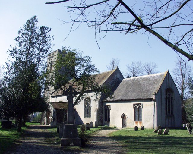
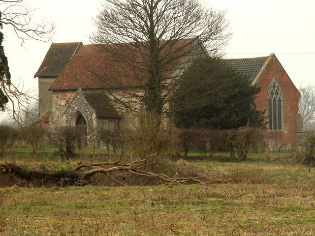
Bedingfield

Settlement in Suffolk Mid Suffolk

England

Bedingfield

Oilseed rape crop and woodland, Rishangles
Oilseed rape crop and woodland, Rishangles Credit: JThomas

Bedingfield is a small village located in the county of Suffolk, England. Situated approximately 5 miles east of Eye and 18 miles north of Ipswich, it is nestled in the heart of the picturesque countryside that characterizes this region.

With a population of around 200 residents, Bedingfield maintains a close-knit community feel. The village is primarily residential, consisting of a mix of traditional cottages and more modern houses. The architecture reflects the village's rich history, with some buildings dating back to the 17th century.

The village is surrounded by rolling farmland, offering beautiful views of the Suffolk countryside. Its rural location makes it an ideal place for those seeking a peaceful and tranquil lifestyle. The area is also known for its farming activities, with many residents involved in agriculture.

Despite its small size, Bedingfield boasts a number of amenities. The village is home to a local pub, The Bedingfield Arms, which serves as a popular meeting place for both locals and visitors. Additionally, there is a community hall that hosts various events and gatherings throughout the year.

For those seeking outdoor activities, Bedingfield provides ample opportunities for walking, cycling, and exploring the surrounding natural beauty. The village is also within close proximity to several nature reserves and country parks, making it an excellent base for nature enthusiasts.

Overall, Bedingfield offers a peaceful and picturesque place to call home, combining rural charm with convenient access to nearby towns and amenities.

If you have any feedback on the listing, please let us know in the comments section below.

Bedingfield Images

Images are sourced within 2km of 52.273979/1.193793 or Grid Reference TM1768. Thanks to Geograph Open Source API. All images are credited.

Oilseed rape crop and woodland, Rishangles
Eye Road (B1077)
Eye Road (B1077)
Cereal crop and woodland, Rishangles
Rishangles Baptist Church
The Olde Stores, Rishangles
Elizabeth II postbox, Rishangles Postbox No. IP23 7133.
Elizabeth II postbox, Rishangles
Postbox No. IP23 7133.
Church of St Mary, Bedingfield <span class="nowrap"><a title="https://historicengland.org.uk/listing/the-list/list-entry/1213550?section=official-list-entry" rel="nofollow ugc noopener" href="https://historicengland.org.uk/listing/the-list/list-entry/1213550?section=official-list-entry">Link</a><img style="margin-left:2px;" alt="External link" title="External link - shift click to open in new window" src="https://s1.geograph.org.uk/img/external.png" width="10" height="10"/></span>
Church of St Mary, Bedingfield
Interior of Church of St Mary, Bedingfield <span class="nowrap"><a title="https://historicengland.org.uk/listing/the-list/list-entry/1213550?section=official-list-entry" rel="nofollow ugc noopener" href="https://historicengland.org.uk/listing/the-list/list-entry/1213550?section=official-list-entry">Link</a><img style="margin-left:2px;" alt="External link" title="External link - shift click to open in new window" src="https://s1.geograph.org.uk/img/external.png" width="10" height="10"/></span>
Interior of Church of St Mary, Bedingfield
Church of St Mary, Bedingfield <span class="nowrap"><a title="https://historicengland.org.uk/listing/the-list/list-entry/1213550?section=official-list-entry" rel="nofollow ugc noopener" href="https://historicengland.org.uk/listing/the-list/list-entry/1213550?section=official-list-entry">Link</a><img style="margin-left:2px;" alt="External link" title="External link - shift click to open in new window" src="https://s1.geograph.org.uk/img/external.png" width="10" height="10"/></span>
Church of St Mary, Bedingfield
Bedingfield War Memorial <span class="nowrap"><a title="https://historicengland.org.uk/listing/the-list/list-entry/1452103?section=official-list-entry" rel="nofollow ugc noopener" href="https://historicengland.org.uk/listing/the-list/list-entry/1452103?section=official-list-entry">Link</a><img style="margin-left:2px;" alt="External link" title="External link - shift click to open in new window" src="https://s1.geograph.org.uk/img/external.png" width="10" height="10"/></span>
Bedingfield War Memorial
Rishangles church, now a private house
Bedingfield
Bedingfield
These buildings stand by Oak Farm, near Kenton According to the O/S map these buildings are part of, what is known as, Station Croft. It looks like they may be disused.
These buildings stand by Oak Farm, near Kenton
According to the O/S map these buildings are part of, what is known as, Station Croft. It looks like they may be disused.
Cottages by Fleming's Hall
Hall Road, looking towards Bedingfield
St. Mary's church at Bedingfield This view of the 14th century church, is from Manor Farm. Inside the church there is a splendid double-hammerbeam roof.
St. Mary's church at Bedingfield
This view of the 14th century church, is from Manor Farm. Inside the church there is a splendid double-hammerbeam roof.
A view of Park Farm
A view of Park Farm
Show me another place!

Bedingfield is located at Grid Ref: TM1768 (Lat: 52.273979, Lng: 1.193793)

Administrative County: Suffolk

District: Mid Suffolk

Police Authority: Suffolk

What 3 Words

///securing.mainly.buzzing. Near Debenham, Suffolk

Related Wikis

Southolt

Southolt is a village and civil parish in Suffolk, about 4+1⁄2 miles (7 km) southeast of Eye, on the road between Bedingfield and Worlingworth. == History... ==

Bedingfield

Bedingfield is a village and civil parish in the Mid Suffolk district of Suffolk, England. Rishangles and Southolt were included in the population at the...

Rishangles

Rishangles is a village and civil parish in the Mid Suffolk district of Suffolk in eastern England. The place-name 'Rishangles' is first attested in the...

Kenton railway station (Suffolk)

Kenton was a railway station on the Mid-Suffolk Light Railway. The station was located a mile north of the hamlet of Kenton. == History == Opened by the...

Redlingfield

Redlingfield is a village and civil parish in the Mid Suffolk district of Suffolk in eastern England. Located around six miles south-east of Diss, in 2011...

Aspall and Thorndon railway station

Aspall and Thorndon was a railway station on the Mid-Suffolk Light Railway. This station was located with Aspall to the south, Debenham 2.5 miles further...

Occold

Occold is a village in Suffolk, England. Occold is located 2 miles south east from the town of Eye, and 8 miles from the town of Diss. == History == In...

Kenton, Suffolk

Kenton is a village and civil parish in the Mid Suffolk district of Suffolk in eastern England. Located 1.9 miles to the north-east of Debenham, in 2005...

Nearby Amenities

Located within 500m of 52.273979,1.193793
Bedingfield
Created By: Potlatch 0.10b
Place: hamlet
Wikidata: Q3513561
Lat/Long: 52.2732616/1.1976042
Bus Stop
Church
Naptan AtcoCode: 390040742
Naptan Bearing: NE
Naptan BusStopType: CUS
Naptan CommonName: Church
Naptan Indicator: adj
Naptan Landmark: Church
Naptan NaptanCode: sufgawja
Naptan Street: Park Road
Naptan Verified: no
Source: naptan_import
Lat/Long: 52.2737861/1.1943868
Bus Stop
Church
Naptan AtcoCode: 390040743
Naptan Bearing: SW
Naptan BusStopType: CUS
Naptan CommonName: Church
Naptan Indicator: opp
Naptan Landmark: Church
Naptan NaptanCode: sufgawjd
Naptan Street: Park Road
Naptan Verified: no
Source: naptan_import
Lat/Long: 52.2737482/1.1944573
Defibrillator
Access: yes
Defibrillator Location: On the right-hand side of the village hall
Emergency: defibrillator
Indoor: no
Operator: Community Heartbeat Trust
Ref: CHT-9669
Ref GB The Circuit: 8C758B5D-02D5-49C6-B7C0-AE1101101EB6
Lat/Long: 52.2735795/1.1945594
The data included in this document is from www.openstreetmap.org. The data is made available under ODbL.

Have you been to Bedingfield?

Leave your review of Bedingfield below (or comments, questions and feedback).