Suidhe nan Eun

Island in Inverness-shire

Scotland

Suidhe nan Eun

Beach at Elgol Looking along the beach at Elgol towards the Cullin Hills.
Beach at Elgol Credit: Ajay Tegala

Suidhe nan Eun is a small island located in the Inverness-shire region of Scotland. Situated in the Inner Hebrides, it is part of the group of islands known as the Small Isles. The island covers an area of approximately 0.5 square kilometers and has a population of around 10 people.

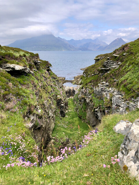
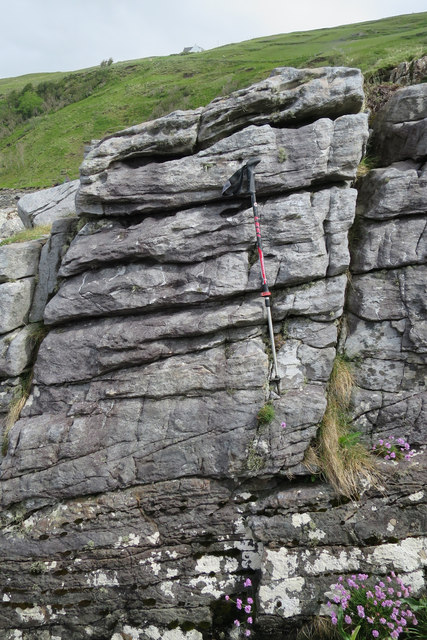
Suidhe nan Eun is characterized by its rugged and picturesque landscapes. It is primarily made up of rolling hills and rocky terrain, with scattered patches of grassland and heather. The island is surrounded by the clear waters of the Atlantic Ocean, offering breathtaking views of the surrounding sea and nearby islands.

Despite its small size, Suidhe nan Eun boasts a rich biodiversity. The island is home to a variety of bird species, including the iconic sea eagle and puffins. It also supports a diverse range of plant life, with heather, wildflowers, and mosses covering the landscape.

The island has limited infrastructure, with a small number of houses and basic amenities for its residents. There are no roads, and transportation is mainly done by foot or by boat. The island offers a peaceful and remote environment, making it an attractive destination for those seeking solitude and tranquility.

Suidhe nan Eun is a place of natural beauty and tranquility, offering visitors a chance to immerse themselves in the stunning landscapes and wildlife of the Scottish Highlands.

If you have any feedback on the listing, please let us know in the comments section below.

Suidhe nan Eun Images

Images are sourced within 2km of 57.13613/-6.1112053 or Grid Reference NG5112. Thanks to Geograph Open Source API. All images are credited.

Beach at Elgol Looking along the beach at Elgol towards the Cullin Hills.
Beach at Elgol
Looking along the beach at Elgol towards the Cullin Hills.
The Cuillin from Elgol Classic view across Loch Scavaig.
The Cuillin from Elgol
Classic view across Loch Scavaig.
Filled in Geodh—Suidhe nan Eun
Just another view of the bridges over Allt Port na Cullaidh
Bridge over Allt Port na Cullaidh
Loch Scavaig
Loch Scavaig
View over Elgol from the upper car park Quite a stiff climb up to here if the lower car park is full!
View over Elgol from the upper car park
Quite a stiff climb up to here if the lower car park is full!
Waterfront, Elgol
Waterfront, Elgol
Misty Isle Ferry Passengers en route from Elgol to Lochs Scavaig and Coruisk.
Misty Isle Ferry
Passengers en route from Elgol to Lochs Scavaig and Coruisk.
The harbour at Elgol Isle of Skye
The harbour at Elgol
Isle of Skye
Camp on the moor above Elgol
Shingle shore at Elgol Marsco stands through the gap with Blaven on the right.
Shingle shore at Elgol
Marsco stands through the gap with Blaven on the right.
Foreshore Rocks This shows a sill overlying some black shale on the beach at Elgol. The shale is the Cullaidh Shale Formation, the lowest unit of the Great Estuarine Group of Jurassic sedimentary rocks.
Foreshore Rocks
This shows a sill overlying some black shale on the beach at Elgol. The shale is the Cullaidh Shale Formation, the lowest unit of the Great Estuarine Group of Jurassic sedimentary rocks.
Elgol Sandstone The weathered face of the cliff at the north end of the beach at Elgol is known to many non-geologists, even though they may not be aware of the explanation for the weathering. The hollows are thought to have been started by salt crystallising in the sandstone, and displacing sand grains, rather like the effect of freezing and thawing of ice. The resulting weakness in the rock was then further exploited by wind and sea to produce the honeycomb effect. Notice that the further up the face, the larger the holes.
Elgol Sandstone
The weathered face of the cliff at the north end of the beach at Elgol is known to many non-geologists, even though they may not be aware of the explanation for the weathering. The hollows are thought to have been started by salt crystallising in the sandstone, and displacing sand grains, rather like the effect of freezing and thawing of ice. The resulting weakness in the rock was then further exploited by wind and sea to produce the honeycomb effect. Notice that the further up the face, the larger the holes.
Igneous Dyke The coastline here is of Elgol Sandstone, but it is cut by a swarm of Palaeogene dykes. In this case the dyke has weathered out, leaving a slot through the sandstone.
Igneous Dyke
The coastline here is of Elgol Sandstone, but it is cut by a swarm of Palaeogene dykes. In this case the dyke has weathered out, leaving a slot through the sandstone.
Elgol Sandstone This face of the sandstone shows cross-bedding, which allows geologists to deduce that it was deposited in a fluvio-deltaic environment. It is of Bathonian (Middle Jurassic) age, formed about 168 million years ago.
Elgol Sandstone
This face of the sandstone shows cross-bedding, which allows geologists to deduce that it was deposited in a fluvio-deltaic environment. It is of Bathonian (Middle Jurassic) age, formed about 168 million years ago.
Elgol Sandstone The sandstone is of Middle Jurassic age, laid down about 168 million years ago. It has weathered along cracks and joints to form a complicated surface. In the background we should be able to see the Black Cuillins.
Elgol Sandstone
The sandstone is of Middle Jurassic age, laid down about 168 million years ago. It has weathered along cracks and joints to form a complicated surface. In the background we should be able to see the Black Cuillins.
A Large Dyke The dark rock standing proud of the surroundings is a large igneous dyke, one of a swarm of Palaeogene dykes that cuts across the Jurassic sandstones here.
A Large Dyke
The dark rock standing proud of the surroundings is a large igneous dyke, one of a swarm of Palaeogene dykes that cuts across the Jurassic sandstones here.
Show me another place!

Suidhe nan Eun is located at Grid Ref: NG5112 (Lat: 57.13613, Lng: -6.1112053)

Unitary Authority: Highland

Police Authority: Highlands and Islands

What 3 Words

///colder.preparing.grant. Near Elgol, Highland

Related Wikis

Strathaird

Strathaird is a peninsula on the island of Skye, Scotland, situated between Loch Slapin and Loch Scavaig on the south coast.W. H. Murray said that "Skye...

Elgol

Elgol (Scottish Gaelic: Ealaghol) is a village on the shores of Loch Scavaig towards the end of the Strathaird peninsula in the Isle of Skye, in the Scottish...

Kilmarie

Kilmarie or Kilmaree (Scottish Gaelic: Cill Ma Ruibhe), (Gaelic: cill =' church or cell'; marie from St. Maolrubha) is a village in the Isle of Skye, Scotland...

Dun Ringill

Dun Ringill (Gaelic: Dùn, 'fort', Ringill, 'point of the ravine') is an Iron Age hill fort on the Strathaird peninsula on the island of Skye, Scotland...

Nearby Amenities

Located within 500m of 57.13613,-6.1112053
Source: PGS
Lat/Long: 57.1402129/-6.1129133
Created By: dmgroom_coastlines
Source: PGS
Lat/Long: 57.14006/-6.11268
Source: PGS
Lat/Long: 57.1397588/-6.1125485
Source: PGS
Lat/Long: 57.1395958/-6.1120765
Created By: dmgroom_coastlines
Source: PGS
Lat/Long: 57.13927/-6.11179
Created By: dmgroom_coastlines
Source: PGS
Lat/Long: 57.13903/-6.11229
Created By: dmgroom_coastlines
Source: PGS
Lat/Long: 57.13877/-6.1123
Source: PGS
Lat/Long: 57.1390253/-6.1129562
Source: PGS
Lat/Long: 57.1378028/-6.1133854
Source: PGS
Lat/Long: 57.1372204/-6.1130773
Source: PGS
Lat/Long: 57.1370231/-6.1127692
Source: PGS
Lat/Long: 57.1367021/-6.1122824
Source: PGS
Lat/Long: 57.1363979/-6.1119497
Source: PGS
Lat/Long: 57.1363745/-6.1117463
Source: PGS
Lat/Long: 57.1366216/-6.1114584
Source: PGS
Lat/Long: 57.1364772/-6.111337
Source: PGS
Lat/Long: 57.1361414/-6.1113889
Source: PGS
Lat/Long: 57.1359289/-6.1110939
Source: PGS
Lat/Long: 57.1358113/-6.1098553
Source: PGS
Lat/Long: 57.1354388/-6.1097012
Source: PGS
Lat/Long: 57.1352589/-6.109449
Source: PGS
Lat/Long: 57.1346724/-6.1084989
Source: PGS
Lat/Long: 57.1343982/-6.1082894
Source: PGS
Lat/Long: 57.1341699/-6.1077635
Source: PGS
Lat/Long: 57.1342397/-6.1067335
Source: PGS
Lat/Long: 57.1345425/-6.1052958
Source: PGS
Lat/Long: 57.134461/-6.1045234
Source: PGS
Lat/Long: 57.1343678/-6.103944
Prince Charles' Cave
Name Gd: Uamh a' Phrionnsa
Natural: cave_entrance
Lat/Long: 57.1349649/-6.1057177
Tourism: viewpoint
Lat/Long: 57.1364823/-6.1116405
Viewpoint Prince Charles' Cave
Tourism: viewpoint
Lat/Long: 57.1343957/-6.1075621
The data included in this document is from www.openstreetmap.org. The data is made available under ODbL.

Have you been to Suidhe nan Eun?

Leave your review of Suidhe nan Eun below (or comments, questions and feedback).