Am Baisteir

Island in Argyllshire

Scotland

Am Baisteir

Three white rocks on heather The rocks are on heather moorland north-west of Beinn Mhòr which is the distant hill.
Three white rocks on heather Credit: Trevor Littlewood

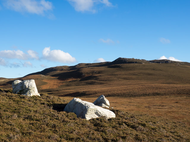
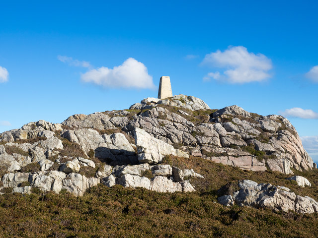
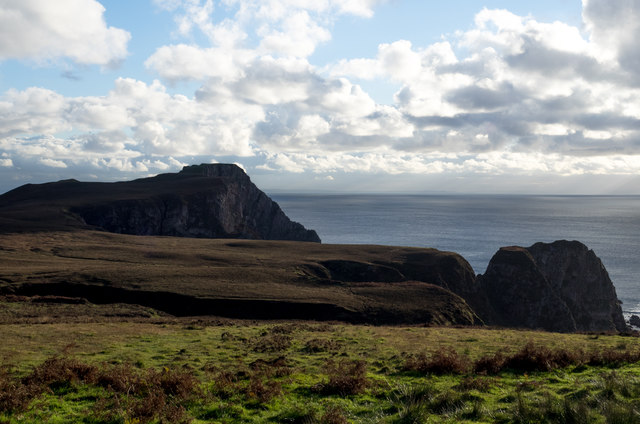
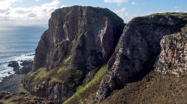
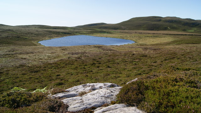
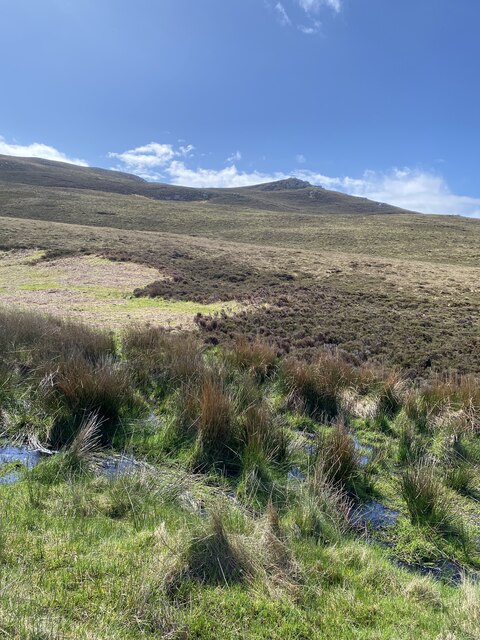
Am Baisteir is a small island located in Argyllshire, Scotland. It is situated in the Inner Hebrides, specifically in the Sound of Mull. With an area of approximately 2 square miles, Am Baisteir is known for its rugged and mountainous terrain.

The island is predominantly composed of rocky hills and cliffs, making it a popular destination for hikers and climbers. One of its notable features is the peak of Am Baisteir itself, which stands at an impressive height of 2,543 feet, offering breathtaking panoramic views of the surrounding area.

The island is home to a diverse range of flora and fauna, including various species of seabirds, such as puffins and gannets. Additionally, visitors may spot seals and dolphins swimming in the surrounding waters.

Due to its remote location, Am Baisteir is largely uninhabited, with only a few scattered cottages and farm buildings. This adds to the island's charm and provides an opportunity for those seeking solitude and tranquility.

Access to Am Baisteir is primarily by boat, with regular ferry services operating from nearby ports. The island is also a popular destination for boat trips and wildlife tours, allowing visitors to explore its natural beauty and observe the abundant wildlife.

Overall, Am Baisteir offers a unique and unspoiled experience for nature lovers and adventurers, with its stunning landscapes, diverse wildlife, and peaceful atmosphere making it a hidden gem within Argyllshire.

If you have any feedback on the listing, please let us know in the comments section below.

Am Baisteir Images

Images are sourced within 2km of 55.579846/-6.2821914 or Grid Reference NR3040. Thanks to Geograph Open Source API. All images are credited.

Three white rocks on heather The rocks are on heather moorland north-west of Beinn Mhòr which is the distant hill.
Three white rocks on heather
The rocks are on heather moorland north-west of Beinn Mhòr which is the distant hill.
Trig point atop rock plinth The triangulation column is at the summit of Beinn Mhòr on The Oa peninsula, of Islay.
Trig point atop rock plinth
The triangulation column is at the summit of Beinn Mhòr on The Oa peninsula, of Islay.
Heather moorland beyond bracken Beyond the heather lies Beinn Mhòr and Dùn Athad is to the right of the notch against the sea.
Heather moorland beyond bracken
Beyond the heather lies Beinn Mhòr and Dùn Athad is to the right of the notch against the sea.
East face of Dùn Athad Dùn Athad is a striking feature of the south coast of The Oa.
It's attached to the bulk of the peninsula by a narrow neck of land which is possible, with care, to cross safely so to reach the summit; there's not the vertical rock step that might be suspected from the image.
East face of Dùn Athad
Dùn Athad is a striking feature of the south coast of The Oa. It's attached to the bulk of the peninsula by a narrow neck of land which is possible, with care, to cross safely so to reach the summit; there's not the vertical rock step that might be suspected from the image.
View towards Dun Athad from near the Mull of Oa
Trigpoint, Beinn Mhor, Islay
Loch na Beinne View of Loch na Beinne from the west on high ground.
Loch na Beinne
View of Loch na Beinne from the west on high ground.
Highland cow in Kinnabus Loch Cow standing in shallow water of Kinnabus Loch
Highland cow in Kinnabus Loch
Cow standing in shallow water of Kinnabus Loch
Beinn Mhor Fourth Marilyn and second trig of the day after the American Monument with vaste wide views at 20:00. 
Name: Beinn Mhor
Hill number: 1471
Height: 202m / 663ft
Area: 20B: Islay
Class: Ma
Grid ref: NR 29481 40455
Summit feature: trig point
Drop: 177m
Col: 25m  NR347477
Beinn Mhor
Fourth Marilyn and second trig of the day after the American Monument with vaste wide views at 20:00. Name: Beinn Mhor Hill number: 1471 Height: 202m / 663ft Area: 20B: Islay Class: Ma Grid ref: NR 29481 40455 Summit feature: trig point Drop: 177m Col: 25m NR347477
Dùn Athad Seen from across Port nan Gallan on the path from the American Monument to Upper Killeyan, with Beinn Mhòr on the left.
Dùn Athad
Seen from across Port nan Gallan on the path from the American Monument to Upper Killeyan, with Beinn Mhòr on the left.
Beinn Mhòr, Islay Viewed from the sea. Beinn Mhòr (Big Mountain) is one of Islay's seven marilyns - A Marilyn is a mountain or hill in the United Kingdom, Republic of Ireland or Isle of Man with a relative height of at least 150 metres (492 ft), regardless of absolute height or other merit. (Wikipedia) It is also adorned by one of Islay's 35 trigpoints.
Beinn Mhòr, Islay
Viewed from the sea. Beinn Mhòr (Big Mountain) is one of Islay's seven marilyns - A Marilyn is a mountain or hill in the United Kingdom, Republic of Ireland or Isle of Man with a relative height of at least 150 metres (492 ft), regardless of absolute height or other merit. (Wikipedia) It is also adorned by one of Islay's 35 trigpoints.
Dùn Athad and Beinn Mhòr, Islay This incredible dùn juts out into the sea. It is barely accessible from the land and commands an excellent vantage point over the southern seas of the island. Aerially it is possible to see its flat top, difficult to imagine from this angle.
Dùn Athad and Beinn Mhòr, Islay
This incredible dùn juts out into the sea. It is barely accessible from the land and commands an excellent vantage point over the southern seas of the island. Aerially it is possible to see its flat top, difficult to imagine from this angle.
Moorland to the east of the Mull of Oa Just inland from the cliffs on the south coast of Islay. Beinn Mhor <a href="https://www.geograph.org.uk/gridref/NR2940">NR2940</a> dominates the skyline.
Moorland to the east of the Mull of Oa
Just inland from the cliffs on the south coast of Islay. Beinn Mhor NR2940 dominates the skyline.
Dùn Athad A dun on a promontory which is linked to the mainland by a natural causeway. 
For an aerial photo see: <span class="nowrap"><a title="http://www.scotlandsplaces.gov.uk/record/rcahms/37290/islay-dun-athad/rcahms" rel="nofollow ugc noopener" href="http://www.scotlandsplaces.gov.uk/record/rcahms/37290/islay-dun-athad/rcahms">Link</a><img style="margin-left:2px;" alt="External link" title="External link - shift click to open in new window" src="https://s1.geograph.org.uk/img/external.png" width="10" height="10"/></span>
Dùn Athad
A dun on a promontory which is linked to the mainland by a natural causeway. For an aerial photo see: LinkExternal link
Beinn Mhor summit, The Oa, Islay View from Beinn Mhor summit, The Oa, Islay looking in a westerly direction along the coast to the American Monument in the far distance.
Beinn Mhor summit, The Oa, Islay
View from Beinn Mhor summit, The Oa, Islay looking in a westerly direction along the coast to the American Monument in the far distance.
Views to Dun Athad and Mull of Oa
Onwards and upwards towards Beinn Mhor
Nearly there Beinn Mhor in the distance
Show me another place!

Am Baisteir is located at Grid Ref: NR3040 (Lat: 55.579846, Lng: -6.2821914)

Unitary Authority: Argyll and Bute

Police Authority: Argyll and West Dunbartonshire

What 3 Words

///reactions.directs.dissolves. Near Port Ellen, Argyll & Bute

Related Wikis

Eas Mòr, upper

Eas Mor is a waterfall is a waterfall on the Abhainn Ghil on the island of Islay in Scotland. It lies on The Oa peninsula south of Giol and west of Lenavore...

The Oa

The Oa ( OH) (Scottish Gaelic: An Obha) is a rocky peninsula in the southwest of the island of Islay, in Argyll, Scotland. It is an RSPB nature reserve...

Eas Mòr, lower

Eas Mor (lower) is a waterfall on the Abhainn Ghil on the island of Islay, in Scotland. It lies on the west coast of The Oa peninsula north of Lower Killeyan...

Port Ellen distillery

Port Ellen distillery is located in Port Ellen on the isle of Islay, Scotland. It initially operated between 1825 and 1983 when production shut down....

St John's Church, Port Ellen

St John's Church, Port Ellen is a Category B listed building in Port Ellen, Islay, Argyll and Bute, Scotland. == History == The memorial stone for the...

Port Ellen

Port Ellen (Scottish Gaelic: Port Ìlein) is a small town on the island of Islay, in Argyll, Scotland. The town is named after the wife of its founder,...

Machrie golf course

The Machrie Golf Course, or "The Machrie Links", is located on Islay, in Scotland. The word "machrie" is a corruption of the Scottish Gaelic machair, which...

Texa

Texa (Scottish Gaelic: Teacsa) is a small island 700 metres (3⁄8 mile) directly south of Islay, in the Inner Hebrides, Scotland. It reaches a height of...

Have you been to Am Baisteir?

Leave your review of Am Baisteir below (or comments, questions and feedback).