Eilean nan Gortanan

Island in Argyllshire

Scotland

Eilean nan Gortanan

Boat under repair
Boat under repair Credit: Mick Garratt

Eilean nan Gortanan is a small island located in Argyllshire, Scotland. With a total area of approximately 0.1 square kilometers, this picturesque island is situated in the Sound of Mull, near the western coast of the country.

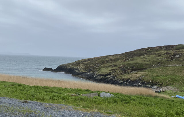
The island is characterized by its rugged and rocky terrain, covered in patches of lush green vegetation. It has a few small hills that offer stunning panoramic views of the surrounding landscape. The shoreline is jagged and indented, with small sandy beaches scattered along its edges.

Eilean nan Gortanan is uninhabited and does not have any permanent structures or facilities. It is a popular destination for outdoor enthusiasts, nature lovers, and birdwatchers due to its diverse wildlife. The island is home to various species of birds, including gulls, cormorants, and puffins, making it an excellent spot for birdwatching.

Access to the island is possible by private boat or by booking a guided tour. Visitors can explore the island's rugged beauty, go for walks, and enjoy the tranquility of the surrounding waters. The crystal-clear waters around the island are ideal for snorkeling and diving, allowing visitors to discover the rich marine life that inhabits the area.

Eilean nan Gortanan is a hidden gem in Argyllshire, offering a unique and immersive experience for those seeking a peaceful retreat in the midst of Scotland's stunning natural landscapes.

If you have any feedback on the listing, please let us know in the comments section below.

Eilean nan Gortanan Images

Images are sourced within 2km of 55.674697/-6.4999034 or Grid Reference NR1751. Thanks to Geograph Open Source API. All images are credited.

Boat under repair
Boat under repair
Main Street, Port Wemyss/Bun Othan
Caolas na Cor-sgeire
Coast at Claddach
Coast at Claddach
Main Street, Port Wemyss/Bun Othan
Village Hall
Village Hall
Coastal views from holiday cottage
Portnahaven
Portnahaven
Views out to sea Portnahaven
Portnahaven, Parish Church
OS Cut Mark - Portnahaven, Parish Church <span class="nowrap"><a title="https://www.bench-marks.org.uk/bm58120" rel="nofollow ugc noopener" href="https://www.bench-marks.org.uk/bm58120">Link</a><img style="margin-left:2px;" alt="External link" title="External link - shift click to open in new window" src="https://s1.geograph.org.uk/img/external.png" width="10" height="10"/></span>
OS Cut Mark - Portnahaven, Parish Church
View to Orsay from Port Wemyss
Port Ellister
Port Ellister
Location of Cnoc Undail OS Pipe <span class="nowrap"><a title="http://trigpointing.uk/trig/9482" rel="nofollow ugc noopener" href="http://trigpointing.uk/trig/9482">Link</a><img style="margin-left:2px;" alt="External link" title="External link - shift click to open in new window" src="https://s1.geograph.org.uk/img/external.png" width="10" height="10"/></span>
Location of Cnoc Undail OS Pipe
Former Portnahaven Coast Guard Lookout
Portnahaven
Portnahaven
Former school, Portnahaven Now a holiday let.
Former school, Portnahaven
Now a holiday let.
OS Cut Mark - Portnahaven, Old School <span class="nowrap"><a title="https://www.bench-marks.org.uk/bm58122" rel="nofollow ugc noopener" href="https://www.bench-marks.org.uk/bm58122">Link</a><img style="margin-left:2px;" alt="External link" title="External link - shift click to open in new window" src="https://s1.geograph.org.uk/img/external.png" width="10" height="10"/></span>
OS Cut Mark - Portnahaven, Old School
Show me another place!

Eilean nan Gortanan is located at Grid Ref: NR1751 (Lat: 55.674697, Lng: -6.4999034)

Unitary Authority: Argyll and Bute

Police Authority: Argyll and West Dunbartonshire

What 3 Words

///thanks.launcher.sending. Near Portnahaven, Argyll & Bute

Related Wikis

Portnahaven

Portnahaven (Scottish Gaelic: Port na h-Abhainne, meaning river port) is a village on Islay in the Inner Hebrides, Scotland. The village is within the...

Orsay, Inner Hebrides

Orsay (Scottish Gaelic: Orasaigh) is a small island in the Inner Hebrides of Scotland. It lies a short distance off the west coast of the island of Islay...

Eilean Mhic Coinnich

Eilean Mhic Coinnich, also known as Mackenzie Island (although recorded on the Land Register as McKenseys Island), is an uninhabited island of 17.3 hectares...

Islay LIMPET

Islay LIMPET was the world's first commercial wave power device and was connected to the United Kingdom's National Grid. == History == Islay LIMPET (Land...

Nearby Amenities

Located within 500m of 55.674697,-6.4999034
Port Wemyss
Name En: Port Wemyss
Name Gd: Bun Othain
Place: village
Wikidata: Q1747432
Lat/Long: 55.6766674/-6.5051379
Bus Stop
Naptan AtcoCode: 60709357
Naptan NaptanCode: 54723234
Shelter: yes
Lat/Long: 55.6762188/-6.5054353
Post Box
Post Box Type: wall
Ref: PA47 10
Royal Cypher: scottish_crown
Lat/Long: 55.676299/-6.5054353
Telephone
Booth: K6
Covered: booth
Phone: +44 1496 860245
Lat/Long: 55.6762763/-6.5054353
Building: yes
Lat/Long: 55.6776966/-6.5013709
Bench
Lat/Long: 55.6753385/-6.5042293
Leisure: picnic_table
Lat/Long: 55.6750271/-6.505369
Power: pole
Lat/Long: 55.6778843/-6.5042637
Power: pole
Lat/Long: 55.6774189/-6.5040983
Power: pole
Lat/Long: 55.6774413/-6.5054085
Power: pole
Lat/Long: 55.6771019/-6.5064856
Power: pole
Lat/Long: 55.6762673/-6.5037743
Power: pole
Lat/Long: 55.676702/-6.504224
Power: pole
Lat/Long: 55.6769632/-6.5046178
The data included in this document is from www.openstreetmap.org. The data is made available under ODbL.

Have you been to Eilean nan Gortanan?

Leave your review of Eilean nan Gortanan below (or comments, questions and feedback).