Benstead Marshes

Coastal Marsh, Saltings in Suffolk East Suffolk

England

Benstead Marshes

Low Rd
Low Rd Credit: N Chadwick

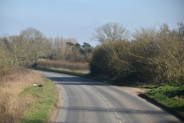
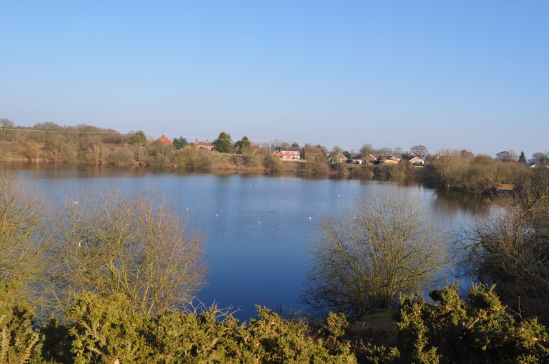
Benstead Marshes is a picturesque coastal marsh located in Suffolk, England. Situated near the village of Hollesley, it is a designated Area of Outstanding Natural Beauty (AONB) and is managed by the Suffolk Wildlife Trust. The marshes cover a vast area, stretching along the coastline for approximately 3 kilometers.

The landscape of Benstead Marshes is characterized by its unique blend of marshland and salt marsh habitats. The marshes are interlaced with a network of creeks and tidal channels, which are influenced by the ebb and flow of the nearby North Sea. As a result, the area is subject to regular tidal flooding, creating a dynamic and ever-changing environment.

The marshes are home to a diverse range of flora and fauna. The salt marshes are particularly important for their rich biodiversity, providing a habitat for a variety of plants and invertebrates that have adapted to the saline conditions. Common species found in the marshes include sea lavender, sea aster, and samphire.

In addition to its ecological importance, Benstead Marshes also serves as an important site for birdwatchers and nature enthusiasts. The marshes attract a wide range of bird species, including wading birds, ducks, and geese. During the winter months, the marshes become a haven for migratory birds, as they provide a crucial feeding and resting site.

Visitors to Benstead Marshes can enjoy a range of activities, including walking along the designated footpaths, birdwatching, and photography. The site offers stunning views of the surrounding landscape, with its open skies, expansive marshes, and the distant coastline. Overall, Benstead Marshes is a haven for wildlife and a tranquil retreat for those seeking to immerse themselves in the beauty of Suffolk's coastal marshlands.

If you have any feedback on the listing, please let us know in the comments section below.

Benstead Marshes Images

Images are sourced within 2km of 52.467881/1.4782063 or Grid Reference TM3691. Thanks to Geograph Open Source API. All images are credited.

Low Rd
Low Rd
The Anchorage, Low Rd
Entering Bungay, B1062 <span class="nowrap"><a title="https://www.sabre-roads.org.uk/wiki/index.php?title=B1062" rel="nofollow ugc noopener" href="https://www.sabre-roads.org.uk/wiki/index.php?title=B1062">Link</a><img style="margin-left:2px;" alt="External link" title="External link - shift click to open in new window" src="https://s1.geograph.org.uk/img/external.png" width="10" height="10"/></span>
Entering Bungay, B1062
Entering Mettingham, B1062 <span class="nowrap"><a title="https://www.sabre-roads.org.uk/wiki/index.php?title=B1062" rel="nofollow ugc noopener" href="https://www.sabre-roads.org.uk/wiki/index.php?title=B1062">Link</a><img style="margin-left:2px;" alt="External link" title="External link - shift click to open in new window" src="https://s1.geograph.org.uk/img/external.png" width="10" height="10"/></span>
Entering Mettingham, B1062
Homestead Farm
Homestead Farm
Homestead Farm
Homestead Farm
Beccles Rd <span class="nowrap"><a title="https://www.sabre-roads.org.uk/wiki/index.php?title=B1062" rel="nofollow ugc noopener" href="https://www.sabre-roads.org.uk/wiki/index.php?title=B1062">Link</a><img style="margin-left:2px;" alt="External link" title="External link - shift click to open in new window" src="https://s1.geograph.org.uk/img/external.png" width="10" height="10"/></span>
Beccles Rd
Watch House Hill <span class="nowrap"><a title="https://www.sabre-roads.org.uk/wiki/index.php?title=B1062" rel="nofollow ugc noopener" href="https://www.sabre-roads.org.uk/wiki/index.php?title=B1062">Link</a><img style="margin-left:2px;" alt="External link" title="External link - shift click to open in new window" src="https://s1.geograph.org.uk/img/external.png" width="10" height="10"/></span>
Watch House Hill
Vicarage Lane
Vicarage Lane
Mettingham Village sign Village signs are typically placed along the principal road or in a prominent location such as a village green or close by the church. The design often depicts a particularly feature of the village or a scene from its history, heritage, or culture. They are typically made of wood or metal or a combination of both, the designs are often made by the local community.
Although they do appear in villages and towns all over the country they are more prominent in East Anglia than elsewhere in the country.
Mettingham Village sign
Village signs are typically placed along the principal road or in a prominent location such as a village green or close by the church. The design often depicts a particularly feature of the village or a scene from its history, heritage, or culture. They are typically made of wood or metal or a combination of both, the designs are often made by the local community. Although they do appear in villages and towns all over the country they are more prominent in East Anglia than elsewhere in the country.
Entering Shipmeadow, B1062 <span class="nowrap"><a title="https://www.sabre-roads.org.uk/wiki/index.php?title=B1062" rel="nofollow ugc noopener" href="https://www.sabre-roads.org.uk/wiki/index.php?title=B1062">Link</a><img style="margin-left:2px;" alt="External link" title="External link - shift click to open in new window" src="https://s1.geograph.org.uk/img/external.png" width="10" height="10"/></span>
Entering Shipmeadow, B1062
Young crop field, Shipmeadow Looking towards Viewpoint Mews (the former Beccles and Bungay workhouse).
Young crop field, Shipmeadow
Looking towards Viewpoint Mews (the former Beccles and Bungay workhouse).
Heading west from Shipmeadow On the B1062.
Heading west from Shipmeadow
On the B1062.
Grazing, Shipmeadow Off the B1062.
Grazing, Shipmeadow
Off the B1062.
Show me another place!

Benstead Marshes is located at Grid Ref: TM3691 (Lat: 52.467881, Lng: 1.4782063)

Administrative County: Suffolk

District: East Suffolk

Police Authority: Suffolk

What 3 Words

///baked.buzzing.masts. Near Ditchingham, Norfolk

Nearby Locations

Benstead Marshes Ellingham

Related Wikis

Ellingham railway station

Ellingham is a former railway station in Ellingham, Norfolk. It was opened in 1863 as part of the Waveney Valley Line between Tivetshall and Beccles, Suffolk...

Ellingham, Norfolk

Ellingham is a village and civil parish in the English county of Norfolk. The village is located 2.3 miles (3.7 km) north-east of Bungay and 13 miles...

Mettingham

Mettingham is a village and civil parish in the north of the English county of Suffolk. It is 2 miles (3.2 km) east of the market town of Bungay in the...

Broome, Norfolk

Broome is a village and civil parish in the English county of Norfolk. It is situated on the north bank of the River Waveney, which forms the border with...

Broome Heath

Broome Heath is a 31.7-hectare (78-acre) Local Nature Reserve in Ditchingham in Norfolk. It is owned by South Norfolk District Council and managed by...

Broome Heath Pit

Broome Heath Pit is a 1.2-hectare (3.0-acre) geological Site of Special Scientific Interest east of Ditchingham in Norfolk. It is a Geological Conservation...

Ditchingham railway station

Ditchingham was a railway station in Ditchingham, Norfolk on the Waveney Valley Line. Opened on 2 March 1863, it closed to passengers along with the rest...
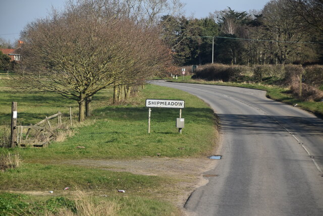
Shipmeadow

Shipmeadow is a village and civil parish located in the north of the English county of Suffolk. It is in the East Suffolk district, 2.5 miles (4.0 km)...

Nearby Amenities

Located within 500m of 52.467881,1.4782063
Waterway: weir
Lat/Long: 52.4712957/1.4797077
Waterway: weir
Lat/Long: 52.4715765/1.4791792
Power: pole
Lat/Long: 52.4719362/1.4753579
Power: pole
Lat/Long: 52.4712638/1.4740355
Power: pole
Lat/Long: 52.4706284/1.4728707
Waterway: weir
Lat/Long: 52.4718583/1.4799611
Marker: aerial
Utility: gas
Lat/Long: 52.4663625/1.4836333
The data included in this document is from www.openstreetmap.org. The data is made available under ODbL.

Have you been to Benstead Marshes?

Leave your review of Benstead Marshes below (or comments, questions and feedback).