Walton Marshes

Coastal Marsh, Saltings in Suffolk East Suffolk

England

Walton Marshes

World War One Memorial at Old Felixstowe The memorial bears 24 names from WW1. 17 on the main memorial and a further seven added at a later date on the lower plaque.
The WW2 Memorial is on the wall in the porch. <a title="https://www.geograph.org.uk/photo/4622642" href="https://www.geograph.org.uk/photo/4622642">Link</a>
World War One Memorial at Old Felixstowe Credit: Adrian S Pye

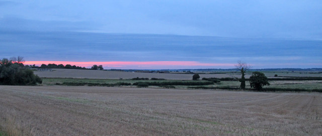
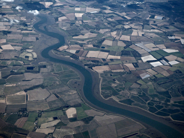
Walton Marshes in Suffolk is a coastal marshland area located near the town of Walton-on-the-Naze. The marshes are a designated Site of Special Scientific Interest (SSSI) due to their importance as a habitat for a variety of bird species and other wildlife.

The marshes are characterized by a mixture of salt marsh, mudflats, and tidal creeks, creating a diverse and ecologically rich environment. The area is home to a wide range of bird species, including wading birds such as avocets, redshanks, and dunlins, as well as wintering wildfowl like teal and wigeon.

Visitors to Walton Marshes can enjoy walking and birdwatching along the network of footpaths that crisscross the area. The marshes offer stunning views of the surrounding coastline and provide a peaceful and tranquil setting for nature lovers to explore.

The marshes are managed by the Essex Wildlife Trust, which works to conserve and protect this important habitat for future generations. Overall, Walton Marshes is a valuable and biodiverse nature reserve that offers a unique glimpse into the beauty of coastal marshlands in Suffolk.

If you have any feedback on the listing, please let us know in the comments section below.

Walton Marshes Images

Images are sourced within 2km of 51.98807/1.3656686 or Grid Reference TM3137. Thanks to Geograph Open Source API. All images are credited.

World War One Memorial at Old Felixstowe The memorial bears 24 names from WW1. 17 on the main memorial and a further seven added at a later date on the lower plaque.
The WW2 Memorial is on the wall in the porch. <a title="https://www.geograph.org.uk/photo/4622642" href="https://www.geograph.org.uk/photo/4622642">Link</a>
World War One Memorial at Old Felixstowe
The memorial bears 24 names from WW1. 17 on the main memorial and a further seven added at a later date on the lower plaque. The WW2 Memorial is on the wall in the porch. Link
Old Felixstowe WW2 Memorial The memorial with its 28 names is in the church porch.
the WW1 memorial is in the church. <a title="https://www.geograph.org.uk/photo/4622620" href="https://www.geograph.org.uk/photo/4622620">Link</a>
Old Felixstowe WW2 Memorial
The memorial with its 28 names is in the church porch. the WW1 memorial is in the church. Link
Sea wall and Martello Tower, Old Felixstowe The grassland to the left of the sea wall is a golf course.
Sea wall and Martello Tower, Old Felixstowe
The grassland to the left of the sea wall is a golf course.
Sundown over farmland, Old Felixstowe
Felixstowe Ferry from the air At the mouth of the River Deben. Viewed from a Stansted bound flight from Prague.
Felixstowe Ferry from the air
At the mouth of the River Deben. Viewed from a Stansted bound flight from Prague.
The River Deben from the air Looking over Lower Falkenhan from a Stansted bound flight from Prague.
The River Deben from the air
Looking over Lower Falkenhan from a Stansted bound flight from Prague.
Western View Across the River Deben Many small boats mooring close to the end of the river. Both sides of the river are quite rural at this ferry location. The river is narrow at about 200m at this point.

Wikipedia : <span class="nowrap"><a title="https://en.wikipedia.org/wiki/River_Deben" rel="nofollow ugc noopener" href="https://en.wikipedia.org/wiki/River_Deben">Link</a><img style="margin-left:2px;" alt="External link" title="External link - shift click to open in new window" src="https://s1.geograph.org.uk/img/external.png" width="10" height="10"/></span>
Western View Across the River Deben
Many small boats mooring close to the end of the river. Both sides of the river are quite rural at this ferry location. The river is narrow at about 200m at this point. Wikipedia : LinkExternal link
Riverside Houses near Bawdsey Manor
Dinghy sailing at Bawdsey Quay Looking across the river Deben from the balcony of the Boathouse Cafe.
Dinghy sailing at Bawdsey Quay
Looking across the river Deben from the balcony of the Boathouse Cafe.
High tide, Felixstowe Ferry Taken at the next high tide after a storm surge led to a severe flood warning for the area.
High tide, Felixstowe Ferry
Taken at the next high tide after a storm surge led to a severe flood warning for the area.
Bawdsey Ferry jetty The Bawdsey Ferry across the mouth of the River Deben is one of four small passenger ferries along the Suffolk coast. It forms a vital link for walkers following the Suffolk Coast Path and for cyclists on National Cycle Network Regional Route 41. The dates and times of operation are quite restricted.
Bawdsey Ferry jetty
The Bawdsey Ferry across the mouth of the River Deben is one of four small passenger ferries along the Suffolk coast. It forms a vital link for walkers following the Suffolk Coast Path and for cyclists on National Cycle Network Regional Route 41. The dates and times of operation are quite restricted.
The beach at Bawdsey Looking out to the mouth of the River Deben.
The beach at Bawdsey
Looking out to the mouth of the River Deben.
Under sail on the Deben Returning to Waldringfield on a fine August afternoon.
Under sail on the Deben
Returning to Waldringfield on a fine August afternoon.
Towards Felixstowe Ferry A somewhat foreshortened view against the light, taken from a boat anchored (for lunch) off Falkenham Marshes.
Towards Felixstowe Ferry
A somewhat foreshortened view against the light, taken from a boat anchored (for lunch) off Falkenham Marshes.
The mouth of the Deben Looking across the estuary towards Bawdsey from the shingle beach south of Felixstowe Ferry on the bright morning of Boxing Day.
The mouth of the Deben
Looking across the estuary towards Bawdsey from the shingle beach south of Felixstowe Ferry on the bright morning of Boxing Day.
Felixstowe Ferry: beach huts and Martello Tower The bright cold morning of Boxing Day 2017.
Felixstowe Ferry: beach huts and Martello Tower
The bright cold morning of Boxing Day 2017.
Seaside golf Teeing off next to a Martello Tower at Felixstowe Ferry Golf Club on the sunny morning of Boxing Day.
Seaside golf
Teeing off next to a Martello Tower at Felixstowe Ferry Golf Club on the sunny morning of Boxing Day.
Sunlight, shingle, sea and ship Looking out to sea from the path between Felixstowe Ferry (left) and Felixstowe on the bright morning of Boxing Day 2017.
Sunlight, shingle, sea and ship
Looking out to sea from the path between Felixstowe Ferry (left) and Felixstowe on the bright morning of Boxing Day 2017.
Show me another place!

Walton Marshes is located at Grid Ref: TM3137 (Lat: 51.98807, Lng: 1.3656686)

Administrative County: Suffolk

District: East Suffolk

Police Authority: Suffolk

What 3 Words

///soda.host.split. Near Felixstowe, Suffolk

Related Wikis

Felixstowe Ferry Golf Club

The Felixstowe Ferry Golf Club is in Felixstowe, Suffolk, England. == History == The club was founded in 1880. Francis Charteris, Lord Elcho, is considered...
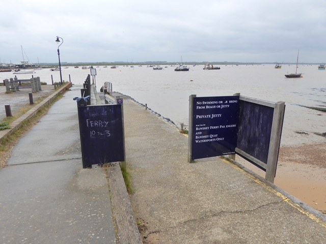
Felixstowe Ferry

Felixstowe Ferry is a hamlet in Suffolk, England, approximately two miles northeast of Felixstowe at the mouth of the River Deben with a ferry to the Bawdsey...

Falkenham

Falkenham is a village and a civil parish in the East Suffolk district, in the English county of Suffolk, near the village of Kirton and the towns of Ipswich...

River Deben

The River Deben is a river in Suffolk rising to the west of Debenham, though a second, higher source runs south from the parish of Bedingfield. The river...

Nearby Amenities

Located within 500m of 51.98807,1.3656686
Power: pole
Lat/Long: 51.9854797/1.3686775
Power: pole
Lat/Long: 51.9864297/1.3714945
Power: pole
Lat/Long: 51.9845596/1.3659148
Power: pole
Lat/Long: 51.9841004/1.3645201
Power: pole
Lat/Long: 51.9850106/1.3672694
Power: pole
Lat/Long: 51.9859522/1.3700723
Walton Marshes
Place: locality
Lat/Long: 51.9885868/1.3634577
The data included in this document is from www.openstreetmap.org. The data is made available under ODbL.

Have you been to Walton Marshes?

Leave your review of Walton Marshes below (or comments, questions and feedback).