Gashouse Point
Coastal Marsh, Saltings in Kent
England
Gashouse Point
![Upnor houses [1] Number 3 High Street, Upper Upnor, was built in the early 19th century. Constructed of yellow brick under a tile roof. Listed, grade II, with details at: <span class="nowrap"><a title="https://historicengland.org.uk/listing/the-list/list-entry/1085740" rel="nofollow ugc noopener" href="https://historicengland.org.uk/listing/the-list/list-entry/1085740">Link</a><img style="margin-left:2px;" alt="External link" title="External link - shift click to open in new window" src="https://s1.geograph.org.uk/img/external.png" width="10" height="10"/></span>
Upper Upnor and Lower Upnor are two small villages on the bank of the Medway River, some 1½ miles and 2 miles respectively northeast of Rochester. Upper Upnor is little more than a cobbled high street leading down to Upnor Castle, an Elizabethan artillery fort.](https://s0.geograph.org.uk/geophotos/07/07/36/7073624_9222e0ed.jpg)
Gashouse Point is a prominent coastal marsh and saltings area located in Kent, England. Situated along the southeastern coast of the county, this unique natural landscape stretches for approximately 2 miles and is a significant feature of the local environment.
The marshland is characterized by its vast expanse of salt marshes, tidal mudflats, and extensive reed beds. It is an important habitat for a diverse range of plant and animal species, including various wading birds, waterfowl, and insects. The area's ecological significance has led to its designation as a Site of Special Scientific Interest (SSSI), ensuring its protection and conservation for future generations.
Gashouse Point offers visitors a tranquil and scenic setting, with panoramic views of the marshes, the estuary, and the distant coastline. The landscape is ever-changing, influenced by the tides and weather patterns, providing a dynamic and captivating experience for nature enthusiasts and photographers.
Visitors can explore the area via designated footpaths and trails that wind through the marshes, offering opportunities for birdwatching, wildlife spotting, and enjoying the peaceful ambiance. The site is also a popular spot for nature walks, educational visits, and scientific research.
Access to Gashouse Point is facilitated by nearby parking facilities, and various amenities, such as information boards and picnic areas, are available to enhance visitors' experience. It is advisable to check tide times and weather conditions before planning a trip to fully appreciate the beauty and diversity of this coastal marsh and saltings area.
If you have any feedback on the listing, please let us know in the comments section below.
Gashouse Point Images
Images are sourced within 2km of 51.394045/0.50698015 or Grid Reference TQ7469. Thanks to Geograph Open Source API. All images are credited.
![Upnor houses [2] A delightfully eccentric house at number 7A High Street, Upper Upnor.
Upper Upnor and Lower Upnor are two small villages on the bank of the Medway River, some 1½ miles and 2 miles respectively northeast of Rochester. Upper Upnor is little more than a cobbled high street leading down to Upnor Castle, an Elizabethan artillery fort.](https://s2.geograph.org.uk/geophotos/07/07/36/7073626_aff411c2.jpg)
![Upnor houses [3] Castle House, number 19 High Street, seen here, and Albermarle Cottage, number 21 High Street <a href="https://www.geograph.org.uk/photo/7073630">TQ7570 : Upnor houses [4]</a>, are a pair of 17th century cottages. Number 19 has been greatly extended. Timber framed, number 19 weatherboarded, number 21 rendered ground floor, weatherboard above, all under a tile roof. Listed, grade II, with details at: <span class="nowrap"><a title="https://historicengland.org.uk/listing/the-list/list-entry/1336490" rel="nofollow ugc noopener" href="https://historicengland.org.uk/listing/the-list/list-entry/1336490">Link</a><img style="margin-left:2px;" alt="External link" title="External link - shift click to open in new window" src="https://s1.geograph.org.uk/img/external.png" width="10" height="10"/></span>
Upper Upnor and Lower Upnor are two small villages on the bank of the Medway River, some 1½ miles and 2 miles respectively northeast of Rochester. Upper Upnor is little more than a cobbled high street leading down to Upnor Castle, an Elizabethan artillery fort.](https://s1.geograph.org.uk/geophotos/07/07/36/7073629_c6e9ecd9.jpg)
![Upnor houses [4] Albermarle Cottage, number 21 High Street, seen here and Castle House, number 19 High Street, <a href="https://www.geograph.org.uk/photo/7073629">TQ7570 : Upnor houses [3]</a>, are a pair of 17th century cottages. Number 19 has been greatly extended. Timber framed, number 19 weatherboarded, number 21 rendered ground floor, weatherboard above, all under a tile roof. Listed, grade II, with details at: <span class="nowrap"><a title="https://historicengland.org.uk/listing/the-list/list-entry/1336490" rel="nofollow ugc noopener" href="https://historicengland.org.uk/listing/the-list/list-entry/1336490">Link</a><img style="margin-left:2px;" alt="External link" title="External link - shift click to open in new window" src="https://s1.geograph.org.uk/img/external.png" width="10" height="10"/></span>
Upper Upnor and Lower Upnor are two small villages on the bank of the Medway River, some 1½ miles and 2 miles respectively northeast of Rochester. Upper Upnor is little more than a cobbled high street leading down to Upnor Castle, an Elizabethan artillery fort.](https://s2.geograph.org.uk/geophotos/07/07/36/7073630_d582d622.jpg)
![Upnor buildings [1] The Tudor Rose public house, number 29 High Street, Upper Upnor, is in two builds. The nearest part is late 17th or early 18th century, the further part and the projecting entrance is 19th century. Constructed of rendered brick with a mix of tile and slate roofs. Some internal late Georgian fittings remain. Listed, grade II, with details at: <span class="nowrap"><a title="https://historicengland.org.uk/listing/the-list/list-entry/1390628" rel="nofollow ugc noopener" href="https://historicengland.org.uk/listing/the-list/list-entry/1390628">Link</a><img style="margin-left:2px;" alt="External link" title="External link - shift click to open in new window" src="https://s1.geograph.org.uk/img/external.png" width="10" height="10"/></span>
Upper Upnor and Lower Upnor are two small villages on the bank of the Medway River, some 1½ miles and 2 miles respectively northeast of Rochester. Upper Upnor is little more than a cobbled high street leading down to Upnor Castle, an Elizabethan artillery fort.](https://s0.geograph.org.uk/geophotos/07/07/44/7074440_54221b5e.jpg)
![Upnor houses [5] Numbers 30 and 32 High Street, Upper Upnor, are a pair of 17th century cottages, now combined into one. Timber framed and weatherboarded with some rendering on the first floor, all under a tile roof. Listed, grade II, with details at: <span class="nowrap"><a title="https://historicengland.org.uk/listing/the-list/list-entry/1085743" rel="nofollow ugc noopener" href="https://historicengland.org.uk/listing/the-list/list-entry/1085743">Link</a><img style="margin-left:2px;" alt="External link" title="External link - shift click to open in new window" src="https://s1.geograph.org.uk/img/external.png" width="10" height="10"/></span>
Upper Upnor and Lower Upnor are two small villages on the bank of the Medway River, some 1½ miles and 2 miles respectively northeast of Rochester. Upper Upnor is little more than a cobbled high street leading down to Upnor Castle, an Elizabethan artillery fort.](https://s1.geograph.org.uk/geophotos/07/07/44/7074441_4bcc2a66.jpg)
![Upnor houses [6] This row of cottages, even numbers 12 to 18, High Street, were built in the mid 18th century. Constructed of weatherboarded brick under a tiled mansard roof. Listed, grade II, with details at: <span class="nowrap"><a title="https://historicengland.org.uk/listing/the-list/list-entry/1336491" rel="nofollow ugc noopener" href="https://historicengland.org.uk/listing/the-list/list-entry/1336491">Link</a><img style="margin-left:2px;" alt="External link" title="External link - shift click to open in new window" src="https://s1.geograph.org.uk/img/external.png" width="10" height="10"/></span>
Upper Upnor and Lower Upnor are two small villages on the bank of the Medway River, some 1½ miles and 2 miles respectively northeast of Rochester. Upper Upnor is little more than a cobbled high street leading down to Upnor Castle, an Elizabethan artillery fort.](https://s2.geograph.org.uk/geophotos/07/07/44/7074442_74e6d169.jpg)
![Upnor features [1] At the bottom of the High Street in Upper Upnor is this delightful lookout with a fine view over the River Medway.
Upper Upnor and Lower Upnor are two small villages on the bank of the Medway River, some 1½ miles and 2 miles respectively northeast of Rochester. Upper Upnor is little more than a cobbled high street leading down to Upnor Castle, an Elizabethan artillery fort.](https://s3.geograph.org.uk/geophotos/07/07/44/7074443_4d4799ca.jpg)
![Upnor features [2] At the bottom of the High Street, Upper Upnor, on the bank of the River Medway, is this fine topograph.
Upper Upnor and Lower Upnor are two small villages on the bank of the Medway River, some 1½ miles and 2 miles respectively northeast of Rochester. Upper Upnor is little more than a cobbled high street leading down to Upnor Castle, an Elizabethan artillery fort.](https://s0.geograph.org.uk/geophotos/07/07/44/7074444_053d427b.jpg)
![Upnor Castle [1] An information board near the entrance to the castle.
Upnor Castle is an Elizabethan artillery fort intended to protect Chatham Dockyard and ships of the Royal Navy anchored in the Medway. It was constructed between 1559–67 on the orders of Elizabeth I. Neglected in the 17th century and, when the Dutch raided in 1667, the fort was replaced by stronger defences downriver and became a gunpowder store. It remained in military use until 1945 and is now in the care of English Heritage and open to the public. Listed, grade I, with details at: <span class="nowrap"><a title="https://historicengland.org.uk/listing/the-list/list-entry/1204365" rel="nofollow ugc noopener" href="https://historicengland.org.uk/listing/the-list/list-entry/1204365">Link</a><img style="margin-left:2px;" alt="External link" title="External link - shift click to open in new window" src="https://s1.geograph.org.uk/img/external.png" width="10" height="10"/></span> A Scheduled Ancient Monument with details at: <span class="nowrap"><a title="https://historicengland.org.uk/listing/the-list/list-entry/1012980" rel="nofollow ugc noopener" href="https://historicengland.org.uk/listing/the-list/list-entry/1012980">Link</a><img style="margin-left:2px;" alt="External link" title="External link - shift click to open in new window" src="https://s1.geograph.org.uk/img/external.png" width="10" height="10"/></span>](https://s1.geograph.org.uk/geophotos/07/07/44/7074445_2ad383f4.jpg)
![Upnor Castle [2] The gatehouse to the inner fort.
Upnor Castle is an Elizabethan artillery fort intended to protect Chatham Dockyard and ships of the Royal Navy anchored in the Medway. It was constructed between 1559–67 on the orders of Elizabeth I. Neglected in the 17th century and, when the Dutch raided in 1667, the fort was replaced by stronger defences downriver and became a gunpowder store. It remained in military use until 1945 and is now in the care of English Heritage and open to the public. Listed, grade I, with details at: <span class="nowrap"><a title="https://historicengland.org.uk/listing/the-list/list-entry/1204365" rel="nofollow ugc noopener" href="https://historicengland.org.uk/listing/the-list/list-entry/1204365">Link</a><img style="margin-left:2px;" alt="External link" title="External link - shift click to open in new window" src="https://s1.geograph.org.uk/img/external.png" width="10" height="10"/></span> A Scheduled Ancient Monument with details at: <span class="nowrap"><a title="https://historicengland.org.uk/listing/the-list/list-entry/1012980" rel="nofollow ugc noopener" href="https://historicengland.org.uk/listing/the-list/list-entry/1012980">Link</a><img style="margin-left:2px;" alt="External link" title="External link - shift click to open in new window" src="https://s1.geograph.org.uk/img/external.png" width="10" height="10"/></span>](https://s2.geograph.org.uk/geophotos/07/07/44/7074446_76273b5f.jpg)
![Upnor Castle [3] The gatehouse of the fort.
Upnor Castle is an Elizabethan artillery fort intended to protect Chatham Dockyard and ships of the Royal Navy anchored in the Medway. It was constructed between 1559–67 on the orders of Elizabeth I. Neglected in the 17th century and, when the Dutch raided in 1667, the fort was replaced by stronger defences downriver and became a gunpowder store. It remained in military use until 1945 and is now in the care of English Heritage and open to the public. Listed, grade I, with details at: <span class="nowrap"><a title="https://historicengland.org.uk/listing/the-list/list-entry/1204365" rel="nofollow ugc noopener" href="https://historicengland.org.uk/listing/the-list/list-entry/1204365">Link</a><img style="margin-left:2px;" alt="External link" title="External link - shift click to open in new window" src="https://s1.geograph.org.uk/img/external.png" width="10" height="10"/></span> A Scheduled Ancient Monument with details at: <span class="nowrap"><a title="https://historicengland.org.uk/listing/the-list/list-entry/1012980" rel="nofollow ugc noopener" href="https://historicengland.org.uk/listing/the-list/list-entry/1012980">Link</a><img style="margin-left:2px;" alt="External link" title="External link - shift click to open in new window" src="https://s1.geograph.org.uk/img/external.png" width="10" height="10"/></span>](https://s3.geograph.org.uk/geophotos/07/07/44/7074447_0ae557e2.jpg)
![Upnor Castle [4] Inside the fort.
Upnor Castle is an Elizabethan artillery fort intended to protect Chatham Dockyard and ships of the Royal Navy anchored in the Medway. It was constructed between 1559–67 on the orders of Elizabeth I. Neglected in the 17th century and, when the Dutch raided in 1667, the fort was replaced by stronger defences downriver and became a gunpowder store. It remained in military use until 1945 and is now in the care of English Heritage and open to the public. Listed, grade I, with details at: <span class="nowrap"><a title="https://historicengland.org.uk/listing/the-list/list-entry/1204365" rel="nofollow ugc noopener" href="https://historicengland.org.uk/listing/the-list/list-entry/1204365">Link</a><img style="margin-left:2px;" alt="External link" title="External link - shift click to open in new window" src="https://s1.geograph.org.uk/img/external.png" width="10" height="10"/></span> A Scheduled Ancient Monument with details at: <span class="nowrap"><a title="https://historicengland.org.uk/listing/the-list/list-entry/1012980" rel="nofollow ugc noopener" href="https://historicengland.org.uk/listing/the-list/list-entry/1012980">Link</a><img style="margin-left:2px;" alt="External link" title="External link - shift click to open in new window" src="https://s1.geograph.org.uk/img/external.png" width="10" height="10"/></span>](https://s0.geograph.org.uk/geophotos/07/07/44/7074448_59ca027f.jpg)
![Upnor Castle [5] Inside the fort.
Upnor Castle is an Elizabethan artillery fort intended to protect Chatham Dockyard and ships of the Royal Navy anchored in the Medway. It was constructed between 1559–67 on the orders of Elizabeth I. Neglected in the 17th century and, when the Dutch raided in 1667, the fort was replaced by stronger defences downriver and became a gunpowder store. It remained in military use until 1945 and is now in the care of English Heritage and open to the public. Listed, grade I, with details at: <span class="nowrap"><a title="https://historicengland.org.uk/listing/the-list/list-entry/1204365" rel="nofollow ugc noopener" href="https://historicengland.org.uk/listing/the-list/list-entry/1204365">Link</a><img style="margin-left:2px;" alt="External link" title="External link - shift click to open in new window" src="https://s1.geograph.org.uk/img/external.png" width="10" height="10"/></span> A Scheduled Ancient Monument with details at: <span class="nowrap"><a title="https://historicengland.org.uk/listing/the-list/list-entry/1012980" rel="nofollow ugc noopener" href="https://historicengland.org.uk/listing/the-list/list-entry/1012980">Link</a><img style="margin-left:2px;" alt="External link" title="External link - shift click to open in new window" src="https://s1.geograph.org.uk/img/external.png" width="10" height="10"/></span>](https://s1.geograph.org.uk/geophotos/07/07/44/7074449_c7535126.jpg)
![Upnor Castle [9] The view from the fort of the River Medway looking upstream. The buildings of Chatham Dockyard are prominent on the opposite bank.
Upnor Castle is an Elizabethan artillery fort intended to protect Chatham Dockyard and ships of the Royal Navy anchored in the Medway. It was constructed between 1559–67 on the orders of Elizabeth I. Neglected in the 17th century and, when the Dutch raided in 1667, the fort was replaced by stronger defences downriver and became a gunpowder store. It remained in military use until 1945 and is now in the care of English Heritage and open to the public. Listed, grade I, with details at: <span class="nowrap"><a title="https://historicengland.org.uk/listing/the-list/list-entry/1204365" rel="nofollow ugc noopener" href="https://historicengland.org.uk/listing/the-list/list-entry/1204365">Link</a><img style="margin-left:2px;" alt="External link" title="External link - shift click to open in new window" src="https://s1.geograph.org.uk/img/external.png" width="10" height="10"/></span> A Scheduled Ancient Monument with details at: <span class="nowrap"><a title="https://historicengland.org.uk/listing/the-list/list-entry/1012980" rel="nofollow ugc noopener" href="https://historicengland.org.uk/listing/the-list/list-entry/1012980">Link</a><img style="margin-left:2px;" alt="External link" title="External link - shift click to open in new window" src="https://s1.geograph.org.uk/img/external.png" width="10" height="10"/></span>](https://s0.geograph.org.uk/geophotos/07/07/44/7074456_2da4affa.jpg)


Gashouse Point is located at Grid Ref: TQ7469 (Lat: 51.394045, Lng: 0.50698015)
Unitary Authority: Medway
Police Authority: Kent
What 3 Words
///humans.years.picked. Near Rochester, Kent
Nearby Locations
Related Wikis
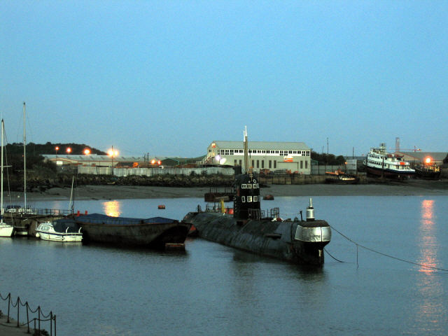
Submarine U-475 Black Widow
Submarine U-475 Black Widow was a Soviet Navy submarine of the Cold war period, which is now in private hands. It is currently moored at Strood, on the...

Rochester Common railway station
Rochester Common was a station on the Chatham Extension from Strood serving the town of Rochester. The station was opened by the South Eastern Railway...
Strood (1st) railway station
Strood (1st) (locally known as and marked on old maps as The Old Terminus) was a terminus of the South Eastern Railway located in Strood and serving also...
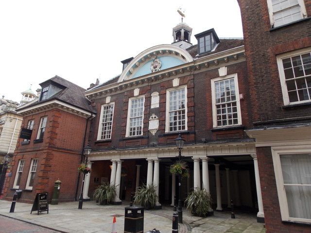
Rochester Guildhall
The Rochester Guildhall is an historic building located in the High Street in Rochester, Kent, England. It is a Grade I listed building. == History... ==
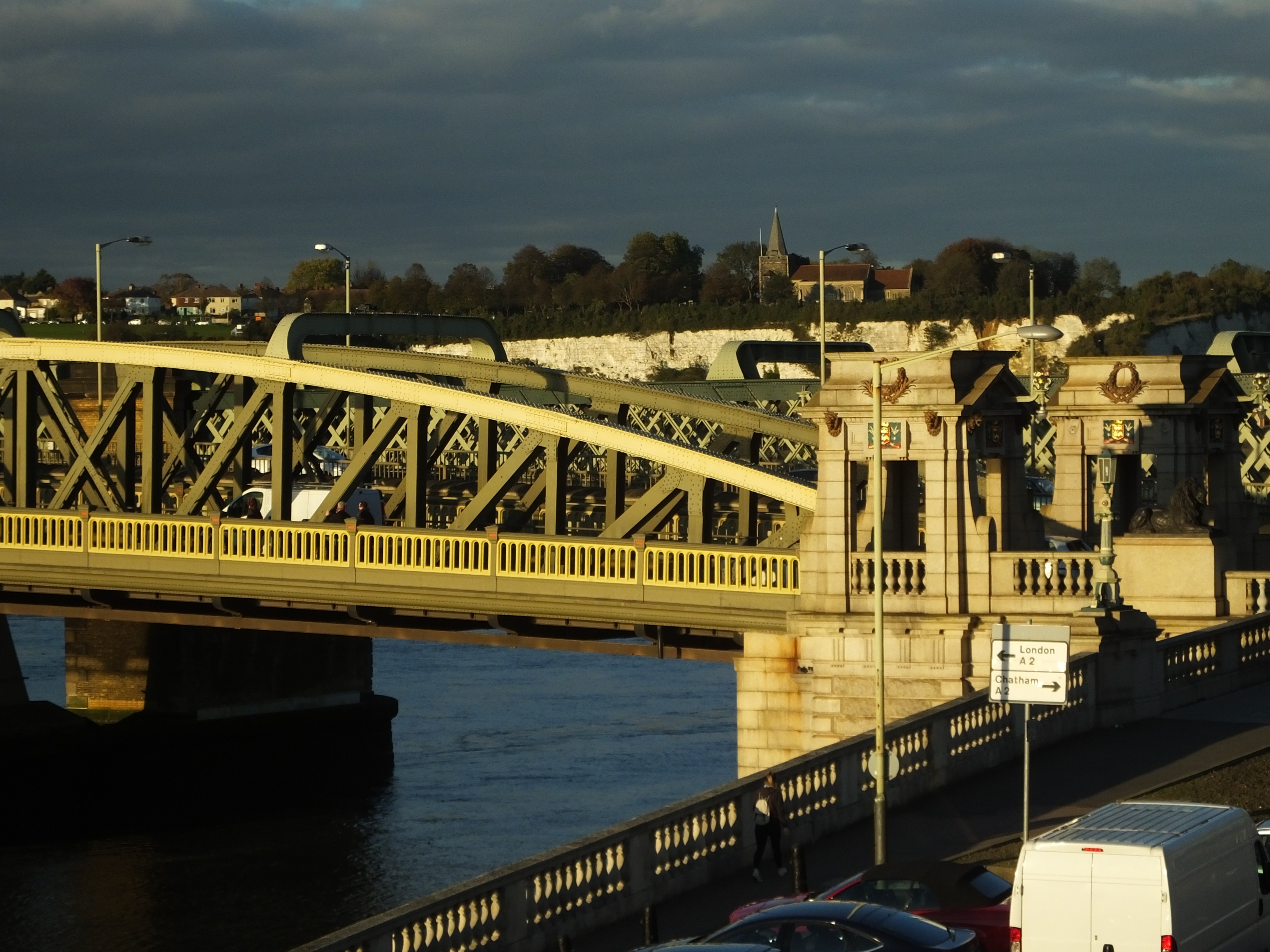
Rochester Bridge
Rochester Bridge in Rochester, Medway was for centuries the lowest fixed crossing of the River Medway in South East England. There have been several generations...
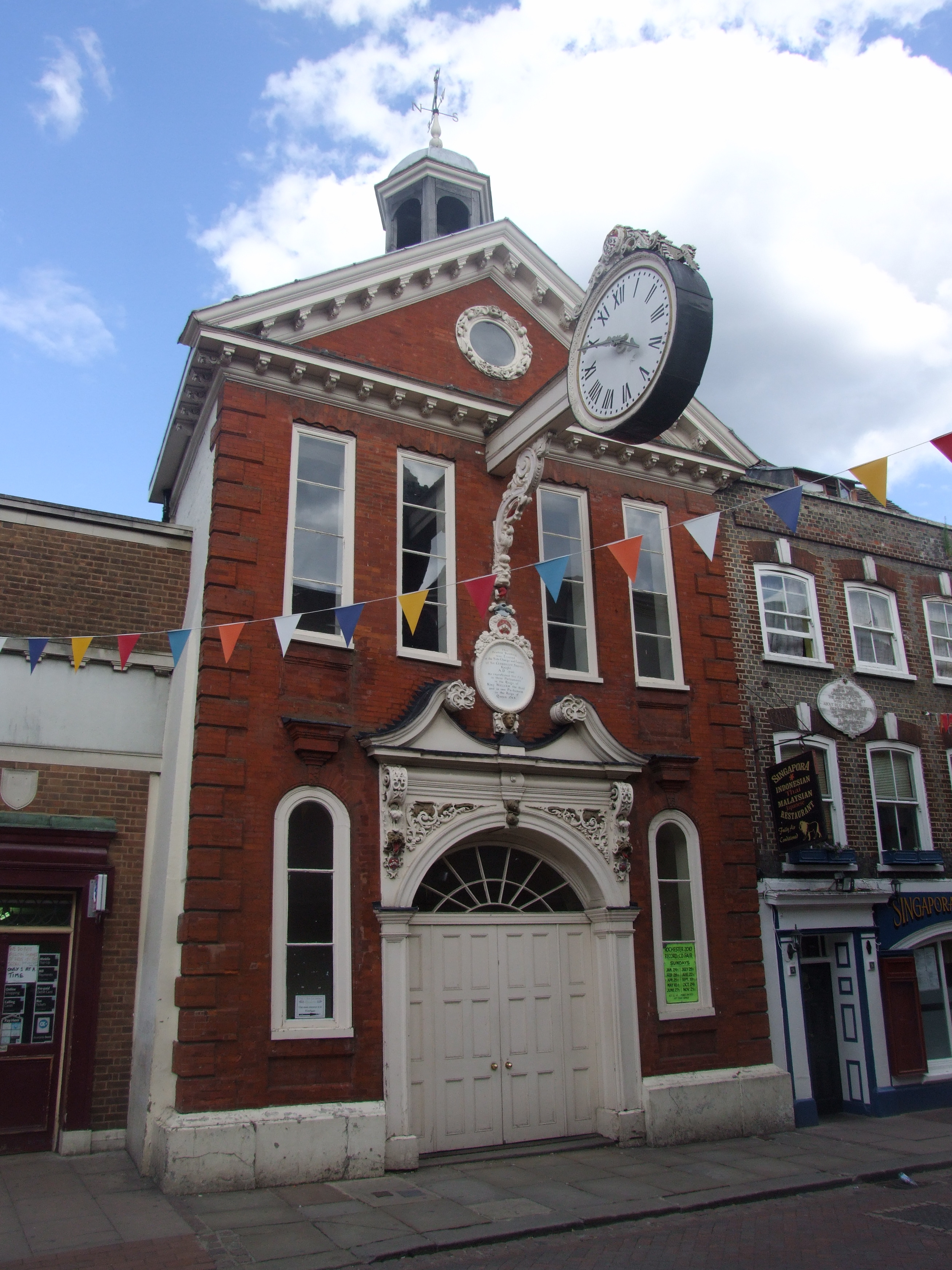
Corn Exchange, Rochester
The Corn Exchange is a commercial complex in the High Street, Rochester, Kent, England. The complex, which was commissioned as a corn exchange and is now...
Strood railway station
Strood railway station serves the town of Strood in Medway, England. It is on the North Kent Line and is also a terminus of the Medway Valley Line. It...

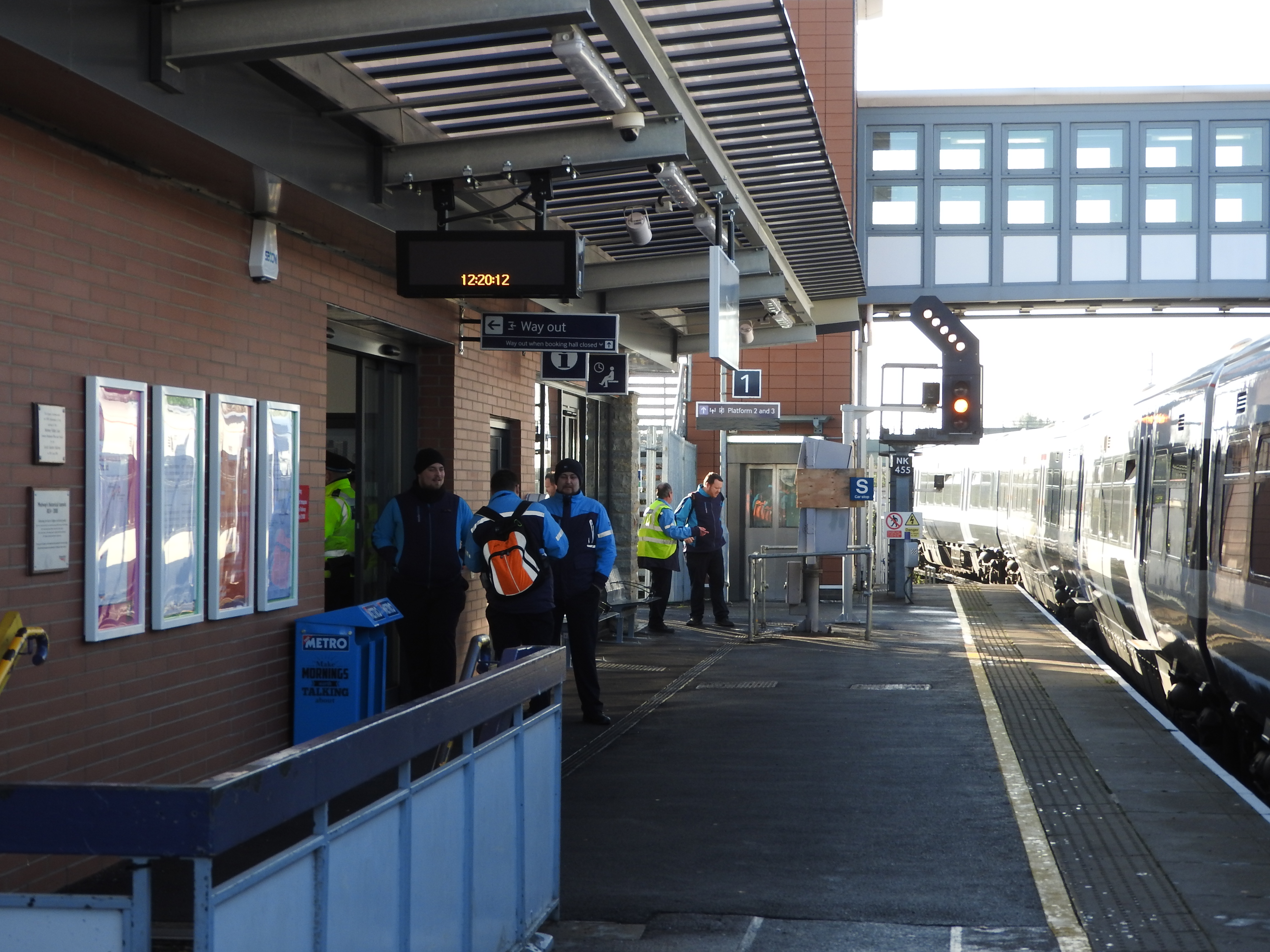
Rochester railway station
Rochester railway station is on the Chatham Main Line in England, serving the town of Rochester, Kent. It is 33 miles 61 chains (54.3 km) down the line...
Nearby Amenities
Located within 500m of 51.394045,0.50698015Have you been to Gashouse Point?
Leave your review of Gashouse Point below (or comments, questions and feedback).