Longdyke Scar

Coastal Marsh, Saltings in Cumberland Allerdale

England

Longdyke Scar

Moricambe Bay The seaweed covered shingle at the extreme end of Grune Point, a sand and shingle spit extending north eastwards into Moricambe Bay, the estuary of the Rivers Wampool and Waver. In the background beyond the waters of Moricambe Bay are the masts of Anthorn Radio Station, location of the three National Physical Laboratory atomic clocks.
Moricambe Bay Credit: Adrian Taylor

Longdyke Scar is a picturesque coastal feature located in Cumberland, England. It is a prominent and well-known scar that stretches along the coast, offering breathtaking views of the surrounding landscape. This natural wonder is situated on the edge of a coastal marsh and is often referred to as the Coastal Marsh or Saltings.

Longdyke Scar rises majestically from the marshland, forming a long and narrow ridge that runs parallel to the coastline. The scar is made up of layers of sedimentary rock, which have been eroded over time by the forces of wind and water, creating its distinctive shape. The exposed rocks showcase a variety of colors, ranging from shades of brown to grey, adding to the scenic beauty of the area.

The Coastal Marsh surrounding Longdyke Scar is a unique ecosystem that supports a diverse range of plant and animal species. The marshland is characterized by its rich biodiversity, with an abundance of salt-tolerant plants, such as samphire and sea lavender. These plants provide important habitats for various bird species, including waders and waterfowl, which can often be spotted foraging in the marshes.

Visitors to Longdyke Scar can enjoy a leisurely walk along the ridge, taking in the stunning panoramic views of the surrounding countryside and coastline. The area is also popular with birdwatchers and nature enthusiasts, who flock to witness the incredible array of wildlife that calls this coastal marsh home.

In conclusion, Longdyke Scar in Cumberland is a captivating natural formation that offers a unique blend of geological beauty and diverse ecosystems. It is a must-visit destination for those seeking solace in the tranquility of nature and the awe-inspiring wonders it has to offer.

If you have any feedback on the listing, please let us know in the comments section below.

Longdyke Scar Images

Images are sourced within 2km of 54.907371/-3.2976823 or Grid Reference NY1657. Thanks to Geograph Open Source API. All images are credited.

Moricambe Bay The seaweed covered shingle at the extreme end of Grune Point, a sand and shingle spit extending north eastwards into Moricambe Bay, the estuary of the Rivers Wampool and Waver. In the background beyond the waters of Moricambe Bay are the masts of Anthorn Radio Station, location of the three National Physical Laboratory atomic clocks.
Moricambe Bay
The seaweed covered shingle at the extreme end of Grune Point, a sand and shingle spit extending north eastwards into Moricambe Bay, the estuary of the Rivers Wampool and Waver. In the background beyond the waters of Moricambe Bay are the masts of Anthorn Radio Station, location of the three National Physical Laboratory atomic clocks.
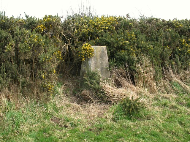
Triangulation Pillar, Cardurnock The concrete Ordnance Survey triangulation pillar beside a gorse hedge at Cardurnock.
The pillar was constructed in 1952. The flush bracket benchmark number S6939 on the west southwest face of the pillar marks a height of 18.9558m above mean sea level (Ordnance Datum Newlyn) last levelled for height in 1971 (detail photograph <a href="https://www.geograph.org.uk/photo/7340151">NY1759 : Benchmark, Cardurnock</a>).
Triangulation Pillar, Cardurnock
The concrete Ordnance Survey triangulation pillar beside a gorse hedge at Cardurnock. The pillar was constructed in 1952. The flush bracket benchmark number S6939 on the west southwest face of the pillar marks a height of 18.9558m above mean sea level (Ordnance Datum Newlyn) last levelled for height in 1971 (detail photograph NY1759 : Benchmark, Cardurnock).
Benchmark, Cardurnock Detail of the flush bracket benchmark on the Ordnance Survey triangulation pillar at Cardurnock. The flush bracket, benchmark number S6938, is on the west southwest face of the pillar and marks a height of 18.9558m above mean sea level (Ordnance Datum Newlyn), last levelled for height in 1971 (location photograph <a href="https://www.geograph.org.uk/photo/7340098">NY1759 : Triangulation Pillar, Cardurnock</a>).
Benchmark, Cardurnock
Detail of the flush bracket benchmark on the Ordnance Survey triangulation pillar at Cardurnock. The flush bracket, benchmark number S6938, is on the west southwest face of the pillar and marks a height of 18.9558m above mean sea level (Ordnance Datum Newlyn), last levelled for height in 1971 (location photograph NY1759 : Triangulation Pillar, Cardurnock).
The entrance to North End Farm
Buildings in Cardurnock
Radio masts and disused airfield
An anchor point for one of the radio masts
The radio masts near Anthorn
RNAS Anthorn Test-Firing Butt One of a number of test butts beside the coastal road.  A flagpole can be noted at the top right of the building.  For further information on RNAS Anthorn, refer to <span class="nowrap"><a title="http://www.users.globalnet.co.uk/~rwbarnes/defence/nuthatch.htm#butts" rel="nofollow ugc noopener" href="http://www.users.globalnet.co.uk/~rwbarnes/defence/nuthatch.htm#butts">Link</a><img style="margin-left:2px;" alt="External link" title="External link - shift click to open in new window" src="https://s1.geograph.org.uk/img/external.png" width="10" height="10"/></span>
RNAS Anthorn Test-Firing Butt
One of a number of test butts beside the coastal road. A flagpole can be noted at the top right of the building. For further information on RNAS Anthorn, refer to LinkExternal link
Anthorn Radio Station - Image #1 A view of the main transmitter and associated buildings.
Anthorn Radio Station - Image #1
A view of the main transmitter and associated buildings.
Anthorn Radio Station - Image #2 Guy cable detail beside the coastal road.
Anthorn Radio Station - Image #2
Guy cable detail beside the coastal road.
Anthorn Radio Station - Image #3 Mast detail at Anthorn.
Anthorn Radio Station - Image #3
Mast detail at Anthorn.
Anthorn Radio Station - Image #4 Insulator and antenna detail at Anthorn.
Anthorn Radio Station - Image #4
Insulator and antenna detail at Anthorn.
Anthorn Radio Station - Image #5 Insulator detail at Anthorn.
Anthorn Radio Station - Image #5
Insulator detail at Anthorn.
The Anthorn Radio Station
The shore at Moricambe The nearby channel is that of the River Wampool. The further channel, perhaps easier to see on the photo, is that of the River Waver.
The shore at Moricambe
The nearby channel is that of the River Wampool. The further channel, perhaps easier to see on the photo, is that of the River Waver.
Anthorn Transmitting Station
Field and Hedge Line viewed from the Cardurnock Triangulation Pillar Looking north-westward.
Field and Hedge Line viewed from the Cardurnock Triangulation Pillar
Looking north-westward.
Show me another place!

Longdyke Scar is located at Grid Ref: NY1657 (Lat: 54.907371, Lng: -3.2976823)

Administrative County: Cumbria

District: Allerdale

Police Authority: Cumbria

What 3 Words

///glorious.foresight.hopeless. Near Silloth, Cumbria

Nearby Locations

Longdyke Scar

Related Wikis

Cardurnock

Cardurnock is a small settlement in Cumbria, England. It is by the coast, 20 kilometres (12 mi) west of Carlisle. The western extension of the Hadrian...

Milefortlet 5

Milefortlet 5 (Cardurnock) was a Milefortlet of the Roman Cumbrian Coast defences. These milefortlets and intervening stone watchtowers extended from...

Moricambe Bay

Moricambe Bay is an inlet of the Solway Firth in Cumbria (before 1974 in Cumberland) in north west England, created by the confluence of two rivers, the...

Time from NPL (MSF)

The Time from NPL is a radio signal broadcast from the Anthorn Radio Station near Anthorn, Cumbria, which serves as the United Kingdom's national time...

Nearby Amenities

Located within 500m of 54.907371,-3.2976823
Created By: almien_coastlines
Source: PGS
Lat/Long: 54.9113298/-3.3011986
Created By: almien_coastlines
Source: PGS
Lat/Long: 54.9111238/-3.3009166
Source: PGS
Lat/Long: 54.9109706/-3.300711
Created By: almien_coastlines
Source: PGS
Lat/Long: 54.9106655/-3.300117
Source: PGS
Lat/Long: 54.9104113/-3.2995829
Source: PGS
Lat/Long: 54.9102066/-3.2989888
Created By: almien_coastlines
Source: PGS
Lat/Long: 54.9099353/-3.2984116
Created By: almien_coastlines
Source: PGS
Lat/Long: 54.9097067/-3.2981797
Created By: almien_coastlines
Source: PGS
Lat/Long: 54.9095787/-3.2979164
Source: PGS
Lat/Long: 54.9092071/-3.2977483
Created By: almien_coastlines
Source: PGS
Lat/Long: 54.9085106/-3.2973779
Created By: almien_coastlines
Source: PGS
Lat/Long: 54.9079347/-3.2973061
Created By: almien_coastlines
Source: PGS
Lat/Long: 54.9076789/-3.2966875
Created By: almien_coastlines
Source: PGS
Lat/Long: 54.9074041/-3.2958778
Created By: almien_coastlines
Source: PGS
Lat/Long: 54.9072281/-3.2949632
Created By: almien_coastlines
Source: PGS
Lat/Long: 54.9071708/-3.2939653
Created By: almien_coastlines
Source: PGS
Lat/Long: 54.9072622/-3.2935006
Created By: almien_coastlines
Source: PGS
Lat/Long: 54.9071749/-3.2925841
Created By: almien_coastlines
Source: PGS
Lat/Long: 54.9069113/-3.2920654
Created By: almien_coastlines
Source: PGS
Lat/Long: 54.9066121/-3.2915674
Created By: almien_coastlines
Source: PGS
Lat/Long: 54.906216/-3.2905988
The data included in this document is from www.openstreetmap.org. The data is made available under ODbL.

Have you been to Longdyke Scar?

Leave your review of Longdyke Scar below (or comments, questions and feedback).