Arch Zawn

Coastal Marsh, Saltings in Cornwall

England

Arch Zawn

Views out to sea from PROW
Views out to sea from PROW Credit: thejackrustles

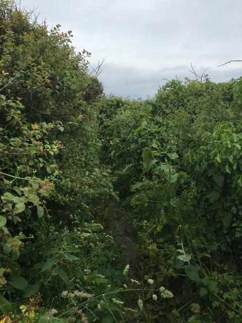
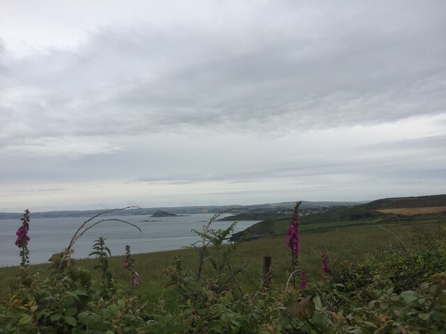
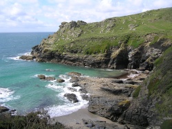
Arch Zawn is a stunning coastal marsh located in Cornwall, England. Known for its picturesque beauty, it is situated on the rugged coastline, nestled between towering cliffs and the vast expanse of the Atlantic Ocean. The name "zawn" refers to a deep, narrow inlet or gorge, which perfectly describes the geological formation of this remarkable site.

The marsh is predominantly characterized by its saltwater environment, owing to the regular influx of seawater during high tides. This unique ecosystem, known as a coastal salting, supports a diverse range of plant and animal species that have adapted to the harsh conditions. The vegetation consists of salt-tolerant plants such as sea lavender, sea aster, and samphire, which create a vibrant and colorful landscape during the summer months.

Arch Zawn is also home to a rich variety of birdlife, making it a popular spot for birdwatching enthusiasts. Species such as oystercatchers, curlews, and sandpipers can be spotted scavenging for food along the marsh's muddy banks. Additionally, the cliffs surrounding the zawn provide ideal nesting sites for seabirds like fulmars and kittiwakes.

Visitors to Arch Zawn can enjoy breathtaking views of the rugged coastline, particularly from the top of the cliffs. The area is accessible via a footpath that winds its way through the marsh, offering an immersive experience of the unique coastal environment. The marsh also provides an opportunity to witness the powerful forces of nature at work, as the tides ebb and flow, shaping the landscape and creating tidal pools that teem with marine life.

Overall, Arch Zawn is a captivating natural wonder, showcasing the beauty and resilience of coastal ecosystems. Its diverse flora and fauna, coupled with its dramatic scenery, make it a must-visit destination for nature lovers and outdoor enthusiasts alike.

If you have any feedback on the listing, please let us know in the comments section below.

Arch Zawn Images

Images are sourced within 2km of 50.100766/-5.4272573 or Grid Reference SW5527. Thanks to Geograph Open Source API. All images are credited.

Views out to sea from PROW
Very overgrown footpath
Lovely coastline
Lovely coastline
Cudden Point Trig Point Flush Bracket S8075 <span class="nowrap"><a title="http://trigpointing.uk/trig/2667" rel="nofollow ugc noopener" href="http://trigpointing.uk/trig/2667">Link</a><img style="margin-left:2px;" alt="External link" title="External link - shift click to open in new window" src="https://s1.geograph.org.uk/img/external.png" width="10" height="10"/></span>
Cudden Point Trig Point Flush Bracket S8075
Coastal views
Coastal views
Prussia Cove
Prussia Cove
Looking down on Kenneggy Sand
Looking along Kenneggy Cliff  From the old mine.
Looking along Kenneggy Cliff
From the old mine.
The old mine above Kenneggy Sand
The footpath near the old mine
Farm tracks and footpaths A complicated junction on the way to the Coast Path.
Farm tracks and footpaths
A complicated junction on the way to the Coast Path.
The entrance to Higher Kenneggy wild camping site
Higher Kenneggy wild campsite Very few facilities, if not exactly 'wild'.
Higher Kenneggy wild campsite
Very few facilities, if not exactly 'wild'.
Coastal rocks near Pestreath Cove
The Coast Path near Pestreath Cove The path just passes through the corner of this square.
The Coast Path near Pestreath Cove
The path just passes through the corner of this square.
Former Wesleyan Chapel Built in 1858. Closed 1980 and converted into a studio and dwelling <span class="nowrap"><a title="http://cornishstory.com/2021/09/22/mapping-methodism-perranuthnoe-wesleyan-chapel/" rel="nofollow ugc noopener" href="http://cornishstory.com/2021/09/22/mapping-methodism-perranuthnoe-wesleyan-chapel/">Link</a><img style="margin-left:2px;" alt="External link" title="External link - shift click to open in new window" src="https://s1.geograph.org.uk/img/external.png" width="10" height="10"/></span>
Former Wesleyan Chapel
Built in 1858. Closed 1980 and converted into a studio and dwelling LinkExternal link
Former Bible Christian chapel
Former Wesleyan Methodist Chapel
Show me another place!

Arch Zawn is located at Grid Ref: SW5527 (Lat: 50.100766, Lng: -5.4272573)

Unitary Authority: Cornwall

Police Authority: Devon and Cornwall

What 3 Words

///twisty.reforming.barefoot. Near Germoe, Cornwall

Related Wikis

Acton Castle

Acton Castle is a small castellated mansion near Perranuthnoe, Cornwall. It is a Grade II* listed building. It was built c. 1775, and according to some...

Prussia Cove

Prussia Cove (Cornish: Porth Legh), formerly called King's Cove, is a small private estate on the coast of Mount's Bay and to the east of Cudden Point...

Kenneggy

Kenneggy comprises two separate hamlets, Higher Kenneggy (Cornish: Keunegi Wartha) to the west and Lower Kennegy (Cornish: Keunegi Woles) to the east,...

Rosudgeon

Rosudgeon is a hamlet in the civil parish of Perranuthnoe in west Cornwall, England, United Kingdom, situated on the A394 Penzance to Helston road. �...

Nearby Amenities

Located within 500m of 50.100766,-5.4272573
Source: PGS
Lat/Long: 50.100473/-5.427234
Created By: almien_coastlines
Source: PGS
Lat/Long: 50.099975/-5.427927
Source: PGS
Lat/Long: 50.0994296/-5.4281172
Source: PGS
Lat/Long: 50.0987505/-5.4281548
Source: PGS
Lat/Long: 50.0982345/-5.42871
Source: PGS
Lat/Long: 50.097621/-5.4291944
Source: PGS
Lat/Long: 50.0972216/-5.4289951
Source: PGS
Lat/Long: 50.0969979/-5.4290662
Source: PGS
Lat/Long: 50.0969322/-5.4289229
Source: PGS
Lat/Long: 50.097388/-5.4283685
Source: PGS
Lat/Long: 50.0976397/-5.4278224
Source: PGS
Lat/Long: 50.0983097/-5.4272077
Source: PGS
Lat/Long: 50.0981013/-5.4269276
Source: PGS
Lat/Long: 50.0981518/-5.4263223
Source: PGS
Lat/Long: 50.0986839/-5.4259658
Source: PGS
Lat/Long: 50.0987756/-5.4246411
Source: PGS
Lat/Long: 50.0984511/-5.4237211
Source: PGS
Lat/Long: 50.0984288/-5.4233654
Source: PGS
Lat/Long: 50.0986215/-5.4228783
Source: PGS
Lat/Long: 50.0989757/-5.4227976
Source: PGS
Lat/Long: 50.099539/-5.4227756
Source: PGS
Lat/Long: 50.0994422/-5.4215445
Source: PGS
Lat/Long: 50.0990741/-5.421358
Source: PGS
Lat/Long: 50.0987369/-5.4213183
Source: PGS
Lat/Long: 50.0987472/-5.4210195
Barrier: stile
Lat/Long: 50.1000038/-5.4219756
Barrier: stile
Material: wood
Step Count: 3
Stile: stepover
Lat/Long: 50.1046421/-5.4277835
Description: OS trig pillar
Ele: 62.038
Man Made: survey_point
Note: Accurate location import for imagery offset calibration
Ref: S8075
Source: Ordnance Survey (OGL)
Survey Point: pillar
Lat/Long: 50.1005921/-5.424882
Life Ring
Emergency: life_ring
Survey Date: 2022-07-17
Lat/Long: 50.0990054/-5.4211435
Cudden Point
Natural: peninsula
Lat/Long: 50.0992122/-5.4269548
The data included in this document is from www.openstreetmap.org. The data is made available under ODbL.

Have you been to Arch Zawn?

Leave your review of Arch Zawn below (or comments, questions and feedback).