Bessy's Cove

Sea, Estuary, Creek in Cornwall

England

Bessy's Cove

Looking down on Kenneggy Sand
Looking down on Kenneggy Sand Credit: David Medcalf

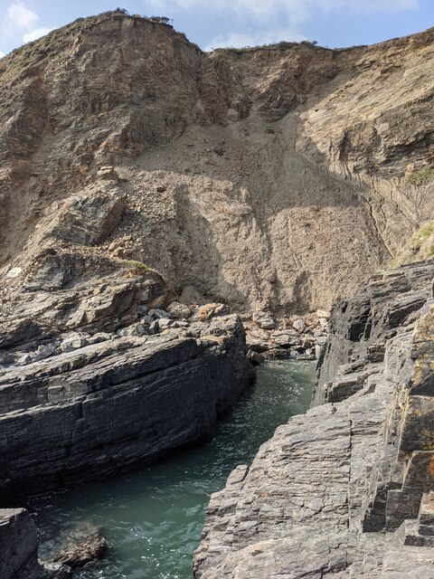
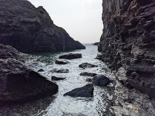
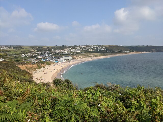
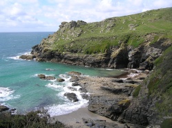
Bessy's Cove is a picturesque coastal area located in Cornwall, England. Nestled between towering cliffs, this hidden gem boasts a stunning combination of a rocky shoreline, a tranquil estuary, and a serene creek. With its natural beauty and peaceful atmosphere, Bessy's Cove has become a popular destination for nature lovers and outdoor enthusiasts.

The cove is characterized by its rugged and rocky beach, which is lined with colorful pebbles and small boulders. At low tide, visitors can explore fascinating rock pools teeming with marine life, providing a unique opportunity for nature exploration. The crystal-clear waters of the sea offer a refreshing swimming experience during the warmer months.

Adjacent to the beach is a picturesque estuary, where a small river meets the sea, creating a tranquil and idyllic setting. The estuary is home to a variety of bird species, making it a haven for birdwatchers. Visitors can enjoy leisurely walks along the estuary, taking in the breathtaking views and immersing themselves in the peaceful surroundings.

Further inland, a meandering creek flows through the lush green countryside, adding another dimension to the natural beauty of Bessy's Cove. The creek provides a tranquil spot for boating and kayaking, offering visitors an opportunity to explore the area from a different perspective.

Bessy's Cove is not only a haven for nature enthusiasts but also a place of historical significance. The cove has been inhabited for centuries, with remnants of ancient settlements and fishing communities still visible along the cliffs.

Overall, Bessy's Cove is a stunning destination that offers a harmonious blend of natural beauty, tranquility, and historical charm. Whether one seeks a peaceful beach day, a leisurely walk along the estuary, or an adventurous exploration of the creek, Bessy's Cove has something for everyone to enjoy.

If you have any feedback on the listing, please let us know in the comments section below.

Bessy's Cove Images

Images are sourced within 2km of 50.100567/-5.4175504 or Grid Reference SW5527. Thanks to Geograph Open Source API. All images are credited.

Looking down on Kenneggy Sand
Looking along Kenneggy Cliff  From the old mine.
Looking along Kenneggy Cliff
From the old mine.
The old mine above Kenneggy Sand
The footpath near the old mine
Farm tracks and footpaths A complicated junction on the way to the Coast Path.
Farm tracks and footpaths
A complicated junction on the way to the Coast Path.
The entrance to Higher Kenneggy wild camping site
Higher Kenneggy wild campsite Very few facilities, if not exactly 'wild'.
Higher Kenneggy wild campsite
Very few facilities, if not exactly 'wild'.
Coastal rocks near Pestreath Cove
The Coast Path near Pestreath Cove The path just passes through the corner of this square.
The Coast Path near Pestreath Cove
The path just passes through the corner of this square.
A hidden archway at Hoe Point This is a complex area of channels and stacks, not often accessed except by fishermen.
A hidden archway at Hoe Point
This is a complex area of channels and stacks, not often accessed except by fishermen.
The entrance to the zawn at Hoe Point The red rope and steel staples in the rock are an aid for the fishermen's access to the water.
The entrance to the zawn at Hoe Point
The red rope and steel staples in the rock are an aid for the fishermen's access to the water.
Narrow zawn, crumbling cliff At Hoe Point.
Narrow zawn, crumbling cliff
At Hoe Point.
Looking out along the channel An interesting zawn in the rocks, used somehow by fishermen.
Looking out along the channel
An interesting zawn in the rocks, used somehow by fishermen.
Shattered rocks at Hoe Point
Looking past Little Castle Towards Praa Sands.
Looking past Little Castle
Towards Praa Sands.
The Coast Path above Sydney Cove
Looking over Praa Sands The vegetation on the Coast Path restricts the view from this area considerably.
Looking over Praa Sands
The vegetation on the Coast Path restricts the view from this area considerably.
Kenneggy Methodist Church
Show me another place!

Bessy's Cove is located at Grid Ref: SW5527 (Lat: 50.100567, Lng: -5.4175504)

Unitary Authority: Cornwall

Police Authority: Devon and Cornwall

What 3 Words

///president.sugars.shuts. Near Germoe, Cornwall

Related Wikis

Prussia Cove

Prussia Cove (Cornish: Porth Legh), formerly called King's Cove, is a small private estate on the coast of Mount's Bay and to the east of Cudden Point...

Acton Castle

Acton Castle is a small castellated mansion near Perranuthnoe, Cornwall. It is a Grade II* listed building. It was built c. 1775, and according to some...

Kenneggy

Kenneggy comprises two separate hamlets, Higher Kenneggy (Cornish: Keunegi Wartha) to the west and Lower Kennegy (Cornish: Keunegi Woles) to the east,...

Kenneggy Downs

Kenneggy Downs is a hamlet on the A394, between the towns of Helston and Penzance in Cornwall, UK. It is in the west of the civil parish of Breage and...

Nearby Amenities

Located within 500m of 50.100567,-5.4175504
Source: PGS
Lat/Long: 50.0984511/-5.4237211
Source: PGS
Lat/Long: 50.0984288/-5.4233654
Source: PGS
Lat/Long: 50.0986215/-5.4228783
Source: PGS
Lat/Long: 50.0989757/-5.4227976
Source: PGS
Lat/Long: 50.099539/-5.4227756
Source: PGS
Lat/Long: 50.0994422/-5.4215445
Source: PGS
Lat/Long: 50.0990741/-5.421358
Source: PGS
Lat/Long: 50.0987369/-5.4213183
Source: PGS
Lat/Long: 50.0987472/-5.4210195
Source: PGS
Lat/Long: 50.0989897/-5.4206926
Source: PGS
Lat/Long: 50.0987543/-5.4203039
Created By: almien_coastlines
Source: PGS
Lat/Long: 50.098869/-5.419502
Created By: almien_coastlines
Source: PGS
Lat/Long: 50.099001/-5.41931
Created By: almien_coastlines
Source: PGS
Lat/Long: 50.099522/-5.418938
Source: PGS
Lat/Long: 50.0997537/-5.418704
Source: PGS
Lat/Long: 50.099804/-5.4181871
Created By: almien_coastlines
Source: PGS
Lat/Long: 50.100051/-5.418167
Source: PGS
Lat/Long: 50.1007356/-5.4182537
Source: PGS
Lat/Long: 50.100594/-5.417942
Source: PGS
Lat/Long: 50.1006192/-5.4176067
Created By: almien_coastlines
Source: PGS
Lat/Long: 50.10084/-5.41721
Source: PGS
Lat/Long: 50.100146/-5.4169973
Created By: almien_coastlines
Source: PGS
Lat/Long: 50.100088/-5.416375
Source: PGS
Lat/Long: 50.0995192/-5.4160867
Source: PGS
Lat/Long: 50.0996975/-5.4150731
Source: PGS
Lat/Long: 50.1001073/-5.4147815
Source: PGS
Lat/Long: 50.1005493/-5.4149867
Source: PGS
Lat/Long: 50.1010343/-5.4147504
Source: PGS
Lat/Long: 50.1020743/-5.4150018
Created By: almien_coastlines
Source: PGS
Lat/Long: 50.102959/-5.413929
Source: PGS
Lat/Long: 50.1033679/-5.413372
Prussia Cove
Is In: Cornwall, England, UK
Name Kw: Porth Legh
Place: hamlet
Source: NPE
Wikidata: Q2856613
Lat/Long: 50.1015133/-5.4182846
Post Box
Brand: Royal Mail
Brand Wikidata: Q638098
Brand Wikipedia: en:Royal Mail
Collection Times: Mo-Fr 10:00; Sa 10:00
Description: Prussia Cove
Operator: Royal Mail
Operator Wikidata: Q638098
Post Box Mounting: brick_pillar
Post Box Type: wall
Ref: TR20 92
Royal Cypher: EIIR
Royal Cypher Wikidata: Q33102113
Lat/Long: 50.1016445/-5.4184379
Barrier: stile
Lat/Long: 50.1000038/-5.4219756
HMS Warspite
Historic: memorial
Lat/Long: 50.0993194/-5.4197085
Life Ring
Emergency: life_ring
Survey Date: 2022-07-17
Lat/Long: 50.0990054/-5.4211435
Life Ring
Emergency: life_ring
Survey Date: 2022-07-17
Lat/Long: 50.1010243/-5.4182727
The data included in this document is from www.openstreetmap.org. The data is made available under ODbL.

Have you been to Bessy's Cove?

Leave your review of Bessy's Cove below (or comments, questions and feedback).