Battery Point

Coastal Feature, Headland, Point in Cornwall

England

Battery Point

Views out to sea from PROW
Views out to sea from PROW Credit: thejackrustles

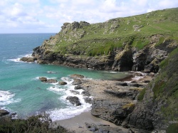
Battery Point is a prominent headland located on the southern coast of Cornwall, England. Situated near the town of Penzance, it is a well-known coastal feature that offers breathtaking views of the surrounding area. The point is named after the historic artillery battery that once stood there, serving as a defense against potential invaders.

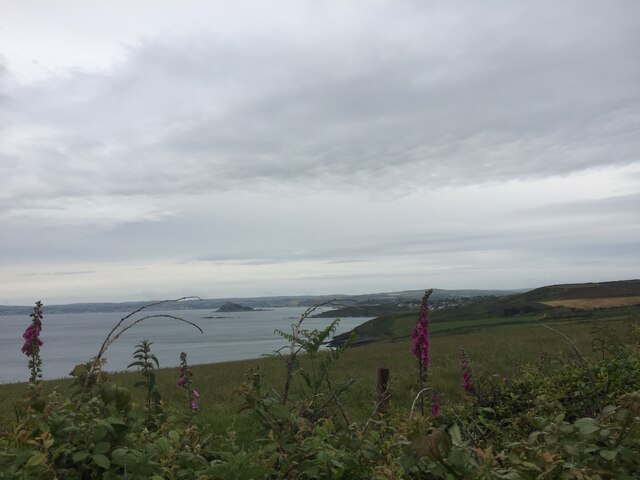
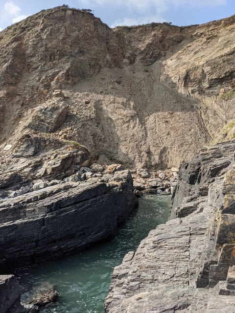
This stunning headland is characterized by its rugged cliffs, which provide a dramatic backdrop to the crashing waves of the Atlantic Ocean. The area is rich in geological diversity, with layers of sedimentary rock that reveal the region's geological history. It is also home to a variety of flora and fauna, including seabirds, wildflowers, and marine life.

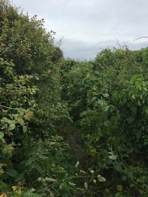
Visitors to Battery Point can explore the coastal path that winds along the headland, providing access to picturesque viewpoints and secluded coves. The area is a popular spot for birdwatching, as it serves as a nesting site for several species, including gulls and cormorants. During low tide, it is possible to walk across a causeway to the St. Michael's Mount, a nearby tidal island that boasts a medieval castle and picturesque gardens.

Battery Point holds historical significance as well. The remains of the artillery battery, which was active during the 18th and 19th centuries, can still be seen today. The site offers a glimpse into Cornwall's military past and serves as a reminder of the region's strategic importance.

Overall, Battery Point is a captivating coastal feature that combines natural beauty, wildlife, and historical interest. It is a must-visit destination for nature enthusiasts, history buffs, and anyone seeking a memorable experience along Cornwall's stunning coastline.

If you have any feedback on the listing, please let us know in the comments section below.

Battery Point Images

Images are sourced within 2km of 50.09978/-5.4158579 or Grid Reference SW5527. Thanks to Geograph Open Source API. All images are credited.

Views out to sea from PROW
Very overgrown footpath
Lovely coastline
Lovely coastline
Cudden Point Trig Point Flush Bracket S8075 <span class="nowrap"><a title="http://trigpointing.uk/trig/2667" rel="nofollow ugc noopener" href="http://trigpointing.uk/trig/2667">Link</a><img style="margin-left:2px;" alt="External link" title="External link - shift click to open in new window" src="https://s1.geograph.org.uk/img/external.png" width="10" height="10"/></span>
Cudden Point Trig Point Flush Bracket S8075
Coastal views
Coastal views
Prussia Cove
Prussia Cove
Looking down on Kenneggy Sand
Looking along Kenneggy Cliff  From the old mine.
Looking along Kenneggy Cliff
From the old mine.
The old mine above Kenneggy Sand
The footpath near the old mine
Farm tracks and footpaths A complicated junction on the way to the Coast Path.
Farm tracks and footpaths
A complicated junction on the way to the Coast Path.
The entrance to Higher Kenneggy wild camping site
Higher Kenneggy wild campsite Very few facilities, if not exactly 'wild'.
Higher Kenneggy wild campsite
Very few facilities, if not exactly 'wild'.
Coastal rocks near Pestreath Cove
The Coast Path near Pestreath Cove The path just passes through the corner of this square.
The Coast Path near Pestreath Cove
The path just passes through the corner of this square.
A hidden archway at Hoe Point This is a complex area of channels and stacks, not often accessed except by fishermen.
A hidden archway at Hoe Point
This is a complex area of channels and stacks, not often accessed except by fishermen.
The entrance to the zawn at Hoe Point The red rope and steel staples in the rock are an aid for the fishermen's access to the water.
The entrance to the zawn at Hoe Point
The red rope and steel staples in the rock are an aid for the fishermen's access to the water.
Narrow zawn, crumbling cliff At Hoe Point.
Narrow zawn, crumbling cliff
At Hoe Point.
Show me another place!

Battery Point is located at Grid Ref: SW5527 (Lat: 50.09978, Lng: -5.4158579)

Unitary Authority: Cornwall

Police Authority: Devon and Cornwall

What 3 Words

///inferior.geologist.exist. Near Germoe, Cornwall

Related Wikis

Prussia Cove

Prussia Cove (Cornish: Porth Legh), formerly called King's Cove, is a small private estate on the coast of Mount's Bay and to the east of Cudden Point...

Acton Castle

Acton Castle is a small castellated mansion near Perranuthnoe, Cornwall. It is a Grade II* listed building. It was built c. 1775, and according to some...

Kenneggy

Kenneggy comprises two separate hamlets, Higher Kenneggy (Cornish: Keunegi Wartha) to the west and Lower Kennegy (Cornish: Keunegi Woles) to the east,...

Kenneggy Downs

Kenneggy Downs is a hamlet on the A394, between the towns of Helston and Penzance in Cornwall, UK. It is in the west of the civil parish of Breage and...

Nearby Amenities

Located within 500m of 50.09978,-5.4158579
Source: PGS
Lat/Long: 50.099539/-5.4227756
Source: PGS
Lat/Long: 50.0994422/-5.4215445
Source: PGS
Lat/Long: 50.0990741/-5.421358
Source: PGS
Lat/Long: 50.0987369/-5.4213183
Source: PGS
Lat/Long: 50.0987472/-5.4210195
Source: PGS
Lat/Long: 50.0989897/-5.4206926
Source: PGS
Lat/Long: 50.0987543/-5.4203039
Created By: almien_coastlines
Source: PGS
Lat/Long: 50.098869/-5.419502
Created By: almien_coastlines
Source: PGS
Lat/Long: 50.099001/-5.41931
Created By: almien_coastlines
Source: PGS
Lat/Long: 50.099522/-5.418938
Source: PGS
Lat/Long: 50.0997537/-5.418704
Source: PGS
Lat/Long: 50.099804/-5.4181871
Created By: almien_coastlines
Source: PGS
Lat/Long: 50.100051/-5.418167
Source: PGS
Lat/Long: 50.1007356/-5.4182537
Source: PGS
Lat/Long: 50.100594/-5.417942
Source: PGS
Lat/Long: 50.1006192/-5.4176067
Created By: almien_coastlines
Source: PGS
Lat/Long: 50.10084/-5.41721
Source: PGS
Lat/Long: 50.100146/-5.4169973
Created By: almien_coastlines
Source: PGS
Lat/Long: 50.100088/-5.416375
Source: PGS
Lat/Long: 50.0995192/-5.4160867
Source: PGS
Lat/Long: 50.0996975/-5.4150731
Source: PGS
Lat/Long: 50.1001073/-5.4147815
Source: PGS
Lat/Long: 50.1005493/-5.4149867
Source: PGS
Lat/Long: 50.1010343/-5.4147504
Source: PGS
Lat/Long: 50.1020743/-5.4150018
Created By: almien_coastlines
Source: PGS
Lat/Long: 50.102959/-5.413929
Source: PGS
Lat/Long: 50.1033679/-5.413372
Prussia Cove
Is In: Cornwall, England, UK
Name Kw: Porth Legh
Place: hamlet
Source: NPE
Wikidata: Q2856613
Lat/Long: 50.1015133/-5.4182846
Post Box
Brand: Royal Mail
Brand Wikidata: Q638098
Brand Wikipedia: en:Royal Mail
Collection Times: Mo-Fr 10:00; Sa 10:00
Description: Prussia Cove
Operator: Royal Mail
Operator Wikidata: Q638098
Post Box Mounting: brick_pillar
Post Box Type: wall
Ref: TR20 92
Royal Cypher: EIIR
Royal Cypher Wikidata: Q33102113
Lat/Long: 50.1016445/-5.4184379
Barrier: stile
Lat/Long: 50.1000038/-5.4219756
HMS Warspite
Historic: memorial
Lat/Long: 50.0993194/-5.4197085
Life Ring
Emergency: life_ring
Survey Date: 2022-07-17
Lat/Long: 50.0990054/-5.4211435
Life Ring
Emergency: life_ring
Survey Date: 2022-07-17
Lat/Long: 50.1010243/-5.4182727
The data included in this document is from www.openstreetmap.org. The data is made available under ODbL.

Have you been to Battery Point?

Leave your review of Battery Point below (or comments, questions and feedback).