Oitir Mhic Dhomhnuill Ghlais

Coastal Marsh, Saltings in Inverness-shire

Scotland

Oitir Mhic Dhomhnuill Ghlais

Houses at Samhla
Houses at Samhla Credit: Sandy Gerrard

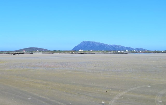
Oitir Mhic Dhomhnuill Ghlais, also known as the Coastal Marsh or Saltings, is a prominent geographical feature located in Inverness-shire, Scotland. This coastal marshland stretches along the shores of the county, offering breathtaking views of the surrounding landscape.

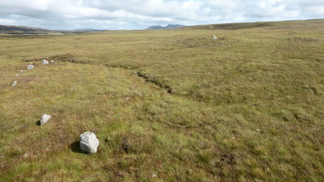
Covering an extensive area, Oitir Mhic Dhomhnuill Ghlais is characterized by its diverse ecosystem, comprising a mixture of salt marshes, mudflats, and tidal creeks. These marshlands are formed due to the tidal influence of the nearby sea, resulting in a unique habitat that supports a variety of plant and animal species.

The marshes of Oitir Mhic Dhomhnuill Ghlais are home to numerous bird species, making it an ideal location for birdwatching enthusiasts. Visitors can spot a wide range of avian creatures, including wading birds like curlews, oystercatchers, and various species of gulls. The marshes also provide a vital breeding ground for migratory birds, such as sandpipers and terns.

Aside from its ecological significance, Oitir Mhic Dhomhnuill Ghlais offers recreational opportunities for nature lovers and hikers. The marshland's expansive trails allow visitors to explore the stunning coastal landscape while enjoying the tranquility of the surroundings. The area is also a popular spot for photography enthusiasts, as the ever-changing tides and interplay of light create a captivating setting for capturing stunning images.

In conclusion, Oitir Mhic Dhomhnuill Ghlais is an exceptional coastal marshland found in Inverness-shire, Scotland. With its diverse ecosystem, abundant birdlife, and scenic beauty, it is a must-visit destination for those seeking a unique and enriching natural experience.

If you have any feedback on the listing, please let us know in the comments section below.

Oitir Mhic Dhomhnuill Ghlais Images

Images are sourced within 2km of 57.534723/-7.3287599 or Grid Reference NF8161. Thanks to Geograph Open Source API. All images are credited.

Houses at Samhla
Houses at Samhla
Outside Talla Chairinis, North Uist Outside a community hall
Outside Talla Chairinis, North Uist
Outside a community hall
Blar Chairinis Site of battle in 1601.
Blar Chairinis
Site of battle in 1601.
Stone barn at Carinish
The ruins of Trinity Temple (Teampull na Trianaid) According to the plaque "Medieval monastery and college of European significance, founded by Beathag, daughter of Somhairle (Somerled).  Enlarged about 1350 to 1390 by Amie Mic Ruarie, first wife of John, Lord of the Isles.  Reconstructed in the 16th century.  Destroyed after the reformation.  Later restored in the 19th century by Dotair Ban."
The ruins of Trinity Temple (Teampull na Trianaid)
According to the plaque "Medieval monastery and college of European significance, founded by Beathag, daughter of Somhairle (Somerled). Enlarged about 1350 to 1390 by Amie Mic Ruarie, first wife of John, Lord of the Isles. Reconstructed in the 16th century. Destroyed after the reformation. Later restored in the 19th century by Dotair Ban."
Field and houses at Carinish And also the site of Feith na Fala (The ditch of blood) - a battle waged in 1601 between the MacLeods and the MacDonalds.
Field and houses at Carinish
And also the site of Feith na Fala (The ditch of blood) - a battle waged in 1601 between the MacLeods and the MacDonalds.
Baleshare - North Uist Causeway Looking east from Samhla to North Uist. Interestingly, although both sides are open to the sea, there is water to the south but it was dry on the north.
Baleshare - North Uist Causeway
Looking east from Samhla to North Uist. Interestingly, although both sides are open to the sea, there is water to the south but it was dry on the north.
Shore at Samhla Looking south from the west end of the causeway.
Shore at Samhla
Looking south from the west end of the causeway.
Bagh a’ Ghriasaiche
Bagh a’ Ghriasaiche
Fèithe na Fala - The ditch of blood
View from Temple View Hotel Teampull na Trionaid is a ruined 13th-century church and seminary at Carinish, North Uist, Scotland. Amie mac Ruari is said to have rebuilt the church in the 14th century after her divorce from John of Islay, Lord of the Isles. The ruins are protected as a scheduled monument.
View from Temple View Hotel
Teampull na Trionaid is a ruined 13th-century church and seminary at Carinish, North Uist, Scotland. Amie mac Ruari is said to have rebuilt the church in the 14th century after her divorce from John of Islay, Lord of the Isles. The ruins are protected as a scheduled monument.
Closer to the temple The ruins of Trinity Temple (Teampull na Trianaid)
Closer to the temple
The ruins of Trinity Temple (Teampull na Trianaid)
Free Church, Cairinis Current OS maps show this as a church, but older versions show it as a pub, which was its original purpose. Enough said.
Free Church, Cairinis
Current OS maps show this as a church, but older versions show it as a pub, which was its original purpose. Enough said.
A not very useful gate A rusty old metal gate at the point where a fence once crossed the track.
A not very useful gate
A rusty old metal gate at the point where a fence once crossed the track.
Track above Loch Creag nan Speireag This track, which is indistinct in places, forms part of the Hebridean Way, a relatively new walking route through the Western Isles.
Track above Loch Creag nan Speireag
This track, which is indistinct in places, forms part of the Hebridean Way, a relatively new walking route through the Western Isles.
Cotton grass, Creag nan Speireag Looking over cotton grass towards Loch nan Speireag and the houses at Gearraidh Cladach.
Cotton grass, Creag nan Speireag
Looking over cotton grass towards Loch nan Speireag and the houses at Gearraidh Cladach.
A sandy island surrounded by sand This is the part of the extensive area of tidal sand on the east side of Baile Sear island. The sand must be firm due to the number of vehicle tyre tracks across it. Looking due east towards the profile of Eabhal.
A sandy island surrounded by sand
This is the part of the extensive area of tidal sand on the east side of Baile Sear island. The sand must be firm due to the number of vehicle tyre tracks across it. Looking due east towards the profile of Eabhal.
Sornach a' Phobuill stone circle A stone circle also known as Sornach Coir' Fhinn. The north western sector survives best. <span class="nowrap"><a title="https://canmore.org.uk/site/10269/north-uist-loch-a-phobuill-sornach-coir-fhinn" rel="nofollow ugc noopener" href="https://canmore.org.uk/site/10269/north-uist-loch-a-phobuill-sornach-coir-fhinn">Link</a><img style="margin-left:2px;" alt="External link" title="External link - shift click to open in new window" src="https://s1.geograph.org.uk/img/external.png" width="10" height="10"/></span>
Sornach a' Phobuill stone circle
A stone circle also known as Sornach Coir' Fhinn. The north western sector survives best. LinkExternal link
Show me another place!

Oitir Mhic Dhomhnuill Ghlais is located at Grid Ref: NF8161 (Lat: 57.534723, Lng: -7.3287599)

Unitary Authority: Na h-Eileanan an Iar

Police Authority: Highlands and Islands

What 3 Words

///guru.eyelashes.glitz. Near Balivanich, Na h-Eileanan Siar

Related Wikis

Battle of Carinish

The Battle of Carinish was a Scottish clan battle fought in North Uist in 1601. It was part of a year of feuding between Clan MacLeod of Dunvegan and the...

Teampull na Trionaid

Teampull na Trionaid ("trinity church") is a ruined 13th-century Augustinian nunnery at Carinish, on North Uist, in the Outer Hebrides of Scotland. �...

Carinish

Carinish (Scottish Gaelic: Càirinis), is a hamlet on North Uist, in the Outer Hebrides, Scotland. It is in the south of the island, about two miles (three...

Baleshare

Baleshare (Scottish Gaelic: Baile Sear) is a flat tidal island in the Outer Hebrides of Scotland. Baleshare lies to the south-west of North Uist. Its economics...

Nearby Amenities

Located within 500m of 57.534723,-7.3287599
Cladach a' Bhaile Shear
Name En: Claddach Baleshare
Name Gd: Cladach a' Bhaile Shear
Place: hamlet
Lat/Long: 57.5387258/-7.3251343
Power: pole
Lat/Long: 57.5322867/-7.3226665
Power: pole
Lat/Long: 57.5330124/-7.3229025
Power: pole
Lat/Long: 57.5336747/-7.3231252
Power: pole
Lat/Long: 57.5343543/-7.3233397
Power: pole
Lat/Long: 57.5351058/-7.3235624
Power: pole
Lat/Long: 57.5358271/-7.3237823
Power: pole
Lat/Long: 57.536857/-7.3222561
Power: pole
Lat/Long: 57.5370212/-7.3240129
Power: pole
Lat/Long: 57.5378072/-7.3241551
Power: pole
Lat/Long: 57.5384421/-7.3242731
Power: pole
Lat/Long: 57.5366537/-7.3231508
Power: pole
Lat/Long: 57.5355594/-7.3225652
Power: pole
Lat/Long: 57.5352985/-7.3212518
Power: pole
Lat/Long: 57.5364801/-7.3239611
The data included in this document is from www.openstreetmap.org. The data is made available under ODbL.

Have you been to Oitir Mhic Dhomhnuill Ghlais?

Leave your review of Oitir Mhic Dhomhnuill Ghlais below (or comments, questions and feedback).