Black Geo

Coastal Feature, Headland, Point in Shetland

Scotland

Black Geo

Outer Dale, Lambhoga, Fetlar
Outer Dale, Lambhoga, Fetlar Credit: Mike Pennington

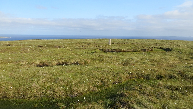
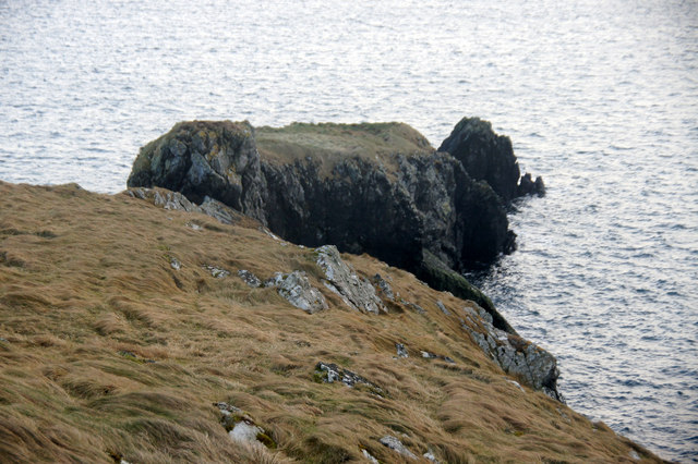
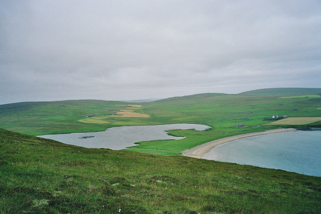
Black Geo is a prominent coastal feature located in Shetland, Scotland. It is classified as a headland, also known as a point, and is characterized by its distinctive dark cliffs and rugged terrain. The name "Black Geo" refers to the geological formation of the area, where "geo" is a local term for a narrow and steep-sided inlet.

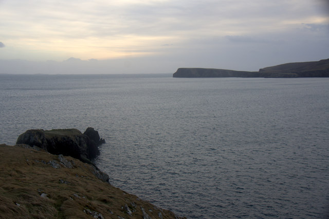
Situated on the western coast of Shetland, Black Geo offers breathtaking views of the North Atlantic Ocean. The headland juts out into the sea, providing a commanding vantage point to observe the surrounding landscape. The cliffs that define Black Geo are composed of basalt, a volcanic rock, which gives them their dark color and adds to the striking beauty of the area.

The rugged nature of Black Geo makes it a popular destination for outdoor enthusiasts and nature lovers. Hikers and walkers often explore the coastal path that winds along the headland, offering panoramic vistas and opportunities to spot seabirds and marine life. The challenging terrain also attracts rock climbers, who find the cliffs of Black Geo perfect for their adventurous pursuits.

In addition to its natural beauty, Black Geo holds historical significance as well. It has been used as a navigational landmark by sailors for centuries, and its location played a role in various maritime activities, including fishing and trade.

Overall, Black Geo is a captivating coastal feature in Shetland, offering a unique blend of natural beauty, ruggedness, and historical importance. Its dark cliffs, stunning views, and diverse wildlife make it a must-visit destination for those seeking to experience the wonders of this remote Scottish archipelago.

If you have any feedback on the listing, please let us know in the comments section below.

Black Geo Images

Images are sourced within 2km of 60.592014/-0.88773592 or Grid Reference HU6190. Thanks to Geograph Open Source API. All images are credited.

Outer Dale, Lambhoga, Fetlar
North of Hoganeap, Lambhoga, Fetlar
Three Geos, Hoganeap, Fetlar Although this area seems to be named Three Stacks on the OS 1:10000 map, I am informed by Andrew Leaper of Fetlar that the area in the photo is named Three Geos and that Three Stacks is further north along the coast.
Three Geos, Hoganeap, Fetlar
Although this area seems to be named Three Stacks on the OS 1:10000 map, I am informed by Andrew Leaper of Fetlar that the area in the photo is named Three Geos and that Three Stacks is further north along the coast.
Looking north from path up to Lamb Hoga There is a very good track from the car park beside Fetlar Kirk up onto Lamb Hoga with views to Out Skerries, Bressay and across the whole of Fetlar.  I had assumed that Lamb Hoga would be pronounced as written but oh no, it's pronounced as a single word "Lahmuga" with the stress on the first sylable "Lahm".
Looking north from path up to Lamb Hoga
There is a very good track from the car park beside Fetlar Kirk up onto Lamb Hoga with views to Out Skerries, Bressay and across the whole of Fetlar. I had assumed that Lamb Hoga would be pronounced as written but oh no, it's pronounced as a single word "Lahmuga" with the stress on the first sylable "Lahm".
The Peat Road The bogs of Lamb Hoga provided Fetlar with high quality fuel. Every year, islanders would move to the peninsula to cast and dry peats. The fuel was then taken off via this road or by boat across to Aith for the eastern side of the island.
 The beach at Tresta is in the background along with Vord Hill.
The Peat Road
The bogs of Lamb Hoga provided Fetlar with high quality fuel. Every year, islanders would move to the peninsula to cast and dry peats. The fuel was then taken off via this road or by boat across to Aith for the eastern side of the island. The beach at Tresta is in the background along with Vord Hill.
Peat Road, Lamb Hoga The route which was used to carry winter fuel off the bogs of Lamb Hoga up to the 1950s.
Peat Road, Lamb Hoga
The route which was used to carry winter fuel off the bogs of Lamb Hoga up to the 1950s.
Bog, Lamb Hoga The west side of Gillis Field which was the source of Fetlar's peat. The moorland is now home to many bonxies and they were pretty mean today.
Bog, Lamb Hoga
The west side of Gillis Field which was the source of Fetlar's peat. The moorland is now home to many bonxies and they were pretty mean today.
The Dale A shallow reentrant on the boggy Lamb Hoga plateau. There is a view over the Wick of Tresta towards Aithbank where peats cut here were once landed.
The Dale
A shallow reentrant on the boggy Lamb Hoga plateau. There is a view over the Wick of Tresta towards Aithbank where peats cut here were once landed.
The Peat Road Lamb Hoga was the source of Fetlar's peat and this was one of the ways the peat was carried to the crofts. Much of the peat was taken out by boat and landed at Airthbank.
The Peat Road
Lamb Hoga was the source of Fetlar's peat and this was one of the ways the peat was carried to the crofts. Much of the peat was taken out by boat and landed at Airthbank.
Gillis Field Triangulation pillar amongst the bogs.
Gillis Field
Triangulation pillar amongst the bogs.
Gillis Field Triangulation pillar on Lamb Hoga.
Gillis Field
Triangulation pillar on Lamb Hoga.
Gillis Field The higher parts of Lamb Hoga. The peninsula was the source of Fetlar's peat.
Gillis Field
The higher parts of Lamb Hoga. The peninsula was the source of Fetlar's peat.
The Heog, Houbie, Fetlar
The Heog, near Houbie, Fetlar And the view across the Wick of Tresta towards the Head of Lambhoga.
The Heog, near Houbie, Fetlar
And the view across the Wick of Tresta towards the Head of Lambhoga.
SW of Tresta towards Silda Wick Looking across the inland end of the Wick of Tresta
SW of Tresta towards Silda Wick
Looking across the inland end of the Wick of Tresta
Papil Water Taken from Fitsyi Field on Lamb Hoga, with Stackaberg (centre) and Vord Hill (right) in the distance.
Papil Water
Taken from Fitsyi Field on Lamb Hoga, with Stackaberg (centre) and Vord Hill (right) in the distance.
View towards Garths of Tresta Taken from Lamb Hoga with the Wick of Tresta in foreground.
View towards Garths of Tresta
Taken from Lamb Hoga with the Wick of Tresta in foreground.
Tresta beach, Fetlar The beach at Tresta on Fetlar.
Tresta beach, Fetlar
The beach at Tresta on Fetlar.
Show me another place!

Black Geo is located at Grid Ref: HU6190 (Lat: 60.592014, Lng: -0.88773592)

Unitary Authority: Shetland Islands

Police Authority: Highlands and Islands

What 3 Words

///jeeps.willing.cleanest. Near Houbie, Shetland Islands

Related Wikis

Fetlar

Fetlar (Scots: Fetlar) is one of the North Isles of Shetland, Scotland, with a usually resident population of 61 at the time of the 2011 census. Its main...

Haltadans

Haltadans, also known as Fairy Ring or Haltadans stone circle, is a stone circle on the island of Fetlar in Shetland, Scotland. This site is a ring of...

Funzie Girt

Funzie Girt (; Scots: Funyie Girt "Finns' dyke") is an ancient dividing wall that was erected from north to south across the island of Fetlar in Shetland...

Brough Lodge

Brough Lodge is a 19th-century Gothic mansion on Fetlar, one of the Shetland Islands, in northern Scotland. Built by the Nicolson family, who were responsible...

Urie Lingey

For other islands with similar names, see Linga (disambiguation) Urie Lingey is one of the Shetland Islands. It is between Fetlar and Unst, and Yell is...

Hamars Ness

Hamars Ness is a headland on the island of Fetlar in Shetland, Scotland. The name is from the Old Norse Hamarsnes meaning "craggy headland". A ro-ro ferry...

Hascosay

Hascosay (Scots: Hascosay; Old Norse "Hafskotsey") is a small island lying between Yell and Fetlar in the Shetland Islands, Scotland. == Geography and... ==

Sound Gruney

For other islands with similar names, see Gruney (disambiguation) Sound Gruney is one of the Shetland islands. It lies about 1.5 kilometres (0.93 mi)...

Nearby Amenities

Located within 500m of 60.592014,-0.88773592
Turning Circle
Lat/Long: 60.5932274/-0.8834626
Tourism: picnic_site
Lat/Long: 60.592929/-0.8926566
Turning Circle
Lat/Long: 60.5945235/-0.8901125
Power: pole
Lat/Long: 60.5938991/-0.8924958
Power: pole
Lat/Long: 60.5942876/-0.891549
Power: pole
Lat/Long: 60.5949461/-0.8899235
Power: pole
Lat/Long: 60.5958271/-0.8872145
Power: pole
Lat/Long: 60.5961853/-0.8875364
Power: pole
Lat/Long: 60.5960312/-0.8841729
Power: pole
Lat/Long: 60.5959022/-0.8848703
Power: pole
Lat/Long: 60.5957757/-0.8855462
Power: pole
Lat/Long: 60.5956506/-0.8862006
Power: pole
Lat/Long: 60.5955111/-0.8869436
Power: pole
Lat/Long: 60.5953043/-0.8880219
Tresta
Place: hamlet
Lat/Long: 60.5932064/-0.8848476
Power: pole
Lat/Long: 60.5950584/-0.8893596
Power: pole
Lat/Long: 60.5946958/-0.890543
Power: pole
Lat/Long: 60.5933492/-0.8850487
Power: pole
Lat/Long: 60.5938255/-0.8854648
Power: pole
Lat/Long: 60.5943363/-0.8859278
Power: pole
Lat/Long: 60.5949135/-0.8864245
The data included in this document is from www.openstreetmap.org. The data is made available under ODbL.

Have you been to Black Geo?

Leave your review of Black Geo below (or comments, questions and feedback).