Geos of Houlland
Coastal Feature, Headland, Point in Shetland
Scotland
Geos of Houlland

Geos of Houlland is a prominent coastal feature located in the Shetland Islands, an archipelago in the North Atlantic Ocean. It is categorized as a headland or a point, as it juts out into the sea, forming a distinct landform.
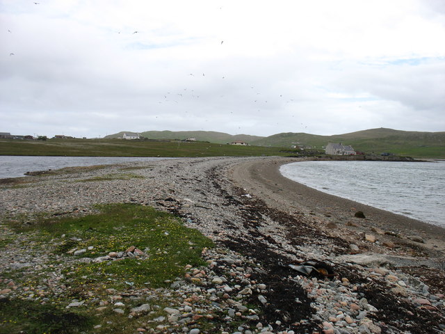
Situated on the west coast of the mainland of Shetland, Geos of Houlland offers breathtaking views of the surrounding rugged coastline and the vast expanse of the Atlantic Ocean. It is known for its dramatic cliffs, which rise steeply from the sea, providing a nesting ground for various seabird species.
The name "Geos of Houlland" refers to the series of narrow, steep-sided inlets or sea caves that have been carved into the cliffs over thousands of years by the relentless force of the waves. These geos are a result of the erosion caused by the sea, creating unique and picturesque formations. The caves are accessible during low tide, attracting adventurers and nature enthusiasts to explore their intricate interiors.
Geos of Houlland is also renowned for its rich biodiversity. The surrounding waters are home to a diverse range of marine life, including seals, otters, and various species of fish. The surrounding cliffs and grassy slopes provide a habitat for several bird species, including puffins, fulmars, and guillemots.
Due to its stunning natural beauty, Geos of Houlland is a popular destination for tourists and locals alike. Visitors can enjoy scenic walks along the coastal paths, observe the wildlife, or simply soak in the tranquility of the surroundings. The area is also of interest to geologists and nature researchers, as it provides a unique opportunity to study the erosional processes shaping the coastline.
If you have any feedback on the listing, please let us know in the comments section below.
Geos of Houlland Images
Images are sourced within 2km of 60.573811/-1.3217728 or Grid Reference HU3788. Thanks to Geograph Open Source API. All images are credited.


Geos of Houlland is located at Grid Ref: HU3788 (Lat: 60.573811, Lng: -1.3217728)
Unitary Authority: Shetland Islands
Police Authority: Highlands and Islands
What 3 Words
///crows.dishing.reinvest. Near Ulsta, Shetland Islands
Nearby Locations
Related Wikis

North Roe
North Roe is a village, and protected area at the northern tip in the large Northmavine peninsula of the Mainland of Shetland, Scotland. It is a small...

Muckle Holm, Yell Sound
Muckle Holm is a small island in Shetland. It is in Yell Sound, near the Northmavine. It is 23 metres (75 ft) at its highest point. There is a lighthouse...

Yell Sound
Yell Sound is the strait running between Yell and Mainland, Shetland, Scotland. It is the boundary between the Mainland and the North Isles and it contains...

Little Holm, Yell Sound
Little Holm is a small island in Yell Sound, in Shetland, Scotland. It lies between Northmavine and the island of Yell. There is a lighthouse here. In...

Fethaland
Fethaland or Fedeland (pronounced [ˈfeɪdələnd]) is an abandoned settlement at the extreme north end of Mainland, Shetland. It was the site of the largest...

Lamba, Shetland
Lamba is an uninhabited island in Yell Sound in Shetland. It lies 1.5 km (0.93 mi) north of the entrance to the Sullom Voe inlet and 1.4 kilometres (0...

Ollaberry
Ollaberry (Old Norse: Olafrsberg, meaning Olaf's Hill) is a village on Mainland, Shetland, Scotland on the west shore of Yell Sound, 10.9 miles (17.5 km...

Uyea, Northmavine
Uyea (Scots: Öya in Shetland dialect spelling) is an uninhabited tidal island located to the northwest of Mainland, Shetland. Uyea lies off the Northmavine...
Nearby Amenities
Located within 500m of 60.573811,-1.3217728Have you been to Geos of Houlland?
Leave your review of Geos of Houlland below (or comments, questions and feedback).