Blanches Geo

Coastal Feature, Headland, Point in Shetland

Scotland

Blanches Geo

Pier on Fugla Ness from Scatsta These piers around Sullom Voe house booms to be deployed in the event of an oilspill. Ronas Hill is in the background.
Pier on Fugla Ness from Scatsta Credit: Mike Pennington

Blanches Geo is a prominent coastal feature located on the Shetland Islands, situated off the northeastern coast of Scotland. It is classified as a headland and point, jutting out into the North Sea. Blanches Geo is known for its rugged and dramatic cliffs, which reach heights of up to 100 feet (30 meters) above sea level.

The headland is composed of layers of sedimentary rocks, including sandstone and shale, which have been shaped by the relentless action of the waves over thousands of years. These geological formations provide a striking backdrop to the surrounding landscape, creating a sense of awe and grandeur.

Blanches Geo is also home to a diverse range of flora and fauna. The cliffs provide nesting sites for various seabird species, including guillemots, fulmars, and puffins. Visitors to the area can often observe these birds in their natural habitat, soaring overhead or perched on the cliff ledges.

The headland is accessible to the public, with a footpath leading to a viewpoint that offers panoramic views of the North Sea and the surrounding coastline. The area is a popular spot for outdoor enthusiasts, who can enjoy activities such as hiking, birdwatching, and photography.

Blanches Geo is not only a natural attraction but also holds historical significance. The nearby village of Lerwick, the capital of the Shetland Islands, has a rich maritime heritage, and Blanches Geo served as a prominent landmark for sailors in the past.

Overall, Blanches Geo is a captivating coastal feature that showcases the raw beauty and geological diversity of the Shetland Islands. Its impressive cliffs, abundant wildlife, and historical importance make it a must-visit destination for nature lovers and history enthusiasts alike.

If you have any feedback on the listing, please let us know in the comments section below.

Blanches Geo Images

Images are sourced within 2km of 60.457119/-1.3242067 or Grid Reference HU3775. Thanks to Geograph Open Source API. All images are credited.

Pier on Fugla Ness from Scatsta These piers around Sullom Voe house booms to be deployed in the event of an oilspill. Ronas Hill is in the background.
Pier on Fugla Ness from Scatsta
These piers around Sullom Voe house booms to be deployed in the event of an oilspill. Ronas Hill is in the background.
Navigation aid in Sullom Voe From Houbs Ayre, Scatsta, looking towards Punds, Sullom.
Navigation aid in Sullom Voe
From Houbs Ayre, Scatsta, looking towards Punds, Sullom.
Navigation aid on Ungam in Sullom Voe Photographed from Scatsta.
Navigation aid on Ungam in Sullom Voe
Photographed from Scatsta.
Loading Brent crude
Loading Brent crude
Loch Rannoch at Sullom Voe Terminal The Loch Rannoch, registered in Lerwick, is a shuttle tanker that carries oil to Sullom Voe Terminal from the BP Schiehallion field west of Shetland.
Loch Rannoch at Sullom Voe Terminal
The Loch Rannoch, registered in Lerwick, is a shuttle tanker that carries oil to Sullom Voe Terminal from the BP Schiehallion field west of Shetland.
Sullom: the telephone box This remote telephone box stands alongside what was Sullom Post Office until its closure some time around 2001. In the background we look along Sullom Voe towards the well-known oil terminal, visible mistily in the distance.
Sullom: the telephone box
This remote telephone box stands alongside what was Sullom Post Office until its closure some time around 2001. In the background we look along Sullom Voe towards the well-known oil terminal, visible mistily in the distance.
Sullom: a shoreline view Looking along the northern shore of Sullom Voe, with the headland of Fugla Ayre jutting into the picture and, behind it, the large and well-known oil terminal just over two miles away.
Sullom: a shoreline view
Looking along the northern shore of Sullom Voe, with the headland of Fugla Ayre jutting into the picture and, behind it, the large and well-known oil terminal just over two miles away.
Long Ayre With Fugla Ness in the background.
Long Ayre
With Fugla Ness in the background.
Livestock feeding point The background water is Sullom Voe.
Livestock feeding point
The background water is Sullom Voe.
North end of The Houb The house beside the water is Houbans.
North end of The Houb
The house beside the water is Houbans.
Boat beside the Houb
Houses by the Voe Coastal houses near the pier of the village of Sullom. This tiny village was where the first enemy bombs to land anywhere on British soil during WW2 fell, on 13th November 1939. It was claimed that the only damage the bombs had done was to kill a rabbit and damage an unoccupied house. The bomb-aimers had probably been attempting to destroy RAF flying boats that were based in Sullom Voe. There is an urban myth that the dead Sullom rabbit gave rise to the wartime song of "Run Rabbit Run" but sadly the song was actually published before the bomb had fallen.
Houses by the Voe
Coastal houses near the pier of the village of Sullom. This tiny village was where the first enemy bombs to land anywhere on British soil during WW2 fell, on 13th November 1939. It was claimed that the only damage the bombs had done was to kill a rabbit and damage an unoccupied house. The bomb-aimers had probably been attempting to destroy RAF flying boats that were based in Sullom Voe. There is an urban myth that the dead Sullom rabbit gave rise to the wartime song of "Run Rabbit Run" but sadly the song was actually published before the bomb had fallen.
Sullom The minor road to Sullom ends abruptly at this telephone box, marked as a post office on my 1993 OS map - but that had gone by the time this picture was taken.  Beyond is Sullom Voe; the famous oil terminal is on the opposite bank, but further north.
Sullom
The minor road to Sullom ends abruptly at this telephone box, marked as a post office on my 1993 OS map - but that had gone by the time this picture was taken. Beyond is Sullom Voe; the famous oil terminal is on the opposite bank, but further north.
Ship to ship oil transfer jetty four Sullom Voe
Ungam with Fugla Ness behind
Jetty two Sullom Voe Tugs Tirrick and Tystie Pushing on Tanker Young Lady at Jetty two
Jetty two Sullom Voe
Tugs Tirrick and Tystie Pushing on Tanker Young Lady at Jetty two
Fugla Ness
Fugla Ness
Show me another place!

Blanches Geo is located at Grid Ref: HU3775 (Lat: 60.457119, Lng: -1.3242067)

Unitary Authority: Shetland Islands

Police Authority: Highlands and Islands

What 3 Words

///pushed.chap.quietest. Near Toft, Shetland Islands

Related Wikis

Sullom Voe

Sullom Voe is an inlet of the North Sea between the parishes of Delting and Northmavine in Shetland, Scotland. It is a location of the Sullom Voe oil terminal...

Sullom

Sullom is a village on the Shetland peninsula of Northmavine, between Haggrister and Bardister. It lies on the northwest side of Sullom Voe, to which it...

RAF Sullom Voe

Royal Air Force Sullom Voe or more simply RAF Sullom Voe is a former Royal Air Force station near the village of Brae, in the Shetland Isles of Scotland...
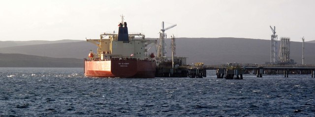
Sullom Voe Terminal

The Sullom Voe Terminal is an oil and gas terminal at Sullom Voe in the Shetland Islands of Scotland. It handles production from oilfields in the North...
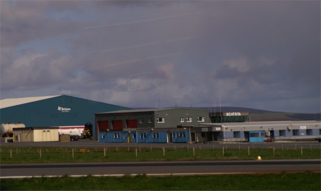
Scatsta Airport

Scatsta Airport (IATA: SCS, ICAO: EGPM), was a commercial airport on the island of Mainland, Shetland in Scotland located 17 nautical miles (31 km; 20...

Shetland Gas Plant

The Shetland Gas Plant is a natural-gas processing plant in the Shetland Islands, Scotland. == History == The Shetland Gas Plant is the collection and...

Punds Water

Punds Water is a freshwater loch near Mangaster in Northmavine, Shetland. It also gives its name to a nearby Neolithic heel-shaped cairn. == Heel-shaped... ==

Gunnister

Gunnister is a small 'abandoned' village at the North-West Mainland in Shetland, Scotland. It is most commonly known for the Gunnister Man - the remains...

Nearby Amenities

Located within 500m of 60.457119,-1.3242067
Seamark Light Category: upper
Seamark Light Character: Iso
Seamark Light Colour: white
Seamark Light Height: 45
Seamark Light Period: 4
Seamark Light Range: 14
Seamark Light Reference: A 3822.31
Seamark Type: light_minor
Source: US NGA Pub. 114. 2011-05-26.
Lat/Long: 60.4541833/-1.3287667
Seamark Light Category: upper
Seamark Light Character: Iso
Seamark Light Colour: white
Seamark Light Height: 45
Seamark Light Period: 4
Seamark Light Range: 14
Seamark Light Reference: A 3822.29
Seamark Type: light_minor
Source: US NGA Pub. 114. 2011-05-26.
Lat/Long: 60.4544833/-1.3298333
Seamark Information: Synchronized with rear lights
Seamark Light Category: lower
Seamark Light Character: Iso
Seamark Light Colour: white
Seamark Light Height: 27
Seamark Light Period: 4
Seamark Light Range: 14
Seamark Light Reference: A 3822.3
Seamark Type: light_minor
Source: US NGA Pub. 114. 2011-05-26.
Lat/Long: 60.45755/-1.3258833
The data included in this document is from www.openstreetmap.org. The data is made available under ODbL.

Have you been to Blanches Geo?

Leave your review of Blanches Geo below (or comments, questions and feedback).