Blobrick

Coastal Feature, Headland, Point in Shetland

Scotland

Blobrick

The Kame of Foula Britain's highest cliff (unless, like some, you think that the 'ledge' halfway down disqualifies it). It is, of course, impossible to take a meaningful photograph wholly within the square. In fact, it is probably impossible to stand up on two feet within the square!
The Kame of Foula Credit: Mike Pennington

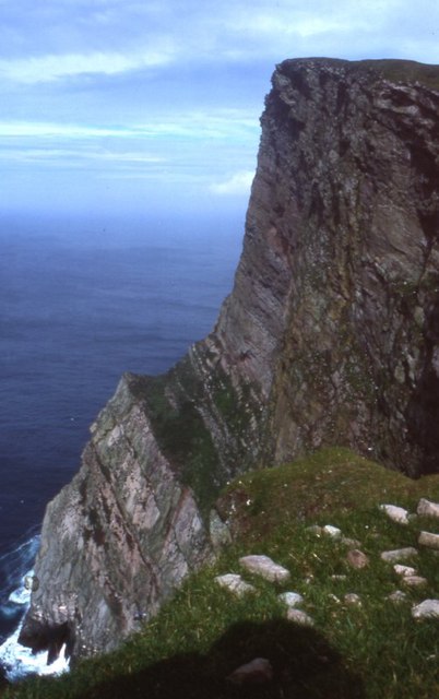
Blobrick is a prominent coastal feature located in the Shetland Islands, an archipelago off the northeast coast of mainland Scotland. It is classified as a headland or point due to its distinctive shape and geographical prominence.

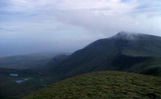
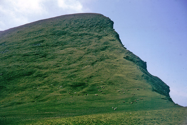
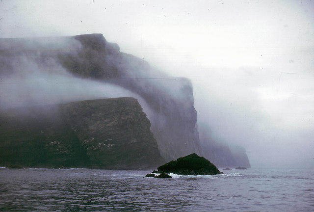
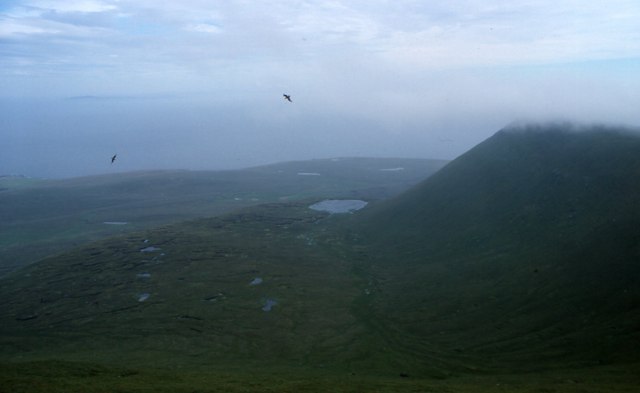
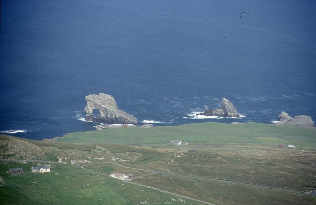
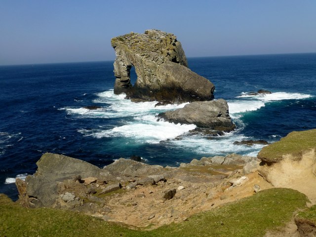
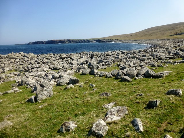
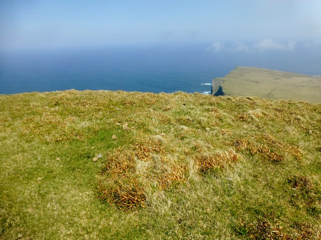
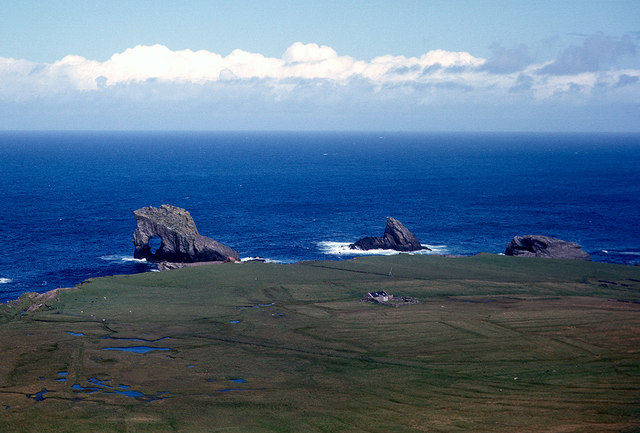
Situated on the western coast of the Mainland, the largest island in the Shetland group, Blobrick juts out into the North Atlantic Ocean. It is characterized by its steep cliffs, rugged terrain, and stunning panoramic views of the surrounding sea and landscape.

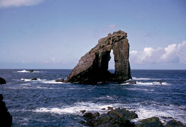
The headland is formed primarily of sedimentary rocks, including sandstone and shale, which have been shaped by centuries of erosion from the relentless waves and weather conditions. This erosion has resulted in the creation of sea caves, sea stacks, and natural arches that add to the scenic beauty of the area.

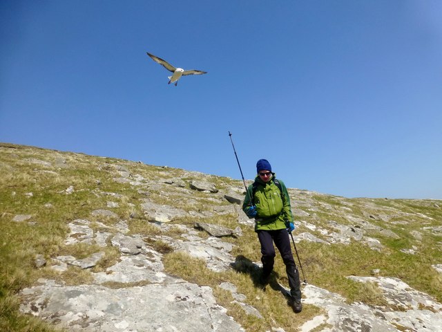
Blobrick is also known for its diverse wildlife population. The surrounding waters are home to a wide variety of marine species, including seals, dolphins, and numerous seabirds such as puffins and gannets. The adjacent grassy slopes and heathland provide habitat for nesting birds and grazing animals, including Shetland ponies and sheep.

The headland is a popular destination for hikers, nature enthusiasts, and photographers, who are drawn to its dramatic coastal scenery and abundant wildlife. A network of walking trails allows visitors to explore the area at their own pace, with opportunities to spot rare plants, wildflowers, and seabird colonies along the way.

Overall, Blobrick is a captivating coastal feature in the Shetland Islands, offering visitors a unique blend of rugged beauty, rich biodiversity, and awe-inspiring vistas of the North Atlantic.

If you have any feedback on the listing, please let us know in the comments section below.

Blobrick Images

Images are sourced within 2km of 60.152446/-2.0956054 or Grid Reference HT9440. Thanks to Geograph Open Source API. All images are credited.

The Kame of Foula Britain's highest cliff (unless, like some, you think that the 'ledge' halfway down disqualifies it). It is, of course, impossible to take a meaningful photograph wholly within the square. In fact, it is probably impossible to stand up on two feet within the square!
The Kame of Foula
Britain's highest cliff (unless, like some, you think that the 'ledge' halfway down disqualifies it). It is, of course, impossible to take a meaningful photograph wholly within the square. In fact, it is probably impossible to stand up on two feet within the square!
View from Da Kame to Da Sneug, Foula The highest hill on Foula and the second highest in Shetland. Taken from near da Kame. On the left are the Lochs o' da Fleck and the Loch o' Ouvrafandel is in the distance.
View from Da Kame to Da Sneug, Foula
The highest hill on Foula and the second highest in Shetland. Taken from near da Kame. On the left are the Lochs o' da Fleck and the Loch o' Ouvrafandel is in the distance.
Gaada Stack The stack has two separate arches.  This is the eastern arch.
Gaada Stack
The stack has two separate arches. This is the eastern arch.
Da Nort Bank On this slope the skuas attacked and the sheep tried to chase me over the cliff. It was the nesting season but both skuas and sheep meant business.
Da Nort Bank
On this slope the skuas attacked and the sheep tried to chase me over the cliff. It was the nesting season but both skuas and sheep meant business.
The cliffs of Foula The highest point, the Kame, is in the mist.
The cliffs of Foula
The highest point, the Kame, is in the mist.
The croft of Harrier 1964 The skuas did not attack if you were on the island road, but it was always useful to carry a long bonxie stick, and wave it in the air above your head when they sized you up.
The croft of Harrier 1964
The skuas did not attack if you were on the island road, but it was always useful to carry a long bonxie stick, and wave it in the air above your head when they sized you up.
Hiorawick and Strem Ness A storm prevented our leaving by boat or plane but created massive breakers in Hiorawick Bay
Hiorawick and Strem Ness
A storm prevented our leaving by boat or plane but created massive breakers in Hiorawick Bay
South Harrier Rough and improved grazings at South Harrier.  The hill at extreme left is The Kame, the second highest seacliffs in UK.
South Harrier
Rough and improved grazings at South Harrier. The hill at extreme left is The Kame, the second highest seacliffs in UK.
Hamnafield, Foula Hamnafield from the Sneug.
Hamnafield, Foula
Hamnafield from the Sneug.
The 1000 ft cliff of Nebbifield The near vertical face of Nebbifield viewed from below the top of the Kame
The 1000 ft cliff of Nebbifield
The near vertical face of Nebbifield viewed from below the top of the Kame
The base of the Nebbifield sea cliffs The lower section of the 1000 ft sea cliff
The base of the Nebbifield sea cliffs
The lower section of the 1000 ft sea cliff
Gaada Stack from Hamnafield, Foula The house on the left is North Harrier and further back towards the coast is Ristie.
Gaada Stack from Hamnafield, Foula
The house on the left is North Harrier and further back towards the coast is Ristie.
Gaada Stack, Foula Gaada Stack's three pillars tower over the rugged north coast of the island of Foula, with its stacks, steep-sided geos, and a storm beach called Da Stanes.
Gaada Stack, Foula
Gaada Stack's three pillars tower over the rugged north coast of the island of Foula, with its stacks, steep-sided geos, and a storm beach called Da Stanes.
Hiorawick Coastal View Foula (population: 30) is one of Britain's most remote inhabited islands and leaves a lasting impression on everyone who visits.  Foula's natural heritage is exceptionally rich and diverse for such a small area. The name means 'Bird Island' in Old Norse and Foula is designated as a Special Protection Area (SPA) for birds, a National Scenic Area and a Site of Special Scientific Interest (SSSI) for its plants, birds and geology.
Hiorawick Coastal View
Foula (population: 30) is one of Britain's most remote inhabited islands and leaves a lasting impression on everyone who visits. Foula's natural heritage is exceptionally rich and diverse for such a small area. The name means 'Bird Island' in Old Norse and Foula is designated as a Special Protection Area (SPA) for birds, a National Scenic Area and a Site of Special Scientific Interest (SSSI) for its plants, birds and geology.
Da Kame A super scenic spot today with Tricky Speirs.
Name: Da Kame
Hill number: 103797
Height: 376m / 1234ft
Area: 22: Shetland Islands
Class: 3
Grid ref: HT940400 (est)
Drop: 60m
Col: 316m  HT944397
Da Kame
A super scenic spot today with Tricky Speirs. Name: Da Kame Hill number: 103797 Height: 376m / 1234ft Area: 22: Shetland Islands Class: 3 Grid ref: HT940400 (est) Drop: 60m Col: 316m HT944397
Fulmars Attack This is one of a number of Fulmars that decided to attack Tricky Speirs and me as we descended beside Blobers Burn.
Fulmars Attack
This is one of a number of Fulmars that decided to attack Tricky Speirs and me as we descended beside Blobers Burn.
Skiordar Memorial And Seat A modest ridge in the N of the island of Foula in Shetland, Skiordar rises to around 75m (246 feet) 1¼ miles (2 km) north northwest of Ham. Extending out from the steep slopes characteristic of the west of the island, it is crossed by the road which runs to the north of the island. There is a memorial at its summit.
A great view today towards Gaada Stack.
Skiordar Memorial And Seat
A modest ridge in the N of the island of Foula in Shetland, Skiordar rises to around 75m (246 feet) 1¼ miles (2 km) north northwest of Ham. Extending out from the steep slopes characteristic of the west of the island, it is crossed by the road which runs to the north of the island. There is a memorial at its summit. A great view today towards Gaada Stack.
Ristie and the Foula stacks from the side of Soberlie Gaada Stack and da Sheepie are the prominent stacks.  Ristie is the isolated croft house.
Ristie and the Foula stacks from the side of Soberlie
Gaada Stack and da Sheepie are the prominent stacks. Ristie is the isolated croft house.
Show me another place!

Blobrick is located at Grid Ref: HT9440 (Lat: 60.152446, Lng: -2.0956054)

Unitary Authority: Shetland Islands

Police Authority: Highlands and Islands

What 3 Words

///shocking.published.strikers. Near Walls, Shetland Islands

Related Wikis

Foula

Foula (), located in the Shetland archipelago of Scotland, is one of the United Kingdom's most remote permanently inhabited islands. Owned since the turn...

Foula Airfield

Foula Airfield (IATA: FOA) is an airfield located on the remote island of Foula, part of the Shetland Islands in the north of Scotland. == History == The...

RMS Oceanic (1899)

Oceanic was a transatlantic ocean liner built for the White Star Line. She sailed on her maiden voyage on 6 September 1899 and was the largest ship in...

Nearby Amenities

Located within 500m of 60.152446,-2.0956054
North Bank
Place: locality
Source: npe
Lat/Long: 60.1486624/-2.1004917
Soberlie
Place: locality
Lat/Long: 60.1525062/-2.0892933
The data included in this document is from www.openstreetmap.org. The data is made available under ODbL.

Have you been to Blobrick?

Leave your review of Blobrick below (or comments, questions and feedback).