Dunnimaol

Coastal Feature, Headland, Point in Kincardineshire

Scotland

Dunnimaol

Downie Point This is the 'island' forming the end of Downie Point.  The flat topped island-like end of the headland isn't easily reachable on foot due to the steep gorge.
Downie Point Credit: Peter Robinson

Dunnimaol is a prominent coastal headland located in Kincardineshire, Scotland. Situated along the eastern coast of the country, it juts out into the North Sea, offering breathtaking views of the surrounding landscape.

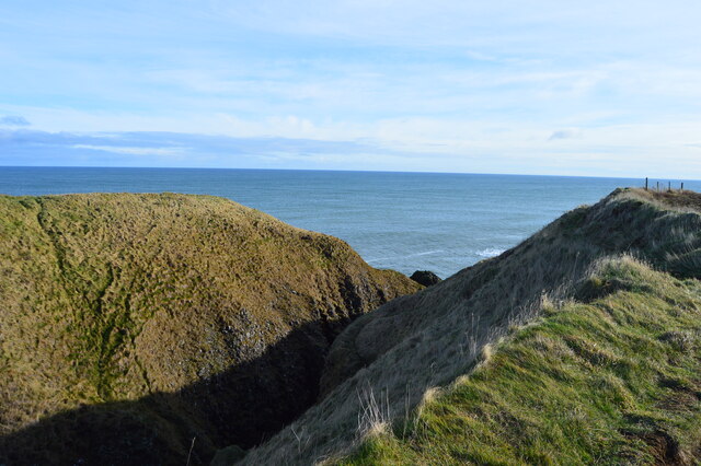
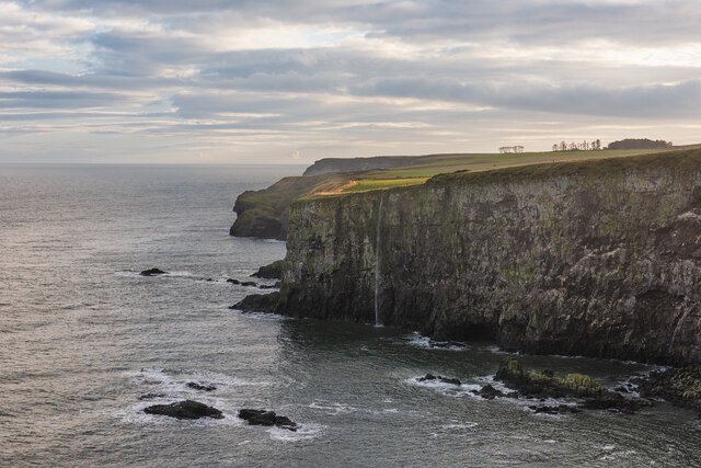
This headland is known for its rugged and rocky terrain, which has been sculpted by the relentless action of the sea over thousands of years. Dunnimaol is characterized by steep cliffs that rise dramatically from the water, reaching heights of up to 100 meters. These cliffs provide a nesting habitat for various seabird species, including guillemots, puffins, and gannets, making it a popular spot for birdwatching enthusiasts.

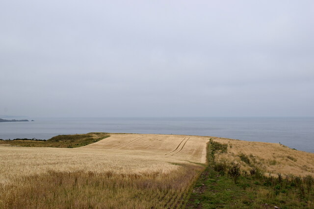
The headland is also home to a diverse range of flora and fauna, with several rare and protected species found in the area. The coastal grasslands surrounding Dunnimaol support a variety of wildflowers, such as sea campion and thrift, creating a colorful and vibrant landscape during the summer months.

Visitors to Dunnimaol can explore the headland by following a network of coastal paths and trails that offer stunning views of the coastline and the North Sea. The headland is also a popular destination for outdoor activities such as hiking and photography. Additionally, there are several viewpoints along the cliffs that provide excellent vantage points for spotting marine wildlife, including seals and dolphins.

Dunnimaol is a captivating coastal feature that showcases the natural beauty and rich biodiversity of Kincardineshire. Its stunning cliffs, diverse wildlife, and breathtaking views make it a must-visit destination for nature enthusiasts and those seeking a peaceful escape by the sea.

If you have any feedback on the listing, please let us know in the comments section below.

Dunnimaol Images

Images are sourced within 2km of 56.942463/-2.1963218 or Grid Reference NO8883. Thanks to Geograph Open Source API. All images are credited.

Downie Point This is the 'island' forming the end of Downie Point.  The flat topped island-like end of the headland isn't easily reachable on foot due to the steep gorge.
Downie Point
This is the 'island' forming the end of Downie Point. The flat topped island-like end of the headland isn't easily reachable on foot due to the steep gorge.
Dunnottar Castle Dunnottar Castle, near Stonehaven, Aberdeenshire.
Dunnottar Castle
Dunnottar Castle, near Stonehaven, Aberdeenshire.
Waterfall in Tremuda Bay The water from small burn draining the fields above forms the small but prominent waterfall.
Waterfall in Tremuda Bay
The water from small burn draining the fields above forms the small but prominent waterfall.
Boats, inner dock, Stonehaven harbour Mostly pleasure craft along with the Golden Harvest II (registered A99 (Aberdeen)) and the derelict looking INS31 fishing boats.
Boats, inner dock, Stonehaven harbour
Mostly pleasure craft along with the Golden Harvest II (registered A99 (Aberdeen)) and the derelict looking INS31 fishing boats.
Ella at rest The Ella (registered A11 (Aberdeen)) awaits her next fishing voyage while surrounded by pleasure craft in the inner dock at Stonehaven harbour.
Ella at rest
The Ella (registered A11 (Aberdeen)) awaits her next fishing voyage while surrounded by pleasure craft in the inner dock at Stonehaven harbour.
Inner dock, Stonehaven harbour Mostly pleasure craft, but the smartly turned-out Ella (A11) is prominent in the foreground.
Inner dock, Stonehaven harbour
Mostly pleasure craft, but the smartly turned-out Ella (A11) is prominent in the foreground.
No way through The coast road from Dunnottar to Stonehaven has been blocked off and traffic must now take the A92 and the A957 farther inland.
No way through
The coast road from Dunnottar to Stonehaven has been blocked off and traffic must now take the A92 and the A957 farther inland.
Stonehaven war memorial Despite its striking design as a 'Greek temple ruin', it only merits a C-listing by Historic Environment Scotland: LB2918 <span class="nowrap"><a title="http://portal.historicenvironment.scot/designation/LB2918" rel="nofollow ugc noopener" href="http://portal.historicenvironment.scot/designation/LB2918">Link</a><img style="margin-left:2px;" alt="External link" title="External link - shift click to open in new window" src="https://s1.geograph.org.uk/img/external.png" width="10" height="10"/></span> .
Stonehaven war memorial
Despite its striking design as a 'Greek temple ruin', it only merits a C-listing by Historic Environment Scotland: LB2918 LinkExternal link .
Looking towards Downie Point... ...from Stonehaven war memorial.  The sea and sky have merged into one as a haar (sea fog) starts to develop.
Looking towards Downie Point...
...from Stonehaven war memorial. The sea and sky have merged into one as a haar (sea fog) starts to develop.
Looking towards Strathlethan Bay... ...from Stonehaven war memorial.  The dark rocks in the background are part of the Dunnottar Castle conglomerate formation (interbedded conglomerate and sandstone), being sedimentary bedrock formed between 443.8 and 393.3 million years ago during the Silurian and Devonian periods.  The ruins of Dunnottar Castle can just be seen in the distance.
Looking towards Strathlethan Bay...
...from Stonehaven war memorial. The dark rocks in the background are part of the Dunnottar Castle conglomerate formation (interbedded conglomerate and sandstone), being sedimentary bedrock formed between 443.8 and 393.3 million years ago during the Silurian and Devonian periods. The ruins of Dunnottar Castle can just be seen in the distance.
Looking at Dunnottar Castle Yet another view caught in very strange light as a haar (sea fog) thickens.  The castle, which sits on an impregnable outcrop of conglomerate rock, is a scheduled monument and was designated as such as early as 1920: SM986 <span class="nowrap"><a title="http://portal.historicenvironment.scot/designation/SM986" rel="nofollow ugc noopener" href="http://portal.historicenvironment.scot/designation/SM986">Link</a><img style="margin-left:2px;" alt="External link" title="External link - shift click to open in new window" src="https://s1.geograph.org.uk/img/external.png" width="10" height="10"/></span> .
Looking at Dunnottar Castle
Yet another view caught in very strange light as a haar (sea fog) thickens. The castle, which sits on an impregnable outcrop of conglomerate rock, is a scheduled monument and was designated as such as early as 1920: SM986 LinkExternal link .
Dunnottar Lodge Typical sandstone construction: the sign below the window says 'purchase tickets at the castle'.
Dunnottar Lodge
Typical sandstone construction: the sign below the window says 'purchase tickets at the castle'.
Outbuildings at Mains of Dunnottar
Conglomerate rocks at Castle Haven Part of the Dunnottar Castle conglomerate formation (conglomerate and sandstone, interbedded): sedimentary bedrock formed between 443.8 and 393.3 million years ago during the Silurian and Devonian periods.
Conglomerate rocks at Castle Haven
Part of the Dunnottar Castle conglomerate formation (conglomerate and sandstone, interbedded): sedimentary bedrock formed between 443.8 and 393.3 million years ago during the Silurian and Devonian periods.
Walking the beach at Castle Haven Bay The cliffs are made up of conglomerate rock (<span class="nowrap"><a title="https://en.wikipedia.org/wiki/Conglomerate_(geology)" rel="nofollow ugc noopener" href="https://en.wikipedia.org/wiki/Conglomerate_(geology)">Link</a><img style="margin-left:2px;" alt="External link" title="External link - shift click to open in new window" src="https://s1.geograph.org.uk/img/external.png" width="10" height="10"/></span> ), which consist of rounded clasts of rock embedded in a matrix of hardened sediment.
Walking the beach at Castle Haven Bay
The cliffs are made up of conglomerate rock (LinkExternal link ), which consist of rounded clasts of rock embedded in a matrix of hardened sediment.
Conglomerate cliffs at Bowdun Head
Crops growing above Downie Point
Welcome to Stonehaven The sign on the now-closed coastal road notes the town's most famous son and displays the burgh arms: Per fess: in chief paly of six or and gules, in base azure.  The town was made a burgh of barony in 1587 but the arms were not granted by Lord Lyon until 1929.  The arms are inspired by the Keith arms (argent, a chief gules three pallets or) but the tincture (colour) of the lower part of the shield is changed from silver to blue, to emphasise Stonehaven's status as a seaport.
Welcome to Stonehaven
The sign on the now-closed coastal road notes the town's most famous son and displays the burgh arms: Per fess: in chief paly of six or and gules, in base azure. The town was made a burgh of barony in 1587 but the arms were not granted by Lord Lyon until 1929. The arms are inspired by the Keith arms (argent, a chief gules three pallets or) but the tincture (colour) of the lower part of the shield is changed from silver to blue, to emphasise Stonehaven's status as a seaport.
Show me another place!

Dunnimaol is located at Grid Ref: NO8883 (Lat: 56.942463, Lng: -2.1963218)

Unitary Authority: Aberdeenshire

Police Authority: North East

What 3 Words

///gallons.snowballs.probe. Near Stonehaven, Aberdeenshire

Related Wikis

Dunnottar Castle

Dunnottar Castle (Scottish Gaelic: Dùn Fhoithear, "fort on the shelving slope") is a ruined medieval fortress located upon a rocky headland on the north...

Bowdun Head

Bowdun Head is a headland landform on the North Sea coast approximately one kilometre south of Stonehaven, Scotland.(Ordnance Survey, 2004) Slightly to...

Thornyhive Bay

Thornyhive Bay is an embayment along the North Sea coast in Aberdeenshire, Scotland. This bay is situated approximately 2.5 miles south of the town of...

Dunnicaer

Dunnicaer, or Dun-na-caer, is a precipitous sea stack just off the coast of Aberdeenshire, Scotland, between Dunnottar Castle and Stonehaven. Despite the...

Nearby Amenities

Located within 500m of 56.942463,-2.1963218
Created By: almien_coastlines
Source: PGS
Lat/Long: 56.938509/-2.199462
Source: PGS
Lat/Long: 56.9390483/-2.1979821
Created By: almien_coastlines
Source: PGS
Lat/Long: 56.938882/-2.197814
Source: PGS
Lat/Long: 56.9387595/-2.1976664
Source: PGS
Lat/Long: 56.9384374/-2.1971831
Source: PGS
Lat/Long: 56.9381845/-2.1960166
Created By: almien_coastlines
Source: PGS
Lat/Long: 56.938488/-2.196184
Source: PGS
Lat/Long: 56.9391831/-2.1966676
Source: PGS
Lat/Long: 56.9392619/-2.1968079
Source: PGS
Lat/Long: 56.9394331/-2.1964543
Source: PGS
Lat/Long: 56.9396789/-2.1959493
Created By: almien_coastlines
Source: PGS
Lat/Long: 56.94028/-2.196145
Created By: almien_coastlines
Source: PGS
Lat/Long: 56.940536/-2.19614
Source: PGS
Lat/Long: 56.9410441/-2.1960206
Source: PGS
Lat/Long: 56.9410567/-2.1972472
Source: PGS
Lat/Long: 56.94127/-2.1965257
Source: PGS
Lat/Long: 56.9414131/-2.1960826
Source: PGS
Lat/Long: 56.9416901/-2.1957481
Source: PGS
Lat/Long: 56.9428894/-2.1964114
Source: PGS
Lat/Long: 56.9430605/-2.1968057
Created By: almien_coastlines
Source: PGS
Lat/Long: 56.943358/-2.197016
Source: PGS
Lat/Long: 56.9437141/-2.1975004
Source: PGS
Lat/Long: 56.943725/-2.198153
Source: PGS
Lat/Long: 56.9437949/-2.1992524
Source: PGS
Lat/Long: 56.9445845/-2.1993626
Source: PGS
Lat/Long: 56.9452025/-2.1956944
Source: PGS
Lat/Long: 56.9459969/-2.1948363
Source: PGS
Lat/Long: 56.9462669/-2.1941543
Source: PGS
Lat/Long: 56.9466824/-2.1955115
Source: PGS
Lat/Long: 56.9467082/-2.1966187
Source: PGS
Lat/Long: 56.9466304/-2.1973006
Source: PGS
Lat/Long: 56.9466455/-2.1976066
Source: PGS
Lat/Long: 56.9467036/-2.1977756
Source: PGS
Lat/Long: 56.9468001/-2.1977756
Turning Circle
Lat/Long: 56.9457103/-2.2020173
Entrance: yes
Lat/Long: 56.9460419/-2.1962531
Tourism: viewpoint
Lat/Long: 56.9453355/-2.1998793
Source: PGS
Lat/Long: 56.9464246/-2.1978614
Source: PGS
Lat/Long: 56.9466867/-2.1961247
Source: PGS
Lat/Long: 56.9466615/-2.1961057
Source: PGS
Lat/Long: 56.9466838/-2.1960679
Source: PGS
Lat/Long: 56.9464498/-2.1949778
Source: PGS
Lat/Long: 56.9465127/-2.1952674
Source: PGS
Lat/Long: 56.9460516/-2.1947404
Source: PGS
Lat/Long: 56.9458536/-2.1952552
Source: PGS
Lat/Long: 56.9454542/-2.1952674
Source: PGS
Lat/Long: 56.945384/-2.1952352
Source: PGS
Lat/Long: 56.9451087/-2.1965655
Source: PGS
Lat/Long: 56.9453589/-2.1978328
Dunnottar Castle
Check Date: 2023-06-25
Opening Hours: Mo-Su 09:00-18:00
Shop: ticket
Lat/Long: 56.9460734/-2.1981169
Life Ring
Emergency: life_ring
Lat/Long: 56.9460981/-2.196337
Entrance: yes
Lat/Long: 56.9460429/-2.1958239
Entrance: yes
Lat/Long: 56.9460275/-2.1960656
Entrance: yes
Lat/Long: 56.9458985/-2.1963077
Waterway: waterfall
Lat/Long: 56.9455009/-2.2017181
Waterway: waterfall
Lat/Long: 56.9453739/-2.2012027
Barack Room
Historic: yes
Indoor: room
Ruins: yes
Start Date: c16
Lat/Long: 56.9460242/-2.1982815
Bench
Colour: brown
Material: wood
Seats: 4
Lat/Long: 56.9463099/-2.1998986
Bench
Lat/Long: 56.9462233/-2.2006988
Bench
Lat/Long: 56.9459237/-2.2008496
Toilets
Opening Hours: Mo-Su 09:00-18:00
Lat/Long: 56.9458012/-2.1971952
Direction: E
Tourism: viewpoint
Lat/Long: 56.9459734/-2.2006345
Entrance: yes
Lat/Long: 56.9462594/-2.1965097
The data included in this document is from www.openstreetmap.org. The data is made available under ODbL.

Have you been to Dunnimaol?

Leave your review of Dunnimaol below (or comments, questions and feedback).