Maiden's Rock
Coastal Feature, Headland, Point in Fife
Scotland
Maiden's Rock

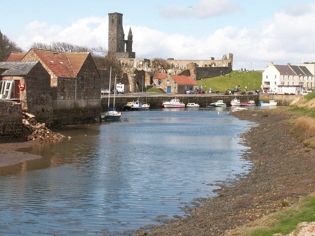
Maiden's Rock is a prominent coastal feature located in Fife, Scotland. This headland, also known as Maiden's Point, is a significant landmark along the Fife coastline. Situated near the town of St. Andrews, it extends into the North Sea, offering stunning views and a captivating atmosphere.
The rock earned its name from a local legend that dates back centuries. According to the tale, a young maiden was imprisoned on the rock, awaiting her execution. As the tide rose, she leaped into the sea, choosing death over her impending fate. The rock stands as a somber reminder of this tragic event.
Physically, Maiden's Rock is a rugged and imposing structure. It juts out into the sea, forming a natural promontory that attracts both locals and tourists. The rock is composed of solid sandstone, displaying intricate patterns and layers, which have been shaped by the relentless force of the crashing waves over time. This geological feature adds to its allure.
The headland offers stunning panoramic views of the surrounding coastline. On clear days, visitors can see as far as the Isle of May and the East Neuk of Fife. The rugged cliffs and the sound of the crashing waves below create a dramatic and awe-inspiring setting.
Maiden's Rock has become a popular destination for nature enthusiasts, hikers, and photographers, who are drawn to its natural beauty and historical significance. It stands as a testament to the rich cultural heritage and captivating landscapes that Fife has to offer.
If you have any feedback on the listing, please let us know in the comments section below.
Maiden's Rock Images
Images are sourced within 2km of 56.332139/-2.7674642 or Grid Reference NO5215. Thanks to Geograph Open Source API. All images are credited.


![St. Andrews Cathedral, remains of the West Front This must be a heart-breaking scene for anyone with an interest in Scottish history or a love of and respect for old buildings. It's all too easy to blame the Protestant reformers for the appalling condition of the Cathedral today - and I suppose they bear responsibility for its loss of protection in the post-Reformation era - but their iconoclastic attack in 1559 could never have wrought damage to the extent seen here. This is clearly a result of not just neglect but the subsequent quarrying of the stone over generations for use in the town and surrounding area. Destruction in war apart, this must qualify as one of the worst acts of vandalism ever perpetrated on a church building in the whole of western Europe.
Between 1273 and 1279 the west front was wrecked in a storm and rebuilt under Bishop Wishart (1271-79) who was buried in front of the high altar. The new front, seen here, was built two bays further east of the original gable. The central door was the main processional doorway used by the canons, while parishioners and pilgrims entered by a door on the north side of the nave.
"..the tacit assumption that all ecclesiastical buildings of Scotland were in fair or good condition when that outburst [of 1559-60] took place is preposterous". -- David Hay Fleming, Reformation in Scotland, 1931](https://s0.geograph.org.uk/geophotos/02/67/78/2677872_eeec8993.jpg)


Maiden's Rock is located at Grid Ref: NO5215 (Lat: 56.332139, Lng: -2.7674642)
Unitary Authority: Fife
Police Authority: Fife
What 3 Words
///splashes.bumps.irrigated. Near St Andrews, Fife
Nearby Locations
Related Wikis

St Nicholas Hospital, St Andrews
St Nicholas Hospital was a medieval hospital in St Andrews, Fife. It was located around what is today St Nicholas farmhouse at the Steading, between Albany...
Kinkell, Fife
Kinkell was an estate to the east of St Andrews in Scotland. In the Middle Ages it was the site of a chapel, hospital, dovecote and a castle or manor house...
Kinness Burn
The Kinness Burn is a 5+3⁄4 miles (9.5 kilometres) long burn (stream) in Fife, Scotland. It flows into the North Sea through the inner harbour of St Andrews...

Church of St Mary on the Rock
The Church of St Mary on the Rock or St Mary's Collegiate Church, was a secular college of priests based on the seaward side of St Andrews Cathedral, St...
St Andrews Cathedral Priory
St Andrews Cathedral Priory was a priory of Augustinian canons in St Andrews, Fife, Scotland. It was one of the great religious houses in Scotland, and...
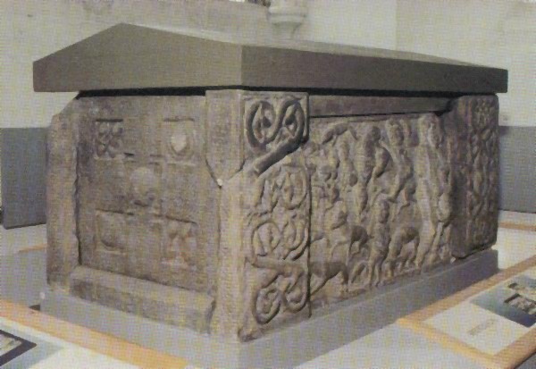
St Andrews Sarcophagus
The Saint Andrews Sarcophagus is a Pictish monument dating from the second half of the 8th century. The sarcophagus was recovered beginning in 1833 during...
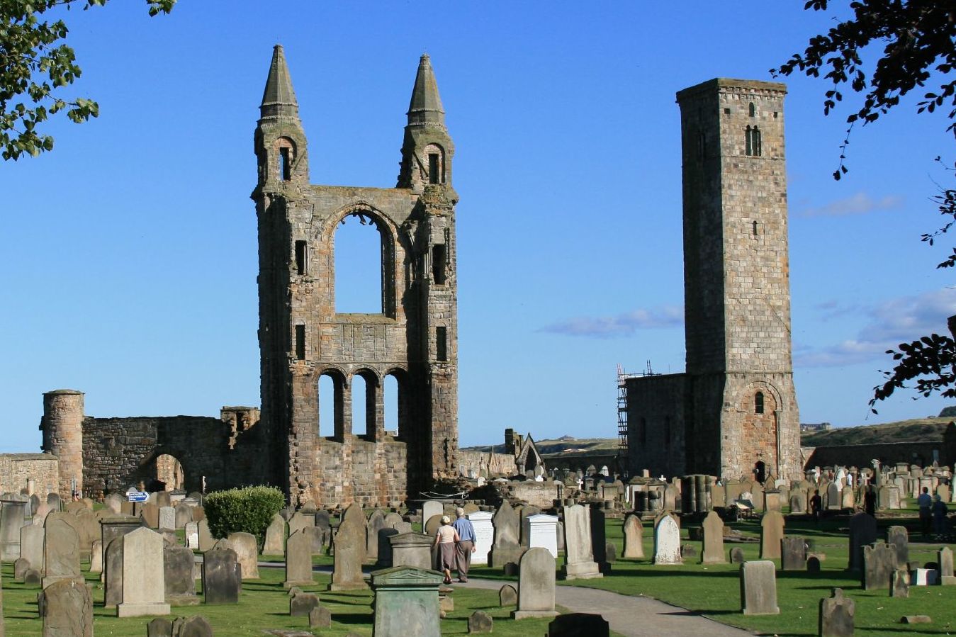
St Andrews Cathedral
The Cathedral of St Andrew (often referred to as St Andrews Cathedral) is a ruined cathedral in St Andrews, Fife, Scotland. It was built in 1158 and became...

St Leonards School
St Leonards School is a private boarding and day school for pupils aged 4–19 in St Andrews, Fife, Scotland. Founded in 1877 as St Andrews School for Girls...
Nearby Amenities
Located within 500m of 56.332139,-2.7674642Have you been to Maiden's Rock?
Leave your review of Maiden's Rock below (or comments, questions and feedback).