Brownhills

Settlement in Fife

Scotland

Brownhills

South Street, St Andrews
South Street, St Andrews Credit: Richard Webb

Brownhills is a small village located in the eastern part of Fife, Scotland. Situated approximately 4 miles southeast of the town of Glenrothes, it is nestled in a rural setting surrounded by picturesque countryside. The village is characterized by its tranquil atmosphere and offers a peaceful retreat from the hustle and bustle of nearby urban areas.

Brownhills has a rich history dating back centuries, with evidence of human settlement in the area since ancient times. The village is known for its traditional architecture, with many buildings constructed using locally sourced materials, such as sandstone and slate.

Despite its small size, Brownhills boasts a close-knit community that takes pride in its heritage. The village features a small primary school, which serves the local children, and a community center that hosts various events and activities throughout the year. Additionally, there is a village pub where residents and visitors can gather for a drink and a meal, fostering a sense of camaraderie among the locals.

The surrounding countryside offers ample opportunities for outdoor pursuits, including walking, hiking, and cycling. Nearby attractions include the Lomond Hills Regional Park, which provides breathtaking views and a range of recreational activities.

Overall, Brownhills is a charming village that offers a peaceful and idyllic lifestyle for its residents. With its rich history, beautiful surroundings, and strong sense of community, it is a hidden gem in the heart of Fife.

If you have any feedback on the listing, please let us know in the comments section below.

Brownhills Images

Images are sourced within 2km of 56.324941/-2.7777332 or Grid Reference NO5215. Thanks to Geograph Open Source API. All images are credited.
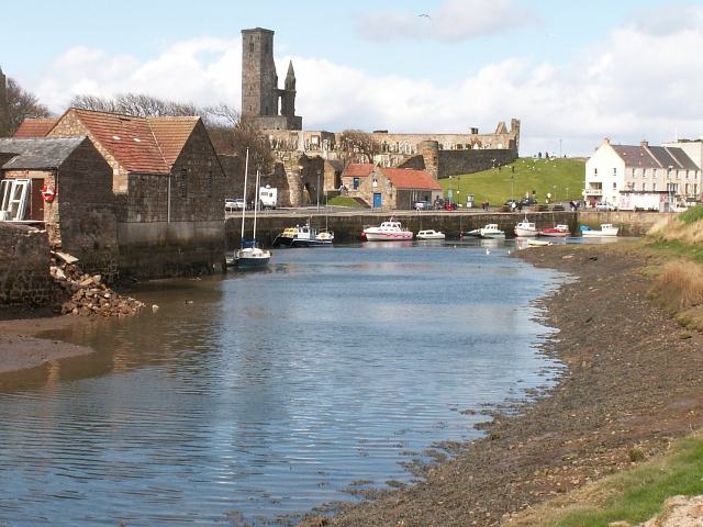
South Street, St Andrews
Department of Medieval History, St Andrews University Ornate doorway in South Street.
Department of Medieval History, St Andrews University
Ornate doorway in South Street.
Abbey Street Maps are not too forthcoming on the name of this street so assumptions have been made. Looking towards the castle.
Abbey Street
Maps are not too forthcoming on the name of this street so assumptions have been made. Looking towards the castle.
The Fulmar One of several fishing boats moored in St Andrews harbour
The Fulmar
One of several fishing boats moored in St Andrews harbour
Arctic Tern and Solaris Fishing boats moored in St Andrews harbour
Arctic Tern and Solaris
Fishing boats moored in St Andrews harbour
Samuel Rutherford's Grave, St Andrews Cathedral After losing his charge as minister at Anwoth in Galloway, due to his nonconformity to Episcopacy, Samuel Rutherford was banished to Aberdeen. In 1638 he became the Professor of Divinity at St Andrews University. The inscription reads (note unusual spelling of Samuel Rutherford):

                                 M
                                                                                                            S    .   R
                 Here lyes the Reverend Mr. Samuell
               Rutherfoord Professor of Divinity in
               The University of St Andrews who died
               March the 20 1661.
               What tongu what Pen or Skill of Men
               Can famous Rutherfoord commend
               His Learning justly rasid his fame                     
               True GODliness Adornd His Name
               He did converse with things ABOVE
               Acquainted with Emmanuels Love
               Most orthodox He was And sound
               And Many Errots Did confound
               For Zions King and Zions cause
               And Scotlands covenanted Laws
               Most constantly he Did contend
               Until His Time was At An End
               Than He wan To the Full Fruition
               Of That which He Had seen in vision.
Samuel Rutherford's Grave, St Andrews Cathedral
After losing his charge as minister at Anwoth in Galloway, due to his nonconformity to Episcopacy, Samuel Rutherford was banished to Aberdeen. In 1638 he became the Professor of Divinity at St Andrews University. The inscription reads (note unusual spelling of Samuel Rutherford): M S . R Here lyes the Reverend Mr. Samuell Rutherfoord Professor of Divinity in The University of St Andrews who died March the 20 1661. What tongu what Pen or Skill of Men Can famous Rutherfoord commend His Learning justly rasid his fame True GODliness Adornd His Name He did converse with things ABOVE Acquainted with Emmanuels Love Most orthodox He was And sound And Many Errots Did confound For Zions King and Zions cause And Scotlands covenanted Laws Most constantly he Did contend Until His Time was At An End Than He wan To the Full Fruition Of That which He Had seen in vision.
Grounds of St. Mary's College, South Street, St. Andrews The college is part of the University of St. Andrews, and the School of Divinity is based here. The arch hidden under the vegetation is apparently a kind of folly, and not part of some ancient wall. It seems the vegetation was removed at some stage, but this photo was taken a long while ago!

The arch and the garden in front and behind is in OS square NO5016. Immediately to the right everything, including the college buildings, are in NO5116.
Grounds of St. Mary's College, South Street, St. Andrews
The college is part of the University of St. Andrews, and the School of Divinity is based here. The arch hidden under the vegetation is apparently a kind of folly, and not part of some ancient wall. It seems the vegetation was removed at some stage, but this photo was taken a long while ago! The arch and the garden in front and behind is in OS square NO5016. Immediately to the right everything, including the college buildings, are in NO5116.
Feeding the doves of St. Mary's College, South Street, St. Andrews Sadly this is a sight you are unlikely to ever see again. The quadrangle of St. Mary's College used to be home to a large number of doves, which were fed by the college. The doves were long regarded as the mascot of the College. This photograph shows a gentleman in a smart uniform feeding them. Look closely and you will see some opportunistic pigeons amongst the doves. The doves are no longer here. The official website has a brief note that the doves had "to be removed for health reasons". It doesn't explain whether this was for the health of the doves, or the students and staff, nor where the doves were removed to. This seems to have happened about 1994. However we can probably assume that the pigeons are still around.
Feeding the doves of St. Mary's College, South Street, St. Andrews
Sadly this is a sight you are unlikely to ever see again. The quadrangle of St. Mary's College used to be home to a large number of doves, which were fed by the college. The doves were long regarded as the mascot of the College. This photograph shows a gentleman in a smart uniform feeding them. Look closely and you will see some opportunistic pigeons amongst the doves. The doves are no longer here. The official website has a brief note that the doves had "to be removed for health reasons". It doesn't explain whether this was for the health of the doves, or the students and staff, nor where the doves were removed to. This seems to have happened about 1994. However we can probably assume that the pigeons are still around.
St Leonard's School St Leonard's is an independent school which originally took girls only. This is the south wing of the main school building, with the school tower behind it. From the street, the school presents a rather forbidding aspect, but it has extensive gardens and playing fields inside the grim-looking walls.
St Leonard's School
St Leonard's is an independent school which originally took girls only. This is the south wing of the main school building, with the school tower behind it. From the street, the school presents a rather forbidding aspect, but it has extensive gardens and playing fields inside the grim-looking walls.
Slipway, St Andrews Small wooden slipway at East Sands.
Slipway, St Andrews
Small wooden slipway at East Sands.
Lifebuoy, St Andrews The lifebuoy is near the slipway at East Sands.  The ruins of St Andrews Cathedral can be seen in the distance.
Lifebuoy, St Andrews
The lifebuoy is near the slipway at East Sands. The ruins of St Andrews Cathedral can be seen in the distance.
The Pends, St. Andrews These arched gateways, known as the Pends, stand astride the road to the south and allowed the Augustinian canons of St. Andrews to control traffic to and from the priory and the harbour.
The Pends, St. Andrews
These arched gateways, known as the Pends, stand astride the road to the south and allowed the Augustinian canons of St. Andrews to control traffic to and from the priory and the harbour.
Tower of St. Rule's Church Pilgrimages to St. Andrews were encouraged in the 12th century by Queen Margaret, the Anglo-Saxon wife of Malcolm Canmore (r.1057-93), who was canonised in 1251. Her confessor and biographer, Turgot, bishop of Durham, became the first bishop of the revived diocese of St Andrews at the head of a community of Celtic, or Culdee monks (from the Gaelic 'Cele De', meaning 'servant of God'). The foundations of a later church, built on what may have been the site of their church, can still be seen to the north of the cathedral on the cliffs overlooking the harbour.

By the end of the reign of Margaret's son, Alexander I (r.1107-24), attempts were made to establish Roman church organisation by introducing a community of Augustinian canons who founded a priory. This tower is the only surviving part of their first church which may well have been built to house the relics of Andrew. A pre-Norman structure, it was built in two stages, probably in the 1120s and the 1140s, and has come to be popularly associated with St Rule. No trace remains of the nave which was added at a later stage. The tower is 32.92 metres (108 ft) high and offers a spectacular view of the adjacent burgh and surrounding countryside. The staircase dates from the 16th century.
Tower of St. Rule's Church
Pilgrimages to St. Andrews were encouraged in the 12th century by Queen Margaret, the Anglo-Saxon wife of Malcolm Canmore (r.1057-93), who was canonised in 1251. Her confessor and biographer, Turgot, bishop of Durham, became the first bishop of the revived diocese of St Andrews at the head of a community of Celtic, or Culdee monks (from the Gaelic 'Cele De', meaning 'servant of God'). The foundations of a later church, built on what may have been the site of their church, can still be seen to the north of the cathedral on the cliffs overlooking the harbour. By the end of the reign of Margaret's son, Alexander I (r.1107-24), attempts were made to establish Roman church organisation by introducing a community of Augustinian canons who founded a priory. This tower is the only surviving part of their first church which may well have been built to house the relics of Andrew. A pre-Norman structure, it was built in two stages, probably in the 1120s and the 1140s, and has come to be popularly associated with St Rule. No trace remains of the nave which was added at a later stage. The tower is 32.92 metres (108 ft) high and offers a spectacular view of the adjacent burgh and surrounding countryside. The staircase dates from the 16th century.
Cathedral precinct wall, St. Andrews The cathedral's remarkably well-preserved boundary wall, fortified by a series of round and rectangular towers, dates from the 16th century. It is one mile long and encloses an area of over 12 hectares.
Cathedral precinct wall, St. Andrews
The cathedral's remarkably well-preserved boundary wall, fortified by a series of round and rectangular towers, dates from the 16th century. It is one mile long and encloses an area of over 12 hectares.
Cathedral archway, St. Andrews
St. Andrews Cathedral, remains of the West Front This must be a heart-breaking scene for anyone with an interest in Scottish history or a love of and respect for old buildings. It's all too easy to blame the Protestant reformers for the appalling condition of the Cathedral today - and I suppose they bear responsibility for its loss of protection in the post-Reformation era - but their iconoclastic attack in 1559 could never have wrought damage to the extent seen here. This is clearly a result of not just neglect but the subsequent quarrying of the stone over generations for use in the town and surrounding area. Destruction in war apart, this must qualify as one of the worst acts of vandalism ever perpetrated on a church building in the whole of western Europe.

Between 1273 and 1279 the west front was wrecked in a storm and rebuilt under Bishop Wishart (1271-79) who was buried in front of the high altar. The new front, seen here, was built two bays further east of the original gable. The central door was the main processional doorway used by the canons, while parishioners and pilgrims entered by a door on the north side of the nave.

"..the tacit assumption that all ecclesiastical buildings of Scotland were in fair or good condition when that outburst [of 1559-60] took place is preposterous". -- David Hay Fleming, Reformation in Scotland, 1931
St. Andrews Cathedral, remains of the West Front
This must be a heart-breaking scene for anyone with an interest in Scottish history or a love of and respect for old buildings. It's all too easy to blame the Protestant reformers for the appalling condition of the Cathedral today - and I suppose they bear responsibility for its loss of protection in the post-Reformation era - but their iconoclastic attack in 1559 could never have wrought damage to the extent seen here. This is clearly a result of not just neglect but the subsequent quarrying of the stone over generations for use in the town and surrounding area. Destruction in war apart, this must qualify as one of the worst acts of vandalism ever perpetrated on a church building in the whole of western Europe. Between 1273 and 1279 the west front was wrecked in a storm and rebuilt under Bishop Wishart (1271-79) who was buried in front of the high altar. The new front, seen here, was built two bays further east of the original gable. The central door was the main processional doorway used by the canons, while parishioners and pilgrims entered by a door on the north side of the nave. "..the tacit assumption that all ecclesiastical buildings of Scotland were in fair or good condition when that outburst [of 1559-60] took place is preposterous". -- David Hay Fleming, Reformation in Scotland, 1931
Ruins of St. Andrews Cathedral The Cathedral, founded about 1160 in the reign of Queen Margaret's great-grandson, Malcolm IV (r.1153-65), was intended to be the longest church in Scotland, having an interior measuring 109 metres from east to west. In 1192 the claim of the Archbishop of York to supremacy over the affairs of the Scottish church was finally rejected when a papal bull recognised the latter (excepting Galloway) as "a special daughter" of Rome. Thereafter, St. Andrews, as the richest church in the kingdom enjoying the revenues of over two hundred parish kirks, assumed the leadership of Scottish ecclesiastical affairs. In 1472, it became the metropolitan church in Scotland (including Orkney and the Isles, previously under Trondheim) when its bishops were elevated to archbishops.
Ruins of St. Andrews Cathedral
The Cathedral, founded about 1160 in the reign of Queen Margaret's great-grandson, Malcolm IV (r.1153-65), was intended to be the longest church in Scotland, having an interior measuring 109 metres from east to west. In 1192 the claim of the Archbishop of York to supremacy over the affairs of the Scottish church was finally rejected when a papal bull recognised the latter (excepting Galloway) as "a special daughter" of Rome. Thereafter, St. Andrews, as the richest church in the kingdom enjoying the revenues of over two hundred parish kirks, assumed the leadership of Scottish ecclesiastical affairs. In 1472, it became the metropolitan church in Scotland (including Orkney and the Isles, previously under Trondheim) when its bishops were elevated to archbishops.
North wall of the cloister, St. Andrews Cathedral The blocked-up doorway at the west end of the south wall was the day-time entrance used by the canons to process into the church from the cloister. The cloister garth may well have been laid out as a herb garden.

"The old church here was a noble structure; it was longer than St Paul's in London, by a considerable deal, I think, by six yards, or by twenty-five foot. This building is now sunk into a simple parish church, though there are many plain discoveries of what it has been, and a great deal of project and fancy may be employed to find out the ancient shape of it." -- Daniel Defoe, A Tour Thro' The Whole Island of Great Britain, 1724-6
North wall of the cloister, St. Andrews Cathedral
The blocked-up doorway at the west end of the south wall was the day-time entrance used by the canons to process into the church from the cloister. The cloister garth may well have been laid out as a herb garden. "The old church here was a noble structure; it was longer than St Paul's in London, by a considerable deal, I think, by six yards, or by twenty-five foot. This building is now sunk into a simple parish church, though there are many plain discoveries of what it has been, and a great deal of project and fancy may be employed to find out the ancient shape of it." -- Daniel Defoe, A Tour Thro' The Whole Island of Great Britain, 1724-6
Show me another place!

Brownhills is located at Grid Ref: NO5215 (Lat: 56.324941, Lng: -2.7777332)

Unitary Authority: Fife

Police Authority: Fife

What 3 Words

///belonging.blackbird.displays. Near St Andrews, Fife

Related Wikis

St Nicholas Hospital, St Andrews

St Nicholas Hospital was a medieval hospital in St Andrews, Fife. It was located around what is today St Nicholas farmhouse at the Steading, between Albany...

Kinkell, Fife

Kinkell was an estate to the east of St Andrews in Scotland. In the Middle Ages it was the site of a chapel, hospital, dovecote and a castle or manor house...

St Andrews Community Hospital

St Andrews Community Hospital is a small hospital to the south of the university town of St Andrews in Fife, Scotland. The hospital serves the town of...

Kinness Burn

The Kinness Burn is a 5+3⁄4 miles (9.5 kilometres) long burn (stream) in Fife, Scotland. It flows into the North Sea through the inner harbour of St Andrews...

Church of St Mary on the Rock

The Church of St Mary on the Rock or St Mary's Collegiate Church, was a secular college of priests based on the seaward side of St Andrews Cathedral, St...

St Andrews Cathedral Priory

St Andrews Cathedral Priory was a priory of Augustinian canons in St Andrews, Fife, Scotland. It was one of the great religious houses in Scotland, and...

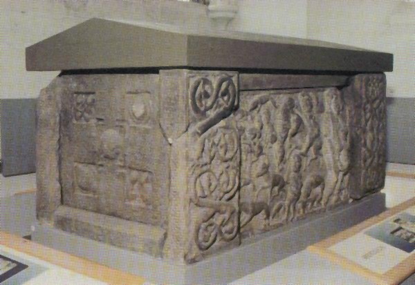
St Andrews Sarcophagus

The Saint Andrews Sarcophagus is a Pictish monument dating from the second half of the 8th century. The sarcophagus was recovered beginning in 1833 during...

St Leonards School

St Leonards School is a private boarding and day school for pupils aged 4–19 in St Andrews, Fife, Scotland. Founded in 1877 as St Andrews School for Girls...

Nearby Amenities

Located within 500m of 56.324941,-2.7777332
Brownhills Garage
Addr Housename: Brownhills Garage
Addr Postcode: KY16 8PL
Addr Street: St Andrews
Shop: car_repair
Website: https://brownhillsgarage.co.uk/
Lat/Long: 56.3269866/-2.7705974
Restaurant
The Grange Inn
Addr City: St Andrews
Addr Postcode: KY16 8LJ
Addr Street: Grange Road
Fhrs Id: 106731
Source Addr: FHRS Open Data
Lat/Long: 56.3206238/-2.7797662
Post Box
Post Box Type: lamp
Ref: KY16 203
Royal Cypher: scottish_crown
Lat/Long: 56.3290647/-2.7745782
Balmungo Cottage
Addr City: St Andrews
Addr Country: GB
Addr Housename: Balmungo Cottage
Addr Postcode: KY16 8LW
Fhrs Id: 860767
Guest House: bed_and_breakfast
Tourism: guest_house
Lat/Long: 56.3217399/-2.7763787
Cables: 3
Description: Remotely controlled disconnector
Power: switch
Switch: disconnector
Lat/Long: 56.3254504/-2.7815413
Description: Manually operated disconnector
Power: switch
Switch: disconnector
Lat/Long: 56.3255376/-2.7804565
Power: pole
Lat/Long: 56.3256391/-2.7793856
Power: pole
Lat/Long: 56.3257355/-2.7783307
Power: pole
Lat/Long: 56.3255488/-2.7770799
Power: pole
Lat/Long: 56.3253501/-2.7756973
Power: pole
Lat/Long: 56.3251524/-2.7743704
Power: pole
Lat/Long: 56.3249547/-2.7730088
Power: pole
Lat/Long: 56.3247582/-2.7716652
Power: pole
Lat/Long: 56.3245843/-2.7703425
Location Transition: yes
Power: pole
Lat/Long: 56.3254376/-2.7816691
Power: pole
Lat/Long: 56.3231456/-2.7808143
Power: pole
Lat/Long: 56.3230436/-2.7823046
Power: pole
Lat/Long: 56.3229393/-2.7837673
Power: pole
Lat/Long: 56.3219313/-2.7765296
Power: pole
Lat/Long: 56.3223685/-2.7763837
Power: pole
Lat/Long: 56.3227787/-2.7762569
Power: pole
Lat/Long: 56.3232734/-2.7761258
Power: pole
Lat/Long: 56.3235395/-2.7763626
Power: pole
Lat/Long: 56.3240095/-2.7767705
Power: pole
Lat/Long: 56.3244936/-2.7771595
Power: pole
Lat/Long: 56.3250972/-2.7776922
Power: pole
Lat/Long: 56.3231573/-2.7750478
Power: pole
Lat/Long: 56.3230636/-2.7740373
Power: pole
Lat/Long: 56.3229452/-2.772898
The data included in this document is from www.openstreetmap.org. The data is made available under ODbL.

Have you been to Brownhills?

Leave your review of Brownhills below (or comments, questions and feedback).