The Kists

Coastal Feature, Headland, Point in Caithness

Scotland

The Kists

Farm Track Track to Harden the closest farm to the rifle range.
Farm Track Credit: Glen Breaden

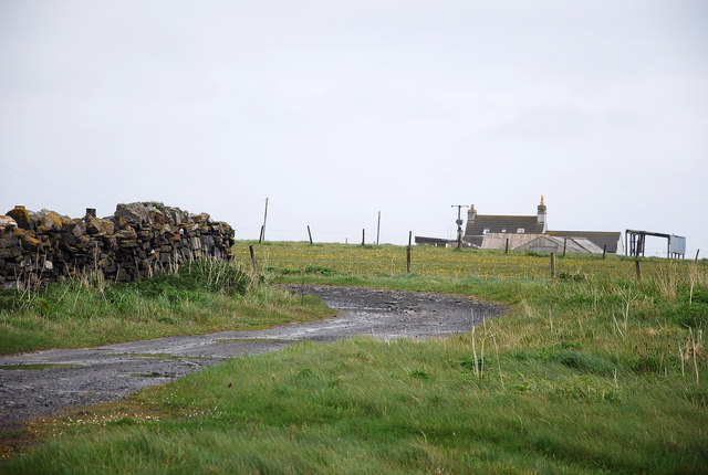
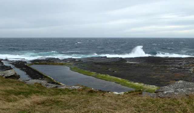
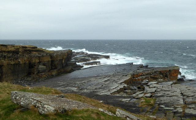
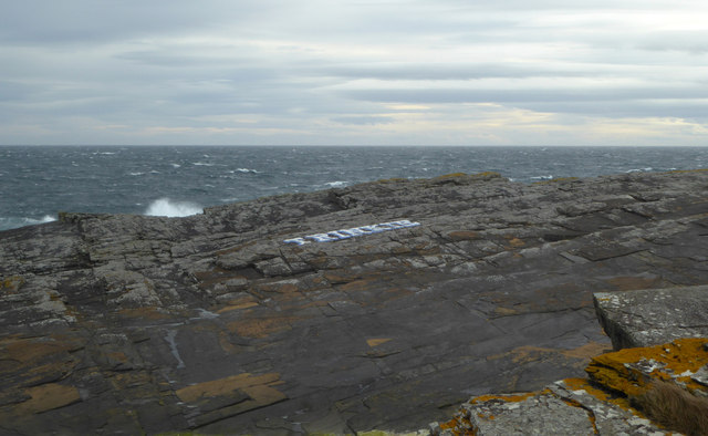
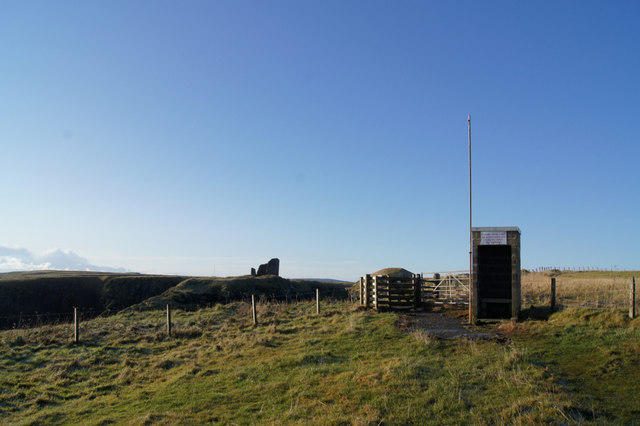
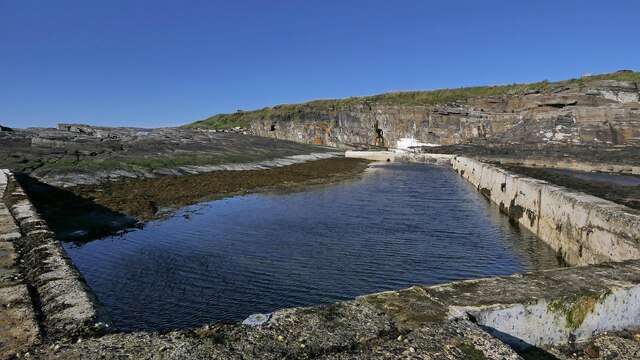
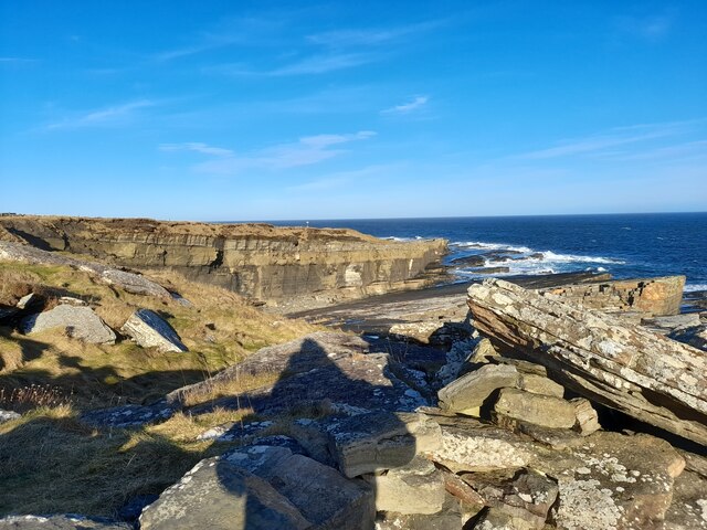
The Kists is a prominent coastal feature located in Caithness, a county in the northernmost part of mainland Scotland. Situated on the east coast, The Kists is a headland that juts out into the North Sea, forming a distinct point along the coastline.

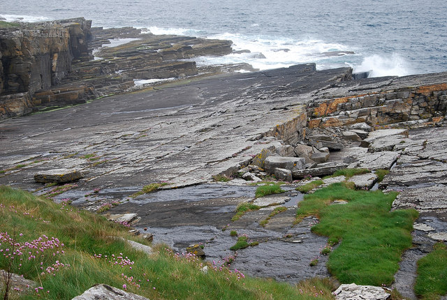
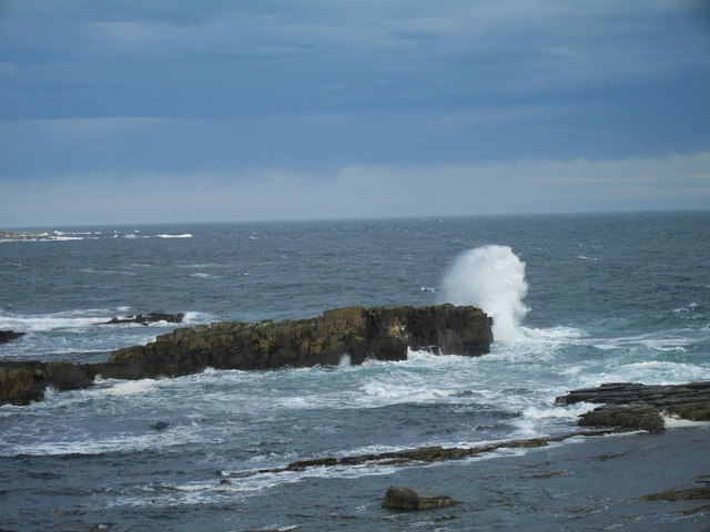
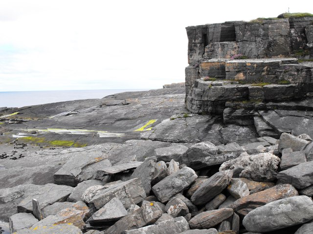
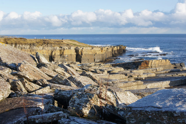
The Kists is characterized by its rugged and dramatic landscape, featuring steep cliffs that provide stunning panoramic views of the surrounding area. These cliffs, composed of sedimentary rock formations, exhibit a variety of colors and textures, adding to the visual appeal of The Kists.

The headland is known for its rich biodiversity, with numerous species of seabirds nesting along its cliffs. Visitors to The Kists often have the opportunity to observe these birds in their natural habitat, creating a unique wildlife experience. Additionally, the surrounding waters are home to a diverse range of marine life, including seals and dolphins, which can sometimes be spotted from the headland.

The Kists is a popular destination for outdoor enthusiasts and nature lovers alike. Hiking trails along the headland offer visitors the chance to explore the area, taking in the breathtaking coastal scenery and enjoying the fresh sea air. The site is also frequented by photographers, who are drawn to the dramatic cliffs and ever-changing light conditions, providing ample opportunities for capturing stunning images.

Overall, The Kists in Caithness is a captivating coastal feature, offering a combination of natural beauty, wildlife, and outdoor recreational opportunities.

If you have any feedback on the listing, please let us know in the comments section below.

The Kists Images

Images are sourced within 2km of 58.441984/-3.0741911 or Grid Reference ND3750. Thanks to Geograph Open Source API. All images are credited.

Farm Track Track to Harden the closest farm to the rifle range.
Farm Track
Track to Harden the closest farm to the rifle range.
Coastal Scene Fractured and shattered pavements of slanting rock make this piece of coastline most attractive.
Coastal Scene
Fractured and shattered pavements of slanting rock make this piece of coastline most attractive.
Wild weather
Wild weather
Cliff Face Cliff face at South Head, below the old Coastguard Station
Cliff Face
Cliff face at South Head, below the old Coastguard Station
Wick Business Park Town planners should pay heed to what out of town developments have done to Wick town centre. This retail park and the Tescos on the north side of town have all but killed a once prosperous town centre.
Wick Business Park
Town planners should pay heed to what out of town developments have done to Wick town centre. This retail park and the Tescos on the north side of town have all but killed a once prosperous town centre.
Welcome to Wick The A99 enters Wick with the cemetery on the right and the new Wick Retail Park on the left.
Welcome to Wick
The A99 enters Wick with the cemetery on the right and the new Wick Retail Park on the left.
The Trinkie Outdoor Swimming Pool Perched at the edge of rocks, the pool naturally collects water from the sea and was created from part of a quarry.
The Trinkie Outdoor Swimming Pool
Perched at the edge of rocks, the pool naturally collects water from the sea and was created from part of a quarry.
Coast at Old Wick Layering of the rocks is clearly visible, along with the remaining tilted and flat slabs. The coastline takes a pounding from the sea.
Coast at Old Wick
Layering of the rocks is clearly visible, along with the remaining tilted and flat slabs. The coastline takes a pounding from the sea.
Trinkie Sign A sign painted on the rocks above the Trinkie outdoor swimming pool. The pool is to the left of shot.
Trinkie Sign
A sign painted on the rocks above the Trinkie outdoor swimming pool. The pool is to the left of shot.
Retail Park in Wick
Retail Park in Wick
Foreshore rock at Trinkie on South Head
Lidl Supermarket, Wick On South Road (A99).
Lidl Supermarket, Wick
On South Road (A99).
Shops, Wick Retail Park
Shore at Old Wick
Shore at Old Wick
Gate into rifle range The ruin of the Castle of Old Wick (visible in the background) stands within a rifle range which dates from World War 1, which I believe is now disused. However - a sentry post stands at this gate in the clifftop path. A red flag would be flown at the flagpole if the range was active.
Gate into rifle range
The ruin of the Castle of Old Wick (visible in the background) stands within a rifle range which dates from World War 1, which I believe is now disused. However - a sentry post stands at this gate in the clifftop path. A red flag would be flown at the flagpole if the range was active.
Trinkie sign, Old Wick, Caithness The sign is painted on rocks next to the Trinkie tidal swimming pool.  A local painter and signwriter volunteers to maintain it.  It was repainted a couple of months before this photo was taken.
Trinkie sign, Old Wick, Caithness
The sign is painted on rocks next to the Trinkie tidal swimming pool. A local painter and signwriter volunteers to maintain it. It was repainted a couple of months before this photo was taken.
Trinkie swimming pool, Old Wick, Caithness The pool was built in a former quarry.  At the time of uploading, the Trinkie Heritage Preservation Group is trying to raise £20,000 to repair storm damage.
Trinkie swimming pool, Old Wick, Caithness
The pool was built in a former quarry. At the time of uploading, the Trinkie Heritage Preservation Group is trying to raise £20,000 to repair storm damage.
Grey Bools and Caithness Flagstone The Grey Bools are cliff-top storm deposits. This picture also shows the sedimentary Caithness flagstone.
Grey Bools and Caithness Flagstone
The Grey Bools are cliff-top storm deposits. This picture also shows the sedimentary Caithness flagstone.
Show me another place!

The Kists is located at Grid Ref: ND3750 (Lat: 58.441984, Lng: -3.0741911)

Unitary Authority: Highland

Police Authority: Highlands and Islands

What 3 Words

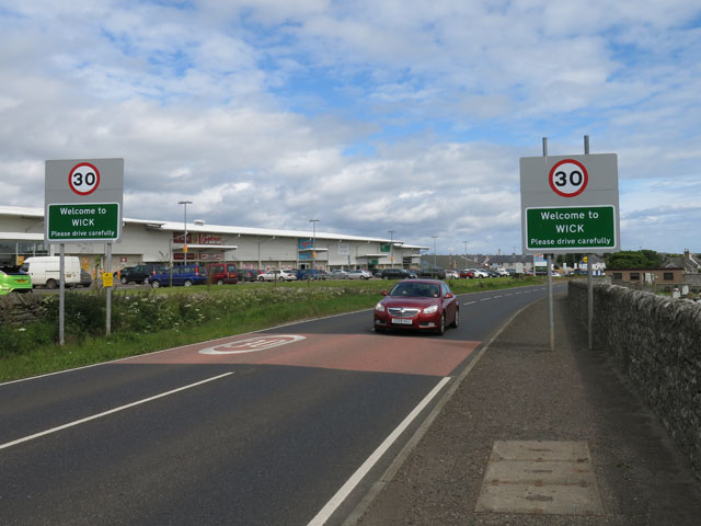
///casino.bitters.dabbling. Near Wick, Highland

Related Wikis

Pulteneytown Parish Church

Pulteneytown Parish Church is located in Argyle Square, Pulteneytown, Wick, Caithness, Scotland. It is a congregation in the Church of Scotland. The church...

Papigoe

Papigoe is a village on the east coast of Caithness, at the head of Broad Haven Bay in the Scottish Highlands and is in the Scottish council area of Highland...

St Joachim's Church, Wick

St Joachim's Church is a Category B listed Roman Catholic church in Wick, Scotland. == History == There was no significant Catholic congregation in Wick...

Pulteneytown Central Church

Pulteneytown Central Church was founded in 1806 in the Pulteneytown area of Wick in Caithness in the far north of Scotland. As years went by, it was renamed...

Nearby Amenities

Located within 500m of 58.441984,-3.0741911
Wick South
Man Made: lighthouse
Seamark Fog Signal Category: bell
Seamark Fog Signal Group: 2
Seamark Fog Signal Period: 10
Seamark Light 1 Character: Fl
Seamark Light 1 Colour: green
Seamark Light 1 Height: 12
Seamark Light 1 Period: 3
Seamark Light 1 Sector End: 270
Seamark Light 1 Sector Start: 253
Seamark Light 2 Character: Fl
Seamark Light 2 Colour: white
Seamark Light 2 Height: 12
Seamark Light 2 Period: 3
Seamark Light 2 Sector End: 286
Seamark Light 2 Sector Start: 270
Seamark Light 3 Character: Fl
Seamark Light 3 Colour: red
Seamark Light 3 Height: 12
Seamark Light 3 Period: 3
Seamark Light 3 Sector End: 329
Seamark Light 3 Sector Start: 286
Seamark Light Reference: A 3528
Seamark Type: light_major
Source: US NGA Pub. 114. 2011-05-26.
Lat/Long: 58.4390491/-3.0788798
Bus Stop
Scalesburn Road
Bus: yes
Naptan AtcoCode: 6700600206
Naptan Bearing: E
Naptan CommonName: Scalesburn Road
Naptan Indicator: opp
Naptan Landmark: Scalesburn Road
Naptan NaptanCode: 45326357
Naptan Street: Willowbank
Naptan Verified: no
Public Transport: platform
Source: naptan_import
Lat/Long: 58.4444477/-3.0806952
Bus Stop
Hillhead Road
Bus: yes
Naptan AtcoCode: 6700600207
Naptan Bearing: W
Naptan CommonName: Hillhead Road
Naptan Indicator: opp
Naptan Landmark: Hillhead Road
Naptan NaptanCode: 45326358
Naptan Street: Willowbank
Naptan Verified: no
Public Transport: platform
Source: naptan_import
Lat/Long: 58.4442721/-3.0802101
Bus Stop
Hillhead Primary School
Bus: yes
Naptan AtcoCode: 6700600208
Naptan Bearing: W
Naptan CommonName: Hillhead Primary School
Naptan Indicator: opp
Naptan Landmark: Hillhead Primary School
Naptan NaptanCode: 45326362
Naptan Street: Willowbank
Naptan Verified: no
Public Transport: platform
Source: naptan_import
Lat/Long: 58.4444136/-3.0762056
Bus Stop
Hillhead Primary School
Bus: yes
Naptan AtcoCode: 6700713265
Naptan Bearing: E
Naptan CommonName: Hillhead Primary School
Naptan Indicator: o/s
Naptan Landmark: Hillhead Primary School
Naptan NaptanCode: 45326359
Naptan Street: Willowbank
Naptan Verified: no
Public Transport: platform
Source: naptan_import
Lat/Long: 58.4445368/-3.0766085
Turning Circle
Lat/Long: 58.4440166/-3.0763812
Turning Circle
Lat/Long: 58.44378/-3.0749236
Turning Circle
Lat/Long: 58.4434551/-3.0795937
Turning Circle
Lat/Long: 58.4436473/-3.0800194
Turning Circle
Lat/Long: 58.4435017/-3.0728452
Give Way
Direction: backward
Lat/Long: 58.4435694/-3.0696322
Generator Method: photovoltaic
Generator Output Electricity: yes
Generator Source: solar
Generator Type: solar_photovoltaic_panel
Location: roof
Power: generator
Lat/Long: 58.4438062/-3.0796722
Generator Method: photovoltaic
Generator Output Electricity: yes
Generator Source: solar
Generator Type: solar_photovoltaic_panel
Location: roof
Power: generator
Lat/Long: 58.4437437/-3.0796735
Generator Method: photovoltaic
Generator Output Electricity: yes
Generator Source: solar
Generator Type: solar_photovoltaic_panel
Location: roof
Power: generator
Lat/Long: 58.4443487/-3.0770516
Generator Method: photovoltaic
Generator Output Electricity: yes
Generator Source: solar
Generator Type: solar_photovoltaic_panel
Location: roof
Power: generator
Lat/Long: 58.4435135/-3.0802166
Generator Method: photovoltaic
Generator Output Electricity: yes
Generator Source: solar
Generator Type: solar_photovoltaic_panel
Location: roof
Power: generator
Lat/Long: 58.4432426/-3.0800504
Generator Method: photovoltaic
Generator Output Electricity: yes
Generator Source: solar
Generator Type: solar_photovoltaic_panel
Location: roof
Power: generator
Lat/Long: 58.4432889/-3.0797553
Generator Method: photovoltaic
Generator Output Electricity: yes
Generator Source: solar
Generator Type: solar_photovoltaic_panel
Location: roof
Power: generator
Lat/Long: 58.4430096/-3.0798975
Generator Method: photovoltaic
Generator Output Electricity: yes
Generator Source: solar
Generator Type: solar_photovoltaic_panel
Location: roof
Power: generator
Lat/Long: 58.4430152/-3.0796212
Generator Method: photovoltaic
Generator Output Electricity: yes
Generator Source: solar
Generator Type: solar_photovoltaic_panel
Location: roof
Power: generator
Lat/Long: 58.4430924/-3.0750668
Generator Method: photovoltaic
Generator Output Electricity: yes
Generator Source: solar
Generator Type: solar_photovoltaic_panel
Location: roof
Power: generator
Lat/Long: 58.4429619/-3.0766949
Generator Method: photovoltaic
Generator Output Electricity: yes
Generator Source: solar
Generator Type: solar_photovoltaic_panel
Location: roof
Power: generator
Lat/Long: 58.4427934/-3.0759519
Generator Method: photovoltaic
Generator Output Electricity: yes
Generator Source: solar
Generator Type: solar_photovoltaic_panel
Location: roof
Power: generator
Lat/Long: 58.4427078/-3.0754517
Generator Method: photovoltaic
Generator Output Electricity: yes
Generator Source: solar
Generator Type: solar_photovoltaic_panel
Location: roof
Power: generator
Lat/Long: 58.4427015/-3.0755925
Generator Method: photovoltaic
Generator Output Electricity: yes
Generator Source: solar
Generator Type: solar_photovoltaic_panel
Location: roof
Power: generator
Lat/Long: 58.4442715/-3.0751071
Generator Method: photovoltaic
Generator Output Electricity: yes
Generator Source: solar
Generator Type: solar_photovoltaic_panel
Location: roof
Power: generator
Lat/Long: 58.4449993/-3.0750172
Generator Method: photovoltaic
Generator Output Electricity: yes
Generator Source: solar
Generator Type: solar_photovoltaic_panel
Location: roof
Power: generator
Lat/Long: 58.4450414/-3.0745626
Generator Method: photovoltaic
Generator Output Electricity: yes
Generator Source: solar
Generator Type: solar_photovoltaic_panel
Location: roof
Power: generator
Lat/Long: 58.4450169/-3.0740234
Generator Method: photovoltaic
Generator Output Electricity: yes
Generator Source: solar
Generator Type: solar_photovoltaic_panel
Location: roof
Power: generator
Lat/Long: 58.4450435/-3.0737056
Generator Method: photovoltaic
Generator Output Electricity: yes
Generator Source: solar
Generator Type: solar_photovoltaic_panel
Location: roof
Power: generator
Lat/Long: 58.4450477/-3.0735822
Generator Method: photovoltaic
Generator Output Electricity: yes
Generator Source: solar
Generator Type: solar_photovoltaic_panel
Location: roof
Power: generator
Lat/Long: 58.4450611/-3.0732201
Generator Method: photovoltaic
Generator Output Electricity: yes
Generator Source: solar
Generator Type: solar_photovoltaic_panel
Location: roof
Power: generator
Lat/Long: 58.4450639/-3.0731034
Generator Method: photovoltaic
Generator Output Electricity: yes
Generator Source: solar
Generator Type: solar_photovoltaic_panel
Location: roof
Power: generator
Lat/Long: 58.4453706/-3.0731396
Generator Method: photovoltaic
Generator Output Electricity: yes
Generator Source: solar
Generator Type: solar_photovoltaic_panel
Location: roof
Power: generator
Lat/Long: 58.4453685/-3.0732429
Generator Method: photovoltaic
Generator Output Electricity: yes
Generator Source: solar
Generator Type: solar_photovoltaic_panel
Location: roof
Power: generator
Lat/Long: 58.4453523/-3.0736318
Generator Method: photovoltaic
Generator Output Electricity: yes
Generator Source: solar
Generator Type: solar_photovoltaic_panel
Location: roof
Power: generator
Lat/Long: 58.4453516/-3.0737337
Generator Method: photovoltaic
Generator Output Electricity: yes
Generator Source: solar
Generator Type: solar_photovoltaic_panel
Location: roof
Power: generator
Lat/Long: 58.4453523/-3.074749
Generator Method: photovoltaic
Generator Output Electricity: yes
Generator Source: solar
Generator Type: solar_photovoltaic_panel
Location: roof
Power: generator
Lat/Long: 58.445325/-3.0750936
Generator Method: photovoltaic
Generator Output Electricity: yes
Generator Source: solar
Generator Type: solar_photovoltaic_panel
Location: roof
Power: generator
Lat/Long: 58.4453622/-3.0742621
Generator Method: photovoltaic
Generator Output Electricity: yes
Generator Source: solar
Generator Type: solar_photovoltaic_panel
Location: roof
Power: generator
Lat/Long: 58.4454211/-3.0742621
Generator Method: photovoltaic
Generator Output Electricity: yes
Generator Source: solar
Generator Type: solar_photovoltaic_panel
Location: roof
Power: generator
Lat/Long: 58.4456527/-3.0743185
Generator Method: photovoltaic
Generator Output Electricity: yes
Generator Source: solar
Generator Type: solar_photovoltaic_panel
Location: roof
Power: generator
Lat/Long: 58.4457131/-3.0743292
Generator Method: photovoltaic
Generator Output Electricity: yes
Generator Source: solar
Generator Type: solar_photovoltaic_panel
Location: roof
Power: generator
Lat/Long: 58.4456527/-3.0737177
Generator Method: photovoltaic
Generator Output Electricity: yes
Generator Source: solar
Generator Type: solar_photovoltaic_panel
Location: roof
Power: generator
Lat/Long: 58.4457369/-3.0737177
Generator Method: photovoltaic
Generator Output Electricity: yes
Generator Source: solar
Generator Type: solar_photovoltaic_panel
Location: roof
Power: generator
Lat/Long: 58.445932/-3.0736855
Generator Method: photovoltaic
Generator Output Electricity: yes
Generator Source: solar
Generator Type: solar_photovoltaic_panel
Location: roof
Power: generator
Lat/Long: 58.4459236/-3.0738089
Generator Method: photovoltaic
Generator Output Electricity: yes
Generator Source: solar
Generator Type: solar_photovoltaic_panel
Location: roof
Power: generator
Lat/Long: 58.4440273/-3.0792967
Willowbank
Place: suburb
Lat/Long: 58.4444465/-3.0800668
Give Way
Direction: forward
Lat/Long: 58.4431589/-3.0809648
Give Way
Direction: backward
Lat/Long: 58.4432153/-3.0788082
Give Way
Direction: backward
Lat/Long: 58.443918/-3.0788986
Give Way
Direction: backward
Lat/Long: 58.4436566/-3.0788098
Give Way
Direction: backward
Lat/Long: 58.4434749/-3.0789017
Give Way
Direction: forward
Lat/Long: 58.4443749/-3.0788298
Give Way
Direction: backward
Lat/Long: 58.444554/-3.0738799
Give Way
Direction: backward
Lat/Long: 58.4446669/-3.0722951
Give Way
Direction: backward
Lat/Long: 58.4429899/-3.0740329
Give Way
Direction: backward
Lat/Long: 58.4432583/-3.0760468
Give Way
Direction: forward
Lat/Long: 58.4432961/-3.0710592
Give Way
Direction: backward
Lat/Long: 58.4436065/-3.0761675
Give Way
Direction: forward
Lat/Long: 58.4436817/-3.0738281
Turning Circle
Lat/Long: 58.4431631/-3.0683293
Turning Circle
Lat/Long: 58.4430307/-3.0661624
Turning Circle
Lat/Long: 58.4444481/-3.0671313
The data included in this document is from www.openstreetmap.org. The data is made available under ODbL.

Have you been to The Kists?

Leave your review of The Kists below (or comments, questions and feedback).