Kirk Geo

Coastal Feature, Headland, Point in Orkney

Scotland

Kirk Geo

Animal trap and sea defences, Warebeth, Orkney The trap is one of nearly 6,000 deployed by the Orkney Native Wildlife Project across Orkney Mainland and the linked southern isles. The objective of the project is to eradicate the non-native stoat, which was first reported on the islands in 2010, in order to protect ground-nesting birds and the Orkney vole.

The sea defences protect Warebeth (also known as Warbeth) cemetery and the possibly medieval  remains of a chapel within it.
Animal trap and sea defences, Warebeth, Orkney Credit: Claire Pegrum

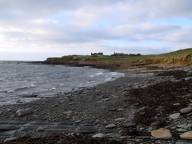
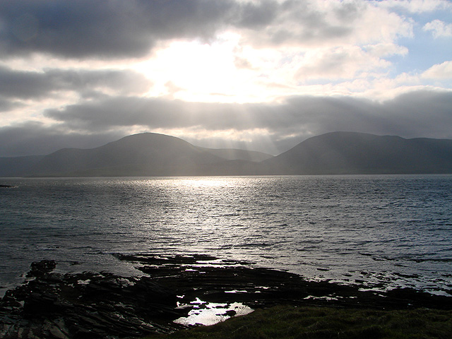
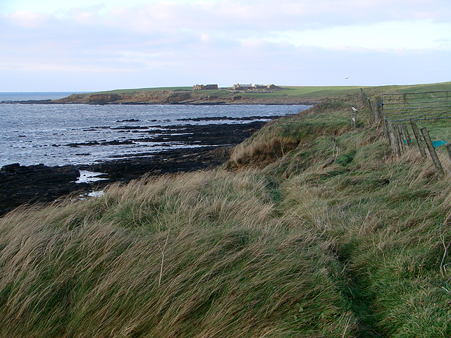
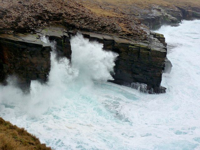
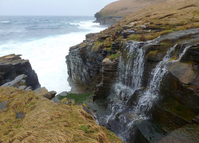
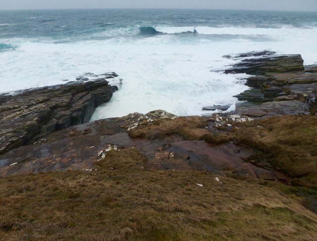
Kirk Geo is a prominent coastal feature located on the Orkney Islands, which are situated off the northeastern coast of Scotland. It is specifically located on the eastern coast of the Mainland, the largest island in the Orkney archipelago. Kirk Geo is a headland that juts out into the North Sea, forming a distinct and picturesque point.

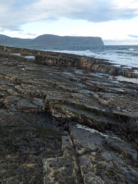
The area surrounding Kirk Geo is characterized by rugged cliffs, which rise dramatically from the sea, offering stunning panoramic views of the surrounding coastline. The headland itself is a relatively flat and grassy area, providing ample space for visitors to explore and enjoy the natural beauty of the location. The grassy slopes are often dotted with wildflowers, adding a burst of color to the landscape.

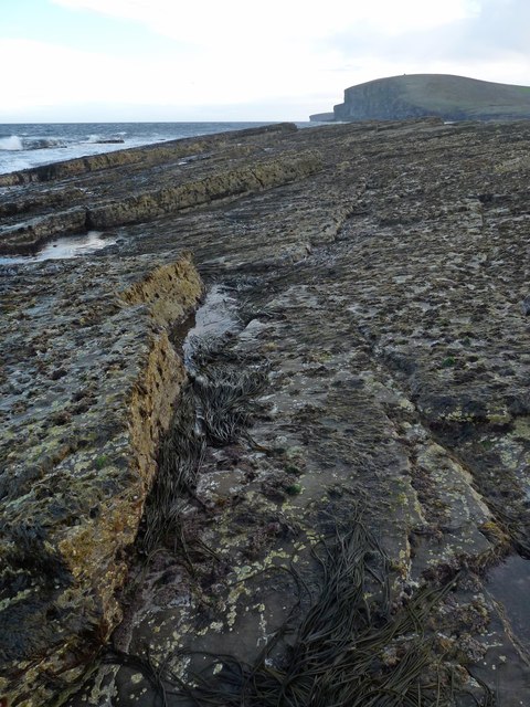
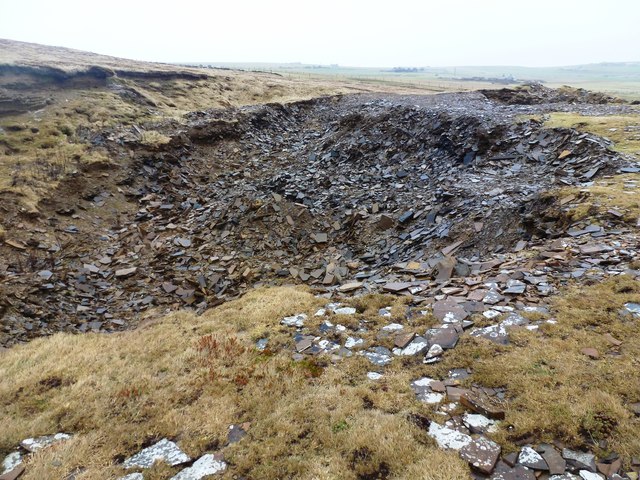
Kirk Geo is also notable for its rich geological history. The cliffs that enclose the headland are composed of sandstone and sedimentary rock, which reveal the geological processes that have shaped the area over millions of years. Fossilized remains of ancient marine life can sometimes be found embedded in the rocks, providing valuable insights into the region's prehistoric past.

Due to its prominent position and scenic surroundings, Kirk Geo is a popular destination for outdoor enthusiasts, hikers, and nature lovers. Visitors can take leisurely walks along the headland, observing the diverse birdlife that inhabits the area, including puffins, guillemots, and kittiwakes. Additionally, the nearby coastal waters offer excellent opportunities for fishing and boating.

In conclusion, Kirk Geo is a striking headland located on the eastern coast of the Orkney Islands. With its rugged cliffs, grassy slopes, and rich geological history, it is a captivating coastal feature that attracts visitors from near and far.

If you have any feedback on the listing, please let us know in the comments section below.
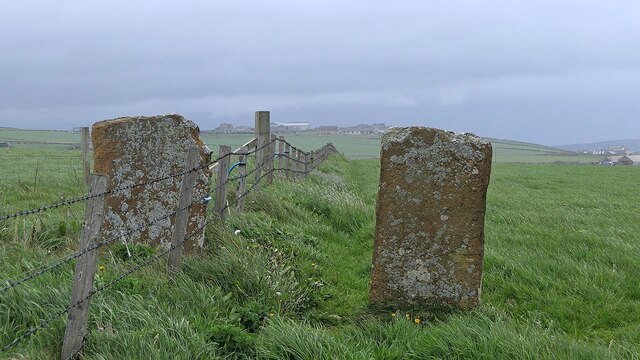
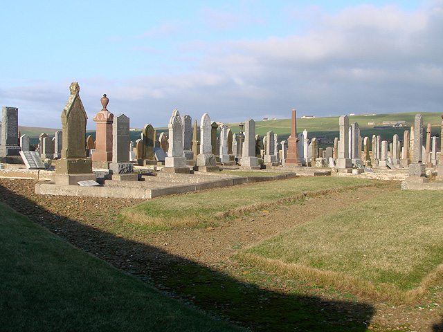
Kirk Geo Images

Images are sourced within 2km of 58.963517/-3.3499853 or Grid Reference HY2209. Thanks to Geograph Open Source API. All images are credited.

Animal trap and sea defences, Warebeth, Orkney The trap is one of nearly 6,000 deployed by the Orkney Native Wildlife Project across Orkney Mainland and the linked southern isles. The objective of the project is to eradicate the non-native stoat, which was first reported on the islands in 2010, in order to protect ground-nesting birds and the Orkney vole.

The sea defences protect Warebeth (also known as Warbeth) cemetery and the possibly medieval  remains of a chapel within it.
Animal trap and sea defences, Warebeth, Orkney
The trap is one of nearly 6,000 deployed by the Orkney Native Wildlife Project across Orkney Mainland and the linked southern isles. The objective of the project is to eradicate the non-native stoat, which was first reported on the islands in 2010, in order to protect ground-nesting birds and the Orkney vole. The sea defences protect Warebeth (also known as Warbeth) cemetery and the possibly medieval remains of a chapel within it.
Standing stones, Warebeth, Orkney From <span class="nowrap"><a title="https://canmore.org.uk/site/1568/leafea" rel="nofollow ugc noopener" href="https://canmore.org.uk/site/1568/leafea">Link</a><img style="margin-left:2px;" alt="External link" title="External link - shift click to open in new window" src="https://s1.geograph.org.uk/img/external.png" width="10" height="10"/></span> : "These are two squared sandstone blocks 4 feet apart, their bases each earthfast in a heap of small stones. The larger is nearly 4 feet high, 2 feet 9 inches wide and 3½ inches thick; the smaller 3 feet 3 inches high, 2 feet 3 inches wide and 3¾ inches thick. The major axis of each is aligned N and S. At their bases are two granite boulders probably not associated with the monument, although the larger boulder now broken, once stood between the blocks with its axis E and W. The stones are perhaps the remnant of some larger construction, but not a circular setting. Allegedly human bones were unearthed by a dog at the bases of the stones."
Standing stones, Warebeth, Orkney
From LinkExternal link : "These are two squared sandstone blocks 4 feet apart, their bases each earthfast in a heap of small stones. The larger is nearly 4 feet high, 2 feet 9 inches wide and 3½ inches thick; the smaller 3 feet 3 inches high, 2 feet 3 inches wide and 3¾ inches thick. The major axis of each is aligned N and S. At their bases are two granite boulders probably not associated with the monument, although the larger boulder now broken, once stood between the blocks with its axis E and W. The stones are perhaps the remnant of some larger construction, but not a circular setting. Allegedly human bones were unearthed by a dog at the bases of the stones."
Noust of Nethertown, Orkney Looking along Hoy Sound between Orkney Mainland and Graemsay.
Noust of Nethertown, Orkney
Looking along Hoy Sound between Orkney Mainland and Graemsay.
No dogs - A path into Stromness cemetery This takes me back to when I was a young sprog working with a respected mentor and colleague, Dave Hunter. Dave was from Sutherland and one day he informed me that "there are no dogs in Sutherland". "Why's that Dave?" I naively asked. "No trees!" came the laconic reply.
No dogs - A path into Stromness cemetery
This takes me back to when I was a young sprog working with a respected mentor and colleague, Dave Hunter. Dave was from Sutherland and one day he informed me that "there are no dogs in Sutherland". "Why's that Dave?" I naively asked. "No trees!" came the laconic reply.
Looking towards Hoy from Warebeth
Warbeth (Stromness) Cemetery Link suggested by Stanley Howe: <span class="nowrap"><a title="http://www.scottish-places.info/features/featurefirst11441.html" rel="nofollow ugc noopener" href="http://www.scottish-places.info/features/featurefirst11441.html">Link</a><img style="margin-left:2px;" alt="External link" title="External link - shift click to open in new window" src="https://s1.geograph.org.uk/img/external.png" width="10" height="10"/></span>
Warbeth (Stromness) Cemetery
Link suggested by Stanley Howe: LinkExternal link
A view towards the ruin of Breckness House Some serious fencing work has been carried out here recently. Barbed and mesh fencing has been constructed along the edge of the beach and it appears to be no longer possible to access the ruin, all walkers being forced onto the beach, which I understand is impassable around the headland at most states of the tide. I don't know how this sits with the Scottish open access laws but it seems a great shortcoming of the local council not to come to an arrangement with the landowner in order to provide suitable walking around the coast, rather than giving the impression that visitors are definitely NOT WELCOME!
A view towards the ruin of Breckness House
Some serious fencing work has been carried out here recently. Barbed and mesh fencing has been constructed along the edge of the beach and it appears to be no longer possible to access the ruin, all walkers being forced onto the beach, which I understand is impassable around the headland at most states of the tide. I don't know how this sits with the Scottish open access laws but it seems a great shortcoming of the local council not to come to an arrangement with the landowner in order to provide suitable walking around the coast, rather than giving the impression that visitors are definitely NOT WELCOME!
A view towards Hoy from Warebeth
Footpath along Stennigor The ruin at Breck Ness is seen on the horizon.
Footpath along Stennigor
The ruin at Breck Ness is seen on the horizon.
Cemetery west of Stromness Black Craigs in the background.
Cemetery west of Stromness
Black Craigs in the background.
Point of Spoil, Breck Ness, Orkney Looking towards Black Craig.

This rocky tip is the only land which lies within the grid square.
Point of Spoil, Breck Ness, Orkney
Looking towards Black Craig. This rocky tip is the only land which lies within the grid square.
Point of Spoil, Breck Ness, Orkney Looking towards the Kame of Hoy.

This rocky tip is the only land which lies within the grid square.
Point of Spoil, Breck Ness, Orkney
Looking towards the Kame of Hoy. This rocky tip is the only land which lies within the grid square.
Agla Bar - Billia Croo The protective arm of an imposing geo (Johnson's Cave) on an exposed day.
A narrow coastal path passes here but it is daunting on a day like this and not without some danger
Agla Bar - Billia Croo
The protective arm of an imposing geo (Johnson's Cave) on an exposed day. A narrow coastal path passes here but it is daunting on a day like this and not without some danger
Hole o' Row The end of the Burn of Dykeside as it tumbles into the sea.
A small pathway traverses the cliffs here, between Stromness and Yesnaby. A few places can be daunting on wet and windy days.
Hole o' Row
The end of the Burn of Dykeside as it tumbles into the sea. A small pathway traverses the cliffs here, between Stromness and Yesnaby. A few places can be daunting on wet and windy days.
Filled Quarry - Johnson's Hole Only on very old maps is this quarry marked.
Shales and mudstones seem to have been taken from here, possibly for roofing.
Most of what is seen is fairly recent backfill
Filled Quarry - Johnson's Hole
Only on very old maps is this quarry marked. Shales and mudstones seem to have been taken from here, possibly for roofing. Most of what is seen is fairly recent backfill
Whale Geo - Billia Croo A messy day at the seaside.
The footpath between Stromness and Yesnaby runs past here. On a wet and windy day it can be dangerous.
Whale Geo - Billia Croo
A messy day at the seaside. The footpath between Stromness and Yesnaby runs past here. On a wet and windy day it can be dangerous.
Sedimentary pavement at Billia Croo
Farm Buildings Near Feolquoy We used the private road up passed these large farm building on the way to bag the Hill of Lynedardy. The cattle seen on route looked very fit and well.
Farm Buildings Near Feolquoy
We used the private road up passed these large farm building on the way to bag the Hill of Lynedardy. The cattle seen on route looked very fit and well.
Show me another place!

Kirk Geo is located at Grid Ref: HY2209 (Lat: 58.963517, Lng: -3.3499853)

Unitary Authority: Orkney Islands

Police Authority: Highlands and Islands

What 3 Words

///inflation.tarred.boot. Near Stromness, Orkney Islands

Related Wikis

Breckness House

Breckness House, sometimes known as Breckness Castle, is the site of the 17th century mansion, chapel and burial ground, built by George Graham (1565–1643...

Oyster wave energy converter

The Oyster was a hydro-electric wave energy device that used the motion of ocean waves to generate electricity. It was made up of a Power Connector Frame...

Hoy Sound

Hoy Sound is a body of salt water subject to tidal currents situated south of the town of Stromness in the Orkney archipelago of Scotland. The sound lies...

Stromness Museum

Stromness Museum is a small independent museum in the town of Stromness in Orkney, Scotland focusing on the town's connections to maritime and natural...

Nearby Amenities

Located within 500m of 58.963517,-3.3499853
Breckness - site of chapel + burial ground
Historic: archaeological_site
Lat/Long: 58.9639081/-3.3500542
Site of Iron Age broch
Historic: archaeological_site
Lat/Long: 58.9637081/-3.3495464
Breckness
Place: locality
Lat/Long: 58.9645834/-3.3524351
The data included in this document is from www.openstreetmap.org. The data is made available under ODbL.

Have you been to Kirk Geo?

Leave your review of Kirk Geo below (or comments, questions and feedback).