Beacon Point

Coastal Feature, Headland, Point in Devon South Hams

England

Beacon Point

Bluebells, Wrinkle Wood Together with the neighbouring Furzedown Wood, a fine display of Hyacinthoides non-scripta.
Bluebells, Wrinkle Wood Credit: Derek Harper

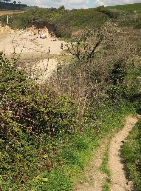
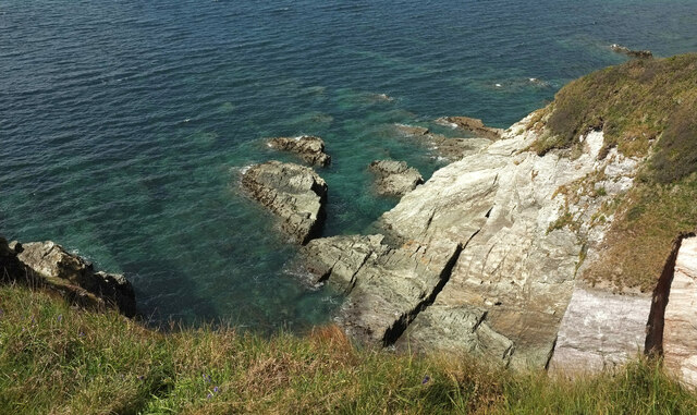
Beacon Point is a prominent coastal feature located in the county of Devon, England. Situated on the southern coast, it is known for its stunning views and unique geological formations. As a headland jutting out into the sea, Beacon Point offers a commanding vantage point overlooking the surrounding area.

The point derives its name from the historic use of beacons that were once lit on this headland to serve as navigational aids for passing ships. These beacons were crucial in guiding seafarers safely along the treacherous coastline. Although the beacons themselves are no longer in use, their legacy is still evident in the name of the point.

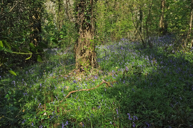
Geologically, Beacon Point is characterized by its rugged cliffs and distinctive rock formations. The cliffs, comprised mainly of sedimentary rock layers, showcase a variety of colors and textures, providing a visual spectacle for visitors. These cliffs also serve as a habitat for various seabird species, including gulls and cormorants, which can often be seen nesting on the ledges.

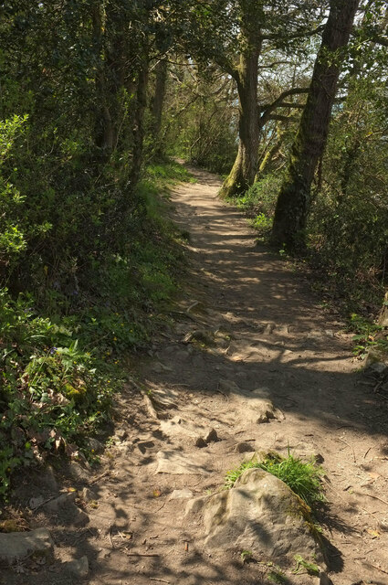
From Beacon Point, visitors can enjoy breathtaking panoramic views of the English Channel and the surrounding coastline. On a clear day, it is possible to see as far as the neighboring county of Cornwall. The point also offers access to a picturesque coastal path, allowing visitors to explore the area further and discover hidden coves and secluded beaches.

Due to its natural beauty and historical significance, Beacon Point has become a popular destination for nature enthusiasts, hikers, and history buffs alike. Its combination of stunning scenery, geological wonders, and cultural heritage make it a must-visit location for anyone exploring the Devon coastline.

If you have any feedback on the listing, please let us know in the comments section below.

Beacon Point Images

Images are sourced within 2km of 50.29611/-3.943421 or Grid Reference SX6145. Thanks to Geograph Open Source API. All images are credited.

Bluebells, Wrinkle Wood Together with the neighbouring Furzedown Wood, a fine display of Hyacinthoides non-scripta.
Bluebells, Wrinkle Wood
Together with the neighbouring Furzedown Wood, a fine display of Hyacinthoides non-scripta.
Bluebells, Wrinkle Wood Looking right from <a href="https://www.geograph.org.uk/photo/6996392">SX6247 : Bluebells, Wrinkle Wood</a>.
Bluebells, Wrinkle Wood
Looking right from SX6247 : Bluebells, Wrinkle Wood.
Bluebells, Wrinkle Wood Looking across the sloping hillside.
Bluebells, Wrinkle Wood
Looking across the sloping hillside.
Footpath, Wrinkle Wood Kingston footpath 3 takes a diagonal route down the bluebell-swathed hillside.
Footpath, Wrinkle Wood
Kingston footpath 3 takes a diagonal route down the bluebell-swathed hillside.
By the Erme estuary This popular spot is mapped as the eastern end of the ford used by the coast path - see <a href="https://www.geograph.org.uk/photo/2731430">SX6147 : Erme estuary</a>. I was hastening to catch the rest of my party, after being thoroughly distracted by the bluebells in Wrinkle Wood; had I looked more closely I would have seen that they were here. Instead I rushed on for a mile or two before concluding that I must have overtaken them.
By the Erme estuary
This popular spot is mapped as the eastern end of the ford used by the coast path - see SX6147 : Erme estuary. I was hastening to catch the rest of my party, after being thoroughly distracted by the bluebells in Wrinkle Wood; had I looked more closely I would have seen that they were here. Instead I rushed on for a mile or two before concluding that I must have overtaken them.
Coast path in Wrinkle Wood Kingston footpath 7 above the Erme estuary.
Coast path in Wrinkle Wood
Kingston footpath 7 above the Erme estuary.
Coast path above the Erme estuary Following Kingston footpath 7.
Coast path above the Erme estuary
Following Kingston footpath 7.
Erme estuary From the coast path as shown in <a href="https://www.geograph.org.uk/photo/6996598">SX6147 : Coast path above the Erme estuary</a>. The estuary is 350 metres across at this point, with the former coastguard cottages on the far side, but the main channel runs on this side, where it is followed by the parish boundary between Kingston (this side) and Holbeton.
Erme estuary
From the coast path as shown in SX6147 : Coast path above the Erme estuary. The estuary is 350 metres across at this point, with the former coastguard cottages on the far side, but the main channel runs on this side, where it is followed by the parish boundary between Kingston (this side) and Holbeton.
Coast path above the Erme estuary Kingston footpath 7 seen a little south of <a href="https://www.geograph.org.uk/photo/6996598">SX6147 : Coast path above the Erme estuary</a>.
Coast path above the Erme estuary
Kingston footpath 7 seen a little south of SX6147 : Coast path above the Erme estuary.
Trees behind Wonwell Beach In the foreground is a fragment of the coast path, Kingston footpath 7.
Trees behind Wonwell Beach
In the foreground is a fragment of the coast path, Kingston footpath 7.
Wonwell Beach The coast path, following Kingston footpath 7, drops to cross the beach south of Malthouse Point.
Wonwell Beach
The coast path, following Kingston footpath 7, drops to cross the beach south of Malthouse Point.
Star of Bethlehem, Wonwell Beach Ornithogalum umbellatum, seen where <a href="https://www.geograph.org.uk/photo/6996710">SX6147 : Wonwell Beach</a> was taken.
Star of Bethlehem, Wonwell Beach
Ornithogalum umbellatum, seen where SX6147 : Wonwell Beach was taken.
Approaching Wonwell Beach The coast path, following Kingston footpath 7, is dropping to cross the beach south of Malthouse Point.
Approaching Wonwell Beach
The coast path, following Kingston footpath 7, is dropping to cross the beach south of Malthouse Point.
Headland at Wonwell Beach Cliffs at the southwestern end of the cove adjoining the beach, with Owen's Hill and Point across the Erme estuary.
Headland at Wonwell Beach
Cliffs at the southwestern end of the cove adjoining the beach, with Owen's Hill and Point across the Erme estuary.
Muxham Point The clifftop on the south side of the headland, with Owen's Hill and Point across the Erme estuary. A brighter moment than shown at <a href="https://www.geograph.org.uk/photo/6288574">SX6146 : Coast path at Muxham Point</a>.
Muxham Point
The clifftop on the south side of the headland, with Owen's Hill and Point across the Erme estuary. A brighter moment than shown at SX6146 : Coast path at Muxham Point.
Fernycombe Point Also shown at <a title="https://www.geograph.org.uk/gridref/SX6146?centi=SX615464&nl=1" href="https://www.geograph.org.uk/gridref/SX6146?centi=SX615464&nl=1">Link</a> from a different angle - see also <a href="https://www.geograph.org.uk/photo/6830347">SX6146 : Rocks, Fernycombe Beach</a>.
Fernycombe Point
Also shown at Link from a different angle - see also SX6146 : Rocks, Fernycombe Beach.
Clifftop above Fernycombe Beach Looking right from <a href="https://www.geograph.org.uk/photo/6997000">SX6146 : Fernycombe Point</a>, with a footpath signpost at the junction of the coast path with a permissive path inland to Kingston.
Clifftop above Fernycombe Beach
Looking right from SX6146 : Fernycombe Point, with a footpath signpost at the junction of the coast path with a permissive path inland to Kingston.
Cliffs, Fernycombe Beach <a href="https://www.geograph.org.uk/photo/6830338">SX6146 : Cliff erosion above Fernycombe Beach</a> is a detail of this, taken a few metres away. The beach is also shown at <a href="https://www.geograph.org.uk/photo/6288617">SX6146 : Fernycombe Beach</a>.
Cliffs, Fernycombe Beach
SX6146 : Cliff erosion above Fernycombe Beach is a detail of this, taken a few metres away. The beach is also shown at SX6146 : Fernycombe Beach.
Show me another place!

Beacon Point is located at Grid Ref: SX6145 (Lat: 50.29611, Lng: -3.943421)

Administrative County: Devon

District: South Hams

Police Authority: Devon and Cornwall

What 3 Words

///endings.alpha.following. Near Yealmpton, Devon

Nearby Locations

Beacon Beach Beacon Point

Related Wikis

River Erme

The Erme is a river in south Devon, England. From its source on Dartmoor it flows in a generally southerly direction past some of the best-preserved archaeological...

SS Persier (1918)

Persier was a 5,382 GRT cargo ship which was built in 1918 as War Buffalo for the British Shipping Controller. In 1919, she was sold to Belgium and renamed...

Kingston, Devon

Kingston is civil parish and small scattered village in the South Hams, Devon, England. It is three miles south west of Modbury and about a mile from the...

Battisborough Cross

Battisborough Cross is a village in the parish of Holbeton near Plymouth on the south coast of Devon, England . It is within the South Devon Area of Outstanding...

Nearby Amenities

Located within 500m of 50.29611,-3.943421
Source: PGS
Lat/Long: 50.2975652/-3.9453374
The Beacon
Place: locality
Source Name: OS OpenData StreetView
Lat/Long: 50.2979275/-3.9427614
Tourism: viewpoint
Lat/Long: 50.2975488/-3.9425071
The data included in this document is from www.openstreetmap.org. The data is made available under ODbL.

Have you been to Beacon Point?

Leave your review of Beacon Point below (or comments, questions and feedback).