Borness Point

Coastal Feature, Headland, Point in Kirkcudbrightshire

Scotland

Borness Point

Brighouse Bay looking SSE
Brighouse Bay looking SSE Credit: Kirsty Smith

Borness Point is a picturesque headland located on the southern coast of Scotland in Kirkcudbrightshire. Situated near the town of Gatehouse of Fleet, this coastal feature attracts visitors with its stunning natural beauty and historical significance.

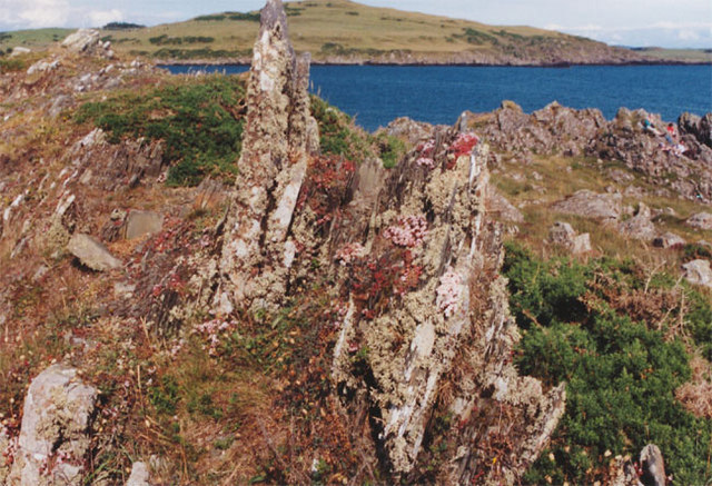
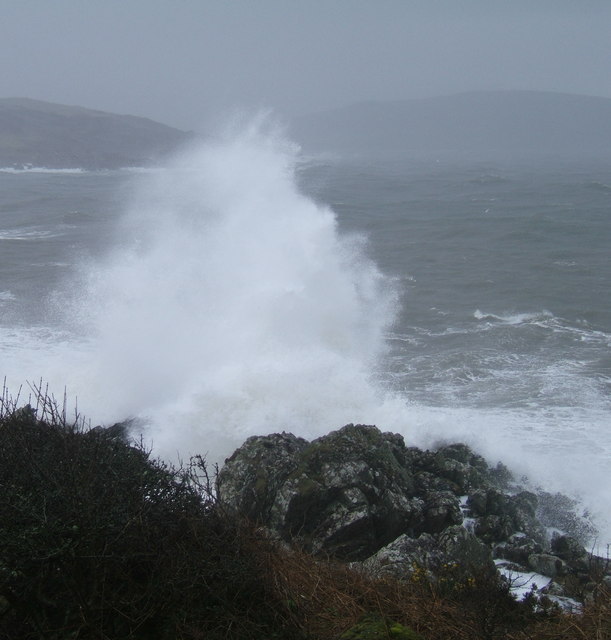
Rising majestically from the Irish Sea, Borness Point offers breathtaking panoramic views of the surrounding landscape. The headland is characterized by rugged cliffs, rocky outcrops, and sandy beaches, providing a diverse range of habitats for a variety of wildlife. It is a popular spot for birdwatching, with numerous seabirds and waders frequenting the area.

The history of Borness Point can be traced back to ancient times, with archaeological remains indicating human occupation as early as the Bronze Age. The headland was also a strategic location during the Roman occupation of Britain, and remnants of a Roman fort can still be seen today.

Visitors to Borness Point can enjoy leisurely walks along the coastal path, taking in the breathtaking scenery and exploring the diverse flora and fauna. The sandy beaches provide an ideal spot for picnics and sunbathing, while the rocky cliffs offer opportunities for rock climbing and wildlife observation.

Throughout the year, Borness Point hosts various events and activities, including guided nature walks, historical tours, and educational programs. The area is well-maintained, with designated parking areas and facilities for visitors.

Overall, Borness Point is a captivating coastal feature that combines natural beauty, historical significance, and recreational opportunities. It is a must-visit destination for nature lovers, history enthusiasts, and anyone seeking a tranquil escape by the sea.

If you have any feedback on the listing, please let us know in the comments section below.

Borness Point Images

Images are sourced within 2km of 54.778167/-4.1528399 or Grid Reference NX6144. Thanks to Geograph Open Source API. All images are credited.

Brighouse Bay looking SSE
House forsaken Eighteenth century folk had the energy and the resources to build fine homes like this even in remote places. With a gaudy caravan park less than a mile away, the real essence of rural life stands as a monument to our collective indifference to the efforts of our ancestors.
House forsaken
Eighteenth century folk had the energy and the resources to build fine homes like this even in remote places. With a gaudy caravan park less than a mile away, the real essence of rural life stands as a monument to our collective indifference to the efforts of our ancestors.
The big hoose at Borness, Galloway The daffodils are more advanced here than where I live much farther south than this.
The big hoose at Borness, Galloway
The daffodils are more advanced here than where I live much farther south than this.
Borness Point, Galloway The beautifully green rolling hills of Galloway give way to a very jagged coastline. It's like a beautiful woman with some rough edges and sharp nails
Borness Point, Galloway
The beautifully green rolling hills of Galloway give way to a very jagged coastline. It's like a beautiful woman with some rough edges and sharp nails
Galloway Coast Taken at Borness. The Galloway coastline can look menacing and runs counter to its undulating emerald greenery just behind.
Galloway Coast
Taken at Borness. The Galloway coastline can look menacing and runs counter to its undulating emerald greenery just behind.
Borness Point, Galloway It's a very exciting coastline
Borness Point, Galloway
It's a very exciting coastline
Brighouse Bay A beautiful south facing sandy bay with clear views to the Isle of Man on most days
Brighouse Bay
A beautiful south facing sandy bay with clear views to the Isle of Man on most days
Lichen-covered rocks, Brighouse bay
Brighouse Bay
Brighouse Bay
Muncraig Hill View View across grazing fields towards Whitehill from the Chapelton Row-Muncraig lane on southern slopes of Muncraig Hill.
Muncraig Hill View
View across grazing fields towards Whitehill from the Chapelton Row-Muncraig lane on southern slopes of Muncraig Hill.
Meteor Landing STREWTH ! - just stopped in time!
Meteor Landing
STREWTH ! - just stopped in time!
Cairn at Borness Bar Also showing the footpath down to Borness Batteries
Cairn at Borness Bar
Also showing the footpath down to Borness Batteries
Cairn at Borness Bar
Harrison's Bay from Borness Point
Brighouse Bay near Dunrod Point
Brighouse Bay at low tide
Borness Point
Borness Point
Rummlekirn Brighouse Bay Caravan Park can be seen in the background
Rummlekirn
Brighouse Bay Caravan Park can be seen in the background
Show me another place!

Borness Point is located at Grid Ref: NX6144 (Lat: 54.778167, Lng: -4.1528399)

Unitary Authority: Dumfries and Galloway

Police Authority: Dumfries and Galloway

What 3 Words

///campsites.vaulting.neutron. Near Kirkcudbright, Dumfries & Galloway

Related Wikis

Borness

Borness is a farm of around 1550 acres on the coast of Borgue Parish in the Stewartry of Kirkcudbrightshire (now part of Dumfries and Galloway). It is...

Kirkandrews, Dumfries and Galloway

Kirkandrews, sometimes written as Kirkanders in older documents, is a coastal hamlet about 9 kilometres (6 mi) west-southwest of Kirkcudbright in Dumfries...

Borgue Old House

Borgue Old House is a ruined Y-plan house, about 300 metres (0.2 mi) east of Borgue in Dumfries and Galloway, Scotland. Built in 1680, but probably incorporating...

Borgue, Dumfries and Galloway

Borgue (pronounced /ˈbɔrɡ/; Scottish Gaelic: Borgh) is a village and parish in the Stewartry of Kirkcudbright in Dumfries and Galloway, Scotland. It lies...

Nearby Amenities

Located within 500m of 54.778167,-4.1528399
Source: PGS
Lat/Long: 54.7778198/-4.1524105
Source: PGS
Lat/Long: 54.7780975/-4.1488253
Source: PGS
Lat/Long: 54.7777675/-4.1479697
Source: PGS
Lat/Long: 54.7775226/-4.1484823
Source: PGS
Lat/Long: 54.7773026/-4.1485844
Source: PGS
Lat/Long: 54.7773353/-4.1472837
Source: PGS
Lat/Long: 54.7775932/-4.1465062
Source: PGS
Lat/Long: 54.7771844/-4.1455626
Source: PGS
Lat/Long: 54.7770633/-4.1453109
Source: Landsat photo
Lat/Long: 54.7802908/-4.1592683
Source: Landsat photo
Lat/Long: 54.7798484/-4.1578445
Source: Landsat photo
Lat/Long: 54.7798781/-4.1572105
Harrison Bay
Natural: bay
Lat/Long: 54.780482/-4.1554724
Bench
Lat/Long: 54.7784072/-4.1499174
The data included in this document is from www.openstreetmap.org. The data is made available under ODbL.

Have you been to Borness Point?

Leave your review of Borness Point below (or comments, questions and feedback).