Brackness Hole

Coastal Feature, Headland, Point in Ayrshire

Scotland

Brackness Hole

Portandea Looking North from Portandea. A strange sheltered but remote part of the coast with an abandoned house on it and a sandy beach on the South side.
Portandea Credit: John White

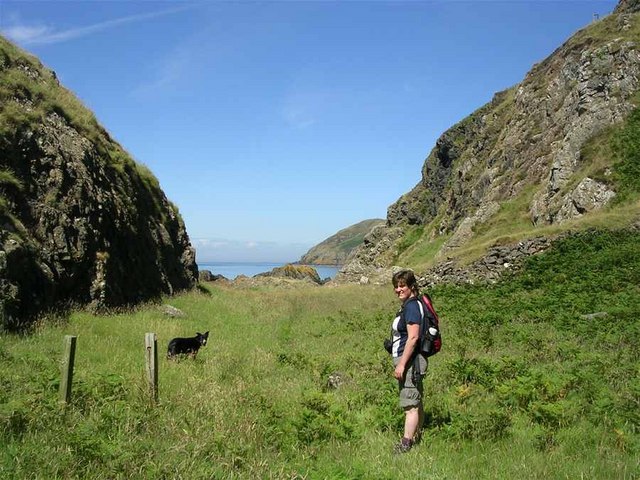
Brackness Hole is a prominent coastal feature located in Ayrshire, Scotland. Situated on the western coast of Scotland, it is a headland that extends into the Firth of Clyde. This point is renowned for its picturesque views and natural beauty.

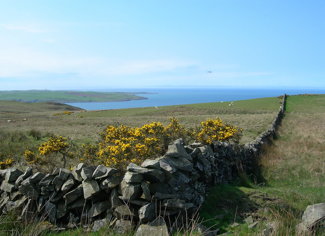
The headland of Brackness Hole is characterized by rugged cliffs that rise dramatically from the sea, reaching heights of up to 100 meters. These cliffs are composed of sedimentary rocks, primarily sandstone and limestone, which have been shaped by the erosive forces of wind and water over millions of years. They showcase fascinating geological formations, including caves, arches, and stacks, adding to the area's allure.

Visitors to Brackness Hole can enjoy panoramic vistas of the Firth of Clyde, with its sparkling blue waters stretching as far as the eye can see. The headland also offers breathtaking views of the surrounding coastline and nearby islands, such as Arran and the Cumbraes.

The coastal cliffs of Brackness Hole provide a habitat for a diverse range of flora and fauna. Seabirds, including gulls, fulmars, and kittiwakes, can be seen nesting on the cliffs, while seals and dolphins often frequent the waters below.

Access to Brackness Hole is possible via a well-maintained coastal path that winds its way along the cliff tops, allowing visitors to explore the area at their own pace. The headland is a popular spot for hikers, nature enthusiasts, and photographers, who are captivated by its natural splendor and tranquility.

In summary, Brackness Hole is a stunning coastal feature in Ayrshire, offering breathtaking views, fascinating geology, and a rich diversity of wildlife. It is a must-visit destination for anyone seeking to experience the beauty of Scotland's western coastline.

If you have any feedback on the listing, please let us know in the comments section below.

Brackness Hole Images

Images are sourced within 2km of 55.047774/-5.0528617 or Grid Reference NX0576. Thanks to Geograph Open Source API. All images are credited.

Portandea Looking North from Portandea. A strange sheltered but remote part of the coast with an abandoned house on it and a sandy beach on the South side.
Portandea
Looking North from Portandea. A strange sheltered but remote part of the coast with an abandoned house on it and a sandy beach on the South side.
North End of Currarie Port
South Side of Currarie Bay
Towards Corsewall Point Looking across the Firth of Clyde at the entrance to Loch Ryan.  Corsewall Point is the second promontory from the left.  Northern Ireland is just visible on the horizon.
Towards Corsewall Point
Looking across the Firth of Clyde at the entrance to Loch Ryan. Corsewall Point is the second promontory from the left. Northern Ireland is just visible on the horizon.
The March Burn The burn tumbles down the steep cliff to reach the Firth of Clyde.  Viewed on a fine late-April morning.
The March Burn
The burn tumbles down the steep cliff to reach the Firth of Clyde. Viewed on a fine late-April morning.
Portandea Looking down into the bay from the top of the cliffs.
Portandea
Looking down into the bay from the top of the cliffs.
Portandea Track Looking down the track to Portandea, with Ailsa Craig in the distance, on a fine late-April morning.
Portandea Track
Looking down the track to Portandea, with Ailsa Craig in the distance, on a fine late-April morning.
Clyde View Looking across the Firth of Clyde towards Ailsa Craig.
Clyde View
Looking across the Firth of Clyde towards Ailsa Craig.
Sheep and Lambs Sheep and lambs on the lower slopes of Penderry Hill.
Sheep and Lambs
Sheep and lambs on the lower slopes of Penderry Hill.
Coastline seen from the Belfast-Stranraer Ferry Coastline, most likely near Brackness Hole, as seen from the Belfast-Stranraer Ferry a few minutes before entering the port of Stranraer. I hope the coordinates and coastal features are assigned correctly, but I like the image.
Coastline seen from the Belfast-Stranraer Ferry
Coastline, most likely near Brackness Hole, as seen from the Belfast-Stranraer Ferry a few minutes before entering the port of Stranraer. I hope the coordinates and coastal features are assigned correctly, but I like the image.
By Shallochwreck Burn Looking down the farm track towards the Firth of Clyde, with the Mull of Kintyre visible on the skyline.
By Shallochwreck Burn
Looking down the farm track towards the Firth of Clyde, with the Mull of Kintyre visible on the skyline.
Rough Grazing With A View Looking across the rough grazing land towards the Firth of Clyde, with the Mull of Kintyre visible on the skyline.
Rough Grazing With A View
Looking across the rough grazing land towards the Firth of Clyde, with the Mull of Kintyre visible on the skyline.
Looking Up The Hill Looking up the western slopes of Green Bennan.
Looking Up The Hill
Looking up the western slopes of Green Bennan.
Hill Country Looking up Shallochwreck Burn and the hill grazing land.
Hill Country
Looking up Shallochwreck Burn and the hill grazing land.
North From Donald Bowie Looking north along the dyke from the edge of the small hill called Donald Bowie.  Bennane Head is shown on the skyline.
North From Donald Bowie
Looking north along the dyke from the edge of the small hill called Donald Bowie. Bennane Head is shown on the skyline.
English Stonecrop The small English Stonecrop (Sedum anglicum) growing on the south-facing slope of Donald Bowie.
English Stonecrop
The small English Stonecrop (Sedum anglicum) growing on the south-facing slope of Donald Bowie.
Common Rock-Rose Common Rock-Rose (Helianthemum nummularium), with its distinctive 5-petalled flower, and its size shown by comparison with the walking pole.  This plant favours grassy and rocky places on lime.
Common Rock-Rose
Common Rock-Rose (Helianthemum nummularium), with its distinctive 5-petalled flower, and its size shown by comparison with the walking pole. This plant favours grassy and rocky places on lime.
The Interconnector Goes Under The Sea Currarie Port, where the Interconnector leaves for Northern Ireland.  The last 3 miles of this recently constructed power line lie underground.  On the surface, it is pleasing to note that there is now very little evidence of the excavation.
The Interconnector Goes Under The Sea
Currarie Port, where the Interconnector leaves for Northern Ireland. The last 3 miles of this recently constructed power line lie underground. On the surface, it is pleasing to note that there is now very little evidence of the excavation.
Show me another place!

Brackness Hole is located at Grid Ref: NX0576 (Lat: 55.047774, Lng: -5.0528617)

Unitary Authority: South Ayrshire

Police Authority: Ayrshire

What 3 Words

///recent.point.completed. Near Cairnryan, Dumfries & Galloway

Related Wikis

Glenapp Castle

Glenapp Castle, formerly the family seat of the Earl of Inchcape, is now a luxury hotel and restaurant located about 1+1⁄2 miles (2.5 kilometres) southeast...

Ballantrae

Ballantrae is a community in Carrick, South Ayrshire, Scotland. The name probably comes from the Scottish Gaelic Baile na Tràgha, meaning the "town by...

River Stinchar

The River Stinchar ( STIN-shər) is a river in South Ayrshire, Scotland. It flows south west from the Galloway Forest Park to enter the Firth of Clyde at...

Ballantrae Windmill

The Ballantrae Windmill, on Mill Hill was a late 17th or early 18th century vaulted tower windmill, the ruins of which are located above the old raised...

Nearby Amenities

Located within 500m of 55.047774,-5.0528617
Created By: dmgroom_coastlines
Source: PGS
Lat/Long: 55.051913/-5.051291
Created By: dmgroom_coastlines
Source: PGS
Lat/Long: 55.050885/-5.051461
Created By: dmgroom_coastlines
Source: PGS
Lat/Long: 55.05087/-5.052353
Created By: dmgroom_coastlines
Source: PGS
Lat/Long: 55.050618/-5.052117
Created By: dmgroom_coastlines
Source: PGS
Lat/Long: 55.050106/-5.052091
Created By: dmgroom_coastlines
Source: PGS
Lat/Long: 55.049843/-5.052524
Created By: dmgroom_coastlines
Source: PGS
Lat/Long: 55.049587/-5.052511
Created By: dmgroom_coastlines
Source: PGS
Lat/Long: 55.049331/-5.052498
Created By: dmgroom_coastlines
Source: PGS
Lat/Long: 55.048299/-5.052891
Created By: dmgroom_coastlines
Source: PGS
Lat/Long: 55.047788/-5.052865
Created By: dmgroom_coastlines
Source: PGS
Lat/Long: 55.047276/-5.052839
Created By: dmgroom_coastlines
Source: PGS
Lat/Long: 55.046252/-5.052786
Created By: dmgroom_coastlines
Source: PGS
Lat/Long: 55.045747/-5.052314
Created By: dmgroom_coastlines
Source: PGS
Lat/Long: 55.045492/-5.052301
Created By: dmgroom_coastlines
Source: PGS
Lat/Long: 55.044464/-5.052471
Created By: dmgroom_coastlines
Source: PGS
Lat/Long: 55.044479/-5.05158
Created By: dmgroom_coastlines
Source: PGS
Lat/Long: 55.043963/-5.051777
Created By: dmgroom_coastlines
Source: PGS
Lat/Long: 55.0437/-5.052209
Created By: dmgroom_coastlines
Source: PGS
Lat/Long: 55.043444/-5.052196
The data included in this document is from www.openstreetmap.org. The data is made available under ODbL.

Have you been to Brackness Hole?

Leave your review of Brackness Hole below (or comments, questions and feedback).