Rubha na Codha

Coastal Feature, Headland, Point in Argyllshire

Scotland

Rubha na Codha

Toward Rubha nam Fear headland
Toward Rubha nam Fear headland Credit: Tony Page

The requested URL returned error: 429 Too Many Requests

If you have any feedback on the listing, please let us know in the comments section below.

Rubha na Codha Images

Images are sourced within 2km of 56.32006/-5.8076799 or Grid Reference NM6420. Thanks to Geograph Open Source API. All images are credited.

Toward Rubha nam Fear headland
The southernmost point of the Laggan peninsula Taken from the small sound between Mull and Frank Lockwood's Island, this marks the point where a sea kayaker paddling towards Loch Buie turns the corner onto more exposed coast towards the end of an already long exposed passage. A week in early March saw unusually stable high pressure over Britain, with no wind, and hardly any swell in the Firth of Lorn, so this committing stretch of coast was unexpectedly easy for this early in the season, enabling me not only to paddle, but to take lots of photographs on the way.
The southernmost point of the Laggan peninsula
Taken from the small sound between Mull and Frank Lockwood's Island, this marks the point where a sea kayaker paddling towards Loch Buie turns the corner onto more exposed coast towards the end of an already long exposed passage. A week in early March saw unusually stable high pressure over Britain, with no wind, and hardly any swell in the Firth of Lorn, so this committing stretch of coast was unexpectedly easy for this early in the season, enabling me not only to paddle, but to take lots of photographs on the way.
Mesozoic sediments on Rubha nan Fear The banded sedimentary rocks that form the lowest part of the cliffs of the southern tip of the Laggan peninsula, and Frank Lockwood's Island, predate the volcanic rocks which dominate most of Mull. These come from the Mesozoic era, and dip slightly northwards into the land. They had been uncovered and eroded before the great Tertiary volcanic eruptions which extended over much of the west of Scotland presaging the opening of the Atlantic Ocean. The overlying lava flows thus covered an uneven surface, basalt filling in dips and hollows in the original landscape. This unconformity sinks below sea level north of Rubha nan Fear, so all the more distant, grey, rock outcrops are basalt.
Mesozoic sediments on Rubha nan Fear
The banded sedimentary rocks that form the lowest part of the cliffs of the southern tip of the Laggan peninsula, and Frank Lockwood's Island, predate the volcanic rocks which dominate most of Mull. These come from the Mesozoic era, and dip slightly northwards into the land. They had been uncovered and eroded before the great Tertiary volcanic eruptions which extended over much of the west of Scotland presaging the opening of the Atlantic Ocean. The overlying lava flows thus covered an uneven surface, basalt filling in dips and hollows in the original landscape. This unconformity sinks below sea level north of Rubha nan Fear, so all the more distant, grey, rock outcrops are basalt.
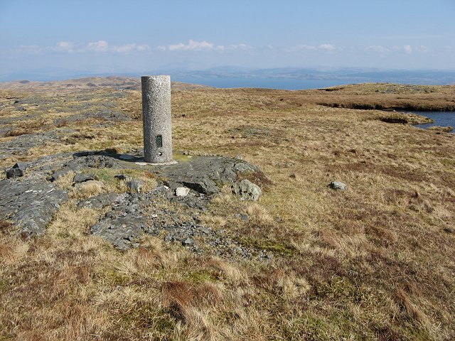
West ridge of Druim Fada beyond trig point The ridge extending to the west from the cylindrical, 'Vanessa style', trig point.
Creach Beinn is the mountain in the distance.
West ridge of Druim Fada beyond trig point
The ridge extending to the west from the cylindrical, 'Vanessa style', trig point. Creach Beinn is the mountain in the distance.
Seascape off Rubha na Codha, Mull
Port Ohirnie, Mull
Port Ohirnie, Mull
Allt an Tiadhain The Allt an Tiadhain drains a glen on the south side of the Laggan Forest. The land is mostly grass covered.
Allt an Tiadhain
The Allt an Tiadhain drains a glen on the south side of the Laggan Forest. The land is mostly grass covered.
Lochan na Croibhe-caoruinn The Rowan Loch is missing its tree now.  A lochan on Druim Fada.
Lochan na Croibhe-caoruinn
The Rowan Loch is missing its tree now. A lochan on Druim Fada.
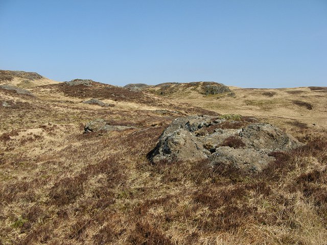
Laggan Forest The plateau of the Laggan Forest, the strange shaped peninsula on the south coast of Mull is mostly grassy with basalt outcrops.
Laggan Forest
The plateau of the Laggan Forest, the strange shaped peninsula on the south coast of Mull is mostly grassy with basalt outcrops.
Druim Fada Druim Fada is Laggan's highest hill at 405m. The south side is steep before rolling down to the Firth of Lorne. Below this scarp is a narrow lochan unnamed on the OS map.
Druim Fada
Druim Fada is Laggan's highest hill at 405m. The south side is steep before rolling down to the Firth of Lorne. Below this scarp is a narrow lochan unnamed on the OS map.
Druim Fada The flat summit of the peninsula with a vanessa trig pillar.
Druim Fada
The flat summit of the peninsula with a vanessa trig pillar.
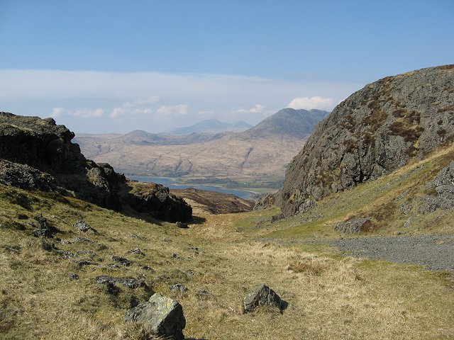
Creag Sgoite Crag on Druim Fada with an east descent route through a gap down to Loch Buie.
Creag Sgoite
Crag on Druim Fada with an east descent route through a gap down to Loch Buie.
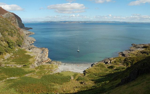
Anchorage, Port Ohirnie (Port Odhar), Isle of Mull The shoreline is stone and pebbles, but the ground in the anchorage is sand.  Holding appears to be good, with reasonable shelter from, clockwise, southwest to north.
Anchorage, Port Ohirnie (Port Odhar), Isle of Mull
The shoreline is stone and pebbles, but the ground in the anchorage is sand. Holding appears to be good, with reasonable shelter from, clockwise, southwest to north.
Waterfall, Allt Ohirnie
Ruined cottage, Port Ohirnie (Port Odhar) The remains of what was probably a small black house or bothy lie to the north side of the shoreline.  To the right is Rubha nam Fear, with the Garvellachs and Scarba in the background.
Ruined cottage, Port Ohirnie (Port Odhar)
The remains of what was probably a small black house or bothy lie to the north side of the shoreline. To the right is Rubha nam Fear, with the Garvellachs and Scarba in the background.
Rubha na Codha, from Port Ohirnie (Port Odhar)
Druim Fada Trig The trig point on the summit of Druim Fada.
Druim Fada Trig
The trig point on the summit of Druim Fada.
Rubha Aoineadh Mhéinis Below the cliffs of Aoineadh Mhéinis, the wave-cut platform sticks out an extra 150m at Rubha Aoineadh Mhéinis. There was not much swell when this photo was taken in very calm conditions under a high pressure system, somewhat after high tide on neaps, but still the waves are washing over the rocks. On a spring tide with the sort of swell that this wide part of the Firth of Lorn exposed to the southwest gets, the sea must crash over this whole promontory, readily explaining the complete lack of vegetation.
Rubha Aoineadh Mhéinis
Below the cliffs of Aoineadh Mhéinis, the wave-cut platform sticks out an extra 150m at Rubha Aoineadh Mhéinis. There was not much swell when this photo was taken in very calm conditions under a high pressure system, somewhat after high tide on neaps, but still the waves are washing over the rocks. On a spring tide with the sort of swell that this wide part of the Firth of Lorn exposed to the southwest gets, the sea must crash over this whole promontory, readily explaining the complete lack of vegetation.
Show me another place!

Rubha na Codha is located at Grid Ref: NM6420 (Lat: 56.32006, Lng: -5.8076799)

Unitary Authority: Argyll and Bute

Police Authority: Argyll and West Dunbartonshire

What 3 Words

///influence.mash.chops. Near Lochbuie, Argyll & Bute

Related Wikis

Firth of Lorn

The Firth of Lorn or Lorne (Scottish Gaelic: An Linne Latharnach) is the inlet of the sea between the south-east coast of the Isle of Mull and the mainland...

Loch Buie

Loch Buie (Scottish Gaelic: Locha Buidhe, meaning "yellow loch") is a sea loch on the south coast of the Isle of Mull, off the west coast of Scotland....

Moy Castle

Moy Castle is a ruined castle near Lochbuie on the Isle of Mull, Scotland. The site is now a scheduled monument. == History == The land upon which Moy...

Lochbuie, Mull

Lochbuie (Scottish Gaelic: Locha Buidhe, meaning "yellow loch") is a settlement on the Isle of Mull in Scotland about 22 kilometres (14 mi) west of Craignure...

Nearby Amenities

Located within 500m of 56.32006,-5.8076799
Created By: dmgroom_coastlines
Source: PGS
Lat/Long: 56.322918/-5.801896
Created By: dmgroom_coastlines
Source: PGS
Lat/Long: 56.322785/-5.802118
Created By: dmgroom_coastlines
Source: PGS
Lat/Long: 56.322651/-5.802338
Created By: dmgroom_coastlines
Source: PGS
Lat/Long: 56.322519/-5.802559
Created By: dmgroom_coastlines
Source: PGS
Lat/Long: 56.322385/-5.802779
Created By: dmgroom_coastlines
Source: PGS
Lat/Long: 56.322109/-5.803681
Created By: dmgroom_coastlines
Source: PGS
Lat/Long: 56.322098/-5.804141
Source: PGS
Lat/Long: 56.3220078/-5.8044072
Created By: dmgroom_coastlines
Source: PGS
Lat/Long: 56.321699/-5.804804
Created By: dmgroom_coastlines
Source: PGS
Lat/Long: 56.321566/-5.805024
Source: PGS
Lat/Long: 56.3212523/-5.8057201
Created By: dmgroom_coastlines
Source: PGS
Lat/Long: 56.321157/-5.806147
Created By: dmgroom_coastlines
Source: PGS
Lat/Long: 56.320901/-5.806129
Created By: dmgroom_coastlines
Source: PGS
Lat/Long: 56.320767/-5.806349
Created By: dmgroom_coastlines
Source: PGS
Lat/Long: 56.320635/-5.80657
Created By: dmgroom_coastlines
Source: PGS
Lat/Long: 56.320113/-5.806993
Created By: dmgroom_coastlines
Source: PGS
Lat/Long: 56.319979/-5.807213
Created By: dmgroom_coastlines
Source: PGS
Lat/Long: 56.319969/-5.807673
Created By: dmgroom_coastlines
Source: PGS
Lat/Long: 56.320002/-5.80798
Created By: dmgroom_coastlines
Source: PGS
Lat/Long: 56.319826/-5.808355
Created By: dmgroom_coastlines
Source: PGS
Lat/Long: 56.319692/-5.808575
Created By: dmgroom_coastlines
Source: PGS
Lat/Long: 56.319559/-5.808796
Source: PGS
Lat/Long: 56.3195531/-5.8093273
Source: PGS
Lat/Long: 56.319349/-5.8098219
Source: PGS
Lat/Long: 56.319089/-5.8108513
Source: PGS
Lat/Long: 56.3189602/-5.8114763
Source: PGS
Lat/Long: 56.3189932/-5.811869
The data included in this document is from www.openstreetmap.org. The data is made available under ODbL.

Have you been to Rubha na Codha?

Leave your review of Rubha na Codha below (or comments, questions and feedback).