An Sgonnag

Coastal Feature, Headland, Point in Argyllshire

Scotland

An Sgonnag

Port na Luinge A fine camp site
Port na Luinge Credit: GRAEME and LESLEY CRANSTON

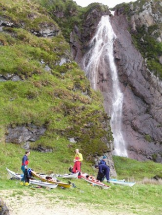
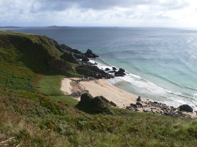
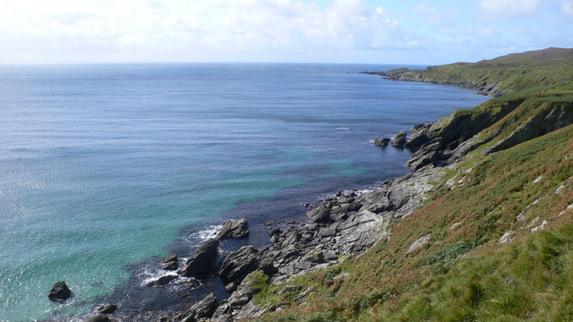
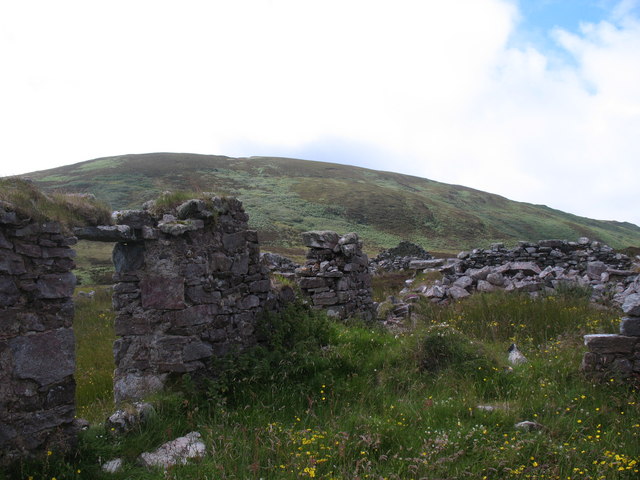
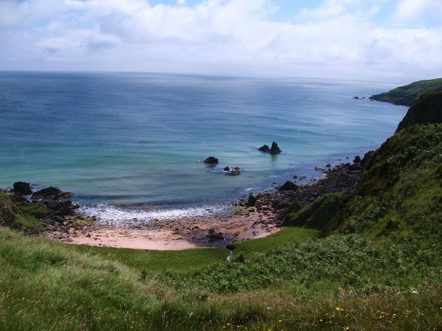
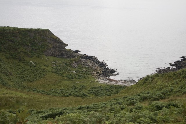
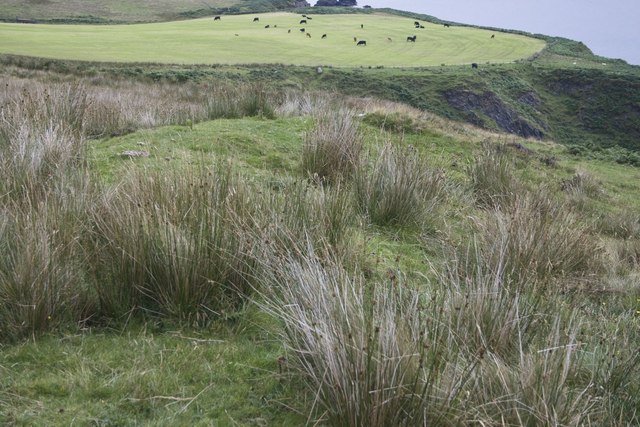
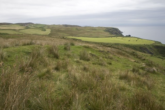
An Sgonnag is a prominent headland located in Argyllshire, Scotland. Situated on the western coast of the country, it juts out into the Atlantic Ocean, offering spectacular views of the surrounding landscape. With its rugged cliffs and rocky terrain, An Sgonnag is a striking coastal feature that attracts both locals and tourists alike.

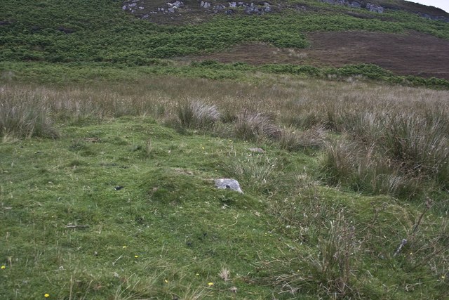
The headland is characterized by its steep slopes and high elevation, making it a prominent landmark in the area. The cliffs that line the coastline are composed of ancient rock formations, displaying layers of sedimentary deposits, providing a glimpse into the geological history of the region.

An Sgonnag is also known for its diverse wildlife. The surrounding waters host an abundance of marine life, including seals, dolphins, and various species of seabirds. Birdwatchers often flock to the headland to catch a glimpse of the resident puffins, gannets, and guillemots that nest on the cliffs.

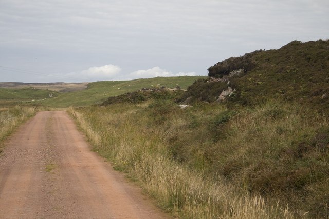
For outdoor enthusiasts, An Sgonnag offers excellent opportunities for hiking and exploration. There are several walking trails that wind their way along the headland, providing visitors with breathtaking panoramic views of the ocean and the surrounding countryside. The headland's location also makes it a popular spot for fishing, with anglers often casting their lines from the rocky shores.

Overall, An Sgonnag is a stunning coastal feature that showcases the natural beauty and diversity of the Argyllshire region. Its dramatic cliffs, diverse wildlife, and scenic views make it a must-visit destination for nature lovers and outdoor enthusiasts.

If you have any feedback on the listing, please let us know in the comments section below.
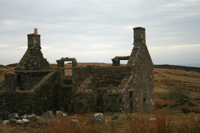
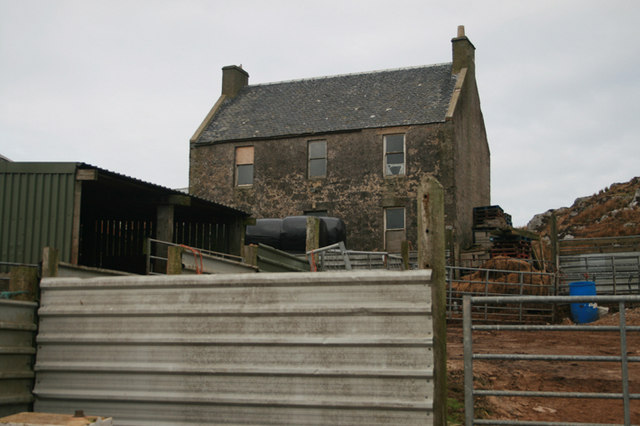
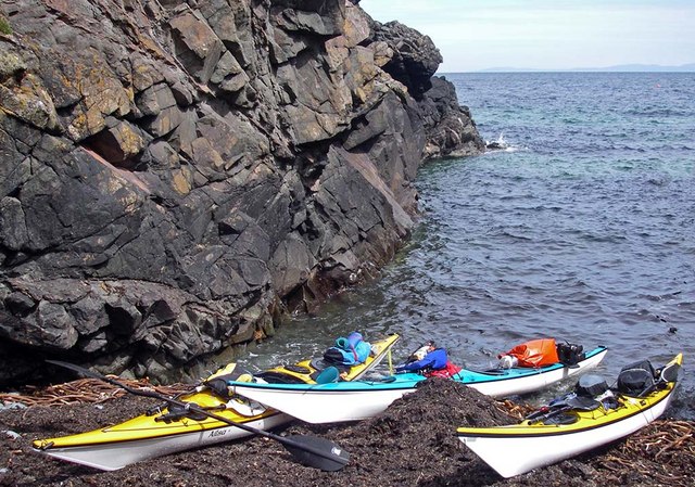
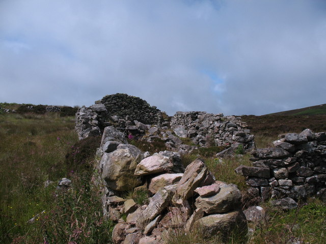
An Sgonnag Images

Images are sourced within 2km of 55.594873/-6.2357349 or Grid Reference NR3341. Thanks to Geograph Open Source API. All images are credited.

Port na Luinge A fine camp site
Port na Luinge
A fine camp site
South-east of Coillabus The view shows the stream flowing from the spring marked on the map as Tobar a' Chnoic Ghlas. Looking south-east into the moorland on the southern flanks of the Oa.
South-east of Coillabus
The view shows the stream flowing from the spring marked on the map as Tobar a' Chnoic Ghlas. Looking south-east into the moorland on the southern flanks of the Oa.
Lurabus, deserted settlement, Islay This settlement is regarded as being the largest and best preserved of the numerous deserted settlements in The Oa area of Islay.  

It is believed to have been settled in from 1700 onwards but the remains still there today cannot be dated further back than 1800.  It seems that the settlement was deserted by the third quarter of that century.
Lurabus, deserted settlement, Islay
This settlement is regarded as being the largest and best preserved of the numerous deserted settlements in The Oa area of Islay. It is believed to have been settled in from 1700 onwards but the remains still there today cannot be dated further back than 1800. It seems that the settlement was deserted by the third quarter of that century.
Looking on to the bay at Port an Eas
Coastline south-west of Rubha Dubh Alt a' Mhadaidh
Eas Mòr Waterfall, Port an Eas, Islay The name means 'big waterfall' but this was taken after a spell of dry weather!
Eas Mòr Waterfall, Port an Eas, Islay
The name means 'big waterfall' but this was taken after a spell of dry weather!
Inveraval, Islay This ruined cottage is situated on the south-east corner of the Oa peninsula. See <a href="https://www.geograph.org.uk/photo/2570071">NR3242 : Inveraval, Islay</a> for photo of the renovated property.
Inveraval, Islay
This ruined cottage is situated on the south-east corner of the Oa peninsula. See NR3242 : Inveraval, Islay for photo of the renovated property.
Ballychatrigan Farm, Islay A derelict farm on the Oa Peninsula.
Ballychatrigan Farm, Islay
A derelict farm on the Oa Peninsula.
Rubha na h-Uamha Rocky gully near Rubha na h-Uamha, access only from the sea.
Rubha na h-Uamha
Rocky gully near Rubha na h-Uamha, access only from the sea.
Ruined settlement, Uchdach na Coille Ruined settlement on the east side of the Oa peninsula. Islay was 'improved' in the late 18th and early 19th centuries with planned villages and a modernised farming system, but it is difficult to know if settlements like this were cleared or whether the people just drifted away.
Ruined settlement, Uchdach na Coille
Ruined settlement on the east side of the Oa peninsula. Islay was 'improved' in the late 18th and early 19th centuries with planned villages and a modernised farming system, but it is difficult to know if settlements like this were cleared or whether the people just drifted away.
Ruined dwellings, Tornamoine Situated between the moor and the sea cliffs, this abandoned settlement must once have provided a living from agriculture. A ruined corn drying kiln stands nearby.
Ruined dwellings, Tornamoine
Situated between the moor and the sea cliffs, this abandoned settlement must once have provided a living from agriculture. A ruined corn drying kiln stands nearby.
Port an Eas Secluded sandy bay on the east side of the Oa.
Port an Eas
Secluded sandy bay on the east side of the Oa.
Lurabus, Islay
Lurabus, Islay
Port Asabuis, Islay
Port Asabuis, Islay
Track to Ballychatrigan, Islay
Ruins of Cill Choman, Islay All that now remains of an ancient chapel/monastery. The last visit by RCAHMS appears to be 1981 and there is even less remaining now.

Information from <span class="nowrap"><a title="www.scotlandsplaces.gov.uk:" rel="nofollow ugc noopener" href="http://www.scotlandsplaces.gov.uk:">Link</a><img style="margin-left:2px;" alt="External link" title="External link - shift click to open in new window" src="https://s1.geograph.org.uk/img/external.png" width="10" height="10"/></span>

Merest indications of the chapel walls appears above the turf. It has measured about 18ft by 8ft and stands in an enclosure about 60ft by 30ft. 
R C Graham 1895. 

The name of this chapel was first collected as "Cill a' Chobhain" and later changed to the published version. It may therefore be the "Kilachoan" planned by Mrs Lucy Ramsay before 1890 (Celoria 1959); and also the Kilchoan mentioned by Watson (1926) as deriving from Cill Chomtighain, the church of St Comgan, possibly an 8th century saint. There is a local tradition that it was a monastery (Celoria 1960). 
Name Book 1878; F Celoria 1959; 1960; W J Watson 1926; F Gold 1961. 

NR 3147 4115 The remains of a chapel measuring 9m north west-south east by 6m over walling 1m high and 1.5m wide is situated within a rectangular burial ground 25m by 10m. There is a probable entrance 0.6m wide in the north east side of the chapel. 
Surveyed at 1:10000. 
Visited by OS (BS) 3 June 1978.

This chapel is situated on a south-facing hillside some 300m w of the boat-landing at Port Asabuis and at an elevation of 65m OD. Much of the surrounding land shows traces of rig-cultivation, and the remains of a small settlement are
identifiable some 75m to the W, The chapel measures 6.3m from E to W by 3.1m transversely within walls about 1m in thickness which, although heather-grown, stand to a height of about 0.9m. Much of the masonry-facing survives, but there are no identifiable traces of mortar. The apparent narrowness of the entrance, which is placed towards the middle of the N wall, may be the result of tumbled masonry.
The building stands within a subrectangular enclosure measuring about 24m from E to why 11m, which appears to
have been subdivided by slighter walls in line with the E wall of the chapel. The boundary-wall is preserved in places to a height of 0.8m and displays several stretches of masonry facework. At the E end of the site, where the wall ran along
the edge of a rocky scarp, it was supported by substantial stone revetments.
The dedication of the chapel was probably to St Comgan. (Watson 1926)
Visited March 1981
RCAHMS 1984
Ruins of Cill Choman, Islay
All that now remains of an ancient chapel/monastery. The last visit by RCAHMS appears to be 1981 and there is even less remaining now. Information from LinkExternal link Merest indications of the chapel walls appears above the turf. It has measured about 18ft by 8ft and stands in an enclosure about 60ft by 30ft. R C Graham 1895. The name of this chapel was first collected as "Cill a' Chobhain" and later changed to the published version. It may therefore be the "Kilachoan" planned by Mrs Lucy Ramsay before 1890 (Celoria 1959); and also the Kilchoan mentioned by Watson (1926) as deriving from Cill Chomtighain, the church of St Comgan, possibly an 8th century saint. There is a local tradition that it was a monastery (Celoria 1960). Name Book 1878; F Celoria 1959; 1960; W J Watson 1926; F Gold 1961. NR 3147 4115 The remains of a chapel measuring 9m north west-south east by 6m over walling 1m high and 1.5m wide is situated within a rectangular burial ground 25m by 10m. There is a probable entrance 0.6m wide in the north east side of the chapel. Surveyed at 1:10000. Visited by OS (BS) 3 June 1978. This chapel is situated on a south-facing hillside some 300m w of the boat-landing at Port Asabuis and at an elevation of 65m OD. Much of the surrounding land shows traces of rig-cultivation, and the remains of a small settlement are identifiable some 75m to the W, The chapel measures 6.3m from E to W by 3.1m transversely within walls about 1m in thickness which, although heather-grown, stand to a height of about 0.9m. Much of the masonry-facing survives, but there are no identifiable traces of mortar. The apparent narrowness of the entrance, which is placed towards the middle of the N wall, may be the result of tumbled masonry. The building stands within a subrectangular enclosure measuring about 24m from E to why 11m, which appears to have been subdivided by slighter walls in line with the E wall of the chapel. The boundary-wall is preserved in places to a height of 0.8m and displays several stretches of masonry facework. At the E end of the site, where the wall ran along the edge of a rocky scarp, it was supported by substantial stone revetments. The dedication of the chapel was probably to St Comgan. (Watson 1926) Visited March 1981 RCAHMS 1984
Cill Choman, Islay All that now remains of an ancient chapel/monastery. The last visit by RCAHMS appears to be 1981 and there is even less remaining now.

Information from <span class="nowrap"><a title="www.scotlandsplaces.gov.uk:" rel="nofollow ugc noopener" href="http://www.scotlandsplaces.gov.uk:">Link</a><img style="margin-left:2px;" alt="External link" title="External link - shift click to open in new window" src="https://s1.geograph.org.uk/img/external.png" width="10" height="10"/></span>

Merest indications of the chapel walls appears above the turf. It has measured about 18ft by 8ft and stands in an enclosure about 60ft by 30ft. 
R C Graham 1895. 

The name of this chapel was first collected as "Cill a' Chobhain" and later changed to the published version. It may therefore be the "Kilachoan" planned by Mrs Lucy Ramsay before 1890 (Celoria 1959); and also the Kilchoan mentioned by Watson (1926) as deriving from Cill Chomtighain, the church of St Comgan, possibly an 8th century saint. There is a local tradition that it was a monastery (Celoria 1960). 
Name Book 1878; F Celoria 1959; 1960; W J Watson 1926; F Gold 1961. 

NR 3147 4115 The remains of a chapel measuring 9m north west-south east by 6m over walling 1m high and 1.5m wide is situated within a rectangular burial ground 25m by 10m. There is a probable entrance 0.6m wide in the north east side of the chapel. 
Surveyed at 1:10000. 
Visited by OS (BS) 3 June 1978.

This chapel is situated on a south-facing hillside some 300m w of the boat-landing at Port Asabuis and at an elevation of 65m OD. Much of the surrounding land shows traces of rig-cultivation, and the remains of a small settlement are
identifiable some 75m to the W, The chapel measures 6.3m from E to W by 3.1m transversely within walls about 1m in thickness which, although heather-grown, stand to a height of about 0.9m. Much of the masonry-facing survives, but there are no identifiable traces of mortar. The apparent narrowness of the entrance, which is placed towards the middle of the N wall, may be the result of tumbled masonry.
The building stands within a subrectangular enclosure measuring about 24m from E to why 11m, which appears to
have been subdivided by slighter walls in line with the E wall of the chapel. The boundary-wall is preserved in places to a height of 0.8m and displays several stretches of masonry facework. At the E end of the site, where the wall ran along
the edge of a rocky scarp, it was supported by substantial stone revetments.
The dedication of the chapel was probably to St Comgan. (Watson 1926)
Visited March 1981
RCAHMS 1984
Cill Choman, Islay
All that now remains of an ancient chapel/monastery. The last visit by RCAHMS appears to be 1981 and there is even less remaining now. Information from LinkExternal link Merest indications of the chapel walls appears above the turf. It has measured about 18ft by 8ft and stands in an enclosure about 60ft by 30ft. R C Graham 1895. The name of this chapel was first collected as "Cill a' Chobhain" and later changed to the published version. It may therefore be the "Kilachoan" planned by Mrs Lucy Ramsay before 1890 (Celoria 1959); and also the Kilchoan mentioned by Watson (1926) as deriving from Cill Chomtighain, the church of St Comgan, possibly an 8th century saint. There is a local tradition that it was a monastery (Celoria 1960). Name Book 1878; F Celoria 1959; 1960; W J Watson 1926; F Gold 1961. NR 3147 4115 The remains of a chapel measuring 9m north west-south east by 6m over walling 1m high and 1.5m wide is situated within a rectangular burial ground 25m by 10m. There is a probable entrance 0.6m wide in the north east side of the chapel. Surveyed at 1:10000. Visited by OS (BS) 3 June 1978. This chapel is situated on a south-facing hillside some 300m w of the boat-landing at Port Asabuis and at an elevation of 65m OD. Much of the surrounding land shows traces of rig-cultivation, and the remains of a small settlement are identifiable some 75m to the W, The chapel measures 6.3m from E to W by 3.1m transversely within walls about 1m in thickness which, although heather-grown, stand to a height of about 0.9m. Much of the masonry-facing survives, but there are no identifiable traces of mortar. The apparent narrowness of the entrance, which is placed towards the middle of the N wall, may be the result of tumbled masonry. The building stands within a subrectangular enclosure measuring about 24m from E to why 11m, which appears to have been subdivided by slighter walls in line with the E wall of the chapel. The boundary-wall is preserved in places to a height of 0.8m and displays several stretches of masonry facework. At the E end of the site, where the wall ran along the edge of a rocky scarp, it was supported by substantial stone revetments. The dedication of the chapel was probably to St Comgan. (Watson 1926) Visited March 1981 RCAHMS 1984
Ruins of Cill Choman, Islay All that now remains of an ancient chapel/monastery. The last visit by RCAHMS appears to be 1981 and there is even less remaining now.

Information from <span class="nowrap"><a title="www.scotlandsplaces.gov.uk:" rel="nofollow ugc noopener" href="http://www.scotlandsplaces.gov.uk:">Link</a><img style="margin-left:2px;" alt="External link" title="External link - shift click to open in new window" src="https://s1.geograph.org.uk/img/external.png" width="10" height="10"/></span>

Merest indications of the chapel walls appears above the turf. It has measured about 18ft by 8ft and stands in an enclosure about 60ft by 30ft. 
R C Graham 1895. 

The name of this chapel was first collected as "Cill a' Chobhain" and later changed to the published version. It may therefore be the "Kilachoan" planned by Mrs Lucy Ramsay before 1890 (Celoria 1959); and also the Kilchoan mentioned by Watson (1926) as deriving from Cill Chomtighain, the church of St Comgan, possibly an 8th century saint. There is a local tradition that it was a monastery (Celoria 1960). 
Name Book 1878; F Celoria 1959; 1960; W J Watson 1926; F Gold 1961. 

NR 3147 4115 The remains of a chapel measuring 9m north west-south east by 6m over walling 1m high and 1.5m wide is situated within a rectangular burial ground 25m by 10m. There is a probable entrance 0.6m wide in the north east side of the chapel. 
Surveyed at 1:10000. 
Visited by OS (BS) 3 June 1978.

This chapel is situated on a south-facing hillside some 300m w of the boat-landing at Port Asabuis and at an elevation of 65m OD. Much of the surrounding land shows traces of rig-cultivation, and the remains of a small settlement are
identifiable some 75m to the W, The chapel measures 6.3m from E to W by 3.1m transversely within walls about 1m in thickness which, although heather-grown, stand to a height of about 0.9m. Much of the masonry-facing survives, but there are no identifiable traces of mortar. The apparent narrowness of the entrance, which is placed towards the middle of the N wall, may be the result of tumbled masonry.
The building stands within a subrectangular enclosure measuring about 24m from E to why 11m, which appears to
have been subdivided by slighter walls in line with the E wall of the chapel. The boundary-wall is preserved in places to a height of 0.8m and displays several stretches of masonry facework. At the E end of the site, where the wall ran along
the edge of a rocky scarp, it was supported by substantial stone revetments.
The dedication of the chapel was probably to St Comgan. (Watson 1926)
Visited March 1981
RCAHMS 1984
Ruins of Cill Choman, Islay
All that now remains of an ancient chapel/monastery. The last visit by RCAHMS appears to be 1981 and there is even less remaining now. Information from LinkExternal link Merest indications of the chapel walls appears above the turf. It has measured about 18ft by 8ft and stands in an enclosure about 60ft by 30ft. R C Graham 1895. The name of this chapel was first collected as "Cill a' Chobhain" and later changed to the published version. It may therefore be the "Kilachoan" planned by Mrs Lucy Ramsay before 1890 (Celoria 1959); and also the Kilchoan mentioned by Watson (1926) as deriving from Cill Chomtighain, the church of St Comgan, possibly an 8th century saint. There is a local tradition that it was a monastery (Celoria 1960). Name Book 1878; F Celoria 1959; 1960; W J Watson 1926; F Gold 1961. NR 3147 4115 The remains of a chapel measuring 9m north west-south east by 6m over walling 1m high and 1.5m wide is situated within a rectangular burial ground 25m by 10m. There is a probable entrance 0.6m wide in the north east side of the chapel. Surveyed at 1:10000. Visited by OS (BS) 3 June 1978. This chapel is situated on a south-facing hillside some 300m w of the boat-landing at Port Asabuis and at an elevation of 65m OD. Much of the surrounding land shows traces of rig-cultivation, and the remains of a small settlement are identifiable some 75m to the W, The chapel measures 6.3m from E to W by 3.1m transversely within walls about 1m in thickness which, although heather-grown, stand to a height of about 0.9m. Much of the masonry-facing survives, but there are no identifiable traces of mortar. The apparent narrowness of the entrance, which is placed towards the middle of the N wall, may be the result of tumbled masonry. The building stands within a subrectangular enclosure measuring about 24m from E to why 11m, which appears to have been subdivided by slighter walls in line with the E wall of the chapel. The boundary-wall is preserved in places to a height of 0.8m and displays several stretches of masonry facework. At the E end of the site, where the wall ran along the edge of a rocky scarp, it was supported by substantial stone revetments. The dedication of the chapel was probably to St Comgan. (Watson 1926) Visited March 1981 RCAHMS 1984
Show me another place!

An Sgonnag is located at Grid Ref: NR3341 (Lat: 55.594873, Lng: -6.2357349)

Unitary Authority: Argyll and Bute

Police Authority: Argyll and West Dunbartonshire

What 3 Words

///overt.setting.masses. Near Port Ellen, Argyll & Bute

Related Wikis

The Oa

The Oa ( OH) (Scottish Gaelic: An Obha) is a rocky peninsula in the southwest of the island of Islay, in Argyll, Scotland. It is an RSPB nature reserve...
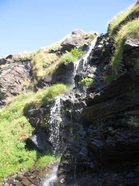
Eas Mòr, upper

Eas Mor is a waterfall is a waterfall on the Abhainn Ghil on the island of Islay in Scotland. It lies on The Oa peninsula south of Giol and west of Lenavore...

St John's Church, Port Ellen

St John's Church, Port Ellen is a Category B listed building in Port Ellen, Islay, Argyll and Bute, Scotland. == History == The memorial stone for the...

Port Ellen distillery

Port Ellen distillery is located in Port Ellen on the isle of Islay, Scotland. Port Ellen distillery reopened in 2024 after being closed since 1983....

Have you been to An Sgonnag?

Leave your review of An Sgonnag below (or comments, questions and feedback).