Coran an Dubh Thòb

Coastal Feature, Headland, Point in Ross-shire

Scotland

Coran an Dubh Thòb

Croft near Breasclete
Croft near Breasclete Credit: David Dixon

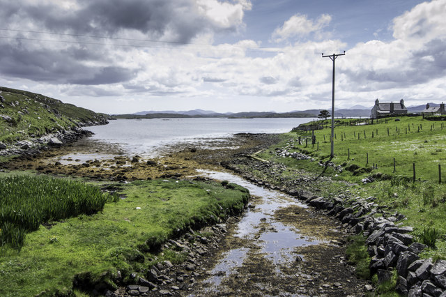
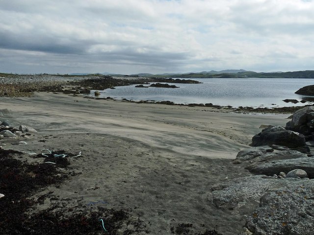
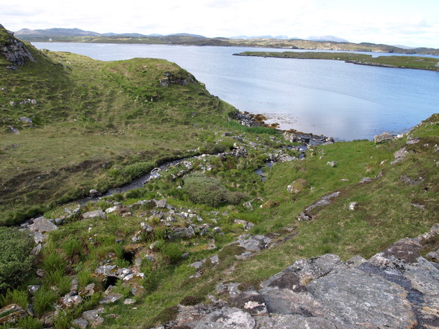
Coran an Dubh Thòb, located in Ross-shire, Scotland, is a prominent coastal feature that stretches out into the North Atlantic Ocean. Also known as Corran Point or Black Point in English, it is a headland that juts out into the sea, forming a distinctive shape on the coastline.

This geological formation is characterized by its rugged cliffs, which rise dramatically from the water, creating a stunning and picturesque landscape. The headland is composed of a variety of rock types, including ancient sedimentary rocks and volcanic formations, which have been shaped by years of erosion from the powerful waves and winds of the ocean.

Coran an Dubh Thòb is known for its rich biodiversity and serves as a habitat for a diverse range of marine and bird species. The surrounding waters are teeming with marine life, including seals, dolphins, and various species of fish. Birdwatchers can also spot an array of seabirds, such as gannets, fulmars, and puffins, nesting and foraging along the cliffs.

The headland offers breathtaking views of the surrounding coastline and the open sea. It is a popular spot for nature enthusiasts, photographers, and hikers, who are drawn to its natural beauty and the opportunity to explore the rugged terrain. Visitors can enjoy coastal walks, taking in the fresh sea air and admiring the dramatic coastal scenery.

Overall, Coran an Dubh Thòb is a remarkable coastal feature that showcases the raw power of nature and provides a haven for diverse wildlife. It is a must-visit destination for anyone seeking an immersive experience in Scotland's coastal landscapes.

If you have any feedback on the listing, please let us know in the comments section below.

Coran an Dubh Thòb Images

Images are sourced within 2km of 58.221962/-6.7900041 or Grid Reference NB1835. Thanks to Geograph Open Source API. All images are credited.

Croft near Breasclete
House on a hill near Breasclete
Craft workshop in Kirkibost One of the old shellfish processing factories at Kirkibost (Circeabost) is now reborn as a craftshop.
Craft workshop in Kirkibost
One of the old shellfish processing factories at Kirkibost (Circeabost) is now reborn as a craftshop.
Cleibh ghiomaich aig cidhe Chirceabost Lobster creels at Kirkibost harbour
Cleibh ghiomaich aig cidhe Chirceabost
Lobster creels at Kirkibost harbour
Port a' Chaoil Stream flowing from Loch a' Bhaile enters Loch Rog an Ear, a sea loch, at Aird na Moine.
Port a' Chaoil
Stream flowing from Loch a' Bhaile enters Loch Rog an Ear, a sea loch, at Aird na Moine.
View towards Circebost Pier
Tolstachaolais: hillside cows and Bernera view Looking across the sound separating the eastern side of Bernera from the Lewis mainland, beyond three cows grazing on the slopes to the south of Tolstachaolais village.
Tolstachaolais: hillside cows and Bernera view
Looking across the sound separating the eastern side of Bernera from the Lewis mainland, beyond three cows grazing on the slopes to the south of Tolstachaolais village.
Outlet from Loch a' Bhaile into Port a' Chaoil At the crofting community of Tolastadh a' Chaolais.
Outlet from Loch a' Bhaile into Port a' Chaoil
At the crofting community of Tolastadh a' Chaolais.
Cnoc Feoal Part of the crofting community of Tolastadh a' Chaolais on the shores of Loch Ròg an Ear.
Cnoc Feoal
Part of the crofting community of Tolastadh a' Chaolais on the shores of Loch Ròg an Ear.
Loch a' Bhaile becomes the sea
Tràigh Shanndaig, Isle of Lewis Tràigh Shanndaig is a small beach on Loch Ròg an Ear.
Tràigh Shanndaig, Isle of Lewis
Tràigh Shanndaig is a small beach on Loch Ròg an Ear.
Croftland, Circebost, Great Bernera Looking across Loch Ròg an Ear (East Loch Roag) towards Eilean Chearstaigh.
Croftland, Circebost, Great Bernera
Looking across Loch Ròg an Ear (East Loch Roag) towards Eilean Chearstaigh.
Lazy beds below Cnoc Righseodh, Great Bernera/Beàrnaraigh
Calanais/Callanish XV, Circebost, Great Bernera/Beàrnaraigh From Discovery and Excavation in Scotland, 1976: "On grassy ridge 100m N of road, 25m E of track through Croft 24, Kirkibost. A large prone slab approx. 3.55m x 1.35m, thickness varying from 0.25-0.45m, lying in peat on a grassy ridge. The lower end appears to be surrounded by packing stones and there is a void under the centre of the stone. This stone was brought to our notice by Mr Norman MacDonald of Kirkibost."
Calanais/Callanish XV, Circebost, Great Bernera/Beàrnaraigh
From Discovery and Excavation in Scotland, 1976: "On grassy ridge 100m N of road, 25m E of track through Croft 24, Kirkibost. A large prone slab approx. 3.55m x 1.35m, thickness varying from 0.25-0.45m, lying in peat on a grassy ridge. The lower end appears to be surrounded by packing stones and there is a void under the centre of the stone. This stone was brought to our notice by Mr Norman MacDonald of Kirkibost."
Possible fallen standing stone, Circebost, Great Bernera/Beàrnaraigh This stone lies approximately 80m ESE of <a href="https://www.geograph.org.uk/photo/5293759">NB1734 : Calanais/Callanish XV, Circebost, Great Bernera/Beàrnaraigh</a>.  The croft owner, who is the grandson of Norman MacDonald who originally brought Callanish XV to archaeologists' attention, believes it to be fallen standing stone.
Possible fallen standing stone, Circebost, Great Bernera/Beàrnaraigh
This stone lies approximately 80m ESE of NB1734 : Calanais/Callanish XV, Circebost, Great Bernera/Beàrnaraigh. The croft owner, who is the grandson of Norman MacDonald who originally brought Callanish XV to archaeologists' attention, believes it to be fallen standing stone.
Looking down at Circebost Circebost or Kirkibost is a tiny settlement on Great Bernera. This island is now connected to Lewis by a short pre-stressed concrete bridge. In 1953 when it was built it was and remains the first bridge of such material in Europe.  

The settlemenr is also important as it is the first planned crofting township in the Outer Hebrides, though I think town is a lofty description for such a small group of houses.
Looking down at Circebost
Circebost or Kirkibost is a tiny settlement on Great Bernera. This island is now connected to Lewis by a short pre-stressed concrete bridge. In 1953 when it was built it was and remains the first bridge of such material in Europe. The settlemenr is also important as it is the first planned crofting township in the Outer Hebrides, though I think town is a lofty description for such a small group of houses.
Abhainn na Muilne Allt na Muilne, outflow of Loch na Muilne into Port a' Chaoil
(Loch Ròg an Ear). There are 2 ruined "Norse Mills" visible on this burn:
the lower one in the centre of the picture, the upper one near the down left corner.
Abhainn na Muilne
Allt na Muilne, outflow of Loch na Muilne into Port a' Chaoil (Loch Ròg an Ear). There are 2 ruined "Norse Mills" visible on this burn: the lower one in the centre of the picture, the upper one near the down left corner.
End of the road at Tobhtaral Two houses at the end of the road in the SE corner of Great Bernera island.
End of the road at Tobhtaral
Two houses at the end of the road in the SE corner of Great Bernera island.
Show me another place!

Coran an Dubh Thòb is located at Grid Ref: NB1835 (Lat: 58.221962, Lng: -6.7900041)

Unitary Authority: Na h-Eileanan an Iar

Police Authority: Highlands and Islands

What 3 Words

///deputy.scatter.strutted. Near Carloway, Na h-Eileanan Siar

Related Wikis

Ceabhaigh

Ceabhaigh is a small island in an arm of Loch Ròg on the west coast of Lewis in the Outer Hebrides of Scotland. It is about 25 hectares (62 acres) in extent...

Tolsta Chaolais

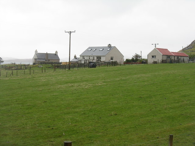
Tolsta Chaolais (also Tolastadh Chaolais, Tolstadh a' Chaolais) is a village on the Isle of Lewis, Scotland. It consists of about forty houses, clustered...

Eilean Chearstaidh

Eilean Kearstay (Scottish Gaelic: Eilean Chearstaigh) is an uninhabited island in Loch Roag in the Outer Hebrides of Scotland. It lies south east of Great...

Callanish VIII

The Callanish VIII stone setting is one of many megalithic structures around the better-known (and larger) Calanais I on the west coast of the Isle of...

Nearby Amenities

Located within 500m of 58.221962,-6.7900041
Leisure: slipway
Source: Bing
Lat/Long: 58.2233329/-6.7974459
Passing Place
Lat/Long: 58.2182459/-6.7933761
Power: pole
Lat/Long: 58.2192293/-6.7964477
Power: pole
Lat/Long: 58.2189298/-6.795775
Power: pole
Lat/Long: 58.2185078/-6.7946713
Power: pole
Lat/Long: 58.2181499/-6.7937933
Power: pole
Lat/Long: 58.2181428/-6.7927971
Power: pole
Lat/Long: 58.218697/-6.7931304
Power: pole
Lat/Long: 58.219235/-6.7934482
Power: pole
Lat/Long: 58.2177232/-6.7920057
Turning Circle
Lat/Long: 58.220998/-6.7980806
Power: pole
Lat/Long: 58.2192617/-6.7937361
Power: pole
Lat/Long: 58.2177996/-6.7913182
Tob a´Cheosan
Natural: bay
Lat/Long: 58.2204043/-6.7925253
The data included in this document is from www.openstreetmap.org. The data is made available under ODbL.

Have you been to Coran an Dubh Thòb?

Leave your review of Coran an Dubh Thòb below (or comments, questions and feedback).