Tom Raineach

Coastal Feature, Headland, Point in Ross-shire

Scotland

Tom Raineach

Old hardstandings at Tob Blar Meadha Abandoned lobster loading hardstandings at the lobster pond.
Old hardstandings at Tob Blar Meadha Credit: Gus Macdonald

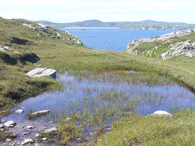
Tom Raineach is a coastal feature located in Ross-shire, Scotland. It is classified as a headland or point due to its prominent and elongated landform jutting out into the sea. The name "Tom Raineach" is derived from Scottish Gaelic and translates to "fern-covered hillock," which accurately describes its appearance.

Situated along the rugged coastline of Ross-shire, Tom Raineach offers breathtaking views of the surrounding seascape. Its elevated position makes it an ideal vantage point to observe the crashing waves, rocky cliffs, and the vast expanse of the ocean. The headland is characterized by its steep slopes and jagged cliffs, which have been shaped by the relentless forces of erosion over time.

Tom Raineach is rich in biodiversity, serving as a habitat for various coastal plants and wildlife. The presence of ferns, as suggested by its name, adds to the diversity of vegetation found here. The headland is home to several species of seabirds, such as gulls and cormorants, which nest and roost on the cliff faces.

Due to its stunning natural beauty and ecological importance, Tom Raineach attracts visitors who enjoy outdoor activities such as hiking, birdwatching, and photography. The headland provides an opportunity to explore and appreciate the dramatic coastal landscapes of Ross-shire. Additionally, its proximity to other notable landmarks and attractions in the area, such as the village of Ullapool and the North Coast 500 route, further enhances its appeal to tourists.

In conclusion, Tom Raineach is a remarkable coastal feature in Ross-shire, Scotland, known for its striking appearance, diverse flora and fauna, and stunning views of the surrounding coastline. It is a destination that offers both natural beauty and recreational opportunities for visitors to enjoy.

If you have any feedback on the listing, please let us know in the comments section below.

Tom Raineach Images

Images are sourced within 2km of 58.234361/-6.8420613 or Grid Reference NB1537. Thanks to Geograph Open Source API. All images are credited.

Old hardstandings at Tob Blar Meadha Abandoned lobster loading hardstandings at the lobster pond.
Old hardstandings at Tob Blar Meadha
Abandoned lobster loading hardstandings at the lobster pond.
West coast of Great Bernera This is the west side of a spit of land extending south of Tobson. The ground is rocky with a thin covering of grass.

In the distance, on the left is the tip of the island of Pabaigh Mor .. and on the right Geodha Mor (west of Tobson).
West coast of Great Bernera
This is the west side of a spit of land extending south of Tobson. The ground is rocky with a thin covering of grass. In the distance, on the left is the tip of the island of Pabaigh Mor .. and on the right Geodha Mor (west of Tobson).
Beach north of Bhalasaigh
Sea loch west of Loch Veiravat Although it isn't obvious from here, this is the start of a long channel that leads out to the sea.
Sea loch west of Loch Veiravat
Although it isn't obvious from here, this is the start of a long channel that leads out to the sea.
Moorland and loch on Great Bernera The loch is unnamed on the map, but the Allt Loch an Fheoir flows into it, so this must be Loch an Fheoir.

The houses in the distance are on the road south of Bhalasaigh.
Moorland and loch on Great Bernera
The loch is unnamed on the map, but the Allt Loch an Fheoir flows into it, so this must be Loch an Fheoir. The houses in the distance are on the road south of Bhalasaigh.
Waymarked coastal walk There are clear waymarks on the route from the community centre to Bosta on Great Bernera. Return by the same route or on the road.
Waymarked coastal walk
There are clear waymarks on the route from the community centre to Bosta on Great Bernera. Return by the same route or on the road.
Bridge at Bhalasaigh Looking back to the road end on the main island of Great Bernera.
Bridge at Bhalasaigh
Looking back to the road end on the main island of Great Bernera.
West coast of Great Bernera A complicated coastline with many interesting features.
West coast of Great Bernera
A complicated coastline with many interesting features.
War Memorial, Breacleit The memorial stands on a mound at the crossroads in the centre of Breacleit / Breaclete, the capital of Great Bernera / Bearnaraigh. On the skyline is the Bernera Community Centre.
<span class="nowrap"><a title="http://www.uigandbernera.com/" rel="nofollow ugc noopener" href="http://www.uigandbernera.com/">Link</a><img style="margin-left:2px;" alt="External link" title="External link - shift click to open in new window" src="https://s1.geograph.org.uk/img/external.png" width="10" height="10"/></span>
War Memorial, Breacleit
The memorial stands on a mound at the crossroads in the centre of Breacleit / Breaclete, the capital of Great Bernera / Bearnaraigh. On the skyline is the Bernera Community Centre. LinkExternal link
Breacleit, Bernera Summer flowers, church and school in the village centre.
<span class="nowrap"><a title="http://www.uigandbernera.com/" rel="nofollow ugc noopener" href="http://www.uigandbernera.com/">Link</a><img style="margin-left:2px;" alt="External link" title="External link - shift click to open in new window" src="https://s1.geograph.org.uk/img/external.png" width="10" height="10"/></span>
Breacleit, Bernera
Summer flowers, church and school in the village centre. LinkExternal link
Loch Ionail Freshwater loch on the island of Great Bernera / Bearnaraigh.
<span class="nowrap"><a title="http://www.uigandbernera.com/" rel="nofollow ugc noopener" href="http://www.uigandbernera.com/">Link</a><img style="margin-left:2px;" alt="External link" title="External link - shift click to open in new window" src="https://s1.geograph.org.uk/img/external.png" width="10" height="10"/></span>
Loch Ionail
Freshwater loch on the island of Great Bernera / Bearnaraigh. LinkExternal link
Tob Bhalasaigh Tidal lagoon with a mix of rare seaweeds on Great Bernera / Bearnaraigh.
<span class="nowrap"><a title="http://www.uigandbernera.com/" rel="nofollow ugc noopener" href="http://www.uigandbernera.com/">Link</a><img style="margin-left:2px;" alt="External link" title="External link - shift click to open in new window" src="https://s1.geograph.org.uk/img/external.png" width="10" height="10"/></span>
Tob Bhalasaigh
Tidal lagoon with a mix of rare seaweeds on Great Bernera / Bearnaraigh. LinkExternal link
Valasay Bridge Carrying the single track road across an outlet of the tidal lagoon, Tob Bhalasaigh on Great Bernera / Bearnaraigh.
<span class="nowrap"><a title="http://www.uigandbernera.com/" rel="nofollow ugc noopener" href="http://www.uigandbernera.com/">Link</a><img style="margin-left:2px;" alt="External link" title="External link - shift click to open in new window" src="https://s1.geograph.org.uk/img/external.png" width="10" height="10"/></span>
Valasay Bridge
Carrying the single track road across an outlet of the tidal lagoon, Tob Bhalasaigh on Great Bernera / Bearnaraigh. LinkExternal link
Shoreline at Tob Bhalasaigh Rocks and heather at the edge of the tidal lagoon in Valasay.
<span class="nowrap"><a title="http://www.uigandbernera.com/" rel="nofollow ugc noopener" href="http://www.uigandbernera.com/">Link</a><img style="margin-left:2px;" alt="External link" title="External link - shift click to open in new window" src="https://s1.geograph.org.uk/img/external.png" width="10" height="10"/></span>
Shoreline at Tob Bhalasaigh
Rocks and heather at the edge of the tidal lagoon in Valasay. LinkExternal link
Valasay Footbridge The bridge across the tidal Tob Bhalasaigh was built in 1898.
<span class="nowrap"><a title="http://www.uigandbernera.com/" rel="nofollow ugc noopener" href="http://www.uigandbernera.com/">Link</a><img style="margin-left:2px;" alt="External link" title="External link - shift click to open in new window" src="https://s1.geograph.org.uk/img/external.png" width="10" height="10"/></span>
Valasay Footbridge
The bridge across the tidal Tob Bhalasaigh was built in 1898. LinkExternal link
Tidal Lagoon, Valasay Tob Bhalasaigh, on the island of Great Bernera / Bearnaraigh.
<span class="nowrap"><a title="http://www.uigandbernera.com/" rel="nofollow ugc noopener" href="http://www.uigandbernera.com/">Link</a><img style="margin-left:2px;" alt="External link" title="External link - shift click to open in new window" src="https://s1.geograph.org.uk/img/external.png" width="10" height="10"/></span>
Tidal Lagoon, Valasay
Tob Bhalasaigh, on the island of Great Bernera / Bearnaraigh. LinkExternal link
Tob Bhalasaigh from the Footbridge View northwards, along the narrow tidal lagoon, to Tobson 2 kilometres away in the distance.
Tob Bhalasaigh from the Footbridge
View northwards, along the narrow tidal lagoon, to Tobson 2 kilometres away in the distance.
Above Geodha nan Uan On the Bernera coastal path with view across the sound to Traigh na Beirigh at Valtos.
<span class="nowrap"><a title="http://www.uigandbernera.com/" rel="nofollow ugc noopener" href="http://www.uigandbernera.com/">Link</a><img style="margin-left:2px;" alt="External link" title="External link - shift click to open in new window" src="https://s1.geograph.org.uk/img/external.png" width="10" height="10"/></span>
Above Geodha nan Uan
On the Bernera coastal path with view across the sound to Traigh na Beirigh at Valtos. LinkExternal link
Show me another place!

Tom Raineach is located at Grid Ref: NB1537 (Lat: 58.234361, Lng: -6.8420613)

Unitary Authority: Na h-Eileanan an Iar

Police Authority: Highlands and Islands

What 3 Words

///kickbacks.uptown.scowls. Near Carloway, Na h-Eileanan Siar

Related Wikis

Breaclete

Breacleit (or Roulanish; Scottish Gaelic: Breacleit; Old Norse: Breiðiklettr) is the central village on Great Bernera in the Outer Hebrides, Scotland....

Great Bernera

Great Bernera (; Scottish Gaelic: Beàrnaraigh Mòr), often known just as Bernera (Scottish Gaelic: Beàrnaraigh), is an island and community in the Outer...

Dun Bharabhat, Great Bernera

Dun Bharabhat (or Dun Baravat) is an Iron Age galleried dun or "semi-broch" situated on the island of Great Bernera near Lewis in Scotland (grid reference...

Bernera Riot

The Bernera Riot occurred in 1874, on the island of Great Bernera, in Scotland in response to the Highland Clearances. The use of the term 'Bernera Riot...

Nearby Amenities

Located within 500m of 58.234361,-6.8420613
Passing Place
Lat/Long: 58.2305008/-6.8428949
Passing Place
Lat/Long: 58.2331661/-6.8450152
Turning Circle
Lat/Long: 58.2349279/-6.8393062
Passing Place
Lat/Long: 58.2314983/-6.8378924
Passing Place
Lat/Long: 58.2330748/-6.8385093
Passing Place
Lat/Long: 58.2322823/-6.8438078
Barrier: cattle_grid
Lat/Long: 58.2321154/-6.8380481
Passing Place
Lat/Long: 58.2334877/-6.8471358
Barrier: cattle_grid
Lat/Long: 58.2335232/-6.8464432
Passing Place
Lat/Long: 58.2337647/-6.8484703
Power: pole
Lat/Long: 58.2339227/-6.8498897
Power: pole
Lat/Long: 58.2335722/-6.8489868
Power: pole
Lat/Long: 58.2332767/-6.847789
Power: pole
Lat/Long: 58.2331452/-6.8471887
Power: pole
Lat/Long: 58.232973/-6.8464929
Power: pole
Lat/Long: 58.2328108/-6.8457961
Power: pole
Lat/Long: 58.2321503/-6.8453572
Power: pole
Lat/Long: 58.2316595/-6.845048
Power: pole
Lat/Long: 58.2307979/-6.8444611
Power: pole
Lat/Long: 58.2300956/-6.8440729
Power: pole
Lat/Long: 58.2342772/-6.8388952
Power: pole
Lat/Long: 58.2337057/-6.8388162
Power: pole
Lat/Long: 58.2332387/-6.8387485
Power: pole
Lat/Long: 58.2327397/-6.8385905
Power: pole
Lat/Long: 58.2321776/-6.8384325
Power: pole
Lat/Long: 58.2316036/-6.8385138
Power: pole
Lat/Long: 58.2313363/-6.8385318
Power: pole
Lat/Long: 58.2306673/-6.8391128
Power: pole
Lat/Long: 58.2303795/-6.8394486
Power: pole
Lat/Long: 58.2312626/-6.8398928
Power: pole
Lat/Long: 58.2313113/-6.8390442
Power: pole
Lat/Long: 58.231448/-6.8380059
Power: pole
Lat/Long: 58.2318829/-6.8381549
Power: pole
Lat/Long: 58.2323261/-6.83827
Power: pole
Lat/Long: 58.2327836/-6.838419
Power: pole
Lat/Long: 58.2308372/-6.8381504
Power: pole
Lat/Long: 58.2308633/-6.8377509
Passing Place
Lat/Long: 58.2307006/-6.8380989
The data included in this document is from www.openstreetmap.org. The data is made available under ODbL.

Have you been to Tom Raineach?

Leave your review of Tom Raineach below (or comments, questions and feedback).